Tag: 2018 State of the GNSS Industry report

  • Inertial navigation emerges as winning co-star for transportation sector

    Inertial navigation emerges as winning co-star for transportation sector

    Signals other than GNSS are the key to positioning for both the transportation and machine control markets. While many solutions are being developed, inertial navigation systems (INS) are emerging as the primary GNSS co-star.

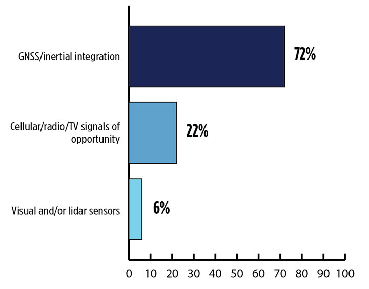
    In our survey, nearly three quarters (72%) of respondents in this sector said positioning could best rely on tight integration between GNSS and INS. For comparison, inertial technology wasn’t even mentioned in the 2017 State of the GNSS Industry Report. This year for the first time, GPS World offered an Inertial Buyers Guide for our readers (see our May issue).

    What is the best additional solution for positioning in GPS/GNSS-challenged environments? (Source: GPS World 2018 State of the Industry survey)
    What is the best additional solution for positioning in GPS/GNSS-challenged environments? (Source: GPS World 2018 State of the GNSS Industry survey)

    Practical autonomous navigation — the current ambition of automakers (and Google) — hits a roadblock when it comes to uninterrupted positioning. We all know GNSS reception has its limits, notably in many places that vehicles travel such as tunnels, beside tall buildings and in parking garages. Inertial positioning fills that gap, making it especially advantageous for meeting the challenges of autonomous navigation.

    Inertial measurement units are generally based on multi-axis combinations of precision gyroscopes, accelerometers and magnetometers using algorithms to determine location, direction and position. Gyroscopes measure the angular velocity; accelerometers measure overall acceleration; and magnetometers provide the direction of the magnetic field.

    Micro-electro-mechanical (MEMS) techniques have reduced the size, power consumption and costs of INS systems considerably, enabling their use in ever more applications, including unmanned aerial vehicles.

    As a result, products that combine GNSS + INS are being introduced at an increasing rate, with more than a dozen major announcements in the past year. According to one study, the INS market is projected to grow from US$11.89 billion in 2017 to US$19.67 billion by 2023, a compound annual growth rate of 8.76%.


    For more results from the 2018 State of the GNSS Industry, see this page.

  • 2018 State of the GNSS Industry Report

    2018 State of the GNSS Industry Report

    Trends, Obstacles and Opportunities

    Cover: Toria/Shutterstock.com
    Cover: Toria/Shutterstock.com

    Conducted online in July 2018, the GPS World State of the GNSS Industry survey compiled detailed answers to 30 key questions from 273 respondents, spread across six continents.

    Prominent insights gained, and outlined in these pages: the PNT sector is booming, as opportunities outnumber obstacles; well-trained engineers are at a premium; and the Internet of Things is the newest market driver, perhaps the most powerful yet.


    Insights from the Report

    Opportunities for growth in the GNSS industry

    Wireless and consumer emerge as key players for growth

    GPS World report: Survey sector favors multi-GNSS

    GPS World survey: UAVs on a roll to dominance

    Information key to managing amid complex change for GNSS OEMs

    Inertial navigation emerges as winning co-star for transportation sector

    The current state of the Defense, Security and Government PNT sector

    GPS World survey: Capturing the world with maps

  • GPS World survey: UAVs on a roll to dominance

    GPS World survey: UAVs on a roll to dominance

    The sector a driver for change across industries

    As precision guidance, autonomous operations, high-definition geocoded images and high-volume data processing all improve, drone use will continue to increase. OEM receiver manufacturers, sensor suppliers and data-handling companies play key roles in development, and stand to profit thereby.

    In particular, use of drones is growing in land management, construction, mining, and farming. An open-pit mine operation can be supported through detailed drone inspection producing high-resolution images. Processed images and data enable keeping tabs on inventory, site changes over time, identifying best areas for further extraction, and monitoring and managing vehicle movement. These tasks required huge amounts of time in the past. Drone overflight and processing tools condense all the effort as well as producing enhanced results to enable faster and clearer decision-making.

    What is the biggest challenge for the UAV industry? (Source: GPS World 2018 State of the Industry survey)
    What is the biggest challenge for the UAV industry? (Source: GPS World 2018 State of the Industry survey)

    Defense. Surveillance and reconnaissance are probably the biggest military drone applications. Carrying payloads that include color video cameras and infrared night vision cameras, more than 19,000 drones are now in the arsenal of the U.S. Army, Air Force, Marines and Special Ops, and more have gone to other nations’ militaries.

    Flying at relatively low altitude, with somewhat limited range and powered by a single quiet electric motor, these drones have become essential in gathering forward-situation intelligence.

    Other UAV craft provide higher altitude, longer-duration surveillance and reconnaissance over wider range: up to 20 hours, up to 15,000 feet, more than 60 miles afield. Civilian versions of these craft are in development.

    Delivery. Respondents to our survey thought delivery will be a breakthrough application for drones. Amazon has several trials running globably. National civil aviation authorities need to move forward with plans to integrate drones into civilian airspace for this initiative to graduate to full-scale operations and achieve their objective of 30 minutes from order to delivery.

    What is the killer app for drones? What professional UAV market sector will most powerfully drive adoption and influence new regulations for unmanned aerial vehicles? (Source: GPS World 2018 State of the Industry survey)
    What is the killer app for drones? What professional UAV market sector will most powerfully drive adoption and influence new regulations for unmanned aerial vehicles? (Source: GPS World 2018 State of the Industry survey)

    Precision Agriculture. One of the most significant applications which seems to be missing from survey responses is agriculture. Both quadcopters and hybrid fixed-wing/copter drones are in widespread use to capture image data overflying crops, and then process the data and build crop analytics. Graphic results point to how crops can be managed to increase yield.

    Making this work is a combination of sensor payloads gathering visual, video, lidar, thermal and hyperspectral data; the secret sauce lies in how the data is processed and presented to farmers. Emphasis is placed on exactly how “green” crops appear when inspected by the various sensors. A number of companies offer services for farmers to optimize crop management.

    All these areas are show significant drone growth. Let’s not forget facility, transmission line and pipeline inspection — tasks where drones excel at increasing efficiency and decreasing costs.


    For more results from the 2018 State of the GNSS Industry, see this page.


    Tony Murfin is a GNSS aerospace consultant with several decades experience at leading companies in the GPS/aviation and OEM sectors.

  • Wireless and consumer emerge as key players for growth

    Wireless and consumer emerge as key players for growth

    The Now and the Mobile Next for SatNav

    With 106 operational GNSS satellites flying today (or was that yesterday’s number?) satnav’s backbone is robust, variegated, supportive of growth across many industries — and poised to leverage even more prosperity. I’ve seen forecasts of as many as 400 satellites, well beyond GNSS proper and involving low-Earth orbit telcomm constellations, constantly patrolling space above us and beaming down positioning, navigation and timing (PNT) intelligence.

    Where do you see your efforts focusing primarilly over the next decade? (Source: GPS World's 2018 State of the Industry survey)
    Where do you see your efforts focusing primarilly over the next decade? (Source: GPS World’s 2018 State of the Industry survey)

    A draft headline for the cover of this issue — The Sky’s the Limit! — actually underestimated. Not even the sky is the limit.

    Mobile. GNSS-enabled tablets and smartphones provide navigation, traffic and congestion maps to billions. These features will continue to drive demand for GNSS in all electronic equipment. As we move from the internet to the internet of things (IoT) as the dominant paradigm of advanced and developing societies, GNSS will boom louder than we have heretofore known it to do.

    What is the industry “Issue of the Year?” (Source: GPS World's 2018 State of the Industry survey)
    What is the industry “Issue of the Year?” (Source: GPS World’s 2018 State of the Industry survey)

    Communication and location-enabled transportation services such as Lyft and Uber provide only one example of novel GNSS uses that have become the norm.

    Tracking devices, whether personal, vehicular, or affixed to large assets, constitute a quiet though muscular growth market. The GPS tracking device generates high demand from industries such as information technology (IT), transportation, and telecommunication, providing real-time intelligence and advance diagnoses about products, vehicles and people, valued by consumers and businesses, enhancing security and safety — key concerns that will only grow in an increasingly vulnerable world.

    What is the key challenge for positioning and navigation in the wireless and consumer space? (Source: GPS World's 2018 State of the Industry survey)
    What is the key challenge for positioning and navigation in the wireless and consumer space? (Source: GPS World’s 2018 State of the Industry survey)

    Volume! The GPS tracking segment alone is expected to reach $2.53 billion by 2023, nearly 12% annual growth. Other mobile segments will increase in parallel. Don’t be deceived by the low-cost of low-accuracy tracking devices. Volume! Volume! Volume! is just as powerful a mantra as Location! Location! Location!

    With the wireless carriers and IoT behind it, GNSS will see growth a-plenty and virtually no downside. U.S. cell carriers are now selling access to your real-time phone location data, a key signal that economic giants put high value on the technology.


    For more results from the 2018 State of the GNSS Industry, see this page.

  • GPS World report: Survey sector favors multi-GNSS

    GPS World report: Survey sector favors multi-GNSS

    Health compares favorably with rest of industry

    2018 State of the GNSS Industry survey respondents who identified themselves as from the survey sector constituted 30% of the total, corresponding to the percentage of the magazine’s readership.

    What is the most promising and practical way to gain the increased accuracy that survey and other high-precision applications continue to demand? (Source: GPS World 2018 State of the Industry survey)
    What is the most promising and practical way to gain the increased accuracy that survey and other high-precision applications continue to demand? (Source: GPS World 2018 State of the Industry survey)

    Higher Accuracy. Regarding the most promising technology to get the increased accuracy that surveying continues to demand, the outright choice was “dual-frequency, dual- or multi-constellation GNSS,” with “real-time kinematic” coming in second. Surprisingly, the newest technology to be introduced to GNSS receivers, inertial correction, lagged at just over 5%.

    Inertial correction devices, which contain gyroscope and accelerometer technology, are now being installed in survey-grade receivers to increase accuracy and productivity. It’s a gamechanger in GNSS data collection for surveyors, so I am surprised by the survey results. These sensors work in conjunction with the receiver to more accurately collect positional information in relation to the point being acquired. While RTK positions are normally collected at 1-20 Hz, the inertial device works in tandem to further refine a more accurate location. As this technology becomes more publicized in phones and other devices, the surveying community will begin to take notice.

    What role will drones (UAVs) play during the next three years in the survey sector? (Source: GPS World 2018 State of the Industry survey)
    What role will drones (UAVs) play during the next three years in the survey sector? (Source: GPS World 2018 State of the Industry survey)

    Drones. Concerning the role that drones (UAVs) will play in the next three years, by a slim margin — 47% to 42% — respondents state that up to 20% of their work will be completed by UAVs vs. those who feel less than 10% of their work will be done by a drone. Only1.3% answered that UAVs will take over most of their work and displace surveyors in the field for specific survey tasks.

    I see UAVs becoming a standard equipment much like the EDM/total station and GNSS receivers, as it is clearly a unique tool for not just collecting visual images but as a remote sensing device. While it won’t replace workers in the field, it will allow crews to become more efficient, tech-savvy and valuable for human-only types of data collection.

    Business. A whopping 85% of the survey sector found this market either “very healthy, with strong growth” (37%) or “relatively healthy, with moderate growth” (48%). This compares with total of 79% across all GNSS industry sectors. So we’re on top! That is, we are doing comparatively well amid the rest of the GNSS industry — which itself is in very good shape indeed.

    Poll results reflect the positive nature of the surveying profession in relation to technology, specifically GNSS and the utilization of UAVs, in our every day work. Previously, introduction of new technology has been historically unreliable, less than user-friendly, and expensive. The trend with newer technologies, however, has been quite the opposite with shorter, easier learning curves and lower cost of entry. These factors have led more surveyors to upgrade their equipment, implementing newer technologies and thus creating more efficiency in the profession.


    For more results from the 2018 State of the GNSS Industry, see this page.


    TIM BURCH is a professional land surveyor and secretary, Board of Directors, National Society of Professional Surveyors.

  • Opportunities for growth in the GNSS industry

    Opportunities for growth in the GNSS industry

    What is the greatest threat to GNSS over the next three years? (Source: GPS World 2018 State of the GNSS Industry report)
    What is the greatest threat to GNSS over the next three years? Click to enlarge. (Source: GPS World 2018 State of the GNSS Industry report)

    When we designed the survey of the global PNT community for the 2018 State of the GNSS Industry report, we put a couple of new wrinkles into the online questionnaire. We wanted to know, succinctly, what you felt was the number one obstacle to growth for your organization. And, with the same brevity, what you saw as the number one opportunity for growth.

    The answers most frequently given within each sector — mobile, OEM, survey, UAV, transportation, machine control, mapping and defense & government — appear on those respective pages in this issue. They weren’t the only answers, by far.

    Obstacles to Growth

    Other stumbling blocks that were called out included security, competitors (sometimes mentioned by name), politics (sometimes mentioned by party), budgets, funding, understanding, ignorance, management, bureaucracy, age, and that enduring favorite, time.
    The most frequently cited obstacles to growth were:

    • regulation, and
    • the lack of qualified staff, personnel, engineers.

    One ingenious survey-taker somehow found a way to cram 21 words into an answer box meant for only one or two. “In my industry, deep technical talent that addresses the specific issues. Without that, the ‘big picture’ judgments are often just wrong.”

    This problem is not new, nor is it particular to the GNSS/PNT industry. The fact that it is with us year after year suggests that it is not getting enough effective attention. Talented engineers can be imported, yes, if the homegrown supply falls short. In the current political climate, this may not be a strategy with legs. Even given a totally benign immigration regulatory landscape, it is far from a panacea. More on this in a moment.

    Growth Opportunities

    Various flavors of technology integration, both multi-GNSS and non-GNSS, led the pack in nearly every sector. Other popular answers included customization, broadband, autonomous navigation, Galileo, international markets, alt-nav, Brexit, the Cloud, M-code, anti-jamming, connectivity, flexibility, more clients, and, in riposte to the aforementioned obstacle: training, education, or simply engineering.

    The great American thinker Margaret Mead said, “We are continually faced with great opportunities which are brilliantly disguised as unsolvable problems.”

    If your organization encounters this perennial problem, this shortage of qualified staff that stifles innovation, inhibits growth, and causes you to pass on new ventures that are just out of reach, here’s the biggest whopping opportunity of all: get involved with higher education and engineering graduate schools in your area.

    The talent is there. If you’re not out actively cultivating, encouraging, training and recruiting it, those bright young engineering people will be drawn instead to Internet ventures or gaming software or other industries that sap the soul but nourish the pocket — and those are your true competitors.