Tag: adjacent band compatibility

  • US agencies tangle on possible C-band interference

    US agencies tangle on possible C-band interference

    Photo: guvendemir/E+/Getty Images
    Radio altimeters are critical in aircraft landing systems. (Getty image). (Photo: guvendemir/E+/Getty Images)

    As most GNSS industry insiders already know, the Federal Communications Commission (FCC) has licensed adjacent GNSS L1 protection frequencies to Ligado Networks (formerly Lightsquared) for its nationwide 4G-LTE network.

    Many objections emerged as expected this second time around from government agencies, industries and U.S. forces — yet the roll-out is still underway, pending actual interference occurring. This all in an attempt to find communications bandwidth for many emerging commercial radio applications.

    Now, as 5G C-Band 3.7–3.98 GHz wireless phone networks begin their FCC approved roll-out, the Federal Aviation Administration (FAA) has apparently lodged an unanticipated objection on the grounds that cross-interference could compromise aircraft radar altimeter and wireless communications that operate at 4.2 to 4.4 GHz in the C-band.

    While 5G wireless has already been operating in many parts of the world without reports of interference with aircraft systems, the FAA appears to be taking a more conservative approach to how aviation in the United States should co-exist with the new 5G phone wireless system. The FAA has proposed imposing an exclusion zone around airports for 5G wireless networks — which apparently have already been operating with reduced power in these areas — until cooperative operation has been proven.

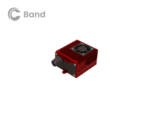
    Now along comes a new C-band wireless network (SkyLink) aimed at providing high-integrity unmanned aircraft systems (UAS) command and control (C2). The SkyLink company uAvionix has also developed a C-band Control & Non-Payload Communications (CNPC) radio for UAS applications.

    Together with Thales, uAvionics recently tested its radio with its SkyLink radio network. The network has been qualified in accordance with the RTCA DO-377 standard for a network management system that monitors network and radio link health, and the radio has been developed to the draft FAA Technical Standard Order (TSO) C-213A to support critical UAS operations.

    The network uses new DO-362A-compliant SkyLink C-band radios, integrates certifiable aviation-grade hardware and software, uses frequency agility, and provides critical fault monitoring and control capability. The objective is to obviate the loss of the C2 link with the vehicle, and thereby enable beyond-visual-line-of-sight (BVLOS) operations without an FAA waiver.


    It’s unclear whether the emergence of the C-band network — approved by both the FAA and FCC — will play a role in the current phone network interoperability issue. However, uAvionix reports that several sites in the United States and offshore are either rolling out C-band SkyLink networks or evaluating doing so.

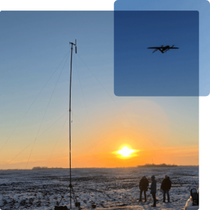
    • North Dakota already has an ISM-band SkyLink network at its UAS test site that will shortly transition to C-band.
    • The Choctaw Nation in Oklahoma under an FAA program seeks to enable BVLOS operations through a C-band C2 network.
    • New Mexico State University will use a Skylink C2 network around Las Cruces airport for small UAS (sUAS) operations and testing to overcome anticipated interference from nearby Air Force and Space Force operations.
    • The Tillamook UAS test range in Oregon has already installed the first ground site of a SkyLink network.
    • The University of Alaska at the Fairbanks UAS test site will use uAvionics radios for testing large, heavy UAS operations.
    • In Canada near the Jonesburg airport, a Skylink C2 network will support the safety case for BVLOS pipeline inspection operations for the oil industry.

    While many of these new networks are not yet fully online, the use of frequency hopping, safety-monitored C-band, and certifiable transmissions for UAS command and control appears to be moving forward rapidly. Because the FAA is supporting this testing phase, it seems inevitable that large-scale C-band network rollout for UAS C2 will happen eventually.

    5G phone networks, wireless UAS command and control, and aircraft safety systems essential for landing will need to find a way to co-exist and provide reliable, sustained service to their respective customer bases. Look for much more to develop in this ongoing tussle between industry groups and agencies who appear to have little in common, other than grudgingly sharing a crowded radio spectrum.

    Tony Murfin
    GNSS Aerospace

  • Parkinson questions long delay resolving Ligado issue

    Parkinson questions long delay resolving Ligado issue

    Tells Space Advisory group spectrum issues a concern for all

    Speaking to a gathering of space industry leaders, Dr. Brad Parkinson, the original chief architect for establishment of the Global Positioning System, outlined the threats to GPS signals posed by a proposal from Ligado Networks that is before the Federal Communications Commission (FCC).

    The proposal, which was initially approved, has been pending since 2011 over concerns about its impact on reception of GPS signals.

    When asked why the proposal has been pending for so long, Parkinson speculated a combination of the enormous sums of money potentially involved and difficulties for the FCC in arriving at an equitable solution were to blame.

    “I hope they find some spectrum for Ligado,” he said. “Just not the spectrum they are asking for.” Referring to the powerful proposed transmissions in frequencies adjacent to those used by weak GPS signals, he said “You don’t want to put a rock band next to a retirement home.”


    “You don’t want to put a rock band next to a retirement home.”


    Parkinson was speaking to the National Space Council’s User Advisory Group (UAG). The UAG was chartered under the Federal Advisory Committee Act in December 2017. Membership includes the CEOs of Lockheed, Boeing and other companies with interests in space, the Governor of Alabama, five former astronauts, and other leaders in space technology and policy.

    This was the first time the UAG’s agenda focused on GPS and positioning, navigation, and timing issues. Parkinson was invited to discuss the activities of the U.S. National Space-based Positioning, Navigation, and Timing Advisory Board. The UAG was interested in learning from the PNT Advisory Board’s experience, and about some of the issues it has encountered over the 15 years since its establishment in 2004.

    Parkinson used the PNT board’s experience with adjacent band compatibility and the Ligado proposal as an example of a particularly thorny issue. He said the Ligado issue was an ongoing concern that the UAG should share.

    Brad Parkinson shared his concerns over lack of Ligado decision with the National Space Council’s User Advisory Group (UAG). (Photo: Rebecca Zia)
    Brad Parkinson shared his concerns over lack of Ligado decision with the National Space Council’s User Advisory Group (UAG). (Photo: Rebecca Zia)

    Also that spectrum issues writ large should be of great concern to all users of space as the competition for spectrum from terrestrial users will continue increase. He called the Ligado proposal “a grave threat to GPS,” especially for aviation and high-precision users.

    During the course of the presentation Parkinson asked for the UAG’s support of the PNT Board’s recommendations on the Ligado proposal. He also asked the group to endorse the National PNT Executive Committee’s adjacent band compatibility methodology to any future such proposals.

    Parkinson’s presentation concluded with a discussion of how GPS is increasingly being used to support activities in space. It has long been used for booster guidance during the initial phase of space flight.

    Relatively recent work using side lobe signals from GPS satellites has caused engineers to recognize a Space Service Volume for GPS. This allows use of the signals for mid-course launch corrections, satellite station-keeping, rendezvous, and potentially trans-lunar navigation.

    Parkinson’s presentation is available online.


    Feature photo: Rebecca Zia

  • PNT Board opposes Ligado ‘lite’ proposal, DARPA seeks photonics

    PNT Board opposes Ligado ‘lite’ proposal, DARPA seeks photonics

    On Aug. 10, the National Space-Based Positioning, Navigation, and Timing (PNT) Advisory Board, the government’s GPS expert board, sent a letter to the National Executive Committee for Space-Based PNT (a multi-agency body that steers GPS policy) that concluded, “We strongly recommend your opposition to the Ligado proposal.”

    The letter sprang from a unanimous vote five days earlier to oppose allowing Ligado Networks to use spectrum neighboring the GPS band for terrestrial communications.

    Ligado possesses licenses to broadcast on two satellite bands located adjacent to the GPS frequencies. The company has been seeking permission from the Federal Communications Commission (FCC) to repurpose these licenses from satellite-based use to ground-based use from powerful tower transmitters.

    Ligado said in May it would lower the power in its proposal for the 1526–1536 MHz band to 9.98 dBW to avoid interference with certified aviation receivers. However, the PNT Advisory Board reiterated its opposition, saying that even if the transmissions’ power was lowered to just under 10 watts, it “will create totally unacceptable interference for a great number of GPS users in the United States.”

    From the Letter: “This risk is far too great, and far too many questions remain, for Ligado’s proposal to be approved. While there are many broadband alternatives (Ligado would be a very small percentage of this national asset), there is only one GPS. Any impairment to current and future uses is clearly contrary to the national interest. Therefore, implementation of their recently proposed ~10-watt operating scheme will create totally unacceptable interference for a great number of GPS users in the United States. In fact, despite power limits in their current amended application, it is probable they could still be allowed to increase this power over time. This would be even more destructive to GPS users.

    “We believe avoiding degradation over at least 90 percent of the region near Ligado transmitters is the absolute minimum protection for GPS receivers in each class. This would be a hypothetical 90 percent Protection Evaluation. This is not an endorsement of this level since, of course, all users would prefer 100 percent protection. The Department of Transportation (DOT) Adjacent Band Compatibility (ABC) study is the only validated test to verify degradation at various received power levels.

    “Those results inform that to insure degradation not exceed 10 percent of the Region (90 percent Protection) for High Performance receivers, either:

    Ligado maximum power can be no more than .0036 watts at the 400-meter spacing they had earlier planned. Tolerable power would be 3/10ths of 1 percent of their proposed ~10 watts. Or

    the closest spacing of Ligado transmitters is 20,000 meters (over 12 miles) for their proposed ~10 watt power level (see Figure 1).”

    Figure 1. The PNTAB strongly believes that 90% is the minimum Area Protection Criterion (maximum 10 % degradation). (Chart: PNT Advisory Board)
    Figure 1. The PNTAB strongly believes that 90 percent is the minimum Area Protection Criterion (maximum 10 percent degradation). (Chart: PNT Advisory Board)

    DARPA wants photonic integrated circuits

    High-energy photons emission (abstract illustration). (GiroScience/Shutterstock.com)
    High-energy photons emission (abstract illustration). (Photo: GiroScience/Shutterstock.com)

    The U.S. Defense Advanced Research Projects Agency (DARPA) Microsystems Technology Office is soliciting research proposals for the development of a new class of atom-based systems using integrated photonics and trapped atoms to enable high-performance, robust, portable clocks and gyroscopes.

    The military researchers are asking industry to develop relatively simple portable photonic integrated circuits (PICs) for high-performance position, navigation and timing (PNT) devices as an alternative to GPS for when satnav signals are not available.

    A PIC or integrated optical circuit, similar to an electronic integrated circuit, integrates multiple photonic (having to do with light) functions, providing capabilities for information signals imposed on optical wavelengths, typically in the visible spectrum or near-infrared, 850–1650 nanometers.

    A-PhI Program

    The Atomic-Photonic Integration (A-PhI) program seeks to develop trapped-atom based, high-performance PNT devices, reducing the complexity of these atomic systems by using PICs. According to the DARPA document, the PICs will replace the optical assembly behind devices such as sensitive and accurate angle sensors and clocks, while still enabling the necessary trapping, cooling, manipulation and interrogation of atoms.

    A-PhI aims to demonstrate that compact PICs can replace the optical bench of conventional free-space optics for high-performance trapped-atom gyroscopes and trapped-atom clocks without degrading the performance of the underlying physics package.

    Physics

    Atomic systems using trapped atoms have the potential to be made portable while maintaining their accuracy due to the atomic trap’s small size and the inherent isolation a trap offers an atomic system from the environment, especially from acceleration.

    Currently, these systems are bulky, heavy, and not notably portable, because of the complexity of the optical systems used to create the trap.
    In the past, efforts to miniaturize the hundreds to thousands of optical components in such benchtop systems have relied on removing optical elements, miniaturizing the remaining elements, and tightly integrating them in a small package.

    The products deliver degraded performance with the need to maintain very tight optical alignment, causing both poor environmental robustness and poor tolerance to design errors. Effective miniaturized atomic systems cannot be achieved at a reasonable cost with this approach.

    Recent developments in PIC research suggest that on-chip optical frequency combs based on microresonators, optical frequency synthesis, novel on-/off-chip coupling, wavelength demultiplexers, and on-chip phased arrays for dynamic manipulation of light fields can replace optical systems with readily manufacturable, low-cost chips without the alignment sensitivity of conventional free-space optics.

    Gyroscopes

    A-PhI also seeks to develop proof-of-concept trapped atom gyroscopes, a matter-wave analog of the interferometric fiberoptic gyroscope. Such a miniaturization effort could generate an order of magnitude improvement in angular sensitivity and dynamic range over current free-space products.

    A-PhI hopes to develop portable, high-performance, navigation and timing systems: the miniaturization of the optics of atomic systems without a decrease in performance. Subsequent work, the RFP asserts, will be required to incorporate the necessary compact and robust lasers and electronics to achieve a fully functioning, high-performance, portable PNT system.

  • Trying to accommodate GPS interference? Enough already

    Eight years on, and the money generated by a hedge fund still seeks to destabilize the Global Positioning System and the billions of people who benefit from it, whether they create it, administer it, sell it or use it.

    That accounts for just about everybody touched by telecommunications and the industrial network, including the brave individuals serving in the military.

    For rewards to the few, the U.S. government is lobbied to levy hardship on the many. In the service of that lobbying, the truth is manipulated to suit the ends. Sound familiar?

    See this article for facts and findings of years of detailed study of this matter, recounted in the recently released Department of Transportation’s Adjacent Band Compatibility (ABC) Assessment Final Report. That it appears almost a year after all the research and nearly all the analysis was completed suggests that powerful forces are at work, perhaps warring with each other, within the government. Let us hope that the guys and gals with the good hats on can prevail.

    The matter now rests with the Federal Communications Commission, an appointed panel not subject to the electorate nor to Congress, whose decisions sometimes carry a scent of influence from hidden quarters. Note particularly the recent ruling against net neutrality, which most agree runs counter to public interest and correlative with private corporate interests.

    As our news story states, the ability to use the mobile satellite services (MSS) band for terrestrial services is “limited.” The DOT ABC Assessment, using the 1-dB Interference Protection Criterion of a 1-dB drop in carrier-to-noise density ratio that’s accepted by everybody — specifically, every engineer — on Earth except Ligado Networks, demonstrates conclusively there is no chance the company could actually deploy a viable commercial terrestrial service in the MSS spectrum without disrupting or degrading vital GPS and GNSS services.

    The U.S. government and the GPS industry have both expended far too much money and time trying to accommodate a force-fit of a non-compatible use into the bands adjacent to the radionavigation satellite service band, to the benefit of one commercial company’s bottom line.

    It’s high time for this nonsense to stop. Nobody, least of all the government and the GNSS industry, owes Ligado anything.

  • The Adjacent Band Compatibility Assessment: What it means and why it matters

    The Adjacent Band Compatibility Assessment: What it means and why it matters

    The culmination of several years of test and analysis conducted by the U.S. Department of Transportation, the assessment will play a key role in the Federal Communications Commission’s upcoming decision on a proposal from Ligado Networks.

    The long-awaited Final Report for the U.S. Department of Transportation’s Adjacent Band Compatibility (ABC) Assessment was released on April 26.

    The report is the culmination of several years of test and analysis conducted by the DOT, with input and assistance from the public and federal agency stakeholders. Though not explicitly motivated by it, the assessment appears to be responsive to the Positioning, Navigation, and Timing (PNT) Executive Committee’s (EXCOM’s) Jan. 13, 2012, memorandum to the National Telecommunications and Information Administration (NTIA) that sought to develop metrics to inform commercial non-space proposals for use of frequency bands adjacent to those used by GPS, so that existing and evolving space-based PNT services “vital to economic, public safety, scientific and national security needs” were not affected by implementing such proposals.

    The assessment will likely play a key role in the Federal Communications Commission’s upcoming decision on a proposal from Ligado Networks to add an extensive complex of powerful ground transmitters to its system, broadcasting on frequencies allocated for satellites.

    Open and Transparent. Two key attributes of the ABC assessment were that it was conducted openly and transparently, with numerous public workshops announced via the Federal Register, and it was agnostic to any particular proposal for use of bands adjacent to GPS/GNSS services. The approach chosen by DOT in performing its assessment was to develop maximum tolerable effective isotropic radiated power (EIRP) levels that could be transmitted at differing frequency offsets from the GPS L1 center frequency.

    The term “adjacent” in this regard is a bit of a misnomer in that the assessment range extended to 100 MHz on either side of the GPS L1 center frequency of 1575.42 MHz. This approach was recently validated by the National PNT Systems Engineering Forum (NPEF), which found the ABC assessment was the only one of five test and analysis efforts conducted since 2011 on adjacent-band terrestrial operations that met all six of the test criteria recommended by the experts serving on the National PNT Advisory Board. The NPEF analysis is available here.

    Measurements on 80 civil GNSS and GPS receivers were performed at White Sands Missile Range (WSMR) in New Mexico. The Air Force conducted a prior week of testing on military GPS receivers at WSMR, and while the results of that testing are classified, an Air Force briefing at the November 2017 PNT Advisory Board meeting indicated the military receiver test results supported the conclusions drawn by the DOT ABC assessment. Certified aviation GPS/GNSS receivers were analyzed by RTCA Inc. and are being analyzed by the FAA in terms of determining power levels in adjacent bands that don’t exceed FAA Technical Standard Orders. However, the overall ABC assessment indicates that certified aviation receivers are not the limiting case for tolerable interference from adjacent-band services to GPS and GNSS receivers.

    Test Procedures

    Compatibility assessment for the civil receivers consisted of conducting the initial measurements at WSMR for six categories of receivers: aviation (non-certified), cellular, general location/navigation, high-precision, timing, and space-based receivers. These were evaluated to determine what DOT called Interference Tolerance Masks (ITMs) for each category of receiver and each receiver tested. The ITMs define the maximum aggregate interfering power that can be tolerated by a given GPS or GNSS receiver. The ITMs are based on the internationally accepted Interference Protection Criterion (IPC) of a 1-dB drop-in carrier-to-noise density ratio (C/NO) for the receiver, or, equivalently, an interference density-to-noise ratio (IO/NO) of –6 dB. This 1 dB IPC standard, which NTIA directed to be used in the NPEF evaluation of the original LightSquared (now Ligado) adjacent-band proposal in late 2011, is explained in great detail in a white paper the Air Force made publicly available in 2017.

    The assessment then developed, with input from the public at several workshops convened by the DOT, use cases to determine how close a receiver for a particular GPS or GNSS application might be to a base station or handset of a commercial terrestrial service in an adjacent band. Proximity distances of 10 and 100 meters were selected from these use cases, and maximum tolerable transmit EIRP levels for a given frequency offset were determined; see Figure 1. The high-precision receivers (HPRs) were the most susceptible to interference from terrestrial operations in the adjacent bands.

    Figure 1. Maximum tolerable power level for GPS/GNSS receivers at 1530 MHz. (Table: DOT)
    Figure 1. Maximum tolerable power level for GPS/GNSS receivers at 1530 MHz. (Table: DOT)

    One thing that seems clear is that, with tolerable transmit power levels in the milliwatt and microwatt range, the potential to use the bands near GPS frequencies for commercial terrestrial wireless services may be limited. Illustrating that point further, the assessment shows that, based on the assumptions in the study, HPRs can be affected at distances beyond 14 kilometers (see Figure 2), and that loss of lock for low-elevation satellites can occur at distances of up to 3 kilometers from a base station providing terrestrial services using characteristics adopted internationally in the International Telecommunication Union (ITU) study groups.

    Figure 2. Impact of a 29-dBW cellular base station transmitting at 1530 MHz on a high-precision GPS/GNSS receiver. (Chart: DOT)
    Figure 2. Impact of a 29-dBW cellular base station transmitting at 1530 MHz on a high-precision GPS/GNSS receiver. (Chart: DOT)

    Moreover, the assessment determined that the potential interference to other GNSS systems may be more problematic, noting that “the levels that protect all GNSS signals can be as much as 15 dB lower than those needed to protect L1 C/A signals from base station emissions with an average difference of 3.5 dB across all frequencies and five categories considered.”

    Galileo’s Role. Since 2013, according to a Public Notice from the FCC, the European Commission has sought a waiver of FCC rules that require licensing of receivers operating with foreign satellites so that Galileo service can be provided in the United States. The FCC has yet to act on this waiver request, which was issued in a January 2017 Public Notice, despite overwhelming public support and a positive recommendation from the Executive Branch in 2015.

    Figure 3. Bounding masks for each category corresponding to the 10 MHz LTE interference signal and L1 C/A GPS signal: general aviation, general location and navigation, high precision, timing, space-based, cellular. (Graph: DOT)
    Figure 3. Bounding masks for each category corresponding to the 10 MHz LTE interference signal and L1 C/A GPS signal: general aviation, general location and navigation, high precision, timing, space-based, cellular. (Graph: DOT)

    Conclusions

    It is well known that all receivers take in some power from signals transmitted in nearby frequency bands. Considering this fact, the ABC assessment is relatively unique in that it examines the overall spectral environment in which GPS/GNSS operations can be affected rather than just the band allocated to the Radionavigation-Satellite Service (RNSS, the broad radiocommunication service defined in the ITU and in domestic rules under which GPS and other GNSS systems operate) between 1559–1610 MHz. That the overall environment should be considered is an important aspect of any discussion of protecting GPS and other GNSS services given the U.S. National Space Policy that was signed into effect June 28, 2010, that directs the U.S. government to “take necessary measures to sustain the radiofrequency environment in which critical U.S. space systems operate.” This policy is still in effect, and it would be difficult to argue that GPS is not a critical U.S. space system.

    Recently, the reconstituted National Space Council adopted four recommendations, one of which related to spectrum used for satellite services and said that NTIA should coordinate with the FCC to ensure “the protection and stewardship of radio frequency spectrum necessary for commercial space activities.” Stewardship that is consistent with National Space Policy would include sustaining the RF environment for GPS.

    As the PNT EXCOM has made clear, GPS is “vital to economic, public safety, scientific, and national security needs” of the U.S. Moreover, economic analysis presented to the PNT Advisory Board in 2015 estimated the economic benefit to the nation of GPS services at over 68 billion dollars annually. With the release of the ABC assessment, definitive information is now available to inform decisions on use of frequencies near those used to provide space-based PNT services so these critical services are not disrupted or degraded.

  • Canada, US workshops focus on PNT threats

    Canada, US workshops focus on PNT threats

    Two workshops convened in recent weeks in the U.S. and Canadian capitals, respectively, sought to bring into focus looming threats to the nations’ positioning, navigation and timing capabilities and critical infrastructures. Some of the threats are pervasive — jamming and spoofing — and formed the general topic of the Canadian workshop. Some threats are specific — powerful terrestrial transmitters overwhelming GPS/GNSS receivers — and occasioned the U.S. gathering.

    Canada. In a first for Canada, the October 21 GNSS Vulnerabilities Innovation Policy (VIP) Workshop brought together 19 federal government departments as well as  provincial and municipal agencies and private sector companies.  U.S. State Dept. and Homeland Security gave presentations, as did the European Space Agency, Bell Canada, NovAtel and Spirent Communications.

    Integrity challenge for automotive positioning, presented by NovAtel
    Integrity challenge for automotive positioning, presented by NovAtel

    The workshop was sponsored by the the Federal Global Navigation Satellite Systems Coordination Board (FGCB), a government board with representations from various government departments and agencies. The GNSS Coordination Office (which organized the workshop) is hosted at Canada’s Ministry of Innovation, Science and Economic Development and sponsored by the FGCB members.

    Presentations covered such topics as Demonstration of the Geolocation of GPS Jammers, GNSS & the Telecom Sector, Detecting and Protecting Against GPS Cyberthreats, and Safety Critical, High Precision, GNSS Positioning for Autonomous Vehicles.

    United States. The U.S. Department of Transportation (DOT) hosted its fifth workshop on the GPS Adjacent-Band Compatibility Assessment effort on October 14. This lengthy, thorny and occasionally acrimonious process started out benignly enough in 2010 with the statement, “Demand for commercial spectrum to support broadband wireless communications has led the government to consider repurposing various radio frequencies, including the satellite communications bands next to GPS.”

    The workshop discussed the results from testing of various categories of GPS/GNSS receivers including aviation (non-certified), cellular, general location/navigation, high precision and networks, timing, and space-based receivers. The workshop also included a discussion on the development of use-case scenarios for these categories — which is where the going got heavy and differences of opinion truly emerged.

    DOT has posted all presentations from the workshop.  Scroll down to “October 2016 Workshop.”

    The furor stems from a renewed effort by Ligado, formerly known as LightSquared and now re-emergent from a 2-year bankruptcy process, to convert relatively inexpensive satellite-to-earth spectrum into very valuable terrestrial spectrum. The company stands to gain billions of dollars and secured rights from the process.

    Members of the DoT team presented the first results from the GPS Adjacent-Band Compatibility (ABC) Assessment, an effort to determine the power limits by frequency, or interference tolerance masks (ITM), needed to protect both existing and future GPS receivers. Test results indicated a need to limit interfering signals at different levels depending on the type of receiver being used. 80 receivers in six categories were tested: cellular, general location/navigation, general aviation, timing, high precision and space receivers. Certified and military receivers are undergoing separate tests.

    The tests of current receivers took place April 25–29 at White Sands Missile Range, New Mexico, using a 100 x 70 x 40 anechoic chamber. The signals used in the test included GPS L1 C/A-code, GPS L1 P-code, GPS L1C, GPS L1 M-code, GPS L2 P-code, SBAS L1, GLONASS L1 C, GLONASS L1 P, BeiDou B1I and Galileo E1 B/C. Tests were conducted within 100 megahertz on either side of the GPS L1 center frequency of 1575.42 using a 10-megahertz LTE signal and a narrow bandwidth 1-megahertz bandpass white noise signal.

    The tests were conducted for GPS and GNSS receivers processing signals in the 1559–1610 MHz Radionavigation Satellite Service (RNSS) frequency band, as well as receivers that process Mobile Satellite Service (MSS) signals in the 1525–1559 MHz band to receive differential GNSS corrections.

    The tests determined the power levels at which each device experienced a one-decibel degradation in the carrier-to-noise density ratio (CNR) at a particular frequency. The DoT team graphed results for each device. The recommended power limits were the lowest in frequencies closest to the GPS bands.

    The receivers most affected by the test transmissions were identified as high-precision receivers. They experienced interference at power levels as low as –90 to –95dBm at around 1550 MHz and –90 dBm at roughly 1610 MHz.

    highprecision-gps-l1-receiver-category

    The strictest limit for both the general aviation, general navigation/location, and timing receivers was a little below –80 dBm at about 1550 MHz, while space-based receivers were equally sensitive on both sides of the RNSS band with the toughest limit being about –85 dBm.

    FAA. The Federal Aviation Administration (FAA) has authority to set power and out-of-band emissions limits to meet aviation safety standards, and it had been thought that these limits might  address interference with other types of receivers as well. But the test results showed that “protecting the FAA-certified mask does not necessarily protect the rest of the receiver categories,” according to Hadi Wassaf, technical lead for GPS interference analysis at DoT’s Volpe Center.

    Use Cases. Ligado has proposed that position error as experienced by the user is a better guide to interference levels than degradation in the carrier-to-noise density ratio. The GPS community generally opposes this approach. The next step is the development of use cases. According to the test plan, use cases define the regions of operations for a receiver, and they identify applications that “that are vital to economic, public safety, scientific, and/or national security needs and any other factors supporting why this particular receiver model is important to be tested (e.g., quantity in use, economic impact, etc.).”

  • GPSIA Submits Filings Supporting 1 dB Standard for GPS Adjacent Band Assessment

    WASHINGTON – On Friday, Oct. 16, the GPS Innovation Alliance (GPSIA) submitted two filings regarding federal spectrum policy. Comments were filed in response to a public notice in the U.S. Department of Transportation’s (DOT) GPS Adjacent Band Compatibility assessment, and testimony was submitted for the record to a U.S. House Energy and Commerce subcommittee in response to its recent hearing, “Improving Federal Spectrum Systems.” Both filings stressed that the “1 dB standard” is the appropriate criterion for testing the compatibility of terrestrial broadband and GPS operations.

    The GPS Innovation Alliance has consistently supported the more complete use of underused spectrum where technically feasible. In both filings, GPSIA expressed support for each government entity’s ongoing efforts and stressed the importance of protecting GPS, one of the country’s most important and ubiquitous national utilities.

    Regarding the DOT effort, GPSIA offered suggestions relating to certain aspects of the proceeding and voiced support for the “1 dB standard” in testing — which would determine Adjacent Band Masks based on a measurement of received interference test signal power levels that cause a 1 decibel (dB) degradation in the receiver’s Carrier-to-Noise Density Ratio.  As outlined in GPSIA’s comments, the organization’s support for the 1 dB standard is based on its long and well-established history in international and domestic regulatory proceedings and difficulties associated with other standards.

    GPSIA wrote: “While DOT has proposed recording other performance metrics, such as loss of signal lock or degradation of pseudo-range or position accuracy, GPSIA believes these are inappropriate metrics for interference assessment since their inherent basis is an interference level that seriously degrades the RNSS spectrum environment and causes significant disruption to GPS receivers.”

    Degradation of accuracy or otherwise attempting to determine effects on the “user experience” are not practicable interference metrics, and DOT should rely upon the 1 dB protection criteria in derivation of the Adjacent Band Masks.  GPS receivers are used in a tremendous range of end user applications beyond simple navigation.  It is unclear how it would be possible to determine whether there has been “material degradation” in the functioning of this wide range of GPS applications, much less what constitutes degradation that is “material.”

    GPSIA also submitted testimony for the record in response to an Oct. 7 hearing by the House Subcommittee on Commerce and Technology, where the potential for repurposing spectrum currently reserved for use by satellite applications for terrestrial broadband was discussed, but without addressing the difficult technical challenges associated with repurposing satellite spectrum.

    A key theme raised in the GPSIA testimony is support for allocating similar uses for spectrum in close proximity to each other.  Doing so is an approach that is preferable to adopting receiver standards.  GPSIA also explained the unique technical differences between communications and navigation spectrum use.

    “A straightforward approach is to minimize the number of dissimilar spectrum applications in close spectral proximity to each other,” GPSIA said. “Put another way, similar spectrum uses should be grouped together to the greatest extent possible to minimize the number of band edges or ‘border areas’ where dissimilar uses in close proximity create serious interference challenges. This approach minimizes the need for the FCC to engage in extensive rule making to balance the interests of dissimilar spectrum uses in every spectrum ‘border’ area.”

    GPSIA then noted that “attempts to attribute Global Navigation Satellite System (GNSS) interference issues mainly to poor receiver design are misguided. The FCC has long understood that receivers designed to receive one set of frequencies can be ‘overloaded’ by transmissions in adjacent frequencies.”

    In fact, overload interference is not unique to GPS, whose receivers are typically designed to withstand adjacent band transmissions hundreds of millions of times stronger than GPS signals and compare favorably to other common types of mass market receivers.

    GPSIA again voiced support for the 1 dB standard for testing, explaining that communications systems operate above the noise floor spectrum while GPS signals are below the thermal noise floor when they are received.

    “Because GNSS operates below the noise floor, the most appropriate means by which to assess the potential of new adjacent band systems is whether the new service causes a 1 dB degradation in a receiver’s Carrier-to-Noise Ratio.” Other interference metrics, the GPSIA explained, “are based on interference levels that seriously degrade the GNSS spectrum environment and will cause devastating disruption to GPS receivers.”

    “Use of a 1 dB standard is vastly superior to an approach that attempts to assess whether there is ‘actual’ harm to an incumbent service, which wrongly assumes that you can accurately predict the impact of a new service across a heterogeneous series of devices in adjacent spectrum. Defining harmful interference by reference to a level of degradation to a particular key performance indicator among a limited universe of devices and applications fails to account for and support future innovation, including known and currently unknown applications which could take advantage of ever increasing accuracy of the position, navigation and timing functions of GPS. Use of a defined change in the noise floor (1 dB) provides a readily identifiable and predictable metric that all interested parties can take into account now and in the future.”

    GPSIA’s testimony concluded by urging policy makers to engage in “rational, long term spectrum planning,” noting that a focus solely on regulation of receiver characteristics is likely to have limited usefulness and may be inefficient and harmful to continued innovation in affected spectrum uses.

    The GPS Innovation Alliance recognizes the ever increasing importance of Global Positioning System (GPS) and other Global Navigation Satellite System (GNSS) technologies to the global economy and infrastructure and is firmly committed to furthering GPS innovation, creativity and entrepreneurship. The GPS Innovation Alliance seeks to protect, promote and enhance the use of GPS. For more information, visit www.gpsalliance.org.

  • DoT Hosts Third Workshop on GPS Adjacent Band Compatibility

    The U.S. Department of Transportation will host a third workshop to continue discussions of the GPS Adjacent Band Compatibility Assessment on March 12.

    The workshop will focus on the following topics:

    1. Identification of GPS and GNSS receivers to be considered for testing that are representative of the current categories of user applications
    2. Discussion of a GPS/GNSS receiver test plan.

    Anyone interested in presenting on either or both of the above topics should contact Stephen Mackey by March 2.

    The workshop will be held 8:30 a.m.-3:30 p.m. PDT at Aerospace Corporation, 2310 E. El Segundo Blvd., El Segundo, California.

    For more information, see the full Federal Register notice.

  • Transportation Department to Hold GPS Adjacent Band Compatibility Workshop

    The U.S. Department of Transportation is holding a “GPS Adjacent Band Compatibility Assessment Workshop” on September 18, 10 a.m.–5 p.m. Eastern Daylight Time. Registration for the workshop is required, and closes September 4. The general public can either attend in person or via WebEx.

    The workshop is being held to discuss implementation of a GPS Adjacent Band Compatibility Assessment. Discussion will focus on the various implementation steps of the assessment, including development of GPS receiver use cases, identification of representative GPS receivers, and development of a test and analysis program. “In particular, emphasis will be placed on the information needed from GPS receiver and antenna manufacturers, and the logistics of procuring and handling that information to safeguard manufacturer proprietary data,” according to the Federal Register.

    The sponsoring agency is the Office of the Assistant Secretary for Research and Technology, Department of Transportation.

    To register, send the following information to [email protected]:

    • Name
    • Organization
    • Telephone number
    • Mailing and email addresses
    • Attendance method (WebEx or on site)
    • Country of citizenship

    The meeting will be held at the U.S. Department of Transportation, John A. Volpe National Transportation Systems Center, 55 Broadway, Cambridge, MA 02142. ID is required to enter the building.

    For more details, see the Federal Register notice.