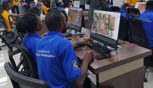
Hexagon’s Safety, Infrastructure & Geospatial division successfully deployed an advanced utility geographic enterprise asset management (EAM) system for the Electricity Company of Ghana (ECG). The smart EAM, featuring Hexagon’s G/Technology, will allow ECG to plan, manage and efficiently operate its distribution network to meet the growing needs of 4.5 million customers.
The enterprise system from Hexagon unifies data from a variety of geographic information systems (GIS), enabling bi-directional data flow with other systems based on the Common Information Model (CIM) standard. The system enhances ECG’s ability to geographically reference and manage assets with integrated tools for data surveying, capture and maintenance and network planning and calculation.
Mobile capabilities enable efficient inspections and maintenance, while a web portal assists employees with locating assets, reviewing the network and more. Migrating to Hexagon’s system will increase process efficiency and reduce asset-management costs by harmonizing systems, validating existing data and capturing missing data.
“The utility GIS is the critical component that fuels innovation in the utility,” said Keli Gadzekpo, board chairman of ECG. “This project is the foundation and the first step to modernizing ECG operations. It is the platform for digitization of electrical network assets, a prerequisite for bringing efficiency in the wire business.”
Photo: Hexagon
Part of ECG’s Modernizing Utility Operations Activity, the project was commissioned by Millennium Development Authority (MiDA), Ghana, on behalf of the Government of Ghana’s Millennium Challenge Account Entity Program and funded by the U.S. government.
“We are exceedingly grateful to Hexagon for working tirelessly to deliver this innovative product,” said Julius K. Kpekpena, Ag CEO and COO, Millennium Development Authority. “The technology sets Ghana’s biggest electric distribution utility on the path to modernizing its operations. The GIS is the foundation for modern tools to help ECG plan its networks, reduce losses, collect revenues and serve customers more efficiently.”
The project included procurement and installation of system software, server hardware, mobile field units and services for data migration by Hexagon, field validation of assets by PDSA Ghana (part of Hexagon), and production of aerial imagery by ILV Wagner using Hexagon’s Leica Geosystems surveying and airborne imaging technologies.
“Reliable electricity requires accurate data and tools to plan, design and manage networks, which can also reduce overall maintenance costs,” said Maximillian Weber, senior vice president, Global Utilities & Communications, Hexagon’s Safety, Infrastructure & Geospatial division. “We are proud to support Electricity Company of Ghana in delivering quality service to its customers.”
Advancements in sensors, cameras and automation have fueled the growth of the aerial imaging industry, which is expected to reach $2.83 billion by 2022.
By Swamini Kulkarni
Unmanned aerial vehicles (UAV), or drones, often gain the spotlight with to their ability to capture the view from a vantage point. For years, airborne cameras have clicked never-seen-before pictures across planet. Now imaging technology is utilized to monitor natural calamities and borders of countries.
Drones have been quickly adopted in various industries including surveillance, geospatial mapping, post-disaster monitoring, and even entertainment. The advancements in sensors, cameras and automation have fueled growth of the aerial imaging industry.
Cameras mounted on balloons, kites and now drones are used widely across various verticals such as government, agriculture, civil engineering and research. Surveillance through satellite imagery has challenges, many of which drones can overcome. Drones can be used whenever we want and can be equipped with lidar systems, geographic information systems and advanced cameras. This has created lucrative opportunities in the aerial imaging industry.
According to Allied Market Research, the global aerial imaging market is expected to reach $2.83 billion by 2022, growing at a CAGR of 12.9% from 2016 to 2022. The launch of novel and intuitive cameras has further increased the popularity of aerial imaging.
Advent of novel, intuitive cameras for aerial imaging
AirSelfie, a prime market player in the aerial imaging industry, launched AIR PIX aerial camera at Consumer Technology Association (CES) 2020. The company announced that it has started shipping AIR PIX+ to customers the world’s smallest pocket-sized aerial camera. Moreover, it declared that it would make available AIR DUO, the aerial camera equipped with the dual parallel camera later in 2020. Both of these cameras offer state-of-the-art technology and would prove to be vital in aerial imaging and capturing videos from the air.
Skydio, the leading U.S. manufacturer of drones and autonomous flight technology, recently launched new software solutions and autonomous drone platform for situational awareness and inspection. It is observed that despite the potential drones showcase in aerial imaging, its adoption is still limited due to concerns regarding the risk of crashes of autonomous drones.
Moreover, the requirement to hire experienced pilots and data security concerns prevent firms from scaling their aerial imaging programs. That’s why Skydio aims to unlock the potential through this autonomy software and change people’s perspective toward drones.
In addition, the company has partnered with Eagleview, a leader in aerial imagery industry and data analytics to empower home insurance agents to offer accurate inspection of residential homes without the use of expert drone pilots. This technology is expected to be available in the fourth quarter of 2020.
Artificial intelligence: Future of aerial imaging
Today, every industry is searching for ways to operate devices remotely or at least with minimum physical contact. With the experience of global pandemic keeping in mind, the future is clearly bright for autonomous drones.
Several industries, including aerial imaging, rely on advancements in autonomous UAVs. Moreover, the success of aerial imaging depends on both autonomous drones and carefully dealing with the data gathered by aerial cameras. This is where artificial intelligence (AI) comes into the picture.
For use of aerial imaging for property surveillance, there is a dire need for a solution that can streamline data analysis, make sense of the data gathered by cameras, and scale up the level of details offered by aerial imaging.
AI-based aerial imaging can be used for automated property analytics and streamline facilitation of risk underwriting and claim management. Moreover, it can offer datasets to improve risk modeling. AI-powered aerial imaging technology can leverage AI to detect changes in property evaluation, which can benefit public safety and city planning.
COVID-19 increases data demand
We live during a period of drastic change. The COVID-19 pandemic has influenced almost every industry across the globe and has increased the demand for quality of data despite a lack of resources. Moreover, there is a need for faster and better data analysis to help industries scale up. The incorporation of AI and aerial imaging can benefit organizations to scale up their operations and streamline their processes at affordable costs.
Nearmap, a prominent aerial imagery company, has launched its innovative Nearmap AI for automatic aerial imagery insights at scale. This technology is the first among aerial imagery to offer AI analysis along with high-definition aerial images on a commercial scale. Moreover, it enables customers to automatically detect ground features and verify insight against aerial imagery at a larger scale.
It is clear that the use of aerial imaging will increase in the future. Moreover, the integration of AI in aerial imaging will help organizations to scale up their business and aid in data analysis to gain valuable insights.
It is safe to say that the aerial imaging technology has changed over time, but the desire of humans to see the world from a high above has been constant, which is exactly what should keep aerial imaging technology profitable in years to come.
Allied Market Research is offering a market report on aerial imaging.
Swamini Kulkarni
Swamini Kulkarni holds a bachelor’s degree from Pune University, India, and works as a content writer.
Photo: Michael Chapman/iStock Editorial / Getty Images Plus/Getty Images
Aerial perspective and mobile operation management system combine to inform deployment, give increased situational awareness, and save critical time
A new strategic partnership between DJI and Rosenbauer International AG will enable emergency scenarios to be dealt with quicker, more safely and more efficiently, according to the companies.
DJI makes civilian drones and aerial imaging technology, and Rosenbauer manufactures fire service vehicles and firefighting equipment.
The two companies will work together to bring the benefits of digital emergency response management to anyone involved in being called to tackle an emergency situation.
Whether used by a private company at an airport or industrial facility, or a local fire department called out to an emergency even in severe weather, an aerial perspective combined with Rosenbauer’s operation management system enables the situation to be quickly assessed and informed decisions made regarding the safest and most efficient deployment of personnel.
Rosenbauer’s operation management system is the information management system for firefighting operations that supports emergency crews on site with relevant information such as fire safety maps, hazardous material data or vehicle rescue sheets.
Data from DJI’s drone fleet management software, FlightHub, will be integrated into Rosenbauer’s operation management system, giving additional visual and thermal data to the decision maker of the operation.
The information can then be relayed to operational units at the scene on a tablet or displayed on monitors back at the command center giving a full overview of the situation. Informed decisions can be made in real time regarding the efficient and safe deployment of resources such as personnel, vehicles and other equipment.
Data safety is paramount and all information that is delivered to the Rosenbauer operation management system in real-time, and from DJI’s FlightHub, is stored on a server in the highly secure computer center of a well-known European telecommunication firm. The data traffic is secured and encrypted. During deployment, the data is also synced with all mobile end devices so that every operational team has the same information, and it is kept in a closed loop.
“Speed and a truly complete overall picture are key criteria for success when emergency service teams have to make purposeful decisions under time pressure. We have already supported their efforts to meet these criteria with our IT solutions, which range from efficient vehicle management to navigation, right through to alarm applications,” said Dieter Siegel, CEO of Rosenbauer International. “This cooperation with DJI enables us to consolidate our role as a digital pioneer while we work together to develop an integrated technology for comprehensive, data-based firefighting and disaster management.”
“DJI is proud to bring its drone technology to support Rosenbauer’s excellence in fire apparatus manufacturing and its vision of empowering firefighters with the best possible tools for emergency response and disaster relief. At DJI, we aim to provide reliable, scalable drone offerings that empower firefighters, search and rescue and public safety teams to benefit from this technology,” said Roger Luo, President, DJI. ” It plays an increasing role in saving lives, time and resources on a daily basis. This integration is an important step for this long-term partnership, and our commitment demonstrates an increasing maturity in the adoption of drones for firefighting professionals.”
Vexcel Imaging, a provider of aerial imagery data, large-format aerial cameras and photogrammetry software, has signed a definitive agreement to acquire the imagery sourcing group from Verisk’s Geomni business.
The acquisition will combine Geomni’s imagery surveying and content-related teams and assets into Vexcel. Verisk, a data analytics provider, will be a minority owner in Vexcel with full access to all aerial imagery libraries.
The combination of Geomni’s fleet of fixed-wing aircraft and aerial operations, mapping business and oblique aerial image library together with Vexcel’s sensor business and data program will create a world-leading geospatial data library.
Geomni’s analytics team and assets will remain part of Verisk and continue to focus on world-class advanced analytics. The team will work closely with Vexcel on a strategic road map and joint projects.
“The strategic alliance between Vexcel and Verisk demonstrates both companies’ resolve to drive rapid innovation across imagery and analytics — to enter new markets, create new categories, and better serve commercial and insurance customers,” said Jeffrey C. Taylor, president of Geomni. “Partnering with Vexcel is a huge leap forward in the services we can provide customers.”
Vexcel Imaging was founded in 1992. The company’s successful line of UltraCam systems was launched with the first UltraCam in 2003. Vexcel is headquartered in Boulder, Colorado; operates an office in Graz, Austria; and will now have teams and operational hubs strategically located throughout the United States and in Spain.
“Our alliance with Vexcel benefits our customers through a unified, robust, and rapidly expanding global aerial imagery library that will deepen their understanding of ground truth,” said Mark Anquillare, chief operating officer of Verisk. “The combination of Verisk’s and Vexcel’s data will provide tremendous coverage for customers and help drive Verisk’s proven ability to innovate advanced analytic solutions.”
“By combining forces with Verisk, we’re making a progressive move to accelerate innovation within the geospatial data industry,” said Erik Jorgensen, chairman and CEO of Vexcel Imaging. “Vexcel and Verisk share tremendous synergies, and we look forward to bringing the definitive imagery and geospatial data library to the market — unmatched in its size, quality and breadth.”
Vexcel maintains a strong partnership with the Geospatial Intelligence Center (GIC), an insurance industry consortium spearheaded by the National Insurance Crime Bureau (NICB), a nonprofit organization dedicated to fighting insurance fraud and crime, and powered by Vexcel’s data program. The GIC empowers its member insurers to improve their decision making and risk management by leveraging aerial imagery and data in visual tools and automated processes. The partnership will provide enhanced support to GIC member insurers in the form of additional flying and processing capabilities as well as access to the newly scaled and unified geospatial library and enhanced analytics.
The transaction is expected to close the first quarter of this year, subject to the completion of customary closing conditions.
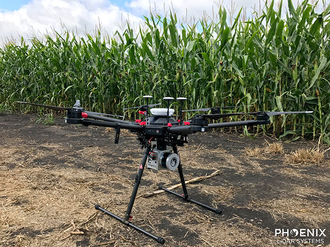
Phoenix Lidar’s Scout System features NovAtel SPAN GNSS/IMU equipment and a pinwheel antenna. Combined with Phoenix’s hardware and software, this lightweight UAV lidar system serves in agriculture, construction and other general mapping applications. Here the Scout is integrated with the DJI M600 Pro UAV. (Photo: Phoenix Lidar Systems)
As a UAV flies, it is subject to roll, pitch and yaw movements, adversely affecting the high-definition imagery that industrial-grade UAVs are designed to collect. Three measures combat unwanted movement: a stabilizing gimbal, a high-quality GPS/inertial measurement unit (IMU) integration, and orthorectification of the data during post-processing.
Imaging applications are driving all sectors of the booming UAV market. The increasing availability and variety of compact, robust, lightweight sensors, employing a range of super-resolution and often multi-spectral and hyperspectral technologies, continuously expand and improve UAV applications.
Three companies exhibiting at the Association for Unmanned Vehicle Systems International’s (AUVSI’s) massive Xponential show May 1-3 will showcase recent advances in this arena.
Challenges of Airborne Imaging. Size and weight govern UAV deployment.Imaging sensors must fit compact payload bays. An integrated UAV solution will typically include an imaging sensor, a high-performance GPS/inertial measurement unit (IMU), and a data storage hub to collate streams of data from all connected instruments.
Software geared specifically to flight supplies image orthorectification and manages sensor operation during the mission, enabling users to input GPS coordinates for sensor operation. Outside of defined coordinates, the sensor will not collect data, reducing the amount of data to store or transmit.
Immediate or real-time processing and georeferencing of imaging products has always been key to defense and security applications; it becomes critical for precision agriculture, cartography, civil engineering, remote monitoring and surveillance, intelligent inspection, disaster preparedness and risk study, newsgathering, cinematography, tourism and even commercial advertising. A multisensor landscape view can improve a UAV’s ability to react intelligently without operator input.
Integrated GPS/INS exhibitors at the Xponential show include:
NovAtel (Booth 3219). The company uses a flexible technology platform and diverse OEM products, which include SPAN technology: tightly coupled GNSS receivers with IMUs for reliable, continuously available, position, velocity and attitude, to deliver its vision of assured positioning — anywhere.
NovAtel offers TerraStar Correction Services to provide accurate real-time sub-meter or decimeter positioning around the world, anytime. Its Waypoint Inertial Explorer Xpress post-processing software provides the same core processing and utilities as Inertial Explorer along with simplified functions and workflows tailored for UAV markets and small project areas.
VectorNav (Booth 2214). Engineers at Octopus ISR integrated the VectorNav VN-200 GPS/INS directly into the optical bench of a gimbal to deliver positioning accuracy under flight conditions such as high vibrations, accelerations and temperature fluctuations. The device flies aboard the UAV Factory’s miniature Epsilon series of gyro-stabilized gimbals, enabling the Precision Geo-Lock feature, which combines a GPS-aided inertial navigation system with dedicated software algorithms and payload operator software.
The VN-200 features 16g accelerometers and 2000°/sec gyros in a postage-stamp-sized surface-mount device and a rugged package. Epsilon gyro-stabilized turrets are available with both VectorNav’s VN-200 single GPS-based INS solution and the VN-300 dual GPS-based INS.
SBG Systems (Booth 2535). The company developed specific calibration procedures to provide reliable heading even when UAVs tilt. Magnetometer calibration can be processed in 2D on the ground, or in 3D in flight. Qinertia software enhances inertial navigation systems performance by post processing inertial data with raw GNSS observables.
SBG Systems’ Ellipse 2 Micro high-performance inertial sensors reduces size and costs and for volume projects. It is available as an inertial measurement unit (IMU), or as an attitude and heading reference system (AHRS) or inertial navigation system (INS) running an extended Kalman filter, connected to an external GNSS receiver.
Phase One Industrial has introduced the iXU-RS aerial camera series, featuring a breakthrough central lens shutter design, according to the company. The new shutter technology is based on an innovative direct-drive concept with electronic charging that enhances exposure speed to as fast as 1/2500s, while guaranteeing half a million exposures, an unprecedented shutter life span.
The series’ flagship 100MP iXU-RS1000 camera system, with the advanced lens shutter, an exceptional capture rate of 0.6 seconds per frame and its CMOS sensor with superior light sensitivity of 50-6400 ISO, is uniquely designed to expand the efficiency of aerial imaging operations, including under deteriorating weather conditions or on days that were previously not conducive to image capture. This allows for faster flights and larger surface coverage.
For a small-bodied medium format camera, the iXU-RS1000 offers a large-format-quality experience thanks to its sensor technology and high-performance optics, which can deliver 11,608 pixels cross-track coverage. Users can gain more image coverage during a flight, while maintaining the same ground sample distance (GSD), or a lower GSD, while flying at the same height. Its small form factor supports multiple uses — as a standalone camera for photogrammetric work or as part of an array (to cover a larger swath) or as part of an oblique camera system.
Other iXU-RS series cameras include the 80MP iXU-RS180, and 60MP iXU-RS160 and 160 Achromatic systems. All iXU-RS series cameras feature accurate metric calibration, scalability to form multi-camera arrays, and easy integration with popular flight management systems and GPS/IMU receivers. There are seven available lens options, including: 32mm, 40mm, 50mm, 70mm, 90mm, 110mm and 150mm. Lenses have been designed and built for aerial photography by Rodenstock and Schneider Kreuznach, and factory calibrated for infinity focus.
Easily integrated into existing or new set-ups, the cameras offer maximum connectivity with diverse systems and help operators execute and manage missions, such as: surveying, mapping, critical infrastructure inspection and many other applications with greater reliability, cost effectiveness and operational efficiency. The iXU-RS1000 is also suited to four band-imaging applications.
Phase One Industrial has introduced its Phase One 4-Band Solution, which incorporates an innovative batch-processing tool that automates and simplifies the four-band aerial image generation process.
Adding a fourth band of near infrared (NIR) image data to three-band color (RGB) image data yields multispectral information useful in vegetation studies — in applications ranging from crop metrics for optimization, to vegetation health, environmental contamination and city observations for green site monitoring.
Synchronized Phase One metric aerial cameras.
The solution is composed of two synchronized Phase One metric aerial cameras mounted side by side on a specially designed base plate, a Phase One iX Controller and Phase One iX Capture software.
Images are captured in NIR and RGB bands simultaneously, and processed automatically to generate distortion-free images and perform fine co-registration of the pixels from NIR to the RGB images — including processing different image sizes — with seven different output options, including multispectral CIR images.
Complementing the solution’s software functionality, the use of two separate cameras to support higher system sensitivity permits operators to separately control capture settings so that they can operate under a wider range of lighting conditions.
“We very easily installed the cameras into the gyro mount, and all power and communications were automatically configured with the iX-Controller,” said Peter Bochmann, operator of Aerial SurveyS GmbH. “The output four-band images were incredible, showing an area of forest vegetation straight-away that needed attention; we would not have seen this detail with RGB images alone. The flexibility of the solution is also great, since you can combine any two Phase One metric medium-format cameras and accomplish multiple jobs without changing the setup.”
The Phase One 4-Band Solution offers a variety of benefits:
100MP sensors for RGB and NIR images, no NIR up scaling is needed;
CMOS sensors for maximum sensitivity;
Post processing is automatic, using the solutions’ iX Controller along with iX Capture;
Automatic individual aperture control and auto exposure mode is available for both cameras;
Direct connection to GNSS/IMU systems; coordinates are stored inside the EXIF data of each image to speed later post-processing;
Also available with 80MP RGB and 60MP Achromatic Sensors.
The ancient city-kingdom of Kourion on the southwestern coast of Cyprus can now be “seen” by those with impaired vision.
Kourion, part of the UNESCO World Heritage Site of Paphos, was once an important urban center. While most of the archaeological remains — including several buildings with well conserved floor mosaics — date to the Roman and Early Byzantine periods, the most ancient finds connect to settlements and tombs of the Ceramic Neolithic period (circa 5500-4000 BCE).
A tactile map: In summer 2015, sections of the virtual 3D model, including the amphitheater, were printed in 3D and displayed in the visitor center with Braille explanations, providing an interactive history to those with visual impairments.
British drone manufacturer QuestUAV, in cooperation with the Cyprus University of Technology, acquired high-resolution aerial images of Kourion Archaeological Park with a surveying drone, and then created a virtual 3D model from the images with Pix4Dmapper Pro.
The QuestUAV team (a pilot and laptop commander) flew over 100 hectare of the archaeological park at 400 feet with a Q-200 Surveyor drone equipped with a Sony A6000 camera and a 16mm wide-angle lens, taking 330 aerial photographs during a 20-minute, fully autonomous flight.
The automatic camera trigger and the gimbaled camera system enabled acquisition of pin-sharp pictures, even at wind speeds of up to 40 kilometers per hour.
The images have a ground sampling distance of 2.5 centimeters with an overlap of 80 percent in flight direction and 65 percent sidelap. During the flight, the Q-200 Surveyor recorded the GPS coordinates of each camera position in a log file, allowing for image geo-location.
The entire survey took no longer than an afternoon.
Icaros Inc., a provider of aerial imaging software, has released version 4.2.2 of OneButton. The release contains new features and improvements as well as a new flight planning software module. Here are the highlights:
Additional parameters have been added to enable users to create enhanced quality output products.
Users can now create their own parameter templates to run similar projects repeatedly with the same parameter set.
The image stitching algorithm has been enhanced to generate higher quality outputs for projects with high overlap.
Projects covering smaller areas can now be solved more accurately by utilizing a higher resolution terrain model of the area.
UgCS flight planning software is included free of charge with each installation.
Current users of OneButton software can download and install the latest version.
Icaros developed the OneButton family for geospatial end users to easily and automatically generate precise, fully orthorectified 2D maps and 3D models from frame-based aerial imaging systems. Originally engineered for manned aircraft sensors, the OneButton software has been modified to accommodate the unique collection conditions of unmanned aerial systems (UAS).
OneButton creates a complete image processing workflow for aerial image data and can front-end both GIS and analytics workflows to enable customers to solve challenging problems related to everything from agriculture and forestry to utilities and city planning. It is highly customizable to meet the needs of specific vertical market applications.
OneButton automatically processes raw raster imagery with onboard GPS/IMU data to stich the individual scenes together into a seamless, color-balanced orthomosaic meeting photogrammetric standards. Outputs include digital elevation models (DEMs), true color 3D point clouds, and multispectral mosaics – all ready for ingest directly into GIS and analytics software environments.
OneButton is application platform and sensor agnostic, and processes raster image data from small-, medium-, and large-format frame sensors capable of capturing visible RBG, multispectral, near-infrared, and thermal infrared data.
“This version of OneButton comes with significant improvements, from a more intuitive user interface, to more robust processing and output options. I am very pleased with the update,” said Eric Andelin, president of VERTX.
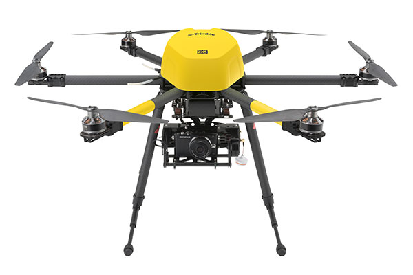
The Trimble ZX5 can reach smaller, remote environments faster, while providing accurate mapping data.
Trimble’s new ZX5 Multirotor Unmanned Aircraft System (UAS) — announced today — is an aerial imaging and workflow solution that captures and processes geo-referenced photo and video data for mapping, agriculture and inspection applications. The Trimble ZX5 complements the UAS portfolio with the ability to reach smaller, remote environments faster, while providing accurate mapping data for improved productivity in the field and back office, Trimble said.
“Unmanned aerial systems are powerful tools that are transforming geospatial-based mapping and inspection applications to positively impact our world,” said Todd Steiner, product marketing director in Trimble’s Geospatial Division. “Adding a multirotor solution to our portfolio provides options for our customers working across multiple environments to collect accurate spatial data, transform it to intelligence and create deliverables.”
With the ZX5, Trimble extends its unmanned aerial portfolio to include both fixed-wing and multirotor solutions, providing customers with a choice to meet their specific requirements. Trimble’s fixed-wing UX5 provides longer flight capabilities for large, open environments including farms, mines, canals, flood areas and forests — while the ZX5 is more suited for mapping smaller sites, including facades, obstructed areas, construction sites and standard aerial mapping applications.
The Trimble ZX5 multirotor UAS.
The ZX5 Multirotor is built for everyday jobs where image capture from tight spaces is common. Its vertical takeoff and landing capabilities allow users to work in tight places and obstructed environments where fixed-wing solutions are less suitable. It requires no launcher, is easy to assemble and includes everything needed to capture high-quality geo-referenced photos for aerial mapping and inspection applications.
The ZX5 includes a 16-megapixel camera to capture high-quality aerial imagery, down to 1-mm ground sample distance. The ZX5 also can be equipped to capture live video imagery for civil infrastructure, utility and oil and gas pipeline inspections.
Data captured by the ZX5 can be imported into Trimble Business Center Photogrammetry Module software to create detailed ortho-photos, digital elevation models, point clouds, volume calculations and 3D models, all without requiring specialized photogrammetry knowledge or experience. It also integrates with Trimble’s Inpho UASMaster module for advanced photogrammetric processing.
In addition, the Trimble ZX5 has been granted a Section 333 exemption from the Federal Aviation Administration.
Satellites, aircraft and unmanned aerial systems (UAS) collect imagery that can be displayed and analyzed within a geographic information system (GIS) to extract important information.
To familiarize GIS professionals and students with the advanced earth imaging technologies available today, Esri has publishedEssential Earth Imaging for GIS. The book is a field guide to Earth imaging, providing guidance to efficiently and effectively display, manipulate, enhance, and interpret features from an image.Essential Earth Imaging for GISprovides a basic education in remote-sensing technology, promoting the effective use of sophisticated multispectral and 3D imagery.
Chapters introduce readers to remote-sensing methods and types of imagery as well as how to display and enhance multispectral images, process images in a GIS to improve quality, generate three-dimensional data, and visually interpret images in a GIS to extract information from them.
The book provides hands-on experience working with imagery in Esri’sArcGIS for DesktopandArcGIS Online. Exercises include assigning colors in multiband images and extracting information from multispectral images by digitalizing features. Companion exercises and a free 180-day trial of ArcGIS are available by accessing theEsri Press Book Resources website.
Essential Earth Imaging for GISwas written by Lawrence Fox III, emeritus professor of forest remote sensing and GIS at Humboldt State University in California. The book serves as a starting point for GIS professionals who want to learn the basics of imaging technology so they can incorporate it more effectively into their work, while students can use this book as a reference for introductory GIS courses that make use of image display and analysis.
Essential Earth Imaging for GISis available in print (ISBN: 9781589483453, 128 pages, US$59.99) or as an e-book (ISBN: 9781589484313, 128 pages, US$59.99). The book is available at online retailers worldwide, atesri.com/esripress, or by calling 1-800-447-9778. Outside the United States, visitesri.com/esripressordersfor complete ordering options, or visitesri.com/distributorsto contact your local Esri distributor. Interested retailers can contact Esri Press book distributor Ingram Publisher Services.
Esri Press publishes books on GIS, cartography, and related topics. The complete selection of GIS titles from Esri Press can be found on the web atesri.com/esripress.
All Phase One Industrial aerial cameras now fully support the IGI AEROcontrol, GNSS/IMU positioning system, the companies announced. Aerial camera models include iXA-R, iXA, and iXU.
Phase One aerial cameras are high-quality industrial-grade camera systems, which have found wide success in the photogrammetry market, both among end users and OEM integrators.
AEROcontrol is a GNSS/IMU system for the precise determination of position and altitude of multiple airborne sensors. Beside the choice of MEMS- and FOG-based IMUs, the system is also suitable for mobile mapping applications. Used together with IGIplan and CCNS-5, a complete and comprehensive solution for mission planning, aircraft guidance with sensor management and geo-referencing is available to Phase One aerial camera users.
“With the addition of IGI’s AEROcontrol, users of Phase One aerial cameras are able to use IGI’s popular AEROcontrol, GNSS/IMU positioning system with a single camera or as part of an array,” said Dov Kalinski, general manager of Phase One Industrial.
“With the integration of the IGI AEROControl GNSS/IMU with the Phase One aerial cameras, all Phase One users now have access to geo-referencing with different IGI IMU models and IMU-based, precise stabilized mount control. This smart geospatial solution helps users obtain the best possible aerial photography results,” added Philipp Grimm, IGI marketing and sales manager.