SpaceWERX, the innovation arm of the U.S. Space Force, has selected Xairos Systems Inc. for a $1.9 million Direct-to-Phase II contract to develop a fusion positioning, navigation and timing (PNT) system. This project aims to integrate quantum and optical synchronization of clock ensembles to address critical challenges faced by the Department of the Air Force (DAF).
Xairos Systems is collaborating with Luminous Cyber Corporation and Eritek on this initiative. The team has recently completed a Preliminary Design Review. The Air Force Research Laboratory (AFRL) shared that the collaboration is part of a broader effort by the AFRL and SpaceWERX to streamline the Small Business Innovation Research and Small Business Technology Transfer processes.
AFRL and SpaceWERX seek to streamline the Small Business Innovation Research (SBIR) and Small Business Technology Transfer (STTR) process through faster proposal-to-award timelines, changing the pool of potential applicants by expanding opportunities to small businesses and eliminating bureaucratic overhead by continually implementing process improvement changes in contract execution, according to AFRL.
In 2018, the DAF launched the Open Topic SBIR/STTR program to broaden its funding for innovations. As part of this initiative, Xairos is developing innovative technologies that enhance the national defense of the United States.
TrustPoint has secured two Direct-to-Phase II contracts from SpaceWERX, totaling $3.8 million, to advance its GPS-independent ground control segment and develop an advanced positioning, navigation, and timing (PNT) security application. The application is designed to address critical challenges within the Department of the Air Force (DAF) and strengthen the United States’ national defense.
The Air Force Research Laboratory (AFRL) and SpaceWERX, the innovation arm of the U.S. Space Force and a division within AFWERX, have partnered to streamline the Small Business Innovation Research (SBIR) and Small Business Technology Transfer (STTR) processes. Their efforts focus on accelerating proposal-to-award timelines, expanding opportunities for small businesses and reducing bureaucratic overhead through continuous process improvements.
In 2018, the DAF introduced the Open Topic SBIR/STTR program to broaden its funds’ range of innovations. This initiative has paved the way for companies like TrustPoint to develop innovative capabilities contributing to national defense.
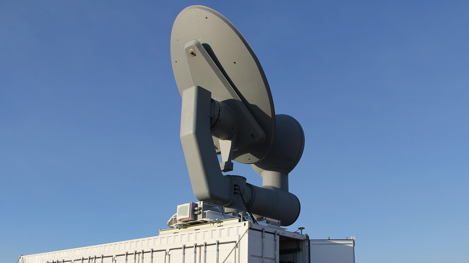
TrustPoint is developing a commercial GPS service using a C-Band low-earth orbit (LEO) satellite constellation. The system is designed to offer the high performance, security and availability required for autonomous navigation, critical infrastructure and national security.
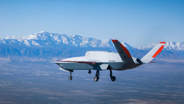
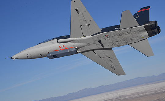
The Air Force Research Laboratory (AFRL) has sponsored the development of two unmanned vehicles aimed at accompanying and augmenting the capability of today’s front-line fighter/bomber aircraft. The Loyal Wingman story just took another step forward with the first flight of the General Atomics Aeronautical System Inc. (GA-ASI) developed X-67A at the company’s Gray Butte Flight Operations Facility near Palmdale, California.
General Atomics/AFRL X-67A in flight (Photo: Air Force Research Laboratory Public Affairs)
Little is currently known about the AFRL/GA-ASI unmanned aircraft, other than indications that it has been developed under a Collaborative Combat Aircraft (CCA) program and built on a common frame, which is intended to aid the rapid development of future new variants.
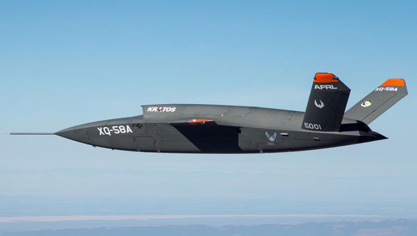
AFRL has previously sponsored Kratos to develop the XQ-58A Valkyrie, which is also intended to “work in teams with manned aircraft,” as a low-cost “attributable” asset commanded by a manned flying companion. The aircraft launches by rocket assist and is recovered vertically by parachute – the new ‘trolley’ launch capability allows the jet-powered Valkyrie to take off on a regular runway.
In earlier flight testing, communications between Valkyrie and both an F-22 Raptor and an F-35 Lightening front-line manned aircraft were established, demonstrating the manned/unmanned teaming concept. With a range of roughly 3,000 mi and an operational ceiling of 44,000 ft, the Valkyrie is intended to demonstrate how an armed, low-cost UAV can bring significant additional assets into combat situations. However, the original test article is now retired and has been put on display at the National Museum of the USAF in Dayton, Ohio, so its demonstration days appear to be over.
XQ-58A Valkyrie. (Photo: AFRL)
Nevertheless, Kratos has built several other production Valkyrie UAVs, which are reportedly undergoing tests with the US Airforce, Marines and Navy. Reports indicate that an XQ-58B electronics defense suppression version has been developed and demonstrated, along with other aircraft that have demonstrated weapons release from an internal stores bay, along with an intriguing release of a small UAV from that same internal bay.
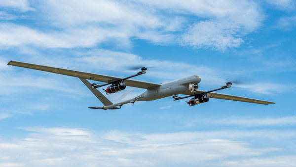
Boeing’s Aurora Flight Sciences has just launched the Skiron-XLE Class 2 UAV – Class 2 meaning that it’s small enough to fit in the back of a pick-up truck. It was derived from an earlier Skiron-X version, which had a wingspan of 16 ft, a length of 7 ft, a weight of less than 50 lb and a meager range of only 8 mi.
Skiron-XLE. (Photo: Aurora Flight Sciences)
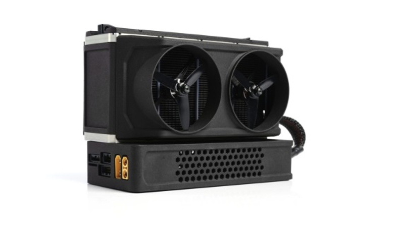
IE-Soar-800W fuel-cell and regulator. (Photo: IE)
Aurora has now come up with a way to extend the range of the vertical take-off and landing (VTOL) UAV by up to 47 miles and increase endurance from 3 hours to more than 5 hours. This was made possible by replacing the original battery power source on the Skiron-X with a compact hydrogen fuel-cell on the XLE supplied by Intelligent Energy (IE). The Skiron-XLE can be equipped with a gimbal mount electro-optic infrared (EO/IR) sensor and is aimed at the military/security reconnaissance role.
When fuel-cells are mentioned, some people may still think of the liquid oxygen/hydrogen sphere that blew up Apollo 13. Fortunately, however, technology has moved on significantly since this less commercial design of the 1960s. As an example, according to the company’s spec sheet, the Department of Transportation (DOT) certified IE-Soar-800W fuel-cell and hydrogen regulator offers 400 w for up to 5.9 hours. Hydrogen/oxygen gasses are combined across two semi-permeable membranes to generate power — no frozen gas-slush stirring is required.
Meanwhile, progress towards eVTOL air-taxi capability took a step forward for Archer and its Midnight aircraft. Stellantis has invested an additional $55 million into Archer’s efforts to build production capacity for up to 650 aircraft per year at its planned 350,000 sq ft facility in Georgia, scheduled to be completed in 2024.
Archer’s Midnight eVTOL. (Photo: Archer)
To clarify Stellantis’ background – the company includes manufacturers Fiat-Chrysler and Peugeot, which have merged to form the fourth largest vehicle company by sales behind Toyota, Volkswagen and Hyundai. Stellantis has a strategic funding agreement with Archer and the latest investment follows the milestone first test flight of Midnight where the successful transition from vertical lift to forward flight was achieved. The European conglomerate has also acquired up to $110 million in Archer shares on the open market and through this funding initiative.
Stellantis is working with Archer to bring its manufacturing expertise to the fabrication of Archer’s composite air taxi. High-volume car manufacturing and eVTOL building have a lot in common, and there is clearly common interest for a giant car company to gain access to the new eVTOL market.
To recap – GA-ASI has joined the CCA team with the first flight of the AFRL X-67A unmanned UAV, while Kratos continues with further testing of the Valkyrie CCA UAV with several U.S. forces. The latest generation of hydrogen fuel-cells is now extending the range and endurance of Aurora’s Skiron-XLE, while more investment flows in the eVTOL air taxi market.
TrustPoint, a commercial GPS and navigation technology company, has been awarded a Phase II Small Business Technology Transfer (STTR) contract by AFWERX, totaling $1.6 million. The contract focuses on the development of advanced, resilient navigation applications to meet the challenges faced by the Department of the Air Force.
In collaboration with the Naval Postgraduate School, TrustPoint aims to enhance its GNSS capabilities and pave the way for applications that will boost the national defense of the United States.
The Air Force Research Laboratory (AFRL) and AFWERX have partnered to optimize the Small Business Innovation Research (SBIR) and STTR processes. Their efforts aim to provide quicker proposal-to-award timelines, broadening the applicant pool to include more small businesses and reducing bureaucratic overhead through ongoing process improvements. Since the initiation of the Open Topic SBIR/STTR program in 2018, the DAF has expanded the scope of innovations it funds, with TrustPoint’s project commencing on April 2, 2024.
The U.S. Air Force Research Laboratory (AFRL) and RTX, formerly Raytheon, have successfully completed a three-week field test of the CHIMERA high-power microwave (HPM) weapon at White Sands Missile Range in New Mexico. During the test, CHIMERA applied directed energy to multiple static target variations and demonstrated end-to-end fire control by acquiring and tracking UAVs and maintaining tracking for the entire flight path.
The Counter-Electronic High-Power Microwave Extended-Range Air Base Defense system, known as CHIMERA, was built to fire highly concentrated radio energy at multiple middle-to-long-range targets. The ground-based demonstration system wields more power than other HPM systems to defeat airborne threats at the speed of light, according to Raytheon.
CHIMERA is part of the Directed Energy Front-line Electromagnetic Neutralization and Defeat (DEFEND) program, which is a joint service effort to design, build and test HPM systems for front-line deployment. Raytheon is partnering with experts at the AFRL, Naval Surface Warfare Center Dahlgren Division, and the Undersecretary of Defense for Research and Engineering to complete this project.
News from the U.S. Air Force Research Laboratory (AFRL)
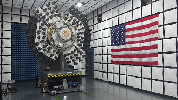
The Navigation Technology Satellite-3 (NTS-3) Vanguard program has reached a milestone in preparation for launch of the satellite in late 2023. NTS-3 is expected to push the boundary of positioning, navigation and timing (PNT) technology, paving the way for a more flexible, robust and resilient architecture for satellite navigation.
Prime contractor L3Harris Technologies delivered the NTS-3 space vehicle to an Air Force Research Laboratory (AFRL) integration and test facility at Kirtland Air Force Base, New Mexico. The satellite integrates an agile PNT payload with a Northrop Grumman ESPAStar bus to provide a space platform for AFRL and partner organization experiments and integrated capability demonstrations.
In 2019, the U.S. Air Force designated NTS-3 one of the first three Vanguard programs to deliver innovative, game-changing capabilities to the warfighter at an accelerated pace. NTS-3 is managed by the AFRL Transformational Capabilities Office and has program partners in both the U.S. Space Force and the U.S. Air Force.
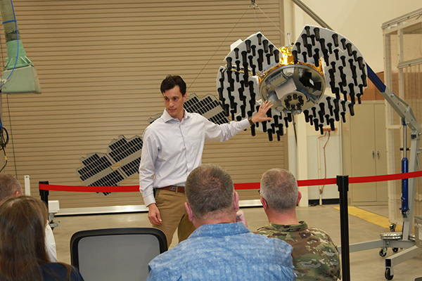
“This major milestone marks the transition from space system development at contractor’s facilities to the final stage of integration and test activities,” said Arlen Biersgreen, NTS-3 program manager. “The AFRL team will be overseeing and working closely with L3Harris and other key industry partners to apply an effective combination of contractor and government resources to successfully complete this phase of the effort.”
Arlen Biersgreen, NTS-3 program manager, uses a 1:3 scale model to describe the spacecraft and details of the one-year experimental mission during Media Day on June 23, 2022, at Kirtland Air Force Base. (Photo: U.S. Air Force/Andrea Rael)
AFRL and L3Harris are now completing the remaining intra-payload and payload-to-bus functional and performance tests, including the first radio frequency broadcast tests of the novel PNT signals that will be demonstrated from near-geosynchronous orbit after the NTS-3 launch.
Following those activities, the team will perform standard space environment tests that simulate the launch and space environments to verify that the system is ready for the rigors of experimental operations in space. Biersgreen added that experimental performance data from ground testing will be available for sharing with program partners in the next several months.
The Global Navigation Satellite System Test Architecture, or GNSSTA, developed by the Mitre Corporation in partnership with the AFRL Sensors Directorate, is crucial for meeting end-to-end NTS-3 mission objectives. GNSSTA is a reprogrammable software-defined receiver allowing users to receive both legacy GPS and advanced signals generated by NTS-3. It lays the groundwork for future operational receivers to provide the Space Force with options to prevent and respond quickly to common threats on the battlefield, such as GPS jamming and spoofing.
Joanna Hinks, NTS-3 principal investigator, worked closely with the Sensors team on GNSSTA development and testing. “The entire team is excited that earlier this month, we successfully generated signals on the actual spacecraft and received them with our experimental GNSSTA user equipment,” Hinks said. “Showing the space segment and user segment working together like that is an important step to being ready to conduct experiments on-orbit.”
NTS-3 is the first U.S. experiment of its kind in nearly 50 years, since the Navy Research Laboratory’s NTS-1 and NTS-2 spacecraft led the way for the GPS constellation in the 1970s.
“This Vanguard not only aims to support GPS users through vital development of new technologies and techniques, but also to show how an agile and responsive U.S. satellite navigation architecture is paramount to defeating the most challenging threats to warfighter success, both today and through the coming decades,” Biersgreen said.
The NTS-3 spacecraft was placed in an anechoic test chamber for electromagnetic interference and electromagnetic compatibility testing in Palm Bay, Florida. (Photo: AFRL)
More than 100 experiments will be conducted with the Navigation Technology Satellite-3 (NTS-3), set to launch next year, according to a U.S. Air Force official and reported by FedScoop.
“We’re really excited to push the state of the art with more than 100 experiments on this little [NTS-3] spacecraft and we’re looking at ways that we can solve warfighters’ problems in the contested environment,” Maj. Gen. Heather Pringle, commander of AFRL, told reporters April 6 at the 37th Space Symposium in Colorado Springs.
Maj. Gen. Heather Pringle
Set to launch in 2023, NTS-3 is designed to push the boundary of today’s position, navigation and timing (PNT) technology to pave the way for a more flexible, robust, and resilient architecture for satellite navigation technology.
NTS-3 is a product of the Air Force Research Laboratory (AFRL) and industry, designed to test advanced techniques and technologies to detect and mitigate interference to PNT capabilities and increase system resiliency for military, civil, and commercial users.
Unlike the GPS medium-Earth-orbit satellites, NTS-3 will operate for one year in geosynchronous Earth orbit. Ultimately, NTS-3 will identify key aspects for new GPS receivers that incorporate multiple signals and readily adapt to warfighter needs.
The NTS-3 experiments will also involve ground equipment and terminals such as command and control stations and software-defined radios. Specific improvements to the ground segment will enable experimentation with automated “lights-out” operations, control station failover, and near-real time environment sensing and generation of error correction and tailored waveforms. Onboard systems will monitor clock accuracy and orbit parameters to mitigate errors and notify the user.
NTS-3 will test a new digital signal generator that can be reprogrammed on-orbit, enabling it to broadcast new signals, improve performance by avoiding and defeating interference, and adding signatures to counter spoofing.
AFRL also will explore antenna configurations to provide Earth coverage and steerable regional beams in multiple frequencies and signal codes. The NTS-3 satellite will be equipped with 110 antennas to help counter attempted GPS jamming.
Ultimately, NTS-3 is expected to provide users with enhanced signal stability, availability, integrity and accuracy.
L3Harris plans to deliver NTS-3 later this year. The company is assembling the satellite at its Palm Bay facility near Cape Canaveral, Florida. The plant was expanded in 2021 to accommodate the NTS-3 program.
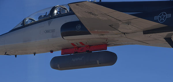
The Air Force Research Laboratory’s complementary positioning, navigation and timing (PNT) AgilePod prototype achieved three important objectives in flight tests conducted at Edwards Air Force Base Nov. 1-10, 2021.
PNT AgilePod helps develop advanced navigation technology independent of GPS, according to Maj. Andrew Cottle, Air Force Strategic Development Planning and Experimentation (SDPE) office. This technology provides reliable, resilient PNT navigation signals through alternative means, increasing mission effectiveness in scenarios where access to GPS is not guaranteed.
The test team — representing a broad base of Air Force, Navy and vendor organizations — successfully executed eight sorties aboard a T-38C aircraft, which included:
the first test of the PNT AgilePod on a high-dynamic-range platform
the first test of fully remote interfacing and alt-PNT data transmission
the first demonstration of overland/overwater transition performance.
He said the tests demonstrated the operational utility of a fused alt-PNT system incorporating multiple technologies within a single government-owned open-architecture prototype.
A PNT AgilePod attached to a T-38C successfully demonstrated remote interfacing and alt-PNT data transmission, as well as performance over land and water. (Photo: USAF/2nd Lt. Bowen Lin, 586th Flight Test Squadron)
AgilePods Designed for Flexibility
AgilePods are comprised of a series of compartments and can be configured to meet a wide variety of mission requirements for many aircraft platforms. Experimenters can fill the spaces with plug-and-play sensors they need for a mission — high-definition video, electro-optical and infrared sensors, and devices with other capabilities — including PNT.
The AgilePod has an open hardware architecture. For the complementary PNT prototype, it was combined with an open software architecture that allows a wide variety of alternative PNT technology to integrate and pass information. These capabilities enable rapid integration of sensor technologies through standardized software and hardware interfaces, allowing the pod to seamlessly integrate on platforms that leverage the standard architectures.
In this way, one pod can perform hundreds of different mission sets with additional benefits of cost savings and increased sustainability, Cottle said.
The project directly supports the AFRL PNT Enterprise and the Air Force PNT Cross-Functional Team as they work to ensure reliable navigation within GPS-contested operational scenarios critical to the success of future Air and Space Force missions.
A PNT AgilePod attached to a T-38C successfully demonstrated remote interfacing and alt-PNT data transmission, as well as performance over land and water. (Photo: USAF/2nd Lt. Bowen Lin, 586th Flight Test Squadron)
The NTS-3 experimental satellite will be launched in 2023, according to reports from C4ISRNET and Space News. The United States military will use the satellite for positioning, navigation and timing (PNT) as a supplement to GPS.
The satellite was originally set to launch in 2022.
The Air Force Research Laboratory (AFRL) plans to use the additional time to reduce risks and conduct more ground testing.
Navigation Technology Satellite 3 will help guide future GPS satellites, a priority area for the military as the technology has become easier to spoof and jam. Among other features, NTS-3 will have steerable beams for regional coverage and a software-defined payload that can be reprogrammed on orbit.
AFRL discussed the delay in a media roundtable held Wednesday, reports C4ISRNET. AFRL Commander Brig. Gen. Heather Pringle said that shift was out of the lab’s control since the satellite will launch as a rideshare with a U.S. Space Force payload, and that launch had been pushed back.
AFRL plans to experiment with the satellite in geosynchronous orbit for one year, testing PNT signals and architectures as well as ground-based command and control systems and software-defined radios. Following testing, NTS-3 will transition to the U.S. Space Force and integrate into the service’s other PNT capabilities.
THOR stands for Tactical High-power Operational Responder, a counter-swarm electromagnetic weapon for airbase defense. Although AFRL’s THOR is not a hammer-wielding god associated with thunder and lightning, the system provides non-kinetic defeat of multiple targets. It operates from ground power and uses energy to disable drones.
The THOR drone deterrent designed by the Air Force Research Laboratory. (Photo: AFRL)
“THOR is essentially a high-powered electromagnetic source that we put together to specifically defeat drones,” said Stephen Langdon, chief of the High-Powered Microwave Technologies Branch of AFRL’s Directed Energy Directorate.
AFRL is located at Kirtland Air Force Base, New Mexico. A demonstration system has been built and tested on military test ranges near the base, where it has successfully engaged multiple targets. Further testing against a larger set of drone types in swarming configurations is being planned.
THOR stores in a 20-foot transport container, which can be transported in a C-130 aircraft. The system can be set up within three hours and has a user interface that requires little training.
The technology, which cost roughly $15 million to develop, uses high-power electromagnetics to counter electronic effect. When a target is identified, the silent weapon discharges with nearly instantaneous impact.
With much of the necessary basic research previously completed at AFRL, THOR was rapidly developed and tested in 18 months.
Although there are other drone defensive systems available, including guns, nets and laser systems, THOR will most likely to extend the engagement range to effect and decrease the engagement time over the other deterrent devices.
Langdon said the THOR team hopes to transfer the technology to a System Program Office soon in order to get it into the hands of U.S. warfighters as soon as possible.
AFRL exhibited THOR at the 2019 Air Force Association Air, Space and Cyber Conference at the Gaylord National Resort and Convention Center, located just across the Potomac River from Washington, D.C. and Virginia, Sept. 16-18.
The U.S. Air Force will load a new signal feature, designed to make spoofing detectable, aboard a satellite that will broadcast it from space as a security overlay for the GPS L1C signal, but not until 2022 at the earliest.
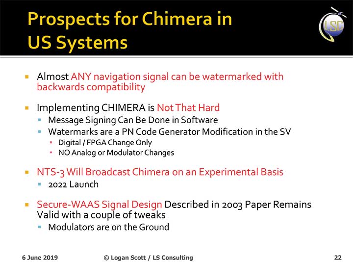
The Chips Message Robust Authentication (Chimera) is now in testing under the auspices of the Air Force Research Laboratory (AFRL), getting ready to fly on the Navigation Technology Satellite 3 (NTS-3), which will trial a number of new PNT techniques and technologies.
Chimera inserts encrypted digital signatures and watermarks within the L1C signal. A GPS receiver with the requisite additional capability for this purpose can then detect whether the signal is real or fake and also authenticate the location of a GPS receiver that is remotely located.
This key feature could provide a defense against hacking by blocking access from anyone unable to prove they are at an anticipated or licensed site. Hacking, of course, is a growing threat to all sorts of infrastructure: financial, security, utility grid and more.
Presentation slide from PNT Advisory Board briefing by Logan Scott.
Consultant Logan Scott first proposed the Chimera technology in 2003, when he affirmed that “Some of the spoofing detection measures in wide use offer a false sense of security. Authenticatable signal architectures are needed.” In June, he made a presentation to the PNT Advisory Board: “The Role of Civil Signal Authentication in Trustable Systems.” The two slides accompanying this article appeared in that presentation.
“Chimera represents a fundamental paradigm shift in PVT security paradigms,” Scott related in a subsequent conversation. “Trust takes time and memory on a personal level and, in this case, in GNSS signals, too.
“You don’t trust somebody as soon as you meet them. Over a period of time, you get to know them. If you can’t remember anything, you can’t develop trust either.”
“In the GNSS world, there are a lot of applications where you don’t need output in real time,” Scott said. “For example, to align an inertial. The inertial provides the real-time aspect. You don’t want to send anything to the IMU that is factually incorrect. When building to aid inertial, I can afford to have a delay from real time as long as I tell it where it was 10 seconds ago. The power of that is, if I don’t have to give real-time output, I can ponder and think about things.
“If a spoofer attacks, there’s an evolution that happens there. If I, as the receiver, can see the developing scenario, and how it starts to look at little screwy, I can stop and not send anything to the IMU that might corrupt it.”
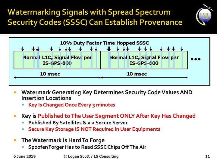
How It Works. The core concept of Chimera involves the satellites sending encrypted watermarks, encoded into the signal by the satellite. After a slight delay, the satellite sends the key used to generate those encrypted watermarks. Once a key is sent, the system changes the key.
Since the receiver has already recorded the signal with its watermarks before the key is sent, spoofers cannot know the correct key ahead of time, in time to insert correct watermarks of their own. This means that any spoofed signals can be easily spotted: either the subsequent key won’t match up with the spoofed watermarks, or there will be no watermarks at all.
“Another reason it’s hard for someone to generate these watermarks on their own is because the signal is buried below the noise,” added Scott. “The watermarks are hidden.”
A number of different time delays between signal and key are possible within this concept and within the general set-up of GPS. Scott and the AFRL have, for various practical reasons, provisionally settled on a 6-second delay on the fast watermark channel and a 3-minute delay for the slow watermark channel.
The signal enhancement could be incorporated into the Wide Area Augmentation System (WAAS). This has yet to be fully determined, but this route would lead to a faster implementation of Chimera. Scott thinks that going the WAAS route could bring Chimera capability into action within two years.
The AFRL, however, is looking at a much longer timeline. The NTS-3 satellite, where it first intends to test Chimera, will not launch until 2022 — three years hence. And that’s only a test, not an enactment or a system-wide implementation.
Slide: Logan Scott
Verification. One key benefit for commercial entities, particularly those in financial infrastructure and other systems that increasingly fall victim to hacking, is that Chimera gives them the ability to verify customers’ or partners’ locations before granting any kind of access. The customer’s or other erstwhile user’s GPS receiver would record the full signal, including the watermarks, and transmit that data to the company, entity or data center needing location verification, before the keys are published. Each combination of watermarks and signals is unique to the place where it was recorded, thus it is possible to tell whether the user is actually where they say they are, or in an authorized or pre-identified location before granting access or accepting further input (such as commands).
Scott claims that Chimera affords a 99.9% probability of detecting spoofers. “I have a 99.9% chance of detecting that the watermark is not there, because they don’t know how to generate it. This is based on how you’re processing the signal. It’s designed to be very flexible in how the receiver uses the signal.”
Just One Problem. Receiver manufacturers will have to develop new Chimera-capable receivers, and customers will have to buy them. An additional cost for the added processing, above and beyond that required for normal GPS operation, is unavoidable.
And a Hiccup. Chimera, while an acronym, is as a name perhaps not a totally felicitous choice. In Greek mythology, the chimera is a fire-breathing female monster with a lion’s head, a goat’s body, and a serpent’s tail. These historic ancestors have evolved into the word’s more current use: a thing that is hoped or wished for but that is in fact illusory or impossible to achieve.
AFRL Wants Your Opinion. The Air Force Research Laboratory seeks feedback from the PNT community on the Chimera enhancement for the L1C signal. The specification is here. And, you can download a comment form
The Ohio Unmanned Aircraft Systems Center and the Air Force Research Laboratory (AFRL) will soon begin testing groundbreaking aviation technology at the Springfield-Beckley Municipal Airport.
Ohio Governor Mike DeWine, Lt. Governor Jon Husted and Major General William Cooley, commander of the Air Force Research Laboratory (AFRL) made the announcement April 26 at Wright Patterson Air Force Base.
Skyvision was developed in a collaboration between AFRL and the State of Ohio. AFRL and a delegation of Ohio UAS industry experts will showcase the SkyVision system at AUVSI Xponential in Chicago April 30 to May 2 (Booth 4226).
The SkyVision technology safely, accurately and effectively allows drones to detect and avoid other aircraft while in flight. SkyVision can be described as an air traffic control system for drones.
Inside the Skyvision RV. (Photo: Ohio UAS Center)
The validation of this aviation technology led the FAA to grant AFRL a certificate of authorization to test defense-related drone technology without reliance on a visual observer or chase aircraft.
Typically, drones can only fly within the uninterrupted line of sight of the person operating the UAS, but this special waiver allows AFRL and the Ohio UAS Center, which is part of the Ohio Department of Transportation’s DriveOhio Initiative, to use SkyVision to test drones beyond the visual line of sight (BVLOS) within a 200-square-mile parcel of unrestricted airspace near the Springfield-Beckley Municipal Airport.
“As our country steps more and more into the unmanned age of flight, this technology is on the forefront of the aviation frontier, making Ohio a critical national asset for the research and development of UAS technology,” said Governor DeWine. “This also opens the door for commercial companies to work with Ohio, AFRL, and the FAA to test their own UAS-related
technology using our SkyVision detection system. This is a major step in revolutionizing the transportation industry, with Ohio leading the way in aerospace, defense, and aviation innovation.”
“This is an important development in the progression of unmanned aircraft,” said Major General William Cooley, Commander of AFRL at Wright-Patterson Air Force Base. “This waiver provides the latitude to test beyond-line-of-sight keeping AFRL on the leading edge of world-class research and accelerates the delivery of technology that makes a difference to the warfighter.”
“By enabling our lower-altitude airspace for advanced modes of transportation, we’ll be able to facilitate new opportunities around advanced autonomous aircraft research and development,” said Lt. Governor Husted. “This will bring investment to Ohio and solidifies Ohio’s position as a world- recognized leader in aviation technology.”
Ohio’s SkyVision detection system could potentially be used by the state to develop and test UAS technology to assist citizens in the event of a natural disaster or to significantly enhance the capability of search and rescue teams to find missing persons in time-critical situations. Commercial companies, such as those looking to use drones to survey damaged infrastructure or hoping to launch drone commerce operations, will also now have incentive to move to Ohio to test their own UAS technology.
VyrtX, a company based out of Dayton, is among the first companies that has committed to expand into Springfield to work with AFRL and the Ohio UAS Center. VyrtX is currently developing technology for the potential transport of organ donations between hospitals for transplant surgeries.
UAS test flights will take place at heights ranging from 1,000 feet above ground to 10,000 feet mean sea level. Air traffic control experts from the Ohio UAS Center will operate SkyVision during each flight. The SkyVision detection system is located within a mobile unit so that it can be flexibly placed in optimum positions for each flight.
“Today’s announcement comes after years of hard work and collaboration among an incredible group of partners,” said Jeff Hoagland, President and CEO of the Dayton Development Coalition. “AFRL and Ohio had a bold vision to bring UAS into the national airspace for true beyond-visual- line-of-sight flight. The work done here will shape the industry for years to come.”
The State of Ohio and AFRL both invested a combined $5 million for the research and development of SkyVision.
Supported by the Ohio Department of Transportation, DriveOhio works to ensure Ohio’s regulatory environment and public policies are conducive to the development of the infrastructure and technologies needed for smart mobility.