An aviation industry coalition is voicing concern to Transport Canada about elements of a proposed mandate that will require aircraft flying in Canada to be equipped with the Automatic Dependent Surveillance-Broadcast (ADS-B), also called the Next Generation Air Transportation System, or NextGen.
ADS-B uses GNSS technology to calculate an airplane’s precise location, speed and direction. This information is transmitted twice per second, providing greater situational awareness for air traffic controllers.
The mandate in Canada requires aircraft to implement 1090ES ADS-B in two phases over the next four to five years. It takes effect for Class A and B Canadian airspace (above 12,500 feet) on Feb. 23, 2023, and Class C, D, and E airspace no earlier than 2026.
Space-Based Transceivers
The proposed mandate will also require antennas capable of communicating with both ground-based and space-based transceivers (referred to as antenna diversity). The United States uses ground-based ADS-B stations, which are confined to line-of-sight reception between the aircraft and ground receivers.
Space-based ADS-B does not have this limitation, but requires antennas on top of the aircraft to provide the required fidelity to allow for air traffic separation.
“This would constitute an equipage mandate for most U.S. operators wanting to fly to Canada, most of which have recently equipped to meet U.S. requirements,” said Jim McClay, director of airspace, air traffic and security for the Aircraft Owners and Pilots Association (AOPA). “To comply, many operators will need to install new antennas on top of their aircraft as well as possibly replace their ADS-B units. The costs of complying will be significant and would be borne only by aircraft owners.”
A recent AOPA survey of members in border states revealed that most U.S. operators are unaware of the coming mandate and almost half of respondents who regularly fly to Canada indicated they would cease flying to Canada altogether in the face of the mandate.
Lack of Installers
The industry coalition also agrees that it is highly doubtful that there are enough avionics installers to complete the needed upgrades in time to meet the mandate’s deadlines.
“Due to these concerns, AOPA is urging a delay of the Nav Canada equipage mandate until a determination can be made on the cost impact to purchase and install the required equipment and discussions on potential alternative solutions are held,” McClay said.
Other Countries
According to Nav Canada, the equipage requirements of Canada’s ADS-B mandate are in line with those of a growing number of other countries in the world. “The adoption of satellite-based surveillance technology ensures long-term alignment with the global aviation system,” the company stated. Nav Canada provides services to Canadian airspace such as air traffic control and weather advisories.
Members of the coalition include the Canadian Owners and Pilots Association, General Aviation Manufacturers Association, Garmin, the Canadian Business Aviation Association, AOPA and others.
Coalition members share concerns that the mandate being pursued by Nav Canada and Transport Canada does not appear to be going through the full consultative process, and will submit their concerns over the next several weeks.
Movement, closeness, privacy — many things we took for granted a few months ago have become luxuries after the onset of COVID-19. To get an understanding of the scale and impact of the virus, we can look at global movement trends of people and merchandise using GNSS technology.
Marine
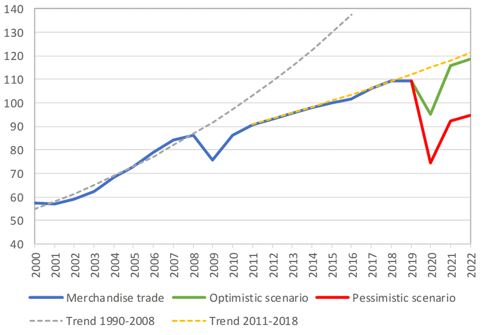
Before the coronavirus pandemic, globalization seemed to be increasing endlessly. Now, we face new trade restrictions, protectionist policies, and a global economic downturn that threatens to stunt growth for years to come.
In April, the World Trade Organization (WTO) forecast that global trade would fall by between 13% and 32% in 2020, surpassing the “great trade collapse” of 2009 spurred by the global financial crisis.
However, the situation isn’t completely bleak. According to a recent Tradeshift report, global trade decreased by 14.8% in the second quarter of 2020, putting us on the optimistic end of the WTO estimate. June saw a rise in trade activity, suggesting that we may be recovering from the initial effects of the pandemic.
Cargo vessels, tankers, tugs, and other kinds of commercial ships are equipped with satellite navigation devices that can receive information from GNSS satellites to compute precise location and time. Maritime tracking insights obtained via GNSS/GPS signals are a great method for measuring the impact of the coronavirus on trade.
Photo: shaunl/E+/Getty Images
GPS data from MarineTraffic shows that ship arrivals decreased in nearly all of China’s ports from January to March.
Source: MarineTraffic
Just as trade shipping began to pick up in China, the United States and Europe were hit hard by the pandemic. However, shipments have now begun to climb worldwide to compensate for cancellations earlier this year.
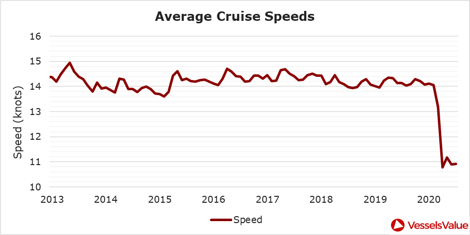
The cruise industry, on the other hand, shows little indication of recovery. Cruises were the fastest growing segment of the travel industry over the past five years — until the pandemic hit.
On June 19, the Cruise Line International Association (CLIA) and Centers for Disease Control and Prevention (CDC) announced a “no sail order” for cruise ships. The order has been extended through Sept. 30. Furthermore, the cruise industry’s reputation has been damaged by multiple outbreaks on ships, most recently the MS Roald Amundsen of Norway. At least 43 people were infected on the MS Roald Amundsen, and Norway has now banned cruise ships with more than 100 passengers from disembarking at Norwegian ports.
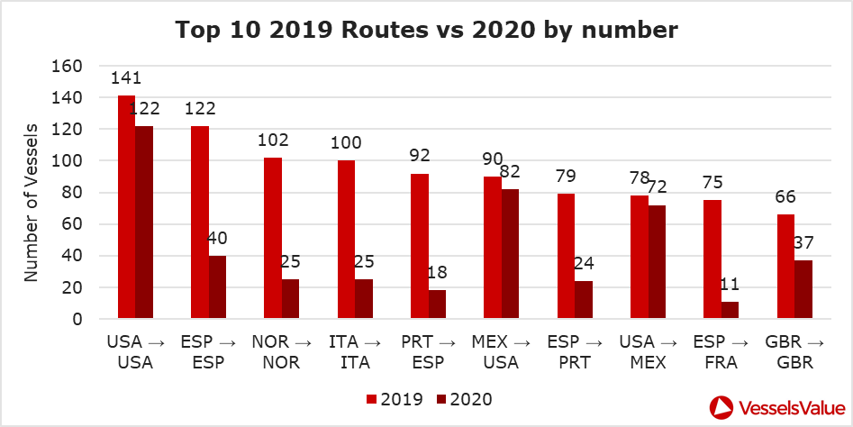
Maritime intelligence company VesselsValue is using AIS data to map cruise ship activity throughout the pandemic. They have noted that while cruise ships typically sail at 13.5 knots to 15 knots, average speed has dropped to 11 knots in 2020 as ships attempt to lower fuel costs. Port-to-port sailings have declined for the 10 most popular cruise routes.
Source: VesselsValueSource: VesselsValue
Most of the port-to-port sailings that constitute the 2020 columns in the above graph actually represent ships being repositioned for a break in service, also called a “layup.” Layups can cost cruise companies millions of dollars per month, but with no sail orders and port closures, they are a necessary expense.
According to the Oxford COVID-19 Government Response Tracker, a real-time monitoring system that evaluates government policies, April marked the strictest lockdown measures across all 133 available coastal countries. The tracker uses a stringency index between 0 and 100 based on national containment and closure policies.
Source: Oxford COVID-19 Government Response Tracker
Air
Commercial air traffic has decreased as well. According to GPS flight tracking service Flightradar24, the number of global daily flights was slashed by nearly two thirds between March and April. While there were 15,012 flights in the air at 15:00 UTC on March 7, there were only 5,275 at the same time on April 7.
Global air traffic March 7, 2020. (Source: Flightradar24)Global air traffic April 7, 2020. (Source: Flightradar24)
There were 55% fewer flights in the last week of March 2020 than in the last week of March 2019. While all types of air traffic have been reduced for fears of infection, the coronavirus has especially decimated demand for passenger flights. Passenger airlines across the world have canceled flights and cut capacity for the foreseeable future. Some passenger airlines have even switched to transporting cargo in a desperate attempt to avoid bankruptcy.
Looking at regional tracking data can further illuminate the impact of COVID-19 on air travel. Travel restrictions and border closures were enacted en masse in late March, though some nations adopted more stringent policies than others.
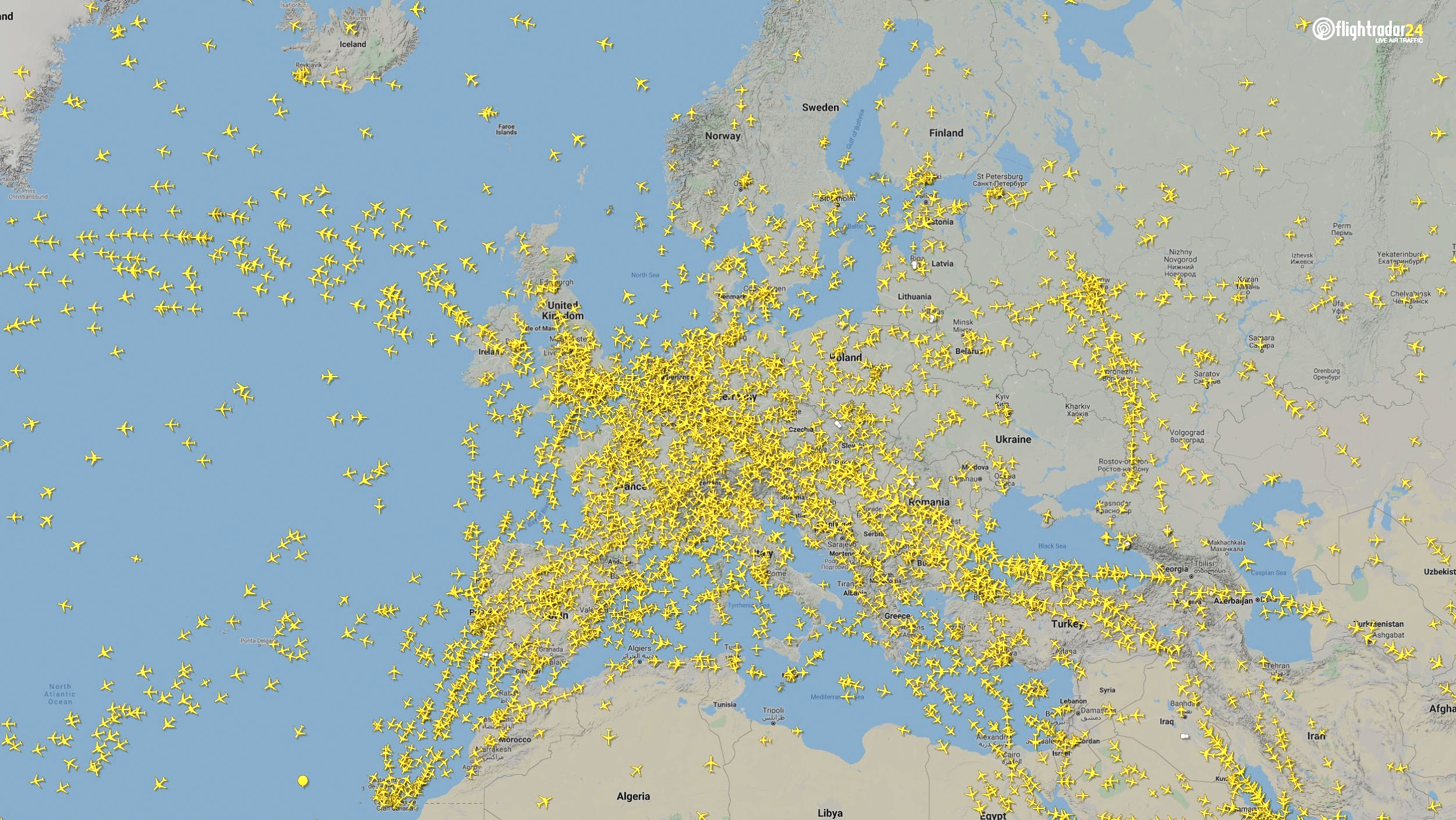
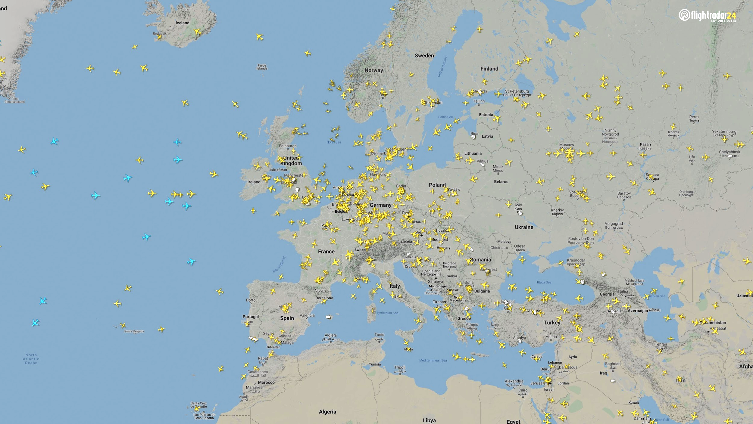
Europe
The number of flights in Europe has plummeted since the onset of the coronavirus pandemic. There were 2,400 fewer flights in Europe on April 7 than March 7.
Air traffic over Europe March 7, 2020. (Source: Flightradar24)Air traffic over Europe April 7, 2020. (Source: Flightradar24)
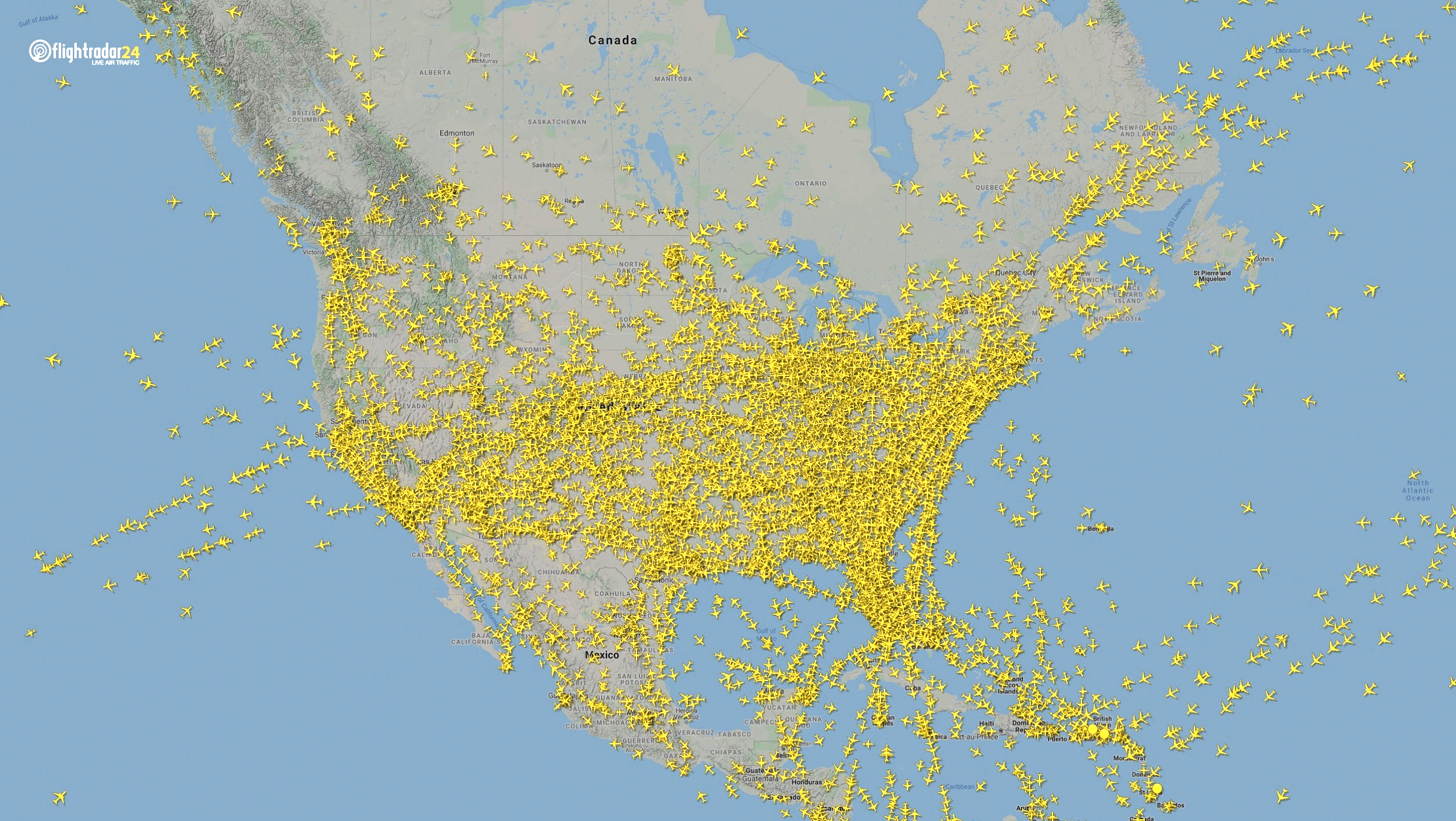
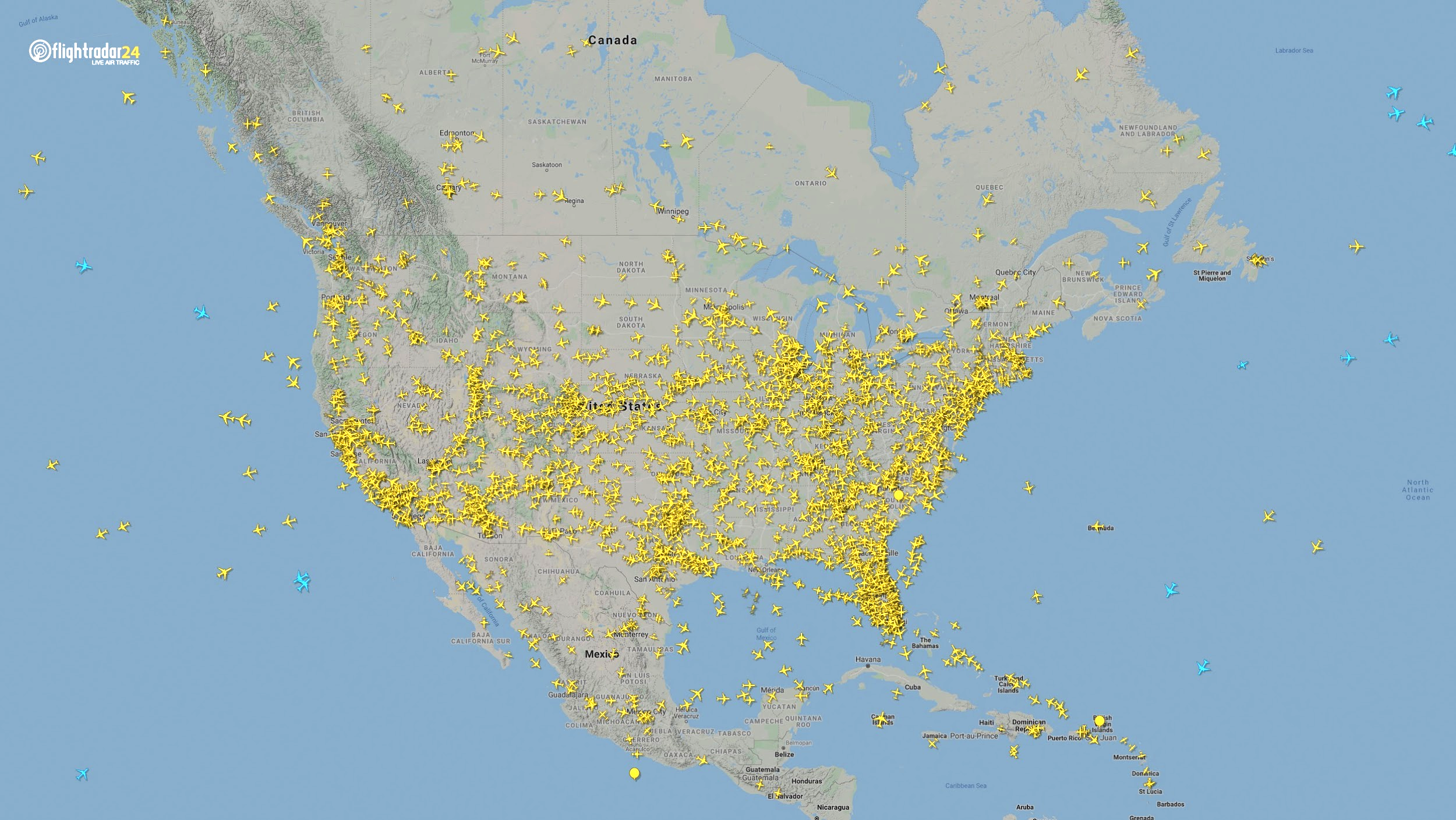
North America
Though air travel has been disrupted across North America, the United States remains significantly more busy than its neighbors. The March 7 image shows 8,400 flights while the April 7 image shows 2,950 flights, most of them concentrated over the United States.
Air traffic over North America March 7, 2020. (Source: Flightradar24)Air traffic over North America April 7, 2020. (Source: Flightradar24)
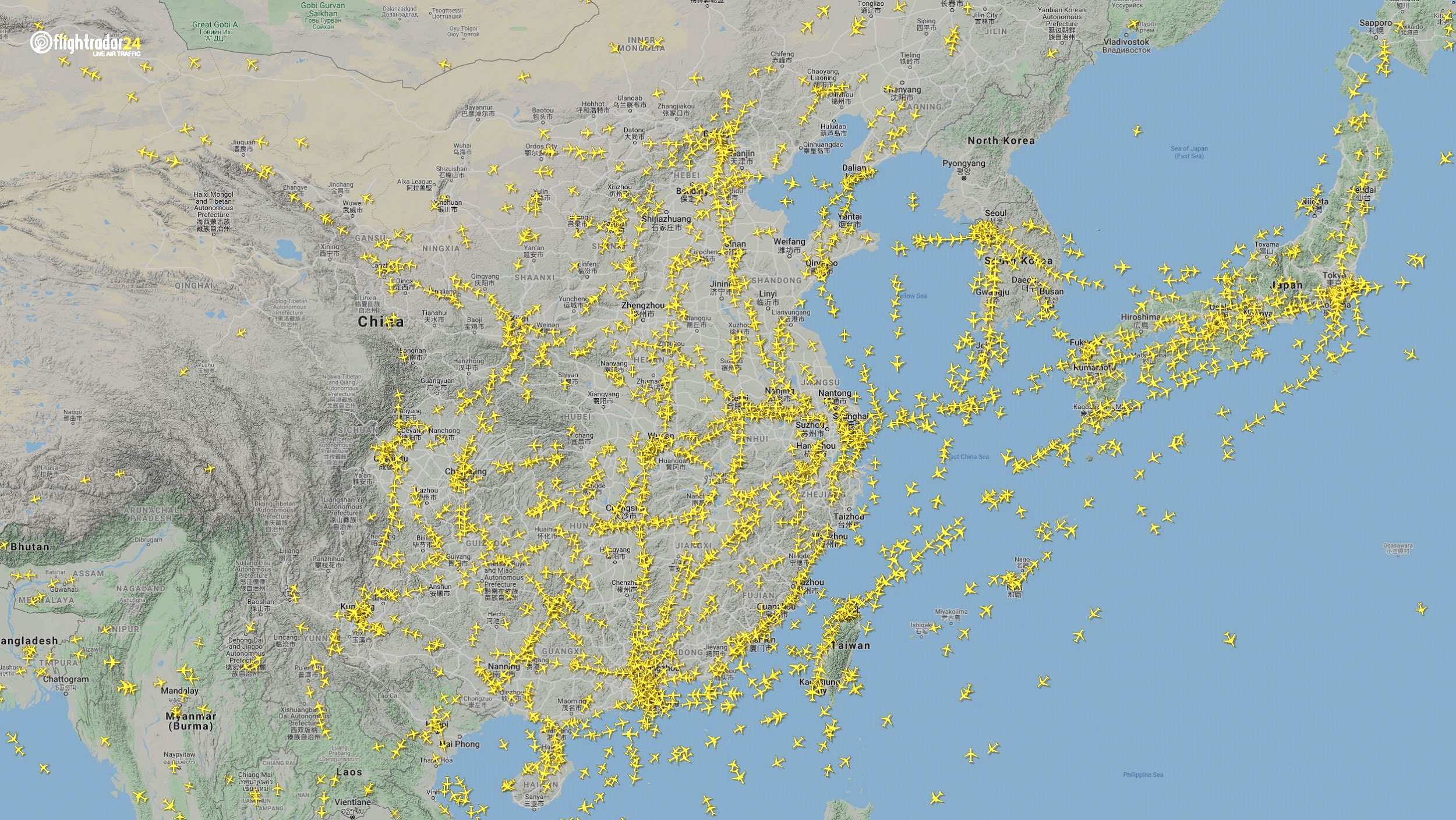
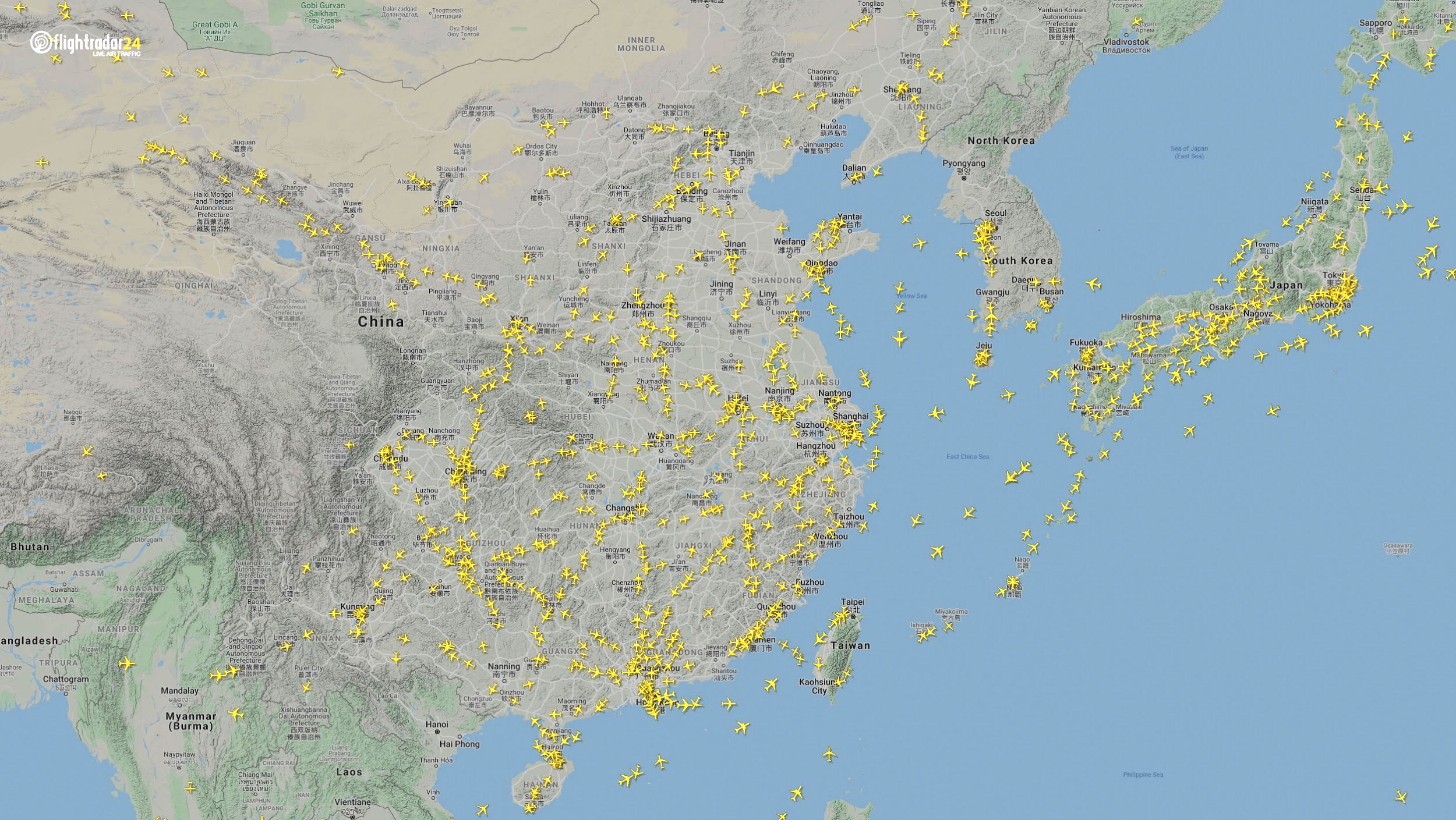
East Asia
The decrease in air traffic over East Asia has been severe and persistent. Since China and its neighbors began to experience a trade downturn as early as the third week of January, we can compare January 7 to April 7 to capture the effects of the coronavirus. As of late July, air traffic at China’s busiest airports was still down approximately 60% from normal levels.
Air traffic over East Asia January 7. (Source: Flightradar24)Air traffic over East Asia April 7. (Source: Flightradar24)
Ground
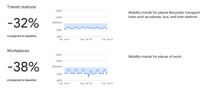
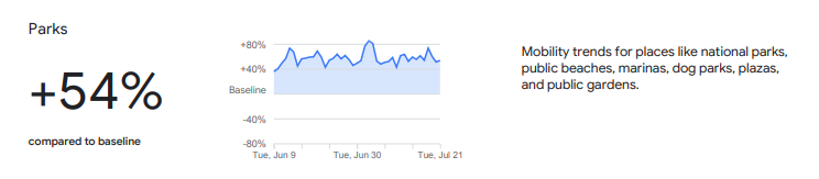
Google has released — and continues to update — a series of community mobility reports that chart movement trends in public spaces. The reports are a compilation of GPS data for Google users across the world.
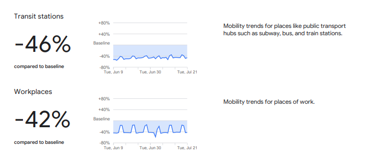
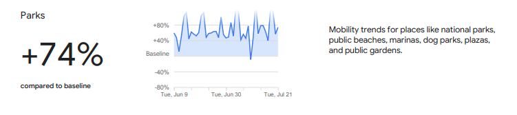
Mobility changes are particularly stark for regions hit hard by the coronavirus. New York state showed a 46% reduction in visits to transit stations and a 42% reduction in visits to workplaces in June and July compared to pre-pandemic baseline levels. New Yorkers are also visiting parks 74% more often.
Screenshot: GoogleScreenshot: Google
Trends in the United States as a whole are also dramatic.
Screenshot: GoogleScreenshot: Google
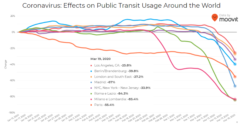
Israeli journey-planning app Moovit is using mobile phone data to document trends in public transit ridership. Many of the world’s largest metropolitan cities experienced a steep decline in ridership between mid-January and late March. Millions of people that rely on mass transit have had to cope with cumbersome rules and the danger of catching the virus itself. Efforts to reduce overcrowding on trains and buses have translated into reduced capacity requirements and therefore, lengthy wait times. The rise of remote work has also lowered public transit ridership.
Screenshot: Moovit
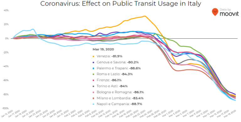
Italy was hit particularly hard – and early – by the pandemic. Two large outbreaks occurred in Northern Italy in late February, prompting widespread closures and government-mandated quarantines in Lombardy and 14 neighboring provinces. Public transit ridership plummeted when the quarantine took effect in early March.
Screenshot: Moovit
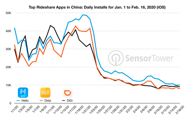
Usage of GPS-reliant ride-hailing apps has also dropped severely. Daily installs of China’s three biggest ride-hailing apps were down 75% the week of February 10 compared to the same week in 2019.
Source: Sensor Tower
American ride-hailing giants Uber and Lyft have seen similar losses. However, business for food delivery apps like Uber Eats and Grubhub are on the rise as more people stay home instead of grocery shopping.
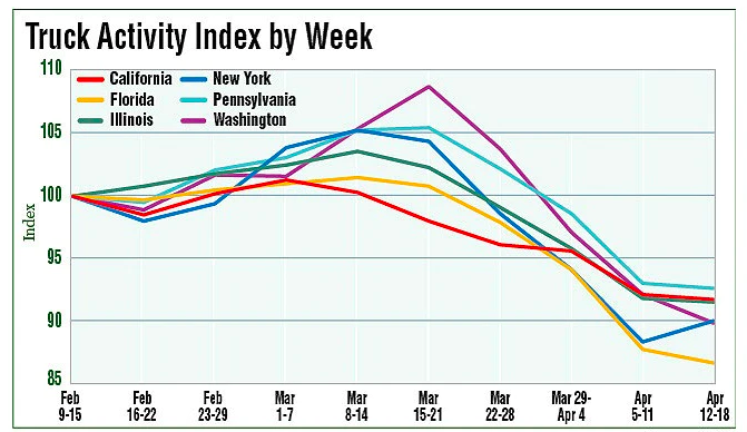
The impacts of COVID-19 have been less severe — but still significant — for the trucking industry. The U.S. trucking industry is an economic powerhouse, typically generating over 700 billion in annual revenue and transporting 72.5% of American freight. The American Transportation Research Institute generated a truck activity index based on GPS data across six states from the week of February 9 to the week of February 12. The data shows an initial spike in trucking operations due to increased demand for consumer goods and medical supplies. However, as stay-at-home orders and restrictions ceased business operations across the country, truck activity declined.
Source: American Transportation Research Institute
Coronavirus safety restrictions adopted by countries across the world have generally begun to loosen up, for better or for worse. It will be interesting to see how the coming months unfold through the lens of GNSS data.
Roi Mitt works for Regulus Cyber, a company researching GPS cybersecurity and offering various software products to protect the integrity, reliability and security of GNSS devices. The company’s products are designed for multiple industries using GPS-based time and location, in order to ensure a future in which GNSS technology is safe and reliable to use.
Spire Global has released the company’s first product from Spire Aviation with the launch of its new AirSafe API (application program interface).
Spire Aviation’s AirSafe product uses low-Earth orbit ADS-B technology combined with ground-based collection to provide detail on global aircraft position reports for the world’s aircraft fleet operations.
With more than 70 million position reports every day and growing, AirSafe is positioned to provide best-in-class data over land and the world’s oceans.
The AirSafe product solves the industry’s need for flight tracking data covering both land and oceans at a competitive cost, illuminating trends in aircraft operations, the company said.
Airsafe enables a fixed-based operator to analyze historical data to safely increase productivity by better positioning resources in the future, and then using real-time data to create a proactive alerting system for diversion or air turnbacks.
Spire Aviation is building towards full surveillance of all remote areas of the globe and continues to grow its satellite constellation. Spire’s aggressive roadmap includes launch campaigns to ultimately provide an equatorial ICAO 4D/15 compliant method of aircraft tracking (+/- 15 degrees latitude) and global coverage enabled by inter-satellite links. These satellite launches will produce the an advanced nanosatellite constellation for aviation ADS-B and aviation weather forecasting.
Spire AirSafe also offers Spire’s proprietary weather forecasting products, enabling customers to benefit from fused aircraft location positional data and global winds aloft (Every 1,000 feet MSL) and clear air turbulence forecast.
Learn more about the benefits of working with Global ADS-B data and Spire’s Aviation Weather Forecast during an upcoming webinar.
The European Union (EU) project BLUEGNSS has been developing GNSS applications in selected European airports to increase safety and airport accessibility, according to the European Commission’s Community Research and Development Information Service (CORDIS).
BLUEGNSS’s focus has been on advancing the adoption of the Galileo system in Greece, Italy, Cyprus and Malta. The four countries together form the Blue Med functional airspace block (FAB): airspace in which air traffic is managed irrespective of national boundaries. Blue Med is one of the nine FABs formed in Europe to reduce the fragmentation of the European air traffic network.
Three-dimensional GNSS approaches are being designed for 11 airports in the Blue Med FAB: four each in Greece and Italy, two in Cyprus and one in Malta.
The primary aim is to harmonize the implementation of required navigation performance approaches among the four countries, CORDIS said. This will enable aircraft to fly along precise flight paths with greater accuracy, and will make it possible to pinpoint aircraft position with precision and integrity.
Three new procedures. So far, substantial progress has been made towards safety and airport accessibility in the target countries. Since the beginning of 2018, three new GNSS procedures have been validated for Italian airports Cuneo, Lamezia and Parma, followed by another two for Larnaca and Paphos in Cyprus.
The poor weather conditions under which the Cyprus GNSS approaches were validated served to demonstrate the benefits of GNSS vertical guidance. Since its launch in 2016, BLUEGNSS has designed and validated 14 GNSS procedures.
Augmented performance of Galileo has been achieved through the European Geostationary Navigation Overlay Service (EGNOS). EGNOS is a satellite-based augmentation system that improves GNSS positioning. Its three satellites and network of more than 39 reference stations in 24 countries enable it to provide greater accuracy than Galileo alone.
EGNOS’s safety advantages and lower investment costs greatly benefit small and regional airports, which usually can’t afford the high costs of installing and maintaining ground-based navigation aids.
For this reason, BLUEGNSS has promoted its use in this geographically challenging Mediterranean region.
“The southeast Mediterranean region lacks full EGNOS coverage,” said GNSS expert Patrizio Vanni of ENAV S.p.A., project coordinator and Italy’s air navigation service provider. “To make things even more challenging, each airport involved in the project presents a very different operational environment.”
The project hasn’t only focused on designing and validating GNSS approaches at airports where no such procedures have been available up to now. It has also provided the necessary training and monitoring to support implementation by the Blue Med FAB countries.
Now close to completion, BLUEGNSS (Promoting EGNSS Operational Adoption in Blue Med FAB) is the first project of its kind to be coordinated at FAB level. It may serve as a catalyst to spread required navigation performance approach know-how in the region and beyond, to the whole of Europe.
Simulyze Inc., a provider of operational intelligence technology and applications that empower both federal and commercial organizations, today announced its participation as a founding member of the newly launched Global UTM (Unmanned Aircraft Systems Traffic Management) Standardization Group, based in Geneva, Switzerland.
The group’s founding members include regulators, air navigation service providers, drone manufacturers, drone operators, infrastructure service providers and academic experts from 10 nations.
A not-for-profit stakeholder organization, the Global UTM Standardization Group will work on drafting and distributing an interoperability blueprint for traffic management of unmanned aircraft systems (UAS). The global initiative is intended to provide input on a harmonized, scalable and future-proof system that can be quickly defined and implemented by regulators worldwide.
“For unmanned aircraft to be truly commercially viable, a common global architecture and set of operational standards and practices need to be developed to ensure the safe integration of drones into international airspace,” said Kevin Gallagher, CEO and president of Simulyze. “By fostering international cooperation and sharing expertise amongst UAS stakeholders, the Global UTM Standardization Group will play a key role in defining the best way forward for UAS. We are honored to be a part of this prestigious group of thought leaders around the world and look forward to collaborating closely to harmonize air traffic management systems.”
The Global UTM Standardization Group was launched on April 27 at the first European UTM Day held in Geneva, Switzerland. More than 60 organizations from the U.S., Europe and China participated in the day’s activities, which included discussions about what actions need to be taken to safely and efficiently integrate remotely piloted and autonomous aircraft into national airspace systems.
Simulyze’s proprietary operational intelligence platform powers Mission Insight, the company’s packaged, commercial off-the-shelf application that processes and analyzes large streams of data from disparate sources in real-time. It provides UAS operators with a common operating picture in a customized graphical interface.
On April 19, Mission Insight was successfully deployed in support of the National Aeronautical and Space Administration’s (NASA) Technical Capability Level 1 UAS testing. In the first and largest demonstration of its kind, NASA and operators from six UAS test sites across the country flew 22 drones simultaneously during a three-hour test to assess line-of-sight, rural operations of NASA’s UTM research platform.
Simulyze directly supported operations at two UAS test sites and provided simulated flights. Mission Insight was the only enterprise-level solution used that integrated all aspects of multiple flight operations into a single interface.
Aireon LLC, developer of a space-based ADS-B global air traffic surveillance system, is planning the Aireon Aircraft Locating and Emergency Response Tracking (Aireon ALERT) service, a global emergency tracking service that will be provided free of charge to the aviation community beginning in 2017. The Aireon ALERT service will allow rescue agencies to request the location and last flight track of any 1090-MHz ADS-B equipped aircraft flying in airspace currently without surveillance.
“A comprehensive, global aircraft tracking solution is essential in emergency situations, as evidenced by MH370 earlier this year and Air France 447 in 2009,” said Don Thoma, president and CEO, Aireon. “Aireon is being deployed to improve the efficiency and safety of aircraft operations in oceanic and unsurveilled airspace. The same technology behind these efficiency and safety gains can also make a significant difference in providing quick, accurate information in emergency situations. With one global view of ADS-B equipped aircraft, Aireon ALERT will provide accurate and real-time tracking data immediately to authorized search-and-rescue operations, without requiring airlines to equip aircraft with new avionics or the ANSPs and authorities to deploy new systems.”
Aireon is deploying a global space-based ADS-B surveillance capability providing direct air traffic controller visibility of flights operating in oceanic or remote airspace, focused on improving the efficiency and safety of aircraft operations. When Aireon is fully operational, anticipated for 2017, it will create a powerful platform capable of tracking ADS-B equipped aircraft around the globe in real time.
The Aireon ALERT service will be available soon after Aireon’s full deployment and will be provided through a 24/7 application and emergency call center. Historical track data will be available to pre-authorized users, including ANSPs, airlines, and search-and-rescue authorities, through Aireon ALERT soon after controller communications are lost with an aircraft. The system can also provide real-time tracking of aircraft in distress, provided ADS-B transmissions are still operational.
“Tracking of aircraft in emergency and search-and-rescue situations is a complex issue,” said Cyriel Kronenburg, vice president sales and marketing for Aireon. “We plan to engage the various aviation stakeholders including the airlines, ANSPs, regulators, and search-and-rescue organizations over the next 12 months to define the technical, operational, and legal details of providing this data in emergency situations.”
“We anticipate support from the world’s airlines for the approach taken by Aireon for emergency tracking,” said John Crichton, president and CEO of NAV CANADA. “Airlines already stand to gain over $125 million per year in fuel savings in the North Atlantic alone by using Aireon’s space-based surveillance service. The Aireon ALERT public service offers an additional benefit, free of charge, ensuring that ADS-B equipped aircraft can be tracked anywhere in the world, even in airspace managed by ANSPs that have not subscribed to the Aireon service.”
Aireon is a joint venture among Iridium Communications Inc., NAV CANADA, ENAV, IAA, and Naviair, established to launch the Aireon system by hosting ADS-B receiver payloads on Iridium NEXT, Iridium’s second-generation satellite constellation, scheduled for first launch in 2015. This new capability will extend air traffic surveillance to the entire planet and increase the safety and efficiency of air travel over oceanic and remote regions.