The agreement ensures Europe’s satellite-based augmentation continues enhancing navigation for aviation and other critical users and lowering emissions.
SES, a space solutions company, and the European Union Agency for the Space Programme (EUSPA) have announced an extension of the European Geostationary Navigation Overlay Service (EGNOS) GEO-1 satellite service agreement through 2030, with an option to extend until 2032, helping maintain high-precision navigation services for aviation and other critical users across Europe.
By improving the accuracy and integrity of satellite positioning signals, EGNOS supports aircraft in landing in low-visibility conditions, as well as planning more efficient routes, reducing fuel burn and CO₂ emissions.
At the core of the EGNOS service is Europe’s regional satellite-based augmentation system (SBAS) that improves the accuracy and reliability of GNSS signals, such as GPS. Beyond aviation, EGNOS supports maritime navigation and precision-driven agriculture, contributing to efficient operations and sustainability by reducing fuel consumption and emissions.
Under the extended GEO-1 contract, SES will continue operating an EGNOS-hosted payload on its SES-5 satellite, as well as the ground segment from its facilities in Europe.
“This extension ensures a robust EGNOS space segment, ready for the transition towards its next version and the development of new services, while safeguarding high-precision navigation for aviation and other critical users across Europe,” said Rodrigo da Costa, EUSPA executive director.
“EGNOS is a cornerstone of Europe’s aviation and broader navigation applications. The agreement underscores SES’ and EUSPA’s joint commitment to advancing satellite-based services that enable secure, reliable, and sustainable navigation solutions,” said Philippe Glaesener, senior vice president, Global Government at SES. “Thanks to the service, millions of users and operators will benefit from efficient and more reliable air transportation services across all of Europe. This commitment reflects our broader mission of delivering resilient satellite solutions for critical infrastructures.”
Ukraine has received its first Shark ultralight aircraft with electronic warfare (EW) capabilities from the Czech-Slovak company Shark.Aero, reports European Security and Technology (ES&T), a German publication. The Shark can detect and jam enemy drones and will strengthen the defense of Ukraine against Russian attacks.
The Shark’s two-seat tandem configuration was originally designed as a high-performance ultralight aircraft for civilian use. Its main features are its high speed of nearly 300 km/h and its maneuverability.
The military version of the ultralight is designed to detect and jam enemy drones. It offers the Ukrainian army a mobile, airborne defense option against loitering UAVs and reconnaissance drones.
Electronic warfare system
The first EW component suppresses GNSS navigation signals; the second suppresses video and remote control channels of enemy drones. The system is installed in a suspended container under the center of the fuselage so as not to affect the aerodynamics of the craft. From an altitude of 1800 m, the system can interfere with the operation of drones within a radius of up to 4.5 km.
A Shark representative discusses the ultralight with EW capabilities below.
Europe’s EGNOS satnav system has been providing safety-of-life services for 10 years. EGNOS, the European Geostationary Navigation Overlay Service, transmits signals from a duo of satellite transponders in geostationary orbit.
The satellite-based augmentation system (SBAS) gives additional precision to U.S. GPS signals, delivering an average precision of 1.5 meters over European territory, as much as a 10-fold improvement over unaugmented signals. EGNOS also provides confirmation of GPS signal integrity through additional messaging identifying any residual errors.
While the EGNOS Open Service has been in general operation since 2009, EGNOS began its safety-of-life service in March 2011.
The European Space Agency (ESA) designed EGNOS as the European equivalent of the U.S. Wide Area Augmentation System (WAAS), working closely with the European air traffic management agency Eurocontrol. ESA then passed EGNOS to the European GNSS Agency (GSA) to run operationally.
Guiding airliners
EGNOS’s primary customer is aircraft. Without guidance from the ground, pilots using EGNOS can confidently descend in bad weather to 60 meters’ altitude before needing to make visual contact with the tarmac.
On March 17, 2011, France’s Pau Pyrénées Airport was the first airport to use EGNOS. Today, more than 385 airports and helipads and 60 airlines across Europe use EGNOS-based LPV-200 approaches (short for Localizer Performance with Vertical guidance – 200 feet). The EGNOS service requires no ground equipment, and replaces the radio guidance beamed upward by traditional CAT I instrument landing system (ILS) infrastructure with no decrease in performance.
As of March 2021, more than 385 airports and helipads and 60 airlines across Europe are using EGNOS-based LPV-200 approaches. (Image: ESA)
Serving drones
EGNOS is now being eyed as the enabler of unmanned aerial vehicles (UAVs). The GSA has supported numerous trials of drones equipped with EGNOS as well as Galileo through its EGNSS4RPAS project. Crewed aircraft are expected to be vastly outnumbered in our skies by all kinds of UAVs, employed for everything from weather and environmental monitoring to personalized delivery services.
U-Space is Europe’s program to integrate drones into the airspace. (Image: ESA)
The traditional person-based air traffic control model will need to evolve to accommodate such a shift, based on automated monitoring, traffic management and collision avoidance. In Europe, this highly automated version of air traffic control is termed U-space.
EGNOS’s safety-of-life service is essential to making this happen, moving from today’s situation — where drones are limited to specific air corridors and line-of-sight operations — to let them roam freely but safely in busy airspace and built-up areas.
“The whole idea behind EGNOS’s safety-of-life has been to render satellite navigation sufficiently reliable for any kind of use,” explained Didier Flament, who leads ESA’s EGNOS team. “After 10 years of faultless operations, new applications are becoming plain. Drone flight is one example. EGNOS is also being evaluated for train positioning as well as assisted and autonomous automobile driving.”
EGNOS, the next generation
ESA retains responsibility for the system’s evolution, and the middle of this decade should see the debut of its new generation, EGNOS v3.
“While the current system only works with single-frequency GPS signals, EGNOS v3 will operate on a multi-frequency, multi-constellation basis, able to augment all available satellite signals in both L1 and L5 bands, including Galileo,” Didier said. “The result will be far enhanced performance and reliability.
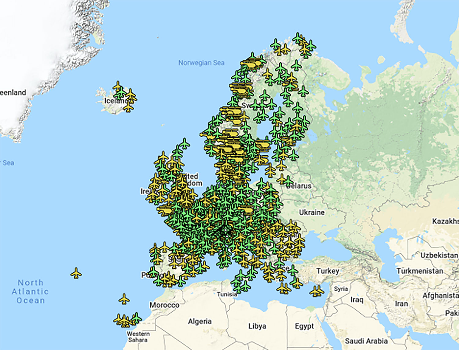
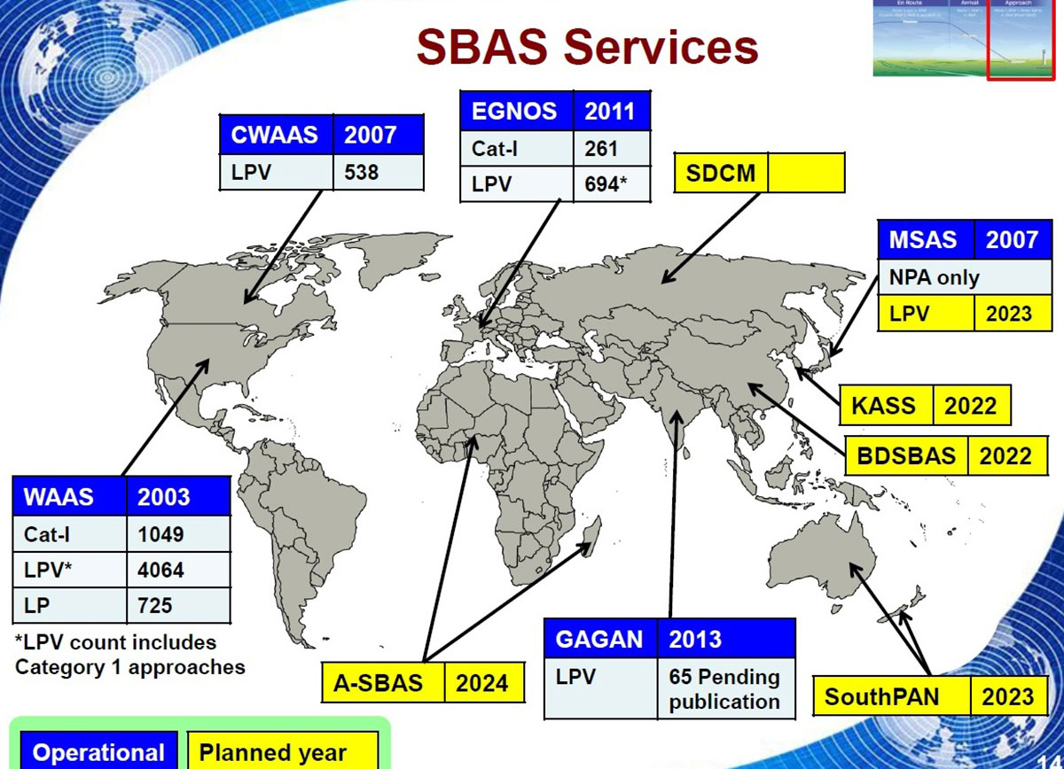
“In addition, we are working with developers of other SBAS around the globe to ensure they stay fully interoperable so for instance EGNOS-equipped aircraft can fly between continents on a seamless basis. Such interoperability, combined with the arrival of the other SBAS systems under development in other regions, will lead to a quasi-global worldwide safety-of-life service coverage in the year 2030.”
Operational and planned satellite-based augmentation systems (SBAS) around the globe. (Image: ESA)
Raytheon Intelligence & Space, a Raytheon Technologies business, delivered its 3,000th MAGR 2000-S24 GPS system to the U.S. Air Force. The MAGR2K is a secure, resilient GPS receiver that allows the warfighter to navigate the battlespace with protection against interference and jamming.
The MAGR2K is an upgrade to the legacy miniaturized airborne GPS receivers and is in service aboard 20 types of fixed-wing and rotary-wing platforms from Department of Defense and Foreign Military Sales customers.
“In the battlespace, disruptions to navigation are not an option,” said Eric Ditmars, vice president of Secure Sensor Solutions at RI&S. “Our MAGR2K GPS receivers enhance GPS acquisition and performance ensuring military forces reliable and assured GPS data they can act on. Delivery of the 3,000th unit is a significant milestone for our team.”
Raytheon Intelligence & Space continues to upgrade the MAGR2K technology to stay current with the evolving battlespace. Development is underway for the MAGR-2K-M, which uses the company’s M-code technology.
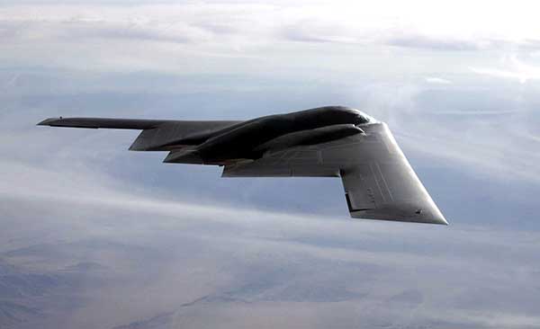
The first production readiness units are undergoing platform integration on the U.S. Air Force’s B-2 platform.
B-2 Spirit multi-role bomber capable of delivering both conventional and nuclear munitions. In December 2017, the Air Force completed a series of successful flight tests of M-code GPS using a Raytheon Company receiver on board a B-2 Spirit at Edwards Air Force Base, California. (Photo: U.S. Air Force/Bobby Garcia)
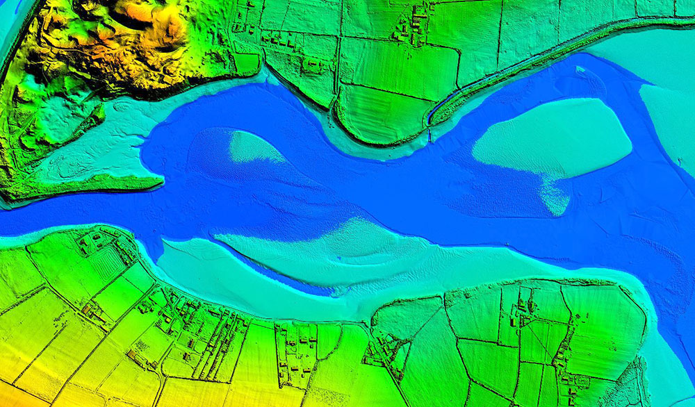
Dundrum Bay on the coast of Northern Ireland is captured by a mapping airplane in a project to document climate change effects. (Photo: DAERA/Bluesky)
Bluesky International will use aircraft-mounted lidar sensors and laser scanners to create a highly detailed 3D map of the whole of the Northern Ireland coastline.
Working on behalf of the Department of Agriculture, Environment and Rural Affairs (DAERA), the lidar survey will be used to create the first complete baseline. The baseline will underpin recording of coastal change and help identify the rate at which the coastline is changing as a result of climate change.
In addition to the lidar data Bluesky will simultaneously capture high detailed aerial photography which will be processed to produce to a fully orthorectified, 10-centimeter-resolution database.
The Bluesky data will form part of the wider Northern Ireland 3-dimensional coastal survey. The survey will extending into the marine environment with a satellite-derived bathymetric survey and a pilot bathymetric lidar survey. Together, the surveys will inform the development of future coastal management policies.
“The Northern Ireland coast is a hugely valuable resource which is currently facing increasing pressure from climate change,” said Joanne Hanna, senior scientific officer within the Marine and Fisheries Division of DAERA. “Sea-level rise, in combination with an increase in extreme storm events, is resulting in greater energy impacting our coastlines, altering coastal processes and accelerating change.
“Despite the importance and the value of this coastline, the nature and scale of the issues arising from coastal change and sea-level rise are currently not known and there is limited and insufficient baseline data available,” Hanna said. “The coastal lidar survey carried out by Bluesky will provide scientifically robust baseline data which will enable decision makers and coastal managers to make informed decisions and devise solutions and appropriate management to the problems currently facing our coastline.”
Bluesky will undertake the specialist survey using a fixed wing manned aircraft and will fly the 763 kilometres of Northern Ireland coastline capturing height measurements of both the underlying terrain and any surface features at a resolution of better than 16 points per metre. This data will be used to create highly accurate 3D digital terrain and surface models (DTM, DSM) with a spacing of up 25 centimetres.
The Bluesky datasets will be supplied ready for use in a range of geographical information system (GIS), desktop mapping and other specialist software packages and will be compatible with other DAERA datasets including Ordnance Survey mapping.
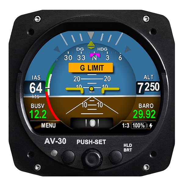
UAvionix Corporation’s aircraft AV-30-C panel display has received STC (Supplemental Type Certification) approval from the U.S. Federal Aviation Administration. The AV-30-C offers pilots an effective and affordable altitude indicator (AI) or directional gyro (DG) replacement with additional features.
AV-30-C is installable as either an AI or DG and adds a suite of in-flight information to the panel out of the box, including GPS navigational data, a probeless angle of attack indicator, baro-corrected altitude, indicated/vertical/true airspeed, non-slaved heading, bus voltage, G load and more with additional features to be announced.
AV-30-C is designed to fit into nearly any aircraft with a three and one-eighth inch round instrument slot without cutting or modifying the panel. By mounting from behind the panel, AV-30-C preserves the aircraft’s original classic look while bringing the latest that modern avionics has to offer to the panel.
The AV-30-C STC provides authorization to install in FAR Part 23 Class 1 and Class 2 aircraft (singles and twins weighing less than 6000 lbs) that are listed on the AV-30-C Approved Model List (AML), containing 635 Aircraft models including Cessna, Piper, Beechcraft, American Champion, Maule, Boeing, Swift, Mooney, Aviat and others. The full AML is available at uAvionix.com/AV-30.
AV-30-C works as a single primary instrument or by installing two units, one as an AI and another as a DG. The aircraft’s original failure-prone vacuum pump system can be removed to further benefit from a fully digital primary instrument cluster.
AV-30-C extends its functionality outside the cockpit as the companion to tailBeaconX, the latest 1090/ES ADS-B transponder with Aireon support for worldwide use and future mandated airspaces. Upon tailBeaconX TSO certification, AV-30-C can double as tailBeaconX’s control interface, allowing the pilot to set the mode and squawk easily, while maintaining AV-30’s existing feature set. tailBeaconX with AV-30-C removes the need to drill additional holes in the airframe to satisfy requirements in countries outside the U.S. and keeps installation costs to a minimum.
“uAvionix is creating avionics with fundamental engineering advantages,” said COO, Ryan Braun. “These are beautiful, no-compromise certified avionics designed to deliver an affordable total cost of ownership. The AV-30-C provides an innovative probeless angle-of-attack and non-slaved directional gyro, both designed to dramatically lower the cost of installation without compromising performance. Where other avionics seem designed to be replaced, the AV-30-C will get better with age. We’re actively developing ADS-B In, electronic flight bag, transponder, and autopilot integrations to ensure AV-30-C becomes an indispensable instrument for every panel.”
AV-30-C will support third-party autopilot systems via the APA-MINI adapter, interfacing AV-30’s heading bug with legacy autopilots. The APA-MINI autopilot adapter is expected to be released in early 2021, with more advanced autopilot integrations to follow.
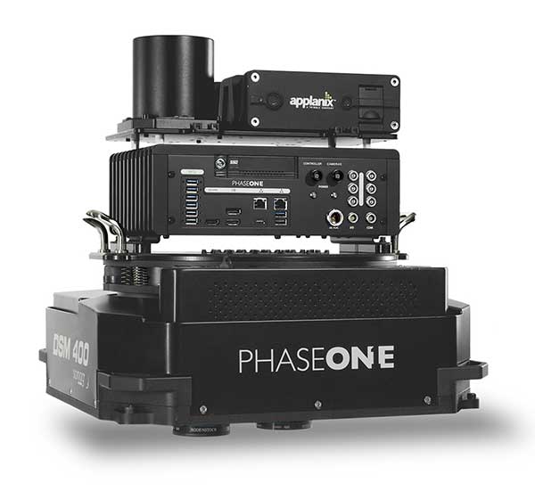
Phase One Industrial has launched a 280-megapixel aerial photogrammetric system, with an image coverage width of more than 20,000 pixels.
The large format enables unprecedented high-quality aerial survey productivity, the company said. Compact and lightweight, the new aerial mapping solution can reduce operating costs and produce better returns on investment than today’s traditional large format systems.
The Phase One Industrial 280MP Aerial Solution consists of an iXM-RS 280F large format camera, Applanix GNSS/IMU receiver (POS AV series), Somag gyro-stabilized mount (DSM 400), Phase One iX Controller and iX Flight Management software.
The system is a large format camera system that easily integrates with the DSM400 gyro-stabilized mount, creating a compact and lightweight system for use in a wide range of aircraft.
At the system’s heart is the iXM-RS 280F, a dual-lens metric camera with 90mm lenses for capturing RGB information, providing precision imaging. Adding a near infrared (NIR) camera generates a 4-band configuration, most useful in agriculture, forestry and pipeline monitoring.
The iXM-RS 280F camera generates a central projection image from two 150MP nadir images with equal ground resolution. The cameras’ backside illuminated CMOS sensor supports very high dynamic range at 83dB. Its high light sensitivity provides superb image quality in challenging low light conditions, enabling operators to take advantage of more flight hours per day and more flight days per year.
“Our 280MP Aerial Solution is a bold and innovative approach to solving customers’ demands for affordable and reliable aerial mapping performance,” said Dov Kalinski, general manager, Phase One Industrial. “Previously, opportunities in the aerial mapping business were restricted due to high cost of equipment and limited aircraft options. While pioneering superior image quality, Phase One Industrial is creating more profitable possibilities in this exciting and important market.”
Aircraft throughout Europe are guided by EUROCONTROL, which will have access to ADS-B data through Aireon. Here, a plane lands at Schiphol Airport in The Netherlands. (Photo: Sjo/iStock Unreleased/Getty Images Plus)
Aireon and EUROCONTROL have signed a 10-year agreement to integrate space-based ADS-B data into their air traffic management processes across EUROCONTROL’S 41 Member States and two Comprehensive Agreement (CA) States.
The space-based automatic dependent surveillance-broadcast (ADS-B) data will enhance aircraft management capabilities, contributing to improve predictability, capacity, environmental impact supporting sustainable growth throughout the European region.
It will also support other applications, such as crisis management, contingency management, environmental monitoring, performance monitoring and expanded datasets for post-analysis, traffic statistics and safety-related assessments.
Spanning 43 countries from Turkey to Ireland, Finland to Portugal, EUROCONTROL’s aircraft management states encompass over 11.5 million square kilometers of terrestrial airspace, as well as part of the airspace over the North Atlantic, Mediterranean and Baltic.
Aireon data will be integrated into the EUROCONTROL’s enhanced tactical flow management system (ETFMS), which provides data to European aviation stakeholders, regardless of operational borders, in real time.
Space-based ADS-B data will enrich ETFMS’s complex traffic demand and slot allocation calculations, which currently rely on ground-based surveillance data and flight plan processing systems. As a result, Aireon’s data will support Europe’s primary flow management system to be more accurate in its trajectory predictions and unlock an otherwise unavailable operational capacity.
“With Aireon’s high-integrity, high-quality data, the EUROCONTROL network manager will have the ability to work with information from beyond the European airspace,” said Eamonn Brennan, director general, EUROCONTROL. “Full integration of Aireon space-based ADS-B data will allow us to be more accurate in our trajectory predictions and ensure higher levels of safety, predictability and efficiency in our flow management operations. This partnership is the latest development in our effort to ensure European airspace is one of the most dynamic and efficient in the world.”
EUROCONTROL. Having been nominated as the Network Manager by the European Commission until the end of 2029, EUROCONTROL is driving a coordinated and technologically advanced approach to the challenges faced by the European air traffic network.
Helping address the improvements that are needed in operations, cybersecurity, service provision, crisis management, airspace design, utilization and more, EUROCONTROL provides support and expertise to air navigation service providers (ANSPs), airlines, airports and military partners in the region to help make European aviation, safe, synchronized, efficient and environmentally friendly.
Aerion. In 2019, the European Aviation Safety Agency (EASA) certified Aireon as the first provider of aircraft surveillance-as-a-service. Additionally, Aireon has the only global, single-source dataset available to the industry.
For EUROCONTROL, this means that once the service is integrated into its systems, it will have unprecedented visibility into the full picture of aircraft arriving, departing and crossing over Europe over an area of six flight hours and 3,000 nautical miles around EUROCONTROL Member States.
“EUROCONTROL is a leader in air traffic flow management. They are the first customer to use Aireon data well beyond their own area of responsibility. This will enable them to maximize the effectiveness of their processes and procedures by including long-range arrivals and neighboring States into their capacity and demand measures,” said Don Thoma, CEO, Aireon. “EUROCONTROL recognizes the global value in connecting ANSPs through a common, high-fidelity, global data source that provides situational awareness of actual aircraft position information. We look forward to the benefits all EUROCONTROL customers will see in the near, medium and long-term.”
Aireon’s data will also be integrated in EUROCONTROL’s new system called iNM, which will implement incremental updates to all of EUROCONTROL’s operational systems and digital infrastructure in the course of this decade.
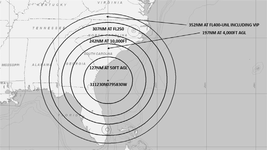
A U.S. Navy exercise in the southeastern United States will involve GPS interference testing that could make aircraft navigation unreliable or unavailable on Aug. 30 and Sept. 5.
The Federal Aviation Administration issued an advisory about the testing, which will be centered in the Atlantic off the coast of Savannah, Georgia, on the SAV VOR 139-degree radial at 84 nautical miles.
It could affect GPS reliability — including WAAS, GBAS and ADS-B — centered at 311230N 0795830W (SAV139084):
within a 352-nautical-mile radius at Flight Level 400
within 307 nautical miles at Flight Level 250
within 242 nautical miles at 10,000 feet
within 197 nautical miles at 4,000 feet above ground level
within a 127-nautical-mile radius at 50 feet above ground level.
The tests are scheduled for 1800 Zulu to 2200 Zulu on Aug. 30, and 1600 Zulu to 2000 Zulu on Sept. 5.
The FAA advisory states that GPS interference notices to airmen may change with little or no notice, and encourages pilots to check regularly for updates. NOTAMs will be published at least 24 hours in advance of any GPS tests.
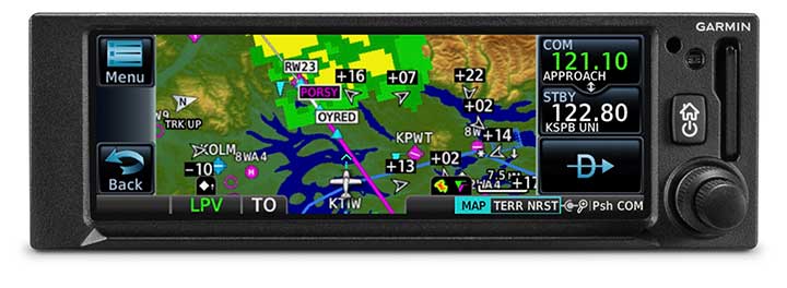
The GNC 355 is a GPS navigator with localizer performance with vertical (LPV) approach guidance and a built-in communications radio. (Photo: Garmin)
Garmin International Inc. has launched the GNC 355 — a GPS navigator with Localizer Performance with Vertical (LPV) approach guidance and built-in communications radio.
With the GNC 355, pilots can take advantage of the benefits of WAAS/SBAS GPS guidance, while also incorporating a modern comm radio into their existing avionics stack.
Intended for Class I/II aircraft that weigh 6,000 lbs./2,721 kg. or less, as well as experimental/amateur-built (EAB) aircraft, the GNC 355 Supplemental Type Certification (STC) is imminent and will be available in August for more than 700 aircraft makes/models.
“Based on the popularity of legacy products like the GX 60 and the GNC 250/300XL, as well as customer excitement for our new GPS 175 and GNX 375, we’re pleased to bring the GNC 355 to market,” said Carl Wolf, Garmin vice president of aviation sales and marketing. “The GNC 355 gives value-minded customers a simple upgrade path to a GPS navigator with a number of capabilities including WAAS/LPV approach guidance, wireless connectivity, a modern Comm radio, and with its standard mark-width form factor, pilots can easily add the GNC 355 without overhauling the panel of their aircraft.”
Aircraft owners can incorporate the GNC 355 into an existing avionics stack because of its standard 6.25-inch wide by 2-inch tall design. A vibrant, colorful and responsive touchscreen display boasts a familiar Garmin user experience, while a dual concentric knob and home button offer added versatility when interfacing with the touchscreen.
The user interface has been optimized for the screen size of the display, while also retaining a familiar menu structure similar to other Garmin products. Pilots can quickly access direct-to functionality, moving map, flight plan, nearest, procedures, waypoint and terrain pages, as well as frequency information using the touchscreen, and create customizable data fields and shortcuts for quick, one-touch access to important information.
Fully WAAS/SBAS IFR-approach-capable, the GNC 355 gives pilots the benefit of flying LPV, as well as Area Navigation (RNAV) approaches. Many approaches offer vertical approach guidance as low as 200-feet above ground level (AGL).
Pilots can also leverage the touchscreen and moving map to generate customized holding patterns over an existing fix in the navigation database or over a user-defined waypoint and easily insert it into a flight plan. Visual approaches are also available within the GNC 355 and provide lateral and vertical approach guidance in visual flight conditions.
Two versions, the GNC 355 and GNC 355A, are available with 25 kHz and 8.33 kHz frequency channel spacing respectively. Using the internal frequency database, airport, weather, Air Route Traffic Control Center (ARTCC) and Flight Service Station (FSS) frequencies are easy to find and can be loaded to the standby position by selecting the frequency from the airport information page. Recent, nearby and saved frequencies also offer easy access to frequency information. For example, with built-in standby frequency monitoring, pilots can listen to ATIS while monitoring tower frequency simultaneously. The airport identifier and frequency type are also displayed below the frequency so pilots can communicate with confidence.
An array of interface options includes the G3X Touch flight display for experimental and certificated aircraft, the G5 electronic flight instrument, the GFC 500 and GFC 600 autopilots, as well as select third-party autopilots. Course deviation and roll steering outputs can also be coupled to the GFC 500/GFC 600 autopilots and select third-party autopilots so procedures such as holds, radius-to-fix (RF) legs and missed approaches may be flown using the autopilot. Aircraft owners can also retain many of their existing flight instruments, audio panels and many legacy CDI/EHSI indicators such as the KI 208/209 products.
Additional interface options include pairing the GNC 355 with a dual-link Garmin Automatic Dependent Surveillance-Broadcast (ADS-B) solution, such as the GTX 345 or GDL 88. When paired with these products, the GNC 355 is capable of displaying subscription-free Flight Information Service-Broadcast (FIS-B) weather and ADS-B traffic targets, which includes patented TargetTrend and TerminalTraffic.
Wireless Connext devices running the Garmin Pilot and FltPlan Go applications. Pilots can also use the Flight Stream 510 to access the wireless benefits of Garmin’s Database Concierge, which uploads aviation database information from the Garmin Pilot app to the GNC 355 in minutes.
The GNC 355 provides a number of additional benefits, including graphical flight plan editing, allowing pilots to more easily edit their flight plan based on an ATC amendment or weather. Features such as FastFind simplify flight plan entry by applying predictive logic to suggest airports and waypoints using current GPS location, while Smart Airspace makes it easier to identify pertinent airspace on the moving map.
The addition of SafeTaxi airport diagrams displays runways, taxiways, Fixed Based Operators (FBOs), hangars and more relative to the aircraft’s location on the airport surface.
The GNC 355 and GNC 355A can be purchased through the Garmin Authorized Dealer network at that time starting at a list price of $6,9951 and $7,6951 respectively.
European Union Aviation Safety Agency (EASA) validation is expected at a later date.
A free GNC 355 trainer app is also available for download on Apple mobile devices, which allows customers to explore the feature set.
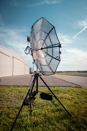
Designed to incorporate aircraft into the MANET, the Auto-Tracking Antenna System is a complete portable ground-to-air system for tracking aircraft, including drones. Army, Navy and foreign customers can use it for better airborne communications relay and full-motion video camera/sensor data transmission, Persistent said.
Photo: Persistent Systems
“The Auto-Tracking Antenna System represents a major step towards achieving the vision of a truly networked battlefield,” said Herb Rubens, CEO of Persistent Systems. “The tracking antenna rotates to follow air assets, keeping them connected to the MANET. “The air platforms orbit over our users on the ground, extending the MANET bubble and keeping soldiers connected to the enterprise. High throughput, low latency connectivity empowers the warfighter and decreases the dependence on SATCOM, which both reduces cost and increases network availability.”
Designed for ease-of-use, quick assembly and portability, the Auto-Tracking Antenna System can be assembled and deployed in less than 15 minutes, the company added.
The portable and lightweight design is completely collapsible, with the main five-foot parabolic dish breaking down into eight individual petals.
The entire system fits into most standard-sized SUVs for easy transport and compact storage.
Photo: Persistent Systems
Mimicking the MPU5’s modular RF structure, the Auto-Tracking Antenna System has interchangeable S-band, L-band and C-band MIMO feeds that allow it to cover all frequencies where Persistent’s five radio modules operate.
The antenna feeds twist-lock into place for quick and simple installation. An Automatic Heading System enables the tracking antenna to self-calibrate prior to operation for greater precision and less than one-degree pointing accuracy.
“Our customers require a system that is simple to put together, turn on, and works,” said Louis Sutherland, vice president of business development at Persistent Systems. “They want to extend the Wave Relay MANET out to aircraft and achieve high data-rates and reliable HD video transmission. The Auto-Tracking Antenna System truly delivers.”
The large parabolic dish enables video streaming out to distances of 130 miles (over 200 kilometers) while maintaining high throughput and strong signal strength.
Photo: Persistent Systems
Combining the precisely aimed tracking system with the MPU5 radio and Wave Relay MANET achieves optimal connectivity and reliable communications for manned and unmanned aircraft to communicate further than ever before.
The antenna is IP67 rated and built to endure harsh environments and weather, so it can be setup and left out for as long as the mission requires.
The Transportation Safety Board of Canada (TSB) is conducting an investigation into the collision between a drone and a passenger aircraft that took place on approach to the Jean Lesage International Airport in Québec City on Oct. 12.
On that day, a Beech King Air A100 operated by Skyjet M. G. was on an instrument flight rules flight from the Rouyn-Noranda (Quebec) airport to the Jean Lesage International Airport in Québec City with two crew members and six passengers on board.
The aircraft was approaching runway 24 and had just passed the final approach fix when the crew noticed an unmanned aerial vehicle (UAV) off the left wing. The aircraft struck the UAV at an altitude of 1500 feet and the crew declared an emergency.
Aircraft rescue and firefighting services were deployed and the aircraft safely landed on runway 24. The aircraft inspection revealed a few scratches and some paint transfer on the top surface of the left wing and scrape marks on the de-icing boot.
The aircraft was then returned to service. No one was injured.