In February I had the privilege of addressing the European Space Agency’s (ESA’s) Navigation Days conference in the Netherlands. An internal ESA event, Navigation Days gathers engineering staff from centers in several countries to discuss the present and future of their endeavors.
Since most of the audience had been “bathing” in Galileo, EGNOS and the evolution of both systems for many years, the Director of Navigation and the Galileo Project Manager thought it would be interesting for all to have an “outsider” perspective and opinions on Galileo and the European GNSS position in the world.
Though my half-hour talk ranged freely, and perhaps somewhat wildly, across many sectors and subjects, it had two main foci: the fundamental differences between Galileo and the three other GNSS, and the future portended by those differences. A future column here will address the latter, that is, the future. At present, the present distinctions.
To me, they distill down to three elements: active stimulus of market development, well-funded research into new applications, and — actually the foundation stone of the afore two — democratically elected governments representing citizenry with altruistic values: a strong desire for the common good, thoughtful regulation, intertwined diversity and open borders.
In sum, Galileo’s strength is the strength of the European Union.
“Active stimulus of market development, well-funded research into new applications, and citizenry with altruistic values.”
For example, the Horizon 2020 framework program offers €80 billion to support and foster research from 2014–2020. Three E-GNSS calls in H2020 have a total budget of €100.9 million and they synergize with topics on societal challenges. To my knowledge, the U.S. has nothing like this in terms of downstream R&D programs; it is left to the marketplace to initiate and sustain such efforts.This corresponds to the respective economic systems of the two political entities. West of the Atlantic has historically taken a laissez-faire attitude towards applications, development and societal challenges: let the marketplace act.
The other two GNSS powers, Russia and China, as authoritarian regimes, may build viable GNSS and mandate their use, but the synergy between government and users is lacking. This missing link could prove an economic as well as technical weakness in the future. In some respects, it already has.
Particularly in transportation, freight and liability-critical applications, where the European GNSS have devoted extensive forethought to both user and societal needs (read “the environment”), we may see a distinctly different and more progressive future unfolding in Western Europe, led by Galileo.
On the other hand, in the realm of pure consumer devices, the market may be a stronger driver, and U.S. products and services with a GPS bent may remain dominant.
The Public Regulated Service (PRS) for defense, security, emergencies and critical infrastructure, is the hidden strength of Galileo.
I’ve run out of space here for non-scientific speculations, but will expand them in a future column or online.
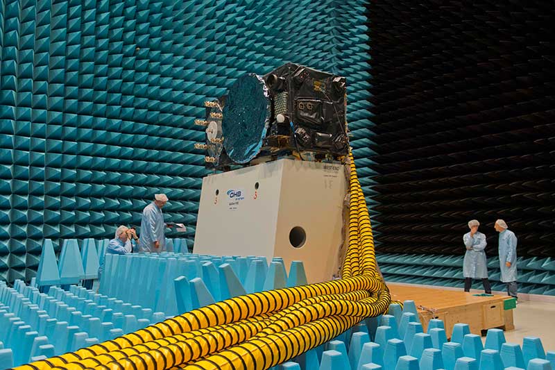
Inside the ESTEC Test Center, Galileo’s First Operational Capability first flight model, FM1, prepares for passive intermodulation testing in the Maxwell electromagnetic facility. (Photo: ESA-Anneke Le Floc’h)
Gazing through soaring plexiglass walls at the space simulation room of the European Space Agency’s Test Center in the Netherlands affords a glimpse into scientific history.
I felt a frisson, a highly regimented frisson if you will, of vicarious thrill for the rigors, rhythms and methods of research and testing as I toured the center after giving a keynote at the agency’s Navigation Days. Here, the final birthing touches were administered to transmitters beaming forth the Second Golden Age of satellite-based navigation.
One can debate which constellation combination will prove most fruitful to users: GPS plus GLONASS, GPS plus BeiDou, GPS plus Galileo (note the common term). I believe it will be the last, because of the close synergy and symbiosis of the two commercial arenas, North America and Europe.
All Galileo Full Operational Capability (FOC) satellites had their mettle and metals probed, radiated, bombarded, shaken and shocked here before they journeyed to space. The test center’s role is to verify, intensively and for months per satellite, that it can perform well for the whole of its planned lifetime.
A mass property test checks that the center of gravity and mass are aligned within design specifications, so that the satellite’s orientation can be accurately and economically controlled with thruster firings in orbit, prolonging work life by conserving propellant.
A five-week thermal-vacuum test runs inside a 4.5-meter diameter stainless steel vacuum chamber, the Phenix. An inner thermal tent heats to simulate solar radiation and cools with liquid nitrogen to create the chill of sunless space.
In the Maxwell test chamber, spiky radio-absorbent anechoic walls test electromagnetic compatibility to ensure that all systems operate together without interference. Noise horns generate more than 140 decibels to simulate a violent launch. A quad shaker table vibrates the satellite up, sideways and down, as accelerometers search for hazardous internal vibration, gathering data across hundreds of channels.
Altogether a severe trial, a crucible from which the FOC satellites emerge certified and ready for space.
Oh, that we humans were similarly tested before placement in positions of power.
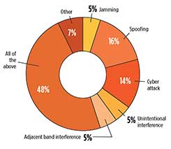
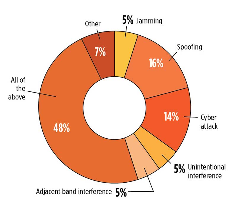
What is the greatest threat to GNSS over the next three years? Click to enlarge. (Source: GPS World 2018 State of the GNSS Industry report)
When we designed the survey of the global PNT community for the 2018 State of the GNSS Industry report, we put a couple of new wrinkles into the online questionnaire. We wanted to know, succinctly, what you felt was the number one obstacle to growth for your organization. And, with the same brevity, what you saw as the number one opportunity for growth.
The answers most frequently given within each sector — mobile, OEM, survey, UAV, transportation, machine control, mapping and defense & government — appear on those respective pages in this issue. They weren’t the only answers, by far.
Obstacles to Growth
Other stumbling blocks that were called out included security, competitors (sometimes mentioned by name), politics (sometimes mentioned by party), budgets, funding, understanding, ignorance, management, bureaucracy, age, and that enduring favorite, time.
The most frequently cited obstacles to growth were:
regulation, and
the lack of qualified staff, personnel, engineers.
One ingenious survey-taker somehow found a way to cram 21 words into an answer box meant for only one or two. “In my industry, deep technical talent that addresses the specific issues. Without that, the ‘big picture’ judgments are often just wrong.”
This problem is not new, nor is it particular to the GNSS/PNT industry. The fact that it is with us year after year suggests that it is not getting enough effective attention. Talented engineers can be imported, yes, if the homegrown supply falls short. In the current political climate, this may not be a strategy with legs. Even given a totally benign immigration regulatory landscape, it is far from a panacea. More on this in a moment.
Growth Opportunities
Various flavors of technology integration, both multi-GNSS and non-GNSS, led the pack in nearly every sector. Other popular answers included customization, broadband, autonomous navigation, Galileo, international markets, alt-nav, Brexit, the Cloud, M-code, anti-jamming, connectivity, flexibility, more clients, and, in riposte to the aforementioned obstacle: training, education, or simply engineering.
The great American thinker Margaret Mead said, “We are continually faced with great opportunities which are brilliantly disguised as unsolvable problems.”
If your organization encounters this perennial problem, this shortage of qualified staff that stifles innovation, inhibits growth, and causes you to pass on new ventures that are just out of reach, here’s the biggest whopping opportunity of all: get involved with higher education and engineering graduate schools in your area.
The talent is there. If you’re not out actively cultivating, encouraging, training and recruiting it, those bright young engineering people will be drawn instead to Internet ventures or gaming software or other industries that sap the soul but nourish the pocket — and those are your true competitors.
Using lasers in conjunction with GPS can collect richer data, faster, and streamline survey and mapping projects across many disciplines that draw on mapping and geospatial information systems.
To learn more about the exact processes involved in Integrating a professional measurement and mapping laser to your GIS toolbox, both saving time and enabling collection of additional attribute data attend GPS World’s free webinar on Thursday, Aug. 16: LaserGIS: Your Gateway to Collect More GIS Data in Less Time.
The webinar will be available for download 24 hours after broadcast time, for those unable to attend live.
The applicable fields for this enabling technology include surveying, construction, ecosystem management, watershed analysis, geological mapping, environmental impact assessments and more.
Photo: Laser Technology Inc.
A natural resources ecosystem manager said, “I map areas that are either impossible to occupy or simply can’t be disturbed, so using laser-based reflectorless measurement technology is ideal for wildlife habitat research. When performing soil surveys, I can easily calculate the grade of a slope by using the missing line routine. I even used the Laser Technology TruPulse once to track the progress of a wildfire. This technology is a must-have for our crews because it’s highly portable and produces reliable data.”
A land conservation specialist performing watershed analysis added, “Stream channel surveying tools have come a long way since I graduated college. I’m now able to mark a stream’s course, calculate the gradient and measure the width of the riparian zone, all with a simple point-and-shoot TruPulse laser. For wetland delineation projects, being able to shoot directly to the bank saves a huge amount of time and keeps me and my crew as dry as possible.”
A geologist performing mapping as part of his work routine said, “I need to accurately track geological structures in mines and outcrops, and would really struggle with collecting measurements if it wasn’t for my TruPulse 360. With the laser, I can get a measurement to any type of surface and don’t have to stand in dangerous areas, so I can be extremely productive and safe. When I have to verify the volume of our biomass stockpile, I just integrate my laser with MapSmart and get reliable calculations in minutes, right in the field.”
Finally, an archaeologist performing an environmental impact assessment stated, “Conserving archaeology sites is just as important as researching and analyzing them. Integrating the TruPulse with GPS allows me to make better planning decisions with all types of resource considerations without compromising data integrity or delicate areas. The TruPulse’s onboard solutions for height and 3D missing line make my job so much easier and far more productive than conventional measurement tools.”
Alan Cameron Editor-in-Chief and Publisher, GPS World
“All the News that Fits” can sometimes be a hard motto to live up to, and it has turned out so this month. I want to get more material into our pages for your perusal, and it just could not be crammed into the System of System pages in this issue. Therefore, I cede my “Out in Front” editorial to the 27 gentlepeople, executives across the commercial, scientific and government agency spectrum, who wrote to U.S. Federal Communications Commission (FCC) chair Ajit Pai on July 18.
The core quotes from the letter appear here. However, there’s more meat on the bones and I want to present it here.
“The undersigned organizations, representing entities that provide and rely upon critical GPS, satellite communications (“SATCOM”) services, and essential weather and other environmental data, write to inform you that the threat of harmful interference from Ligado’s proposed ancillary terrestrial component (“ATC”) service continues to pose a significant risk of harmful interference despite Ligado’s May 31, 2018, amendments to its license modification applications in the above-referenced file numbers. The record, augmented by recent government reports, makes clear that the interference will be particularly impactful to the countless government and commercial entities that rely on GPS and SATCOM services for aviation safety and other critical services and the many groups that receive and depend upon real-time weather and related environmental information from National Oceanic and Atmospheric Administration (“NOAA”) satellites…
“We recognize the importance of ensuring that there is sufficient spectrum for mobile broadband, and the Commission has recently taken many steps to address that challenge. However, at a time in which the Administration has placed so much emphasis on the critical importance of space-based communications — through the revival of the National Space Council and other policy initiatives — the FCC should not undermine the nation’s critical space leadership.2 Granting Ligado’s request would harm the nation’s satellite industry and the broad sectors of the country that benefit from American space leadership every day in at least three ways. First, it would threaten the reliability of critical position, navigation and timing (“PNT”) services, including GPS and also an emerging satellite time and location (“STL”) capability augmenting GPS.
“Second, it would undermine the investment-backed expectations of those who operate commercial satellite systems by fundamentally altering the interference environment decades after licensing.
“And third, it would convert 40 MHz of increasingly rare satellite spectrum away from satellite use, rewarding a company for underutilizing its satellite spectrum rather than investing in new satellite technologies.”
In addition to several organizations, the letter is signed by the Aircraft Owners and Pilots Association, the American Geophysical Union, American Weather and Climate Industry Association and the National Emergency Number Association.
I’m impressed, as always, by the engagement of our webinar audience. Questions are pouring in about the speakers’ presentations, in addition to knowledgable queries submitted before the webinar began. These events strike me as, hour for hour, the best professional education one can get, short of leaving the office for a week to attend ION GNSS+ or the institute’s other conferences through the year, or the European Navigation Conference or Intergeo or others of the like. And a webinar takes only an hour of your time! From the comfort of your desk! Or sofa, even.
Here are some of the questions posed, and brief digests of our experts’ answers. The panel included John Fischer, VP Advanced R&D at Orolia, assisted by Jon Sinden, product manager for Rugged PNT; Tim Erbes, CTO at Talen-X; and Carol Politi, CEO at TRX Systems.
Q: Role of Galileo Public Regulated Service (PRS) in GPS-disrupted environment? Particularly given NATO alliance and cooperation? Any more detail about use of other GNSS to make solution more robust?
A: The PRS is certainly low-hanging fruit for traditional partners to take advantage of both GPS and Galileo, and I imagine fielded solutions will soon start to show that. There are substantial benefits to be gained from use of other GNSS as well.
Q: Please discuss the hardened military aspects of coming GPS III signals and codes. How will the new GPS III constellation impact your products?
A: Block III alone is not enough to make this happen. A new M-code will eventually replace the SAASM M-code, and it will provide a true separation from the civilian signal, different from the current situation with M-code and C/A code. Already, a dozen or more IIF satellites are now transmitting it. But the upgrade has to happen in three places for it to become effective: the satellites, the user receiver — and this is a complex, extremely broad and varied picture in the military realm — and finally the ground control system. There have been some difficulties in deploying the new OCX. This is the biggest determining factor of when these new features will roll out.
Q: What is the potential role of other means of PNT: eLoran, Iridium STL, lidar, and so on?
A: ELoran a very good alternative, ideal from the point of view of diversity: terrestrial instead of satellite, high-power instead of low, other end of spectrum from GNSS. Orolia published a white paper on a holistic approach towards resilient PNT, discussing eLoran and STL; see our website.
There are additional opportunities for outside-the-box solutions, for example, the sensors aboard tanks for anti-missile defense systems. They could also be used for PNT. Networked data radios for crowdsourced PNT data.
A U.S. soldier preparing his Blue Force Tracker before departing Camp Victory, Iraq in 2005. (Photo: Petty Officer 1st Class Brien Aho, U.S. Navy)
A free GPS World webinar, sponsored by Orolia and taking place at 1 p.m. EDT on Thursday, June 21, will discuss “Defense PNT in Challenged Environments.”
The webinar will consider the reliance on GPS in modern land-warfare systems, as well as the potential effects of GPS disruption on their operations and ways to protect their ability to continue operating in a GPS-disrupted environment.
John Fischer, vice president of advanced R&D at Orolia; John Sinden, product manager for rugged PNT at Orolia; and Tim Erbes, CTO at Talen-X, will present during the webinar. GPS World Editor-in-Chief Alan Cameron will moderate it.
Fischer, who has worked with global navigation satellite systems, wireless, positioning navigation and timing at Orolia for more than 15 years, will highlight protecting GPS-reliant military systems during his presentation. Fischer will also discuss considerations for protecting land-warfare systems’ ability to continue operating in a GPS-disrupted environment from jamming, spoofing or environmental interference.
“If successful,” the story elaborated, “the project will divide the entire world into two zones of influence by two united systems: GLONASS-BeiDou and GPS-Galileo, operated by the U.S. and the European Union.”
Intriguing. Mind-boggling. With some initial smattering of verisimilitude.
I don’t want to say, “Yet in the end, spurious.” Because we haven’t yet reached the end. But indicators point in that direction.
What. The story claimed that “The countries will reportedly negotiate the merger in May at the International Conference on Advanced Technologies in Manufacturing and Materials Engineering in the Chinese city of Harbin, Izvestia daily reports.”
The primary reason for all GNSS and for GPS itself in the very beginning is military advantage. For these two superpowers in particular to share one military resource is unthinkable; for either to disclose aspects of its security and weapons guidance operations to the other, untenable.
Whence. Who is RT? According to Wikipedia, the outfit formerly known as Russia Today is an international television network funded by the Russian government, operating cable and satellite television channels and internet content directed to audiences outside of Russia. Based in Moscow, it presents around-the-clock news providing “a Russian viewpoint on major global events.” In 2008, Prime Minister Vladimir Putin included RT’s parent organization on a list of core organizations of strategic importance to Russia.
RT has been frequently described as a propaganda outlet for the Russian government and its foreign policy, and has been accused of spreading disinformation, broadcasting “materially misleading” content. In 2017, during the French presidential election, a spokesperson for successful candidate Emmanuel Macron said that both RT and the Sputnik news agency showed a “systematic desire to issue fake news and false information,” and banned them from campaign events.
Why. No one to whom I reached out in either Russian or Chinese government or satnav operations agency has returned any comment. Silence on all fronts.
We can only guess at the underlying reasons for this floated, unsubstantiated story. To stir things up, as has been done in other arenas by these same “news” actors. It’s just a bit stinging, and a bit scary, to find it in our own world of science and technology.
There is no evidence that any GLONASS officials have been in any way involved — there’s no evidence of anything at all, when you come right down to it. The development does not reflect favorably on the Russian news system, and it may be as well to take everything from Moscow with a barrel of salt until something more tangible emerges.
A GLONASS-M satellite is prepped for launched in February 2016. (Photo: Russian Ministry of Defense)
Views from the top drive this issue of the magazine: personal essays from the directing officers and/or architects of each global satnav system.
The plots of the four articles are the same: what innovations were accomplished in 2017, and what new features to look for in 2018. But the themes differ. If you reflect at the end of each article, try to read between the lines, divine what message seems most important to the author — then distinctions surface.
I’m not suggesting that the directors of each satnav system are trying to accomplish different things. All share the goal of providing the highest quality product and service. I posit that the hands above these guiding hands, atop the top — that is, the national governments paying for each system and directing the directors — do indeed have different priorities. These priorities may produce differing results for industry, markets and users.
The column in November’s GNSS Design & Test e-newsletter elaborates on this hypothesis, as there’s not sufficient space here. Hyper-briefly: the most marked contrast appears between the United States on the one hand and Europe and China on the other. The former appears focused on maintaining the Gold Standard of signals, on beefing up security, and then pretty much letting the market take care of innovation once the space signal hits the Earth’s surface. The other two project clear messages of working closely with industry sectors to encourage and intensify use. For them, GNSS is an economic tool, not merely a political one.
As for my 2018, I will attend both events below, and hope to talk with as many readers as possible there.
Cognizant Autonomous Systems for Safety-Critical Applications Workshop
January 29, 2018 Reston, Virginia
Join a full day of expert presentations and discussions on the opportunities and challenges (technical, commercial, ethical and legal) associated with developing fully autonomous systems that are cognizant and trustworthy for safety-critical applications. Free; sponsored by the Institute of Navigation. Speakers from the National Science Foundation, Department of Transportation, Air Force Research Laboratory, Top Flight Technologies, University of California-Santa Barbara, Santa Clara University, The Ohio State University and more. View more details here.
Munich Satellite Navigation Summit: GNSS — The key to autonomy?
March 5–7, 2018 Munich, Germany
This three-day international conference focuses on the latest developments in satellite-based navigation, gathering high-ranking speakers from industry, science and governments for a broad overview and differing perspectives. Topics include status and real-world results of Galileo; modernization of GPS, GLONASS and BeiDou; developments of QZSS and NavIC; the need for GNSS authentication; civil use of Galileo Public Regulated Service; legal aspects of GNSS; and autonomy within a single GNSS — still possible? Get more details here.
We just went to press with the December issue of GPS World magazine, its cover story consisting of personal essays from the directing officers and architects of each global satnav system.
You’ll have to wait for your copy to arrive in the mail or the digital edition to land in your inbox to read those articles in full, but I’ll give you a sneak preview here — just enough to springboard my hypothesis that, yes, system operators build great systems, but they are still subject to the whims of their national governments.
And those governments are operating on increasingly divergent agendas that will bring consequences upon the respective GNSS industries.
The plots of the four articles by the effective CEOs of each GNSS are the same: what innovations were accomplished in 2017, and what new features to look for in 2018. But the themes differ. If you reflect at the end of each article, try to read between the lines, divine what message seems most important to the author — then distinctions surface.
In our December pages we hear from:
Col. Steve Whitney
Col. Steven Whitney, Director, Global Positioning Systems Directorate:
“The Air Force is already exploring new, emerging technologies and capabilities to even further advance the robustness of the GPS enterprise, with the vision that GPS will always remain the Gold Standard for the worldwide PNT community.”
Sergey Karutin, GLONASS designer general; Nicolay Testoedov, Director General, SC Information Satellite Systems; and Andrey Tulin, Director General, SC Russian Space Systems:
“The traditional GLONASS conception of signal-in-space accuracy is now being augmented by the user level performance estimation. Due to the fact that the signal propagation environment contributes a lot to the positioning error budget, it is obvious that users need information that would reduce the influence of signal propagation path on the positioning accuracy.”
From left: Sergey Karutin, Nicolay Testoedov and Andrey TulinPaul Verhoef
Paul Verhoef, Director of the Galileo Programme and Navigation-related Activities, European Space Agency:
“The world of mobile-device LBS is going to change in 2018, and it will be due to the availability of Galileo. It will not be the first time the partnership of ESA, the European Commission (EC) and the GSA has made a service available that has changed the nature of the marketplace. “
Changfeng Yang, Chief Architect of BeiDou Navigation Satellite System:
“BDS-related products have gained access to the markets of more than 70 countries and regions, more than 30 of which are along the (land-based) Belt and (maritime) Road (in line with the Belt and Road Initiative). Through joint applications with other compatible navigation satellite systems, BDS provides global users with diversified choices for better application experience.”
Changfeng Yang
I’m not suggesting that the directors of each satnav system are trying to accomplish different things. All share the goal of providing the highest quality product and service. I posit that the hands above these guiding hands, atop the top — that is, the national governments paying for each system and directing the directors — do indeed have different priorities. Accuracy is not all that matters on the international scene, taken as a whole. Sound economies, vigorous markets, vibrant technologies, tradeable-upon intellectual property and highly trained corps of engineers all count for as much.
The respective governments’ priorities, which encompass much more than GNSS but surely have an effect upon it, may produce differing results for industry, markets and users. In that light I would bring to your attention a November 14 op-ed column by Thomas Friedman in the New York Times. I’ll return to this in a moment.
The most marked contrast in the “theme” or GNSS subtext of our December essays appears between the United States on the one hand and Europe and China on the other.
GPS appears focused on maintaining the Gold Standard of signals and on beefing up security, particularly for the military. Innovations such as the L2C signal, drawn up with significant if not predominant civil-sector input, will bring important growth and expansion of capabilities. But aside from that, it appears that industry can be left to itself to take care of innovation once the space signal hits the Earth’s surface.
GLONASS communicates a desire to burnish its reputation for accuracy and relevance. Once pre-eminently second among GNSS, it need to bootstrap itself back into competition to secure its increasingly tenuous toeholds in foreign markets.
Galileo and BeiDou project clear messages of working closely with industry sectors to encourage and intensify use. For the governments of Europe and China, GNSS is an economic tool, not merely a political one.
Now for Friedman’s thoughts on the international scene, quickly excerpted in their most relevant glimpses on the GNSS landscape:
“We’re going through a change in the “climate” of globalization: from an interconnected world to an interdependent one; from a world of walls, where you build your wealth by hoarding resources, to a world of webs, where you thrive by connecting your citizens to the most flows of ideas, trade, innovation and education.”
[….]
“In response to a more interdependent world, China is deepening its trade ties to all the fast-growing Asian markets around it through its “One Belt, One Road” project.”
[….]
“China has embarked on a plan called “Made in China 2025” that’s plowing government funds and research into commercializing 10 strategic industries while creating regulations and swiping intellectual property from abroad to make them all grow faster. These industries include electric vehicles, new materials, artificial intelligence, integrated circuits, biopharmacy, quantum computing, 5G mobile communications, and robotics.”
The European Union is actively and aggressively pursuing many projects and mandates similar to those underway in China.
The U.S., not so much. Not even near. In an environment in which it currently imports engineers to fill yawning vacancies in its high-tech work force, how long before it is reduced to importing technology as well, and at what cost?
Hope to See You There. In early of 2018, I will attend both events below, and look forward to talking with as many readers as possible at each event.
Join a full day of expert presentations and discussions on the opportunities and challenges (technical, commercial, ethical and legal) associated with developing fully autonomous systems that are cognizant and trustworthy for safety-critical applications. Free; sponsored by the Institute of Navigation. Speakers from the National Science Foundation, Department of Transportation, Air Force Research Laboratory, Top Flight Technologies, University of California-Santa Barbara, Santa Clara University, The Ohio State University and more.
This three-day international conference focuses on the latest developments in satellite-based navigation, gathering high-ranking speakers from industry, science and governments for a broad overview and differing perspectives. Topics include status and real-world results of Galileo; modernization of GPS, GLONASS and BeiDou; developments of QZSS and NavIC; the need for GNSS authentication; civil use of Galileo Public Regulated Service; legal aspects of GNSS; and autonomy within a single GNSS — still possible?
Ligado Networks will appear and present at the National Space-Based Positioning, Navigation and Timing Advisory Board’s (PNTAB) meeting on Nov. 15 in Southern California.
Ligado and its predecessors have sought to install high-powered ground transmitters that have been shown to harm and overwhelm GPS signals and receivers in their general vicinity. The controversy has simmered for at least eight years without resolution.
That final resolution will ultimately be taken by the Federal Communications Commission (FCC), although congressional participation is also conceivable, since national infrastructure security is involved.
Meeting Locale. The PNTAB meeting will take place Wednesday, November 15, 2017, 9:00 a.m. to 5:00 p.m.; and Thursday, Nov. 16, 9 a.m. to 1 p.m., at the Crowne Plaza Redondo Beach & Marina Hotel, 300 North Harbor Drive, Redondo Beach, California, approximately a half hour’s drive south of Los Angeles International Airport. The meeting will be open to the public up to the seating capacity of the room. Visitors will be requested to sign a visitor’s register.
From June 28, 2017, PNTAB presentation by Brad Parkinson.
The central issue in this long-running fight is the as-yet unknown — though uniformly predicted by the various rounds of testing over the last eight years — effects of Ligado signals on a huge installed industrial and governmental base of GPS receivers, some of which are essential to the nation’s critical infrastructure.
Ligado Networks, the current-day incarnation of once-bankrupt LightSquared, seeks FCC permission to apply the satellite-based frequency licenses it owns to be broadcast from a ground-based network. This would put a powerful nearby signal immediately adjacent to the much weaker, more distantly emanating GPS signals, and by the way, those from other GNSS as well. Tests in 2011 and further testing in 2016 demonstrated these powerful signals interfering with GPS receivers.
Brad Parkinson
The Ligado appearance comes in response to an open letter, posted on Oct. 10 by PNTAB First Vice-Chair Brad Parkinson, inviting Ligado CEO Doug Smith to speak to the Advisory Board. That invitation itself emerged after a season of what have been termed “attack” statements issued in various forums by Ligado, which were in turn stimulated by two early-summer letters:
1. A June 27 letter from the American Geophysical Union, Aerospace Industries Association, American Meteorological Society, Aircraft Owners and Pilot s Association, Airlines for America, General Aviation Manufacturers Association, International Air Transport Association, Iridium Communications, Thales USA and other organizations (totaling 22) to the FCC opposing Ligado’s request.
“The undersigned organizations . . . write to reiterate that the threat of harmful interference from Ligado’s proposed ancillary terrestrial component (“ATC”) service remain real and persistent. Contra ry to the assertions in Ligado’s FCC advocacy and recent media blitz, its proposed terrestrial operations continue to pose a significant interference risk to numerous parties . . . . The risks to these critical services are very real and, consistent with the public interest, cannot be brushed aside.
That letter further notes that “Ligado seeks the ability to sell its spectrum to the highest bidder, underscoring the uncertainty of any prospective value of the services it has on previous occasions suggested it may provide. There is a clear effort by Ligado to downplay the significance of the technical concerns it continues to receive from numerous directions.”
2. A July 5 letter from the PNT Advisory Board to Deputy Secretary of Defense Robert O. Work and Deputy Secretary of Transportation Jeffrey A. Rosen, the co-chairs of the National Executive Committee for Space‐based Positioning, strongly opposing the Ligado proposal.
From June 28, 2017, PNTAB presentation by Brad Parkinson.
“The revised [Ligado] proposal to the FCC is fundamentally unchanged from a previous proposal reviewed in 2011. Extensive government testing in 2011 and in 2016, clearly shows that both proposals cause definitive harmful interference to many classes of GPS receivers.”
“All GPS stakeholders should be wary of any incremental approaches to deploying mobile broadband services in the mobile satellite systems (MSS) band. For example, initial services could operate at reduced power levels on a temporary basis to protect only a subset of GPS users, before moving to full — power levels that will cause widespread interference to many other classes of GPS users. Regulatory decisions must be based on the ultimate end-state of any systems proposed for operation in the bands adjacent to GPS, and must protect all classes of GPS users. Unfortunately, the latest industry proposal does not acknowledge the legitimacy of, and the need to protect, dozens of precise applications of great national importance.”
From June 28, 2017, PNTAB presentation by Brad Parkinson.
Round Two. The struggle has been a prolonged one, with many twists and turns, however coalescing into two main periods of activity:
2011-12, when the first round of tests showed then-LightSquared’s proposed network would overload the vast majority of GPS receivers. The Federal Communications Commission (FCC) tabled the proposal, and the company, holding spectrum licenses whose value could range far into the billions of dollars, filed for bankruptcy.
2016–18. LightSquared emerged from Chapter 11 in 2015 as Ligado Networks, positing a modified network plan, but one whose organizing concept remains unchanged, causing deep and continued alarm over GPS interference. 2017 tests, conducted by a firm and a government organization hired by Ligado, essentially reconfirmed the 2011 results. The tests found that the proposed ground towers would significantly interfere with GPS receivers as far away as 4 to 5 kilometers, “killing them dead” in the words of one expert who reviewed the test data.
Parkinson’s October 10 letter invites Ligado CEO Doug Scott “to provide the committee with clear up-to-date design information. . . . How might the system as now envisioned be deployed? How many ground terminals are needed, for example, and where would they be?”
Previous LightSquared and Ligado presentations have been long on promise but short on details. In fact, sound technical underpinning has not been communicated.
From June 28, 2017, PNTAB presentation by Brad Parkinson.
Parkinson writes “we would therefore encourage you to specifically describe your implementation plan , with a corresponding test plan address ing the issues we have openly raised . We request you specifically focus on those regarding the potential for interfering with any GPS /GNSS services that operate in the protected Space – to – Earth L band (1559 – 1610 MHz) . Included should be all modes of operation and the use of all current and future GNSS sign als. Without these specific technical details and corresponding evaluations, we can only conjecture as to what you are really proposing .”
Later, he affirms “our focus is to provide advice based on deep engineering and related expertise . As you know, interference to GPS/GNSS can adversely affect numerous safety – of – life systems , other vital national assets, and applications comprising over $60 billion of annual U.S. productivity benefits .”
Parkinson and the PNTAB have had better luck securing a Ligado appearance than did GPS World magazine. In August of this year, Ligado’s senior vice president and chief engineer for radio access technologies thrice declined an invitation to give a brief Expert Opinion for the September issue on the question: How can the safety, security, and full utility of GNSS applications be ensured while evolving best, most efficient use of limited, very valuable electromagnetic spectrum?
Just a Refresher. The PNTAB meeting will be held Wednesday, November 15, 2017, 9:00 a.m. to 5:00 p.m.; and Thursday, November 16, 2017, 9:00 a.m. to 1:00 p.m., at the Crowne Plaza Redondo Beach & Marina Hotel, 300 North Harbor Drive, Redondo Beach, CA, approximately a half hour’s drive south of Los Angeles International Airport. The meeting will be open to the public up to the seating capacity of the room. Visitors will be requested to sign a visitor’s register.
Ligado is by no means the only item on the Committee’s docket, but is very likely to be the pièce de résistance. The full agenda for the meeting includes:
Update on U.S. Space-Based Positioning, Navigation and Timing (PNT) Policy and Global Positioning System (GPS) modernization.
Prioritize current and planned GPS capabilities and services while assessing future PNT architecture alternatives with a focus on affordability.
Examine methods in which to Protect, Toughen, and Augment (PTA) access to GPS/Global Navigation Satellite Systems (GNSS) services in key domains for multiple user sectors.
Assess economic impacts of GPS/GNSS on the United States and in select international regions, with a consideration towards effects of potential PNT service disruptions if radio spectrum interference is introduced.
Review the potential benefits, perceived vulnerabilities, and any proposed regulatory constraints to accessing foreign Radio Navigation Satellite Service (RNSS) signals in the United States and subsequent impacts on multi-GNSS receiver markets.
Explore opportunities for enhancing the interoperability of GPS with other emerging international GNSS.
Examine emerging trends and requirements for PNT services in U.S. and international fora through PNT Board technical assessments, including back-up services for terrestrial, maritime, aviation, and space users.
In Portland, Oregon, and in Berlin, Germany, the two largest and most important international conferences on GPS, GNSS, PNT, survey, mapping and geodesy take place this year on exactly the same dates — just 5,177 miles apart. Now that’s bad timing. Our strategy is to divide our forces and send key personnel to interact with industry leaders at each gathering — to bring you the news and developing stories you need to keep on the forefront of change.
If you’re at ION GNSS+ or Intergeo, look for these faces, come up and introduce yourselves. We want to talk with you! If you’re not fortunate enough to attend either conference, look to our website, newsletters and this magazine for product launches, videos and in-depth stories filed from the developing frontiers of PNT. We’ll be reporting !!Live!! and for weeks, even months, to come.
Attending Intergeo in Berlin:
Burch
Barwacz
Joyce
Gerard
Tim Burch is our survey editor; in his day job he’s a professional surveyor and board of directors secretary of that profession’s national society.
Allison Barwacz is digital media content producer for North Coast Media (NCM, that’s us) with a passion for videography and writing.
Mike Joyce and Ryan Gerard, senior account manager and account manager, respectively, work closely with our marketing partners, who make this magazine and multi-media communications channel possible.
Attending ION GNSS+ in Portland:
Stoltman
Whitford
Mitchell
Cozzens
Harms
Sabau
Limpert
Cameron
Langley
Kevin Stoltman is founder and president of NCM, with a distinguished career in business-to-business publishing.
Marty Whitford is editorial director and publisher; earlier, he actually worked at GPS World and attended ION-GNSS 2004.
Michelle Mitchell is account manager for GPS World and senior marketing and event manager for NCM. She knows the GPS industry landscape and players extremely well.
Tracy Cozzens is our managing editor, with her hands on all the controls.
Joelle Harms is an award-winning digital media manager, focused on content planning and creation.
Joe Sabau is an account manager with a keen eye for market trends.
Kelly Limpert is a digital media content producer developing a strong online and social media presence for all of our partners.
Richard Langley is GPS World’s innovation editor and a professor at the University of New Brunswick.