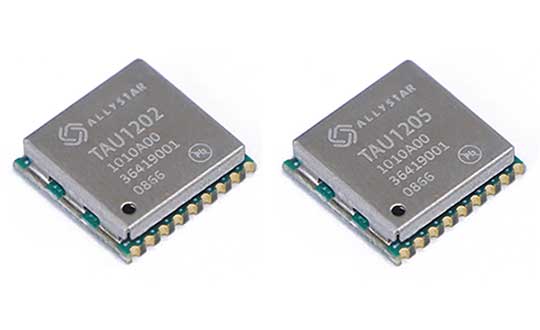
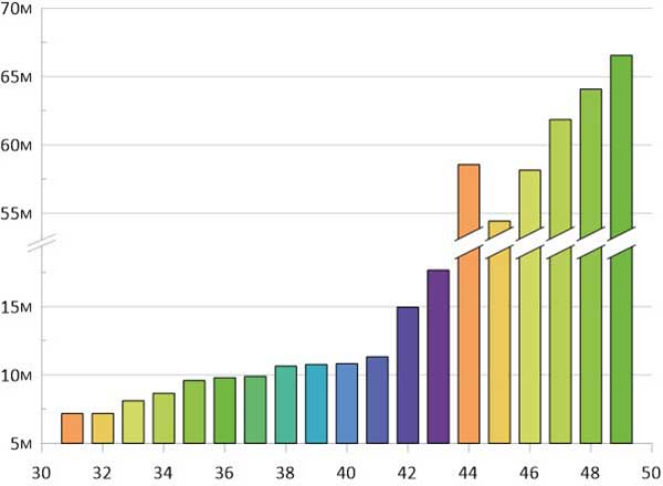
Allystar Technology Co. Ltd. has launched the dual-band multi-GNSS modules TAU1202/TAU1205, which support both the L1 and L5 bands to enhance sub-meter positioning accuracy. Constellations received include GPS, Galileo, GLONASS, BeiDou, QZSS and IRNSS.
Besides the L1 band, TAU1202 and TAU1205 also support L5/B2a/E5a, which are expected to have lower noise and significantly reduced multipath mitigation because of the higher chipping rate of L5 signals relative to L1 C/A code.
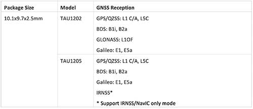
Chart: Allystar
TAU1205 supports IRNSS (NavIC) which makes it suitable for navigation in the urban areas of India and the Middle East, as there are seven NavIC satellites with a higher elevation than both GPS and Galileo satellites.
Photo: Allystar
Powered by Allystar Cynosure III GNSS chipset and with built-in low-noise amplifier and surface acoustic wave (SAW) filter, TAU1202 and TAU1205 provide higher sensitivity, ensuring exceptional acquisition and tracking performance even in weak signal areas.
Based on 40-nm manufacturing processes of the Cynosure III GNSS chipset and state-of-the art internal PMU, TAU1202/TAU1205 comes with very low power consumption at less than 40 mA.
Multiple communication interfaces including UART and I2C simplify customer designs and provide a better time-to-market for customers’ products.
“Due to its excellent performance in urban area, compact design and concurrent multi-GNSS reception, TAU1202/TAU1205 has become a popular selection for vehicle and asset tracking in worldwide,” said Zhang Yanping, Allystar product line manager. “The launch of TAU1202/TAU1205 shows Allystar continues to drive GNSS evolution in thte navigation mass market.”
Allystar started TAU1202/TAU1205 mass production in the second half of 2019.
A roundup of recent products in the GNSS and inertial positioning industry from the September 2019 issue of GPS World magazine.
OEM
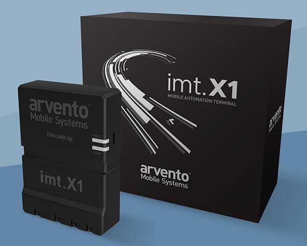
Vehicle tracker
Uses u-blox to detect panic breaking
Photo: u-blox
Arvento’s imt.x1 has a six-axis gyro sensor that can sense three-dimensional movement caused by emergency acceleration, panic braking and directional yaw and drift. With connectivity options including dual CANBus and Bluetooth, the system is eCall compatible and captures and provides data for accident analysis and other vehicle tracking functions. The system also uses the next-generation powerful Arm-based microcontroller. The system’s high position sensitivity and accuracy are based on integration of u-blox’s 2G, 4G and 5G-ready cellular modules as well as GNSS modules.
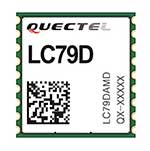
The compact LC79D module features concurrent multi-constellation GNSS receivers on dual GNSS bands. It uses L1 and L5 for GPS, Galileo and QZSS, L1 band for GLONASS and BeiDou, and L5 band for IRNSS. It can generally increase the number of visible satellites, significantly improve positioning drifting when driving in urban canyons and enhance positioning accuracy. Embedded with a low-noise amplifier (LNA) and multi-tone active interference, the module provides high sensitivity and reliable anti-jamming capability, ensuring exceptional acquisition and tracking even in weak signal areas.
The mosaic development kit helps integrate mosaic into an existing system. Mosaic is a compact high-precision multi-frequency GPS/GNSS module that brings precision and reliability of high-end multi-frequency GNSS to mass-market applications. Its light weight and low power consumption makes mosaic suitable for robotics, automation, telematics and wearables. The kit supports connectivity through internet, COM ports, USB 2.0 and an SD Card slot. Mosaic provides Advanced Interference Mitigation (AIM+); extensive corrections support for high-accuracy positioning; integrity needed for safety-critical applications such as autonomous vehicles; and a 100-Hz update rate, suitable for robotics and fast-moving vehicles.
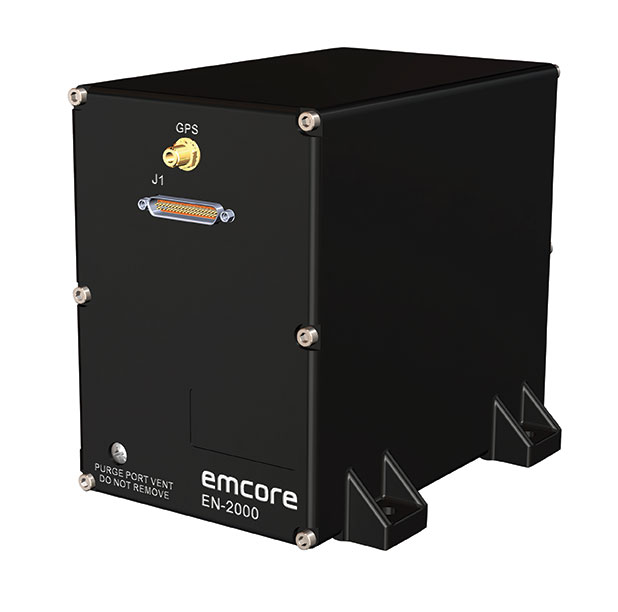
The EN-2000 is the newest addition to the Emcore-Orion series of micro-inertial navigation (MINAV) systems. It is compact and lightweight, weighing less than 7 pounds, with very low power consumption of 10 watts. It can deliver twice the performance of the EN-1000 with the same form factor. With its low size, weight and power (SWaP), the compact EN-2000 is suitable for unmanned aerial vehicles, unmanned underwater vehicles, unmanned ground vehicles, manned aircraft, rotorcraft and dismounted soldier applications. Its three-axis design uses a solid-state optical transceiver with advanced integrated optics, combined with new field programmable gate array (FPGA) electronics to deliver stand-alone aircraft-grade navigator performance at one-third the SWaP of legacy systems.
The Miniature PLGR Engine – M-Code (MPE-M) GPS receiver is a small Type II form factor ground receiver, and incorporates the company’s recently certified Common GPS Module (CGM). As a drop-in replacement for the thousands of customers using Collins’ Miniature PLGR Engine-SAASM (MPE-S) GPS receiver, the new MPE-M technology provides 10 times stronger anti-jamming capabilities for the direct acquisition of GPS signals than its predecessor. The MPE-M receives the current military Y-code GPS signal along M-code. It provides warfighters with improved security and assured positioning, and it satisfies the U.S. government’s requirement for all military GPS equipment to be M-code capable. It is designed for lightweight, ground-based applications such as radios, blue force trackers, targeting devices, vehicle line-replaceable units (LRUs) and small unmanned aircraft. The MPE-M’s security certification makes the receiver eligible for export to U.S. allies through the Foreign Military Sales (FMS) program.
The Catalyst software-defined GNSS receiver for Android phones and tablets is now available with a usage-based service plan: Trimble Catalyst On Demand. The new service plan meets the needs of industries and organizations that need a more flexible payment model. Organizations use Catalyst to record positions, navigate to points, measure relative distance and create digital maps. Trimble Catalyst On Demand provides scalable access to real-time kinematic (RTK)-quality GNSS positioning using a pay-per-use hourly pricing model in addition to the current Catalyst monthly plans. The service also enables automated domain-level email address access, which streamlines license allocation for organizations with a large number of users. (Pictured: Catalyst DA1 antenna).
The DT301X is designed for 3D mapping. Its Intel RealSense Depth camera provides real-time 3D imaging combined with a dual-frequency GNSS module for real-time mapping and positioning. The digital images are better than high-definition standard, and are suitable for construction building information management (BIM) graphics. The highly durable IP65 and MIL-STD-810G-rated tablet in a slim case can be used in the field, office and vehicles. A bright 10.1-inch touchscreen provides indoor/outdoor viewing. The tablet includes long-range Bluetooth and 4G LTE mobile broadband for the latest in high-speed communications. An Intel 8th-generation Core i5 or i7 processor offers high performance while still being energy efficient.
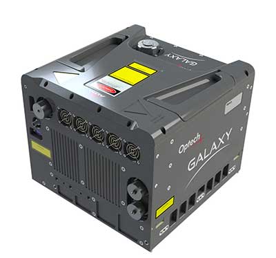
Mapper for wide-area, mountain, urban and corridor surveys
Photo: Teledyne Optech
The ALTM Galaxy PRIME wide-area lidar sensor offers collection efficiency, a small form factor and high-quality data sets that meet rigorous USGS lidar standards. It has a 6,000-meter above-ground-level (AGL) collection envelope and 1-MHz on-ground collection rate. Galaxy PRIME includes lidar technology enhancements to increase sensor performance and collection efficiency, improve data quality, and simplify the collection process. It can be used either gyro-stabilized or fixed-mounted, one camera or six, and full waveform or discrete. PulseTRAK technology enables a continuous operating envelope by eliminating data coverage gaps and irregular point density. Applications include wide-area mapping, urban mapping, natural resource management, engineering, infrastructure modeling, and powerline and transportation corridors.
The Leica BLK247 real-time reality-capture device uses sensor fusion technology to detect and report physical changes within a space. It is designed for continuous 3D reality capture, extending capabilities for safety and security applications. The sensor provides real-time situational awareness through edge computing and lidar-enabled change-detection technology. Using artificial intelligence, the BLK247 can tell the difference between still and moving objects — such as a person walking who leaves a suitcase behind — and identify security threats to provide real-time alerts.
Version 15 of Grapher has new capabilities to improve the ability to model, analyze and interpret data as well as communicate the results. Grapher users can now access new Fit Curve, Axes and Statistical Plotting capabilities. Also, users are provided greater color customization functions in the latest release. Enhancements give Grapher users a more powerful ability to display and communicate the results of their work to others. The software provides 80 different 2D and 3D plot types for analyzing and displaying scientific data.
The Harris Aerial H4/H6 Hybrid multicopter is now offered as an integrated package with any Lidar USA scanning system. The Harris Hybrid can provide longer flights with lidar and industrial-grade cameras. The Harris Hybrids use a small generator running on 95 or higher octane fuel to power the UAV for up to five hours.The H6 can carry an A-series high-definition lidar system of 3 kg for 2.5 hours and a V-series of 5 kg up to 1.5 hours. For the lidar operator, this means most projects will require only one or two flights.
The US-1 was built with sensitive enterprise and government customers in mind. It was designed from the ground up in the United States with a battery-first approach to enable electric aircraft to compete with conventionally fueled incumbents. The US-1 runs on a secure open-source operating system by Auterion. It provides 78 minutes of flight time and high-resolution optical and thermal cameras. US-1 UAVs have been deployed to fight fires, locate pipeline leaks, and track armed suspects.
Impossible Aerospace, impossible.aero
The DRS-M600 reusable parachute safety solution, developed for DJI M600 and DJI M600 Pro, meets specifications of the ASTM F3322-18 standard. The successful completion of the ASTM standard test makes it possible for the Federal Aviation Administration to issue permits for its use on drones over crowds. The ASTM F3322-18 standard is the first standard for parachute systems designed specifically for small UAVs.
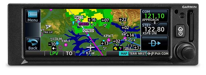
The GNC 355 is a GPS navigator with localizer performance with vertical (LPV) approach guidance. (Photo: Garmin)
The GNS 355 GPS navigator with localizer performance with vertical (LPV) approach guidance gives pilots the benefits of WAAS/SBAS GPS guidance with a modern communications radio. Intended for Class I/II aircraft that weigh 6,000 lbs./2,721 kg. or less, the GNC 355 is certified for more than 700 aircraft makes and models. Aircraft owners can incorporate the GNC 355 into an existing avionics stack because of its standard 6.25-inch wide by 2-inch tall design. The responsive touchscreen display allows pilots to quickly access direct-to functionality, moving map, flight plan, nearest, procedures, waypoint and terrain pages and create customizable data fields and shortcuts for quick, one-touch access to important information. Fully WAAS/SBAS IFR-approach-capable, the GNC 355 gives pilots the benefit of flying LPV, as well as Area Navigation (RNAV) approaches. Many approaches offer vertical approach guidance as low as 200-feet above ground level (AGL).
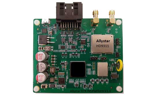
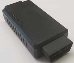
The Allystar INS Platform is a dual-antenna, multi-frequency, multi-GNSS inertial navigation system (INS) that delivers accurate and reliable position, velocity and orientation. It combines high-grade, six-axis, temperature-calibrated accelerometers and gyroscopes with a multi-frequency, multi-GNSS engine, the HD9300 series. The HD9300 is a dual-antenna chip-grade real-time kinematic (RTK) GNSS receiver for accurate positioning and heading. The Allystar INS platform contains an on-board sensor-fusion filter, plus navigation and calibration algorithms for different dynamic motions of land vehicles. The Allystar OBD Data Adapter (v1.0) enables users to read and monitor various sensors built into cars, obtaining real-time vehicle speed and gear signals from the on-board diagnostics (OBD) interface, and then output AT (attention) commands by serial port or serial peripheral interface (SPI).
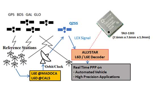
Allystar Technology Co. has launched its QZSS L6 decoder technology in module TAU-1303, which supports tracking the QZSS signals L6D (CLAS) and L6E (MADOCA).
The Quasi-Zenith Satellite System (QZSS) satellite positioning system is operated by Japan as complementary to and an augmentation for GPS. The four satellites in the system broadcast the L6 signal, including L6D and L6E.
CLAS — the Centimeter-Level Augmentation Service — is provided through the L6(D1) signal, and the experimental augmentation service with MADOCA (Multi-GNSS Advanced Demonstration tool for Orbit and Clock Analysis) is provided through L6(D2) signal.
For QZSS, which will be fully operational in the future, Allystar’s latest solution can decode the corrections data broadcast from L6D and L6E signals, and assist developers in applying the centimeter-level accuracy by PPP-RTK algorithm with the correction data, according to Justin Yang, Allystar product manager.
Within its 7.6 x 7.6-millimeter tiny size, the TAU-1303 module provides six dedicated tracking channels to support tracking L6D and L6E at the same time.
For professional applications, the TAU1303 comes with built-in support for standard RTCM Protocol (MSM) and Proprietary Protocol, supporting 2,000 bits per second QZSS L6 raw data output directly for third-party integration and application.
CLAS on L6D channel provides the following error corrections: satellite clock, orbit, code bias, phase bias ionospheric delay and tropospheric delay. MADOCA on L6E channel provides the following error corrections: satellite clock, orbit, code bias and phase bias.
Allystar TAU-1303 offers superior performance thanks to an on-board 26-MHz temperature-compensated crystal oscillator (TCXO) and a reduced time to first fix because of its dedicated 32-KHz real-time clock oscillator. Based on 40-nanometer manufacturing processes of the Cynosure III GNSS chipset, the TAU-1303 has very low power consumption of less than 40 mA at 3.3V.
Engineering samples are available.
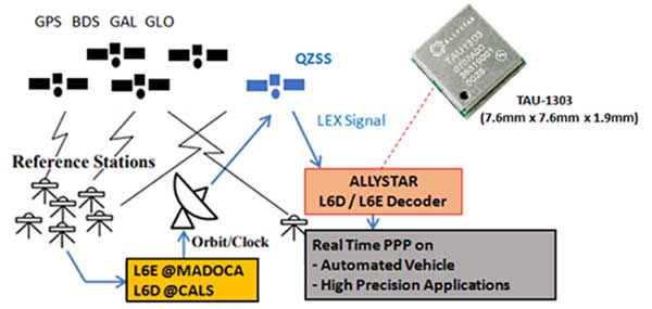
How Allystar’s QZSS L6 Decoder TAU1303 operates. (Diagram: Allystar)
The Allystar INS Platform — the company’s latest technology — is a dual-antenna, multi-frequency, multi-GNSS inertial navigation system (INS) that delivers accurate and reliable position, velocity and orientation, the company said.
It is designed for a wide range of autonomous vehicle applications under the most demanding conditions.
The Allystar INS Platform combines high-grade, six-axis, temperature-calibrated accelerometers and gyroscopes with a multi-frequency, multi-GNSS engine, the HD9300 series. HD9300 is a dual-antenna chip-grade real-time kinematic (RTK) GNSS receiver for accurate positioning and heading.
GNSS-aided inertial navigation systems are widely used in autonomous vehicles. However, high-accuracy multi-frequency multi-GNSS receivers are usually too expensive for mass-market applications. The Allystar HD9300 series is a mass-market multi-band chip-grade receiver that concurrently support all civil bands in all GNSS constellations (GPS/QZS L1&L2&L5&L6, BDS B1&B2&B3, GAL E1&E5, GLO L1OF/L2OF) with an integrated RTK engine to achieve centimeter-level accuracy.
The Allystar INS platform contains an on-board sensor-fusion filter, navigation and calibration algorithms for different dynamic motions of land vehicles. Key features include:
multi-band multi-GNSS chip-grade receiver
dual antennas
integrated RTK engine (up to 2 centimeters)
100-hz update rate
OBD data adapter.
Allystar OBD Data Adaptor V1. (Photo: Allystar)
The Allystar OBD Data Adapter (v1.0) enables users to read and monitor various sensors built into cars, obtaining the real-time vehicle speed and gear signals from the OBD interface, and then output AT commands by serial port or SPI. When connected to the Allystar RTK INS platform, the adapter allows for outstanding navigation accuracy, especially in urban areas, helping to increase accuracy and reduce position drift.
An evaluation kit — including platform board, antenna and OBD adaptor — will be available in August.
The latest Lenovo smartphone offers dual-frequency GNSS capable of tracking the latest BDS phase III signal, the Z6 SE, using an Allystar chipset.
The company says this is the first time a smartphone supports the new BeiDou signal.
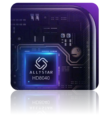
HD8040 series SoC. (Photo: Allystar)
Fitted with a Allystar HD8040 series chipset, the Lenovo Z6 youth edition provides position accuracy up to sub-meter, according to Allystar.
The HD8040 series chipset supports all civil signals on the L5 band. Besides GPS/QZS L5 and GAL E5a, the latest BDS phase III signal B2a has already been implemented to maximize the visible satellites in L5 band.
Dual-frequency GNSS means that the receiver tracks more than one radio signal from each satellite on different frequencies — GPS L1 and L5, Galileo E1 and E5a, and Beidou B1 and B2a.
B2a will replace B2I and broadcast on MEO and IGSO satellites. The code lengths are 10230, which have better anti-cross-correlation performance and are designed separated pilot component and data component to improve tracking sensitivity.
In general navigation scenarios, multipath error lead to positioning inaccuracy of up to several meters, caused by to signals bouncing off of higher buildings. The error caused by multipath can be nullified and mitigated by using two frequencies instead of one in urban areas. Under a relatively open-sky environment, measurement error caused by the ionosphere is usually eliminated by a linear combination of dual frequencies to easily achieve sub-meter accuracy.
“Allystar is glad to boost the smartphones and Internet of Things (IoT) applications with the latest multi-frequency GNSS SoC (system on chip) technology,” said Shi Xian Yang, the product and marketing manager in Allystar.
Lenovo smartphone Z6 SE has Allystar inside. (Photo: Lenovo/Allystar)
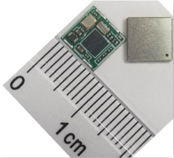
Allystar Technology Co. Ltd. has launched its smallest multi-band multi-GNSS module, the TAU-0707. Within its 7.6 x 7.6 millimeter size, the TAU-0707 series module supports major GNSS constellations (GPS / Galileo / GLONASS / BeiDou / QZSS / IRNSS) and all civil bands (L1, L2, L5, L6).
As the latest addition to Allystar’s GNSS portfolio, the TAU-0707 series module is a concurrent multi-band multi-GNSS receiver embedded with a cynosure III single-die standalone positioning chipset, which offers multi-frequency measurements to improve positioning accuracy and simplifies integration for third-party applications, said Shi Xian Yang, Allystar marketing manager.
Moreover, Allystar also provides the built-in low-noise amplifier in the TAU-1010 series module, which offers the module with improved RF sensitivity and exceptional acquisition and tracking performance even in weak signal areas.
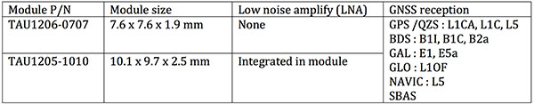
With more and more satellites supporting L1/L5 signals, Allystar offers two modules to fully support all civil signals on the L5 band for the standalone market. The TAU1206-0707 and TAU1205-1010 are expected to be better in multipath mitigation mainly due to the higher chipping rate of L5 signals relative to L1 C/A code.
L1/L5 band module for standalone market.
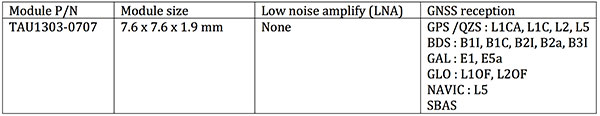
For professional applications, module TAU1303-0707 comes with built-in support for standard RTCM protocol (MSM), supporting multi-band multi-system high-precision raw data output, including pseudorange, phase range, Doppler, SNR for any kind of third-party integration and application.
Module with Raw data output for professional market.
Allystar TAU series module offers superior accuracy thanks to the onboard 26-MHz temperature compensated crystal oscillator and a reduced time to first fix relying on its dedicated 32-KHz real-time clock oscillator. Based on 40-nm manufacturing processes of the Cynosure III GNSS chipset, it comes with very low power consumption at less than 40 mA.
According to the company, engineering samples and a reference design of the Allystar TAU-0707 and TAU-1010 series module will be available in April.
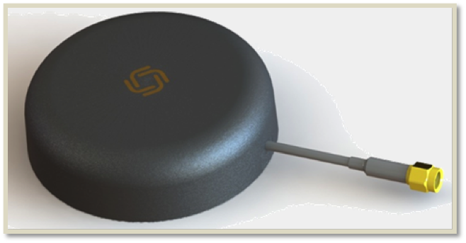
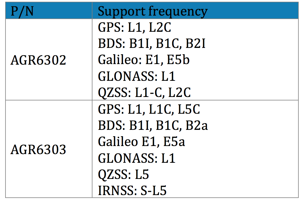
Allystar Technology Co. Ltd., headquartered in Shenzhen, China, is offering new patch antennas: the AGR6302 and AGR6303. Both GNSS antenna models are designed for precision dual-frequency positioning.
AGR6302 is capable of receiving L1/L2 bands, and AGR6303 is capable of receiving L1/L5 bands. They are designed for UAVs, precision agriculture, autonomous vehicles and other applications where precision matters.
The AGR6302/AGR6303 active antenna is designed by unique technology to cover GPS, BDS, Galileo, GLONASS, IRNSS and the QZSS system (see table).
Table: Allystar
The antenna features stable signal quality at low cost. It employs a stack four-feeds antenna architecture with hybrid to achieve the multi-band operation, lower axial ratio, wider half-power beamwidth and excellent right-hand circular polarization, the company said.
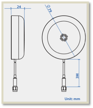
Antenna size. (Image: Allystar)
With its new architecture, the active part has two stages. It has two level low noise amplifiers (LNAs) —one for the lower bands, the other for the higher bands. Then, the combiner and the third-level LNA output the RF gain to receiver. With this architecture, the antenna provides an excellent noise figure/RF linear and LNA gain, and out-band rejection, resulting in good signal-to-noise ratio and anti-interference.
It is housed in a compact, industrial-grade waterproof and magnet mount enclosure. Using internal magnets, the antenna can be installed almost anywhere, allowing for greater flexibility.
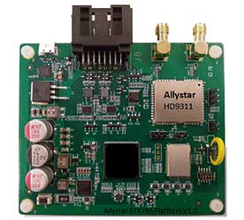
Allystar’s Yi Fen Tseng discusses the company’s HD9300 series precision positioning Cynosure III GNSS chip and high precision GNSS family at ION GNSS+ 2018, which took place in Miami. According to the company, the HD9300 series is a highly integrated GNSS receiver chip based on its Cynosure III architecture, integrating multi-band, multi-system, GNSS, RF and baseband. In addition, the company showcased its A GR6301 single-band GNSS antenna and A GR6302/A GR6303/A GR630X high-precision dual-band GNSS antenna.