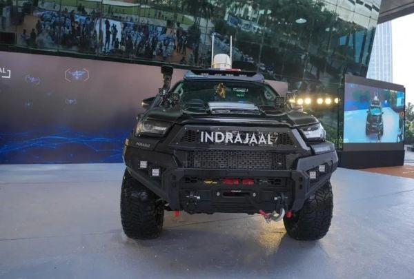
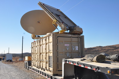
Indrajaal Drone Defence has launched the Anti-Drone Patrol Vehicle (ADPV) — a fully mobile AI-enabled counter-drone system designed to redefine how India responds to drone-led threats.
The Ranger has both soft- and hard-kill options. A GNSS spoofer can hijack drones remotely, while its Zombee interceptor drone provides a kinetic strike capability. Together, the sensors and weapons deliver a 10-kilometer (6.2-mile) detection range and a combat radius exceeding 4 kilometers (2.5 miles).
The urgency to build the ADPV (Indrajaal Ranger) was reinforced when two recent national security incidents demonstrated how drones have become a critical link in breaching India’s border security.
First was a drone-trafficking incident, where weapons were smuggled deep into Indian territory from Pakistan. Second, the Border Security Force neutralized 255 Pakistani drones in 2025, underscoring how drones have become the primary transport channel for drug trafficking.
Breaking away from traditional vehicle-mounted anti-drone solutions that work only when parked, Indrajaal engineered the ADPV ( Indrajaal Ranger) as a purpose-built combat vehicle that delivers:
On-the-move drone detection
Real-time patroling and surveillance
Autonomous threat assessment through AI
Instant interception and neutralization
Seamless coverage across border roads, canals, agricultural belts, critical infrastructure and dense urban pockets.
By intercepting hostile drones, the Indrajaal Ranger prevents narcotics from entering and endangering Indian lives, blocks the inflow of illicit weapons into urban centers, and protects farmers living along sensitive border zones, the company said. Its automated interception framework is designed to reduce the operational load on police units, enabling smarter, data-driven deployment of manpower.
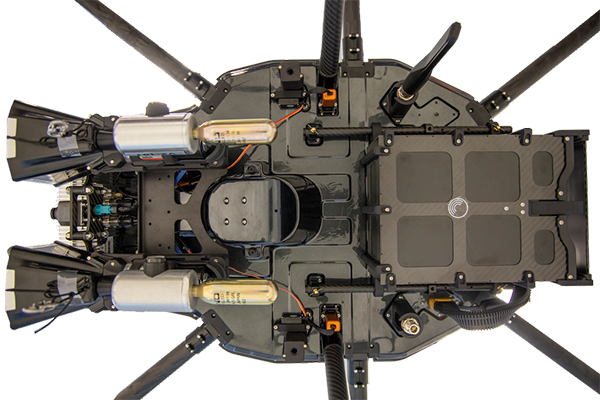
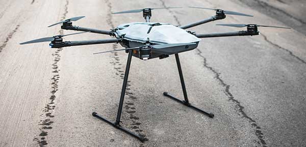
DroneHunter F700 is a radar-based autonomous interceptor drone for tracking and stopping dangerous drones
Fortem Technologies Inc. is now shipping its artificial intelligence (AI)-enabled F700 DroneHunter. The F700 is a safe, effective deterrent against a rising number of careless and criminal drones, the company said.
The F700 has a flexible undercarriage that offers interchangeable counter measures for single, multiple or swarm-based threats. Its new lightweight carbon-fiber frame enables greater athleticism and speed.
The F700 can carry multiple types of anti-drone countermeasures and deploy them in real-time, based on the dynamic threat detected miles beyond the protected area. The undercarriage features pogo pins and payload snaps integrated with AI-enabled firing and flight software.
Underside of the DroneHunter F700. (Photo: Fortem Technologies)Photo:
The F700 offers significant payload capacity to handle situations over civilians where zero collateral damage is required. AI decisions are now made in real-time to select the appropriate effectors for the detected threat. Complex algorithms for flying in urban areas are now supported. Heavier drones are tethered or parachuted with controlled descent into predetermined safe zones.
The F700 is equipped with ground- and airborne-networked radar and corresponding optics, giving users total situational awareness and autonomous precision. F700 is custom designed and manufactured in the United States.
“We have advanced the DroneHunter F700 so that it can deliver any ordinance necessary to stop drones and to protect stadiums, refineries, campuses and entire metro regions,” said Fortem Technologies CEO, Timothy Bean.
Fortem is developing several DroneHunter mitigation types, including directed energy.
Centum Solutions of Madrid, Spain, introduced its NO JAM ZONE interference detector ION GNSS+ in Miami.
NO JAM ZONE is Centum’s solution for GPS interferences detection and location.
Centum will have a booth in the ION GNSS+ exhibit hall to showcase NO JAM ZONE, as well as and a GNSS simulator to show the process of detection and location of different sources of interference.
Critical infrastructures need to ensure the proper functioning of their radio frequency systems. A good example of this is airports. NO JAM ZONE is a GNSS spectrum monitoring system, capable of detecting interferences that affect the proper functioning of these systems.
NO JAM ZONE works with the most-used GNSS frequencies. Because of its distributed network of beacons, the system is able to give, in real time, the position of a source of interference.
NO JAM ZONE can detect the following types of interference:
Service interruption (jamming)
Spoofing interference
Induced electromagnetic emissions whose power exceeds a certain harmful threshold
Centum also offers the NO FLY ZRONE drone and remotely piloted aircraft system (RPAS) detection and protection system. The active defense system is capable of detecting threats and creating a shield of electronic countermeasures preventing the intrusion of drones in protected areas and diverting them to safe catch areas.
NO FLY ZRONE is effective against the vast majority of drones and RPAS, whether radio-controlled by an operator or by autonomous guidance through GPS. It detects drones and discriminates against those that constitute potential threats.
Once the threat has been classified, NO FLY ZRONE neutralizes the drone control system by taking control of it and driving it to a safe area for its descent and capture; it can also geolocate the operator of the drone.
Two drones armed with explosives detonated near Venezuelan President Nicolas Maduro on Aug. 4 in an apparent assassination attempt that took place while he was delivering a speech to hundreds of soldiers, while the speech was being broadcast live on television, according to press reports.
The footage of this apparent assassination attempt can be viewed below.
Drone security solutions company DroneShield issued a statement about the incident.
“The history of commercial drone incidents involving heads of state goes back to September 2013 when the German Chancellor Angela Merkel’s public appearance was disrupted by a drone, which was apparently a publicity stunt by a competing political party,” said Oleg Vornik, DroneShield’s CEO.
“Yesterday’s apparent drone assassination attempt on Venezuelan President Maduro is the first known drone attack on a head of state. An attempted drone assassination of a sitting sovereign leader demonstrates that, sadly, the era of drone terrorism has well and truly arrived,” Vornik said.
“Technological progress cannot be reversed, and going forward, the security of any asset whose perimeter is protected two-dimensionally on the ground will need to be also protected in the third dimension — from attacks from the air,” Vornik added.
DroneShield supplies counterdrone (counter unmanned aerial system/counter unmanned aerial vehicle/c-UAS) products, which have been successfully deployed in a variety of situations by third parties.
The company’s products have been deployed for counterdrone security at, among others:
an ASEAN meeting of heads of state,
several Boston Marathon events over the years,
the PyeongChang 2018 Olympics and
the 2018 XXI Commonwealth Games.
Also, a Middle Eastern ministry of defense recently placed a multi-million dollar order for DroneShield’s anti-drone equipment.
The company expect that this latest incident involving a head of state will result in governments around the world accelerating their implementation of anti-drone mitigation measures.
A news story from Australia’s “Today Tonight Adelaide” television show highlights how the DroneShield system can bring down drones that enter restricted airspace or threaten safety. DroneShield countermeasures allow for the controlled management of drone payloads such as explosives, with no damage to common drone models or the surrounding environment.
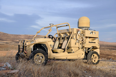
Forty-five unmanned aerial vehicles and drones fell out of the sky during a U.S. Army exercise after Raytheon’s advanced high-power microwave and laser dune buggy engaged and destroyed them.
These common threats were knocked down during a Maneuver Fires Integrated Experiment (MFIX), held in December at the Fires Center of Excellence at Fort Sill, Oklahoma.
The directed energy system emits an adjustable energy beam that renders drones unable to fly. (Photo: U.S. Army)
The directed energy system emits an adjustable energy beam that, when aimed at airborne targets such as drones, renders them unable to fly.
The MFIX event brought military and industry leaders together to demonstrate ways to bridge the Army’s capability gaps in long-range fires and maneuver short-range air defense.
Raytheon’s high-power microwave system engaged multiple UAV swarms, downing 33 drones, two and three at a time.
Raytheon’s high-energy laser, or HEL, system identified, tracked, engaged and killed 12 airborne, maneuvering Class I and II UAVs, and destroyed six stationary mortar projectiles.
The vehicle-mounted laser is installed on an all-terrain Polaris militarized vehicle. (Photo: U.S. Army)
The vehicle-mounted laser combined a solid state laser with an advanced variant of the company’s Multi-Spectral Targeting System and installed them on a small, all-terrain Polaris militarized vehicle.
The system delivers 300 seconds of invisible, precise and instantaneous energy and five hours of intelligence, surveillance and reconnaissance from a single charge, Raytheon said.
Coupled with a generator, the HEL weapon system provides military members with counter-UAV capabilities and a virtually unlimited magazine.
“The speed and low cost per engagement of directed energy is revolutionary in protecting our troops against drones,” said Thomas Bussing, Raytheon Advanced Missile Systems vice president. “We have spent decades perfecting the high-power microwave system, which may soon give our military a significant advantage against this proliferating threat.”
Raytheon and the U.S. Air Force Research Laboratory worked together under a $2 million contract to test and demonstrate high-power microwave, counter-UAV capabilities.
“Our customer needed a solution, and they needed it fast,” said Ben Allison, director of Raytheon’s HEL product line. “So, we took what we’ve learned and combined it with combat-proven components to rapidly deliver a small, self-contained and easily deployed counter-UAV system.”
Drones have become a serious threat, able to penetrate airspace for surveillance or with an explosive payload.
The Islamic State has used weaponized drones against both Syrian and Iraqi forces; groups like Hezbollah and Hamas have sent drones into Israel and are said to be working on upgrading their UAVs for use in both intelligence gathering and offensive operations.
On April 27, Israel used a Patriot missile to take down a drone entering Israeli Airspace from Syria. At $3 million per missile, the Patriot system is an expensive way to down a device that may only be worth $200. Israel has also intercepted drones with fighter jets.
Systems developed by two Israeli companies provide less expensive — and quickly reactive — solutions.
The Drone Dome system uses Laser, RF and Radar. (Photo: Rafael)
Drone Dome.Rafael Advanced Defense Systems Ltd. has developed a radar and laser-beam system for detecting and destroying drones, with the company adapting its existing laser systems to handle the threat.
Once the system’s radar identifies targets, its laser system destroys them.
Drone Dome also features a jamming system for disrupting communications between the drone and its operator. Drone Dome’s range reaches several miles, but causes minimal interruptions to other systems in nearby urban areas.
The standard Drone Dome system comprises a RADA RPS-42 S-band multi-mission hemispheric radar, a Controp MEOS electro-optical (EO)/infrared surveillance suite, a communications package, and the C-Guard RD jamming and NetSense Wideband detection sensor systems developed by Netline. The UAV threat is neutralized by activation of directional GPS/GNSS and radio-frequency inhibitor/jammer devices.
The RPS-42 is a four-panel tactical air surveillance system delivering 360-degree coverage in azimuth and 90 degrees in elevation, with a detection range of 30 kilometers — including the detection of a minimum target size of 0.002 meters square at a range of 3.2 kilometers — at altitudes from 30 to 30,000 feet. The RPS-42 is designed to detect, track and classify all classes of UAV.
DROM Defense.ORAD’s DROM Drone Defense System can detect an approaching drone at more than 3.5 kilometers away and take command, neutralizing it and landing it far from the operator.
With a weight of 38 kilograms, ORAD’s DROM system comes pre-engineered and pre-assembled. It is mobile and easily deployed on land or at sea in any weather conditions and has an effective coverage range of 3.5 kilometers. It has a 2-kilometer neutralization capability.
Once intercepted, the system can land a hostile a UAV in a pre-defined location, keeping any intelligence it gathered out of enemy hands. It can also identify the location of the operator.
The system’s RF detection unit analyzes signal channels and radio transmissions to spot drones. Once detected, an alarm alerts the system operator.
ORAD has sold the system to clients in several countries including Portugal, Spain and Thailand. The company is in talks with Israeli agencies interested in purchasing the system.
The global anti-drone market size is anticipated to reach $1.85 billion by 2024, according to a new report by Grand View Research Inc.
The increase in the adoption of UAVs (drones) has resulted in the commencement of another market that focuses on a solution for rogue drones, complete with net-firing bazookas, electromagnetic shields and anti-drone death rays.
U.S. anti-drone market, by destructive mitigation type, 2014-2024 (USD million).
The steep rise in the adoption of drones for commercial as well as recreational purposes has increased concerns regarding aerials attack and threats. Detection and identification of these unmanned aircraft systems have become a vital factor for the maintenance of the security. Various institutions across the world are increasingly deploying counter drone measures to address the ever-growing need for safety and security.
As UAVs become deadlier, stealthier, faster, agile, smaller, sleeker and cheaper, the nuisance and threats posed by them are expected to grow at numerous levels, ranging from personal/domestic privacy to national security. With that in mind, there is significant effort both in terms of money and technology being invested in the development of anti-drone technologies.
Various national security agencies across the world have started to precisely understand the potential threats from drones and increasingly considering commercial as well as consumer drones as the new major threat to the world. It is only a matter of time before redundant and reliable methods of countering drones become mainstream and widely available.
Several busy airports and hubs across the world are seeking defense measures and regulations to protect their airliners and harbored aircraft from drones straying into commercial airspace and posing innumerable threats of a collision. The detection of a range of drone types is expected to require multiple modalities, data fusion systems to effectively identify and detect target drones amongst a cluttered background.
The full research report with a table of contents is titled “Anti-Drone Market Analysis By Mitigation Type (Destructive, Non-Destructive), By Defense Type (Detection & Disruption, Detection), By End-Use (Military & Defense, Commercial, Government), By Region, And Segment Forecasts, 2014 – 2024.”
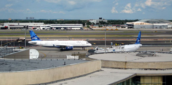
The United States Federal Aviation Administration (FAA) and its government partners are expanding research on ways to detect “rogue” drones around airports. Together, they are evaluating drone detection technology at John F. Kennedy International Airport (JFK) in New York.
Over the last two years, the FAA has received numerous reports from pilots and residents about unmanned aircraft systems — UAS, or “drones” — around some of the nation’s busiest airports, including JFK.
“We face many difficult challenges as we integrate rapidly evolving UAS technology into our complex and highly regulated airspace,” said Marke “Hoot” Gibson, FAA senior advisor on UAS integration. “This effort at JFK reflects everyone’s commitment to safety.”
Terminal 6 at JFK Airport. (Photo: New York Photo Gallery)
Beginning May 2, the FAA conducted evaluations at JFK to study the effectiveness of a Federal Bureau of Investigation (FBI) UAS detection system in a commercial airport environment. Five different rotorcraft and fixed-wing UAS participated in the evaluations, and about 40 separate tests took place.
The JFK evaluation involved extensive government inter-agency collaboration, and cooperation from industry and academia. The tests expanded on research performed earlier this year at Atlantic City International Airport.
In addition to the FAA and the FBI, the agencies combining forces in this research included the Department of Homeland Security (DHS), Department of Justice, Queens District Attorney’s Office and the Port Authority of New York and New Jersey. DHS and the FBI want to identify unauthorized UAS operators for law enforcement purposes, and the FAA’s mission is to provide a safe and efficient airport environment for both manned and unmanned air traffic.
“We applaud the FBI and FAA for their efforts to detect and track unmanned aerial systems (UAS),” said Thomas Bosco, Port Authority aviation director. “We look forward to supporting continued U.S. government efforts to identify and deploy countermeasures to neutralize the threat posed by rogue UASs.”
The team evaluating the FBI’s detection system also included contributions from one of the six FAA-designated UAS test sites. The Griffiss International Airport test site in Rome, New York, provided expertise in planning the individual tests as well as the flight commander for the tests and two of the UAS used.
The FY 2016 Appropriations law mandates that the FAA continue research into detection of UAS in airport environments. The agency is continuing to formulate an inter-agency strategy to evaluate detection systems in a variety of airport environments.
This month’s column recaps UAV news that you may or may not have picked up over the last few weeks. We start with stories related to the rules for operating drones in the U.S., then we’ll look at bird-like drones — used to scare away birds, new commercial UAV applications, and steps being taken to protect us from malicious use of drones and other possible “impacts” of drones.
Who owns the air?
A long time back, the U.S. Congress passed laws which gave the government control above 500 feet and limited land rights so that overflying aircraft could not be considered as trespassing over private property. But, it turns out, ownership of the airspace from the ground up to 500 feet may not be that clear.
The Federal Aviation Administration (FAA) recently reaffirmed that the agency controls all U.S. airspace, even right down to the ground, but it seems that landowners may still have some claim to their own air directly above their property.
In a precedent-setting case dating back to World War II, the U.S. Supreme Court said that landowners have rights to as much airspace as they can use for the enjoyment and use of their land. So if “enjoyment and use” entails flying a UAV at up to 500 feet above their property or alternatively requires no UAVs flying above their own roof-line, who’s rights prevail?
Certainly, there seems to be a number of people who are not too fond of UAVs being allowed to fly over their homes at low altitude. Manned aircraft might be a different kettle of fish as they generally fly higher and don’t seem to bug most people as much. And noise abatement regulations attempt to limit the sound of loud aircraft engines on landing and take-off.
But with this continuing ambiguity, several state and local governments have already begun to take steps to protect airspace over people’s homes.
There are currently more than 150 active bills in more than 30 states — either carried over from 2015 or introduced this year.
Indeed, the FAA, in an effort to dissuade such lawmaking activity, recently released a fact sheet on state and local drone regulations: “Navigable airspace free from inconsistent state and local restrictions is essential to the maintenance of a safe-and-sound air transportation system,” said the FAA. The agency urged local and state lawmakers to consult it before making any new regulations. And it would clearly be far better for drone manufacturers and operators if there was only one set of (FAA) regulations across the whole U.S., rather than each user having to navigate a tangled web of potentially conflicting local and state regulations.
In the meantime, there has been at least one case in which a property owner sought to protect his “home and castle” by unloading a shotgun into a low-overflying drone. The lawsuit was settled to the benefit of the property owner, rather than the drone operator, so property rights did prevail in this case.
Nearly 300,000 owners have registered their small unmanned aircraft (sUAV) in the first 30 days using the FAA’s online registration system and have received a refund for the $5 application fee. While the refund period has now expired, the agency continues to see a steady stream of daily registrations.
The FAA’s registration rule, which took effect on December 21, 2015, applies to sUAV that weigh between 0.55 lbs. and 55 lbs. Existing owners of these aircraft must register before Feb. 19, 2016. The current online system only supports use by recreational or hobby operators, while the FAA hopes to provide commercial operators with access by March 21.
Name, address and email are required ,and a registration number and printable certificate are then provided. The registration number must be marked on the UAV.
A drone flies in Russia.
Meanwhile, Russian President Vladimir Putin has signed a law that obliges all private owners of unmanned aircraft weighing more than 250 grams to register them with the Federal Air Transport Agency.
According to the new act, which comes into force at the end of March 2016, owners and operators of unmanned aircraft systems (UAS) must also appoint a crew and a commander responsible for flight safety. In order to operate, a flight plan must be submitted to the regional air traffic controllers — as required for manned aircraft operations — and the flight plan has to be followed unless an emergency landing is necessary when there is a threat to public safety.
Is that a bird or a drone?
But, of course, the more we try to overcome issues related to UAVs, the more complicated it seems to become. A core element of all FAA authorizations to date has been that a drone should never be operated within several miles of an airport to avoid collisions with aircraft. Now, a company has come up with a drone which carries a broadcast sound unit, programmed with a number of hawk, owl and other bird calls — ideal for scaring feeding or roosting birds away from areas we want to clear, such as at airport runways.
Bird strikes by aircraft in the critical phases of landing or take-off are a major concern for airlines and airports alike. Many methods have been tried to reduce birds flying around at the sound of loud aircraft noise. Birds can get sucked into engines or can damage other critical aircraft structures. Air blasts that sound like shotguns and flying live falcons are only a couple of methods used to clear birds away from airport approaches, departures and runways.
Bird-repelling drone.
In the meantime, at least one enterprising associate prof at the University of Illinois has recognized the requirement and is developing a robotic falcon that chases birds away from airfields.
A flying falcon.
Soon-Jo Chung and his team have been supported by funding not only by the National Science Foundation’s CAREER Award program to create the flying falcon above, but also by other sources to develop vision-based navigation. An analytical computer simulation has replicated motion control and avoidance so the robotic falcon can intelligently come up with motion planning algorithms.
And another the twist to this story is that bald eagles and other birds of prey are being trained to hunt and take down drones in the Netherlands. Dutch police have been investigating this natural “anti-drone technology” to combat criminal use of drones, and to counter the prospect of drones being used to deliver bombs or chemical and biological weapons.
UAV inspection/monitoring to reduce costs and enhance safety
A DJI UAV was recently used by Lufthansa Aerial Services to inspect rotor blades on wind turbines. Previously, inspection was somewhat dangerous, and required climbing the wind turbine tower. While cost reduction may be the principle motivation, it’s possible that wind turbine inspection and maintenance periods could also be extended.
And, in partnership with Flot Systems, Xcel Energy has become the first utility company to use drones in beyond-line-of-sight inspection of more than 320,000 miles of electricity and natural gas infrastructure.
Xcel began using UAVs to visually inspect substations in 2015, and is one of the first operations to receive FAA approval for research to use “beyond visual line of sight” for these inspections.
Previously, manned helicopters were contracted that would carry an inspector and would fly along transmission lines. But from a safety viewpoint, flying UAVs near high-voltage lines is less risky for workers and pilots. Transmission line inspectors also used to have to walk through difficult terrain which can also be hazardous.
(Editor’s note: Look for more information on UAV’s used for utility inspections in the March issue of GPS World.)
Another major area that can benefit from the use of drones is agriculture. Remote crop inspection through live and recorded video helps farmers gather much better information to support improved crop growth.
A Hermes 450 may be gathering lots of usable growing crop information this summer, provided an ag project in North Dakota is approved. The UAV can carry up to 400 pounds of sensors and cameras, and collects data at around 92 mph for 14 hours at 8,000 feet, covering 50,000 acres per hour.
Photos and videos of growing corn, sugar beet and other crops have the potential to identify fertility deficiencies, yield estimates, and weed and disease issues. North Dakota State University (NDSU) is collaborating with the Northern Plains UAS Test Site and Elbit Systems of America to conduct the crop project.
The operation is planned to cover a whole county in North Dakota, mostly outside line-of-site of the operator, so in this case a manned aircraft is needed to observe the UAV — it’s a safety condition of the FAA Section 333 approval. Many producers in North Dakota are already buying, registering and flying their own smaller UAVs.
And one drone operator is taking a pro-active approach to help the agriculture industry decide if using drones can help them. Working with the American Farm Bureau Federation, on behalf of several major sponsors, Measure has released what it calls the Drone Flight Calculator.
The Drone Flight Calculator quantifies the economic benefits of using drone services for crop monitoring — such as soy, corn or grapes. When data such as fertilizer use, farm size, and crop type are entered, the calculator provides economic returns by acre and for each growing season. Farmers can also learn how much they can expect to save on inputs such as fertilizer and irrigation.
Drone flies into hurricane
The National Oceanic and Atmospheric Administration (NOAA) has been working with several UAVs to investigate the tracking and modeling of hurricanes. NOAA successfully deployed a Coyote UAV from a P-3 hurricane hunter aircraft into the eye of Hurricane Edouard in the fall of 2014. The Coyote is a small, expendable UAS that can be tube-launched from an aircraft or from the ground.
The seven-pound unmanned aircraft was deployed from a free-fall chute in the belly of the plane, which then opened its six-foot wingspan to fly through the storm. It can be controlled from miles away, but was piloted by scientists onboard the P-3.
A successful calibration flight over Avon Park, Florida, was recently completed, where a Coyote was launched from a P-3 hurricane hunter aircraft to prepare for deployment during storm season.
“This successful flight gives us additional confidence that we will be able to use this unique platform to collect critical continuous observations at altitudes in the storm environment that would otherwise be impossible,” said Joe Cione, a hurricane researcher at NOAA’s Atlantic Oceanographic and Meteorological Laboratory and chief scientist of the Coyote program.
With a particularly military look to it, a consortium of British companies has come up with a system to defeat potential attacks using drones. Dubbed the Anti-UAV Defence System (AUDS), it combines electronic scanning air security radar, a stabilized electro-optic director, infrared and daylight cameras, target tracking software, and a directional radio frequency (RF) inhibitor/jammer system.
Anti-UAV Defence System (AUDS).
The portable system can spot small, slow-moving drones up to four miles away using radar. A military-grade camera then tracks it before jamming the radio signals that control it, making it impossible to fly. The whole process can take as little as 15 seconds.
With incidents of drone-related security breaches occurring regularly, there is a need to address heightened UAV concerns within military, government, critical infrastructure and commercial security organizations. While UAVs have many more positive applications, it’s nevertheless anticipated that they could also be used for terrorism, espionage and smuggling — with cameras, weapons, toxic chemicals, explosives and drugs as potential payloads.
The AUDS technology has apparently been extensively tested in South Korea, at French government trials and in UK government-sponsored counter-UAV trials.
In fact, this system or one very much like it underwent a successful trial at London’s Remembrance Day parade. The system was installed on the roof of Scotland Yard, close to where the Nov. 11 ceremonies took place. Police in the UK are apparently looking for such a device to block drones flown by terrorists at major public and sports events.
Along the same lines, Drone Labs has developed a Drone Detector unit that appears to use audio and radio frequency sensors along with GPS to find not only a drone, but also the location of the operator, over at least a range of 1 kilometer.
Drone Labs plans to add video, thermal and radar detection capabilities. The object is to provide some level of protection from drones used for illegal activities, such as delivering contraband at prisons. Some operations already using the system include movie sets, celebrities and facility management professionals seeking to protect assets and people from intrusive drones, as well as law enforcement. Presumably, criminals might also use such a system to reduce the risk of detection by law enforcement drones.
Crashing drone nearly hits skier
And, while it’s good that we put attention on protecting us from potential drone attacks, it’s unfortunate that we recently witnessed live TV coverage of a drone crash that could have had really bad consequences. In December, one of world’s best Alpine skiers was lucky not to be taken out by a crashing drone carrying a TV camera during a slalom run in Italy. Unfortunately, following the incident, the International Ski Federation (IFS) went on to ban camera drones from its World Cup races.
IFS’s broadcast partner — Infront Sports and Media — has indicated the likelihood that the control link to the UAV may have been lost, possibly due to radio interference. Infront has decided to engage an external independent expert to formally investigate the incident. IFS noted that the drone operator had agreed to maintain a safe 15-meter distance from the ski slope. However, it’s possible this safety margin was not maintained…..err, well, it would seem so! The drone fell directly onto the ski slope!
So, maybe it was some over-zealous operator error along with a technical failure — this can happen with any technology — but hopefully no active jamming was involved. For one, I was happy that nothing broke on the overhead camera-carrying wire-system following the action on the field at the Super Bowl this weekend! (It wasn’t such an exciting game in the end anyway.…)
Almost every day, news about UAVs continues to pour in with updates on regulation, legal aspects of drone operations, new ways to reduce costs by applying drones to an existing task, and privacy and security angles on why and when something should or shouldn’t be done with an unmanned air vehicle. It’s interesting to watch how things develop in this new industry — almost like when GPS was brand-new and just getting started…