Steven Spriggs was pulled over by a motorcycle cop for using his iPhone while driving. He immediately held it up to show the officer that he was using Apple Maps, and not talking or texting. More about Mr. Spriggs later. With approval of the pending transportation bill in Congress, smartphone maps and navigation will be regulated. The National Highway Traffic Safety Administration (NHTSA) would receive the power to regulate apps like Google Maps or Apple Maps. NHTSA’s job would be to review navigation apps and order changes to decrease driver distractibility.
Guess who is in favor of this new regulation for smartphone apps? Automakers. Embedded navigation systems, those found in the dashboard of vehicles, are already regulated by NHTSA. Smartphone navigation apps are a much cheaper option than the systems offered by automakers, who are looking for a more level playing field and a way to slow down the smartphone navigation juggernaut.
The downside to this regulation is big. If it was just Apple and Google mapping, oversight would be simpler, but Apple App Store and Google Play Store are filled with hundreds of mapping and navigation apps. Logistically it doesn’t seem possible for the NHTSA to review all of the apps efficiently without causing interference in the market. NHTSA doesn’t currently have the budget, infrastructure or staffing to be successful.
The forum of the radio show “Car Talk” is alive with discussion on NHTSA’s desire to control navigation. The vast majority of posters point out the distraction from using a paper map or being lost. “Personally, I prefer a full-sized road atlas on the seat beside me for all my navigation needs. Taking occasional readings with a sextant helps, but is difficult while eating my Big Mac and holding the wheel with my knee,” Paul Carney writes with sarcasm. On the other side, Victor Cooper responds, “YES! It is long overdue. And I think it is about time we treat texting while driving the same as we do drunk driving…criminal penalties and all.”
I think regulation on mapping and navigation may help make the apps simpler to use and less distracting. Before passing a regulatory law, I’d like NHTSA to successfully demonstrate a review system that doesn’t impede innovation, significantly delay new products, or make it overwhelming difficult for small start-ups.
So what happened to Steven Spriggs? The police officer went ahead and wrote a $165 ticket for using a cell phone while driving, despite Spriggs argument that the law didn’t apply to navigation apps. Spriggs challenged his ticket in California’s state appeal court and won. The $165 went back into Spriggs’ pocket and map users everywhere sighed with relief,
When one talks about the worldwide location industry, mobile resource management — fleets and trucks, for instance — aren’t sexy at all, but they make money. What is supposed to be sexy is location-based advertising. According to many analysts, location-based advertising has been hampered by a few things: education for both consumers and mobile advertisers, privacy issues, and relevant proximity information so folks can use it to make purchases. Another concern could be the expense of rolling out indoor beacons.
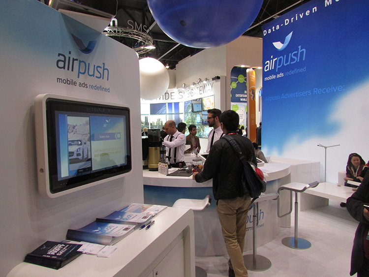
BARCELONA—Major consumer privacy concerns aside, companies are starting to see growth in location-based advertising, with new markets emerging in Europe. While the numbers of mobile advertising companies has decreased at the Mobile World Congress, held here in February, from just two years ago, the remaining players are seeing a more mature market.
Mobile advertisers are beginning to realize that location is the Holy Grail for growth, said Cameron Peeples, Airpush vice president of marketing. “People going into New York from Newark during rush hour can receive a different call to action because of a created geo-fence. Advertisers can determine whether the traveler is there on business or looking for a hotel and other travel deals,” he said.
Before Mobile World Congress, Los Angeles-based Airpush partnered with AirX, a large mobile ad exchange company. The majority of the AirX inventory, about 120,000 Android applications, includes highly-sought-after GPS location data, the company said.
There are large differences between the North American and European markets for mobile advertising, Peeples said. “The mobile advertising market [in Europe] is definitely evolving. The European market is key for us, dramatically higher than other markets,” he said. “[The European] market seems to have people connected to a lot of things — they are more mobile, use public transportation more, and always have a phone that is more centric to who they are.”
Making location-based advertising relevant to the consumer is still a major challenge. “Our focus next year is on native advertising. Native advertising combines not only the right message, but the right delivery vehicle,” Peeples said. “No one bicycling enthusiast wants ads tailored for someone who wants flowers.”
Peeples said the privacy issues are a big deal, but his company’s services are opt-in. “A lot of it is loyalty advertising. It’s all opt-in,” he said.
xAd Partners with Waze, Sees UK Growth
Another mobile advertising company, New York-based xAd, is also making inroads in Europe. “We are in the UK right now, which is really WiFi-focused. A lot of our early [location-based] advertising efforts are in education — to educate consumers and the advertising agencies about the power of location and mobile,” said Monica Ho, xAd vice president of marketing. “Not all location is created equal. The real value of [location-based advertising] is the proximity target to market to.”
Right before Mobile World Congress, Waze selected xAd as its third-party provider of search and display mobile ads in the United States. Waze, which was bought by Google in a deal worth more than $1 billion, is a top three map and navigation app in the iTunes store — a ranking that was probably helped by the Apple Maps debacle in 2012.
The companies say the deal will place xAd’s mobile ad targeting technologies into Waze’s location-based advertising platform.
Ho said there are still two areas of concern for location-based advertising: relevancy to the consumer and privacy issues. “There was privacy backlash from Nordstrom collecting consumer information from their Wi-Fi system,” she said, referring to the controversy last year when the retailer was accused of capturing consumer information during an indoor positioning test.
Apple to Roll out Upgraded Maps on iPhone 6
Speaking about Apple Maps, many industry analysts says the company has come a long way since the very public embarrassment nearly two years ago over map inaccuracies and flaws. The company recently released iOS 7.1, but is expected to rollout iOS 8 when the iPhone 6 debuts later this year.
With the debut of the iPhone 6, an updated version of Apple Maps will also be released, according to published reports.
Last year, Apple bought two companies, HopStop and Locationary, to allow the company to entrench itself once more in the location business. How firmly those roots prove to be, and how well they serve the company against archrival Google, remain to be seen.
Apple has been stockpiling companies and mapping software since its introduction of Apple Maps on iOS devices, which had a rough start. GPS World’s LBS Insiderreported extensively on the problems Apple encountered with its mapping software. Some of these problems included sending drivers to a wrong location and direction.
After the mapping software problems were made public, Apple CEO Tim Cook apologized for the mapping software’s problems and even suggested that users go to such competitors as Waze, MapQuest, and Microsoft’s Bing.
In other location news:
A Wall Street Journal reporter basically said there was nothing much new at Mobile World Congress — and that the excitement and action was at the outlying conferences at Fira Montjuic. One of these more interesting conferences, Four Years From Now, or 4YFN, featured start-up companies making pitches and displaying their new products, some of which included location capability.
The Mobile World Congress final stats. Organizers said MWC had more than 85,000 attendees from 200 countries — an increase of 13,000 from the previous year. It’s now being touted as the biggest and best wireless show.
In February, GPS World reported that TruePosition had purchased Skyhook for an undisclosed price. Skyhook provided location services to a number of companies including Apple and Samsung. The interesting issue is Skyhook’s lawsuit with Google, which alleged that the Internet giant influenced smartphone manufacturers to abandon the Boston-based company. According to published reports, the legal action still is going forward.
AT&T Mobility is shuttering its location-based Alerts marketing program. The company said it would release an updated version later this year. AT&T Mobility launched Alerts in late 2012. It featured free opt-in, location-based text message alert service. Participating retailers included Stapes, Gap, Zales, Neiman Marcus, and others.
I didn’t go to South by Southwest. Is my cool-guy card revoked? One of the reasons I didn’t is because, outside of meetings that were not part of the conference, there was not one location industry announcement made there. Maybe something will change my mind next year, but call me an old fogey — I just didn’t see the need to go to Austin this year.
Looking back at 2012, and this is our last column of the year, a number of stories in the location industry spring to the front. The rise of indoor positioning as a potential lucrative market is one. Another is perhaps Samsung’s purchase of CSR to give a major consumer electronics manufacturer even more location capability. Or the continued story of Google as the 800-pound gorilla in the location room. But, resoundingly, the top story probably has to be the controversy surrounding Apple Maps, which caused a shake-up at the company and industry. The incident made manufacturers realize that digital maps are a very important feature for smartphones. It also made many of these giant companies, who believe that location isn’t that big of a deal, sober up to the fact it is hard to make quality maps.
The top location industry story of 2012 may be a cautionary one for the industry. The big story was the release of Apple Maps in September, which was criticized by consumers for inaccurate driving directions, among other problems.
Apple had replaced Google Maps on its iPhone 5. But the criticism for the phone’s maps forced Apple CEO Tim Cook to apologize and even tell consumers to use such competitor’s maps as Waze, MapQuest or Microsoft’s Bing.
The controversy plagued Apple Maps app.
Since the last LBS Insider column, Apple fired Richard Williamson, who oversaw the company’s Maps team, according to Bloomberg. The initial report indicated that Eddy Cue, Apple senior vice president, is looking for a new management team to replace Williamson. The company is putting pressure on Apple partner TomTom to update mapping data and consulting with third-party mapping experts.
Marc Prioleau, managing director of Prioleau Advisors, said there are two basically two key points surrounding Apple Maps: “Maps are really hard to do. Maps were deemed to be an important asset for a major platform to own versus rent from Google.”
So what does that mean for Facebook, Amazon, Twitter and others dabbling in the location industry? “Can they get [quality] by using a potential competitors maps/local search or do they have to build their own? And if they build their own, how do they avoid the problems Apple has had?” Prioleau said.
The Apple Maps fiasco proved how important maps and navigation are to users of mobile phones, said Mike Dobson, TeleMapics president and author of an industry blog, which received huge readership during the incident. “In doing so, the company generated more ill will than I thought was possible when dealing with maps and navigation,” he said.
Industry Expert Looks Back on 2012
There were two significant trends in LBS in 2012, Dobson said. “The first was that the industry has transformed from a domain of specialists who seemed to be working underground to an industry that has caught the world’s eye as one of the most important technology families now in existence. It is a rare year when The Economist magazine writes an analysis that is focused on location as it did in its 2012 Technology and Geography Special Report,” he said.
Economist’s Annual Innovation Awards were dominated by people in the location industry, Dobson said. Computing and Telecommunications awards went to Jack Dangermond (ESRI) and John Hanke (Google), while Gary Burrell and Min Kao (both from Garmin) won awards for Consumer Products, he said.
“The second biggest trend in 2012 was the inexorable rise of Google to the top of the location chain. While Google quietly improved its databases, tools and location services, most other players in the location industry were slipping further behind, apparently involved in a frenzy of disorganization prompted by a lack of skills in strategic planning,” Dobson said. “What this torpor has led to is an apparent inability to produce market-leading products, as Apple has shown with Apple Maps and Nokia has shown with its negatively received mapping service. I suppose the rumor that the company is considering renaming the service ‘Here?’ is untrue.”
Through hard work related to early disappointments with the accuracy of its mapping products, Google has managed to learn a number of important lessons related to map compilation and data quality, Dobson said. “Perhaps the greatest lesson it had to learn was that algorithms used in mapping and navigation often need the intervention of an operator who understands geography, mapping and navigation. In addition, map compilation systems often need the assistance of a human with local knowledge to prioritize data solutions. Put simply, Google has confronted map accuracy issues and is rounding the curve on improved product quality.” To most everyone else, the main exception being ESRI, Dobson said he awards a hearty “shame on you.”
A final 2012 trend is that numerous capable leaders who led the “Location Revolution” are now on the sidelines or out of the industry completely, Dobson said. “For example, the majority of the ‘brain trust’ from Navteq, those contributors who understood the nature of mapping and navigation, are no longer with Nokia, a company that appears rudderless in the location marketplace. Just as it shows that most of the people who understood mapping and navigation at Tele Atlas are no longer with TomTom,” he said. “Other acquisitions produced similar results, as they always do. However, the crucial issue here is that losing history often means losing perspective and I am concerned that LBS is on this destructive path. While we always would like to think that as an industry we have institutionalized or memorialized personal contributions, problem-solving methods and other individually oriented contribution to products, this is never really true.
“While each new management team should have the right to rearrange the pebbles on the beach and say that the new organization of pebbles solves the problems of the previous organization, this is rarely the case. Innovation, not reorganization, are what makes a difference in all industry segments. As 2012 closes, I am tempted to ask, “Where are these market-making innovations in LBS?”
2013 and Beyond
While it was a big part of the LBS landscape in 2012, Dobson believes the current emphasis on indoor location is both overblown and being overhyped, but it will remain the focus of the industry in 2013. “This is yet another example of smaller players in the location world trying to find something new that they feel might help to get them acquired, while the larger players are hoping it is something that might provide a sustainable competitive advantage over Google,” he said. “I suspect that Nokia and Apple might now know what Microsoft knows — that in order to catch Google in location, you need to have a search engine that can successfully perform local queries that is tied to a source of revenue such as mobile advertising. My belief is that Google will continue forward integrating location as part of its effort to dominate advertising globally and locally. Until the other players catch on to this differentiator and field a powerful advertising-based competitor, they cannot be considered in the same league as Google.”
As a final shot, Dobson said he brought a lump of coal for those who enjoy “free” maps and navigation services. “My belief is that within the next decade mapping and navigation services will be fee-based. The addition of all the bells and whistles to online mapping services, in addition to other negative factors, are making the game too expensive to continue to give the product away for free,” he said. “Consider this bit of history. In the United States, before the Arab oil embargo of the 1970s, paper maps were given away free at gas stations. Also forgotten by many is the fact that someone pumped the gas, cleaned the car’s windows, checked the engine oil level and inflated tires to their proper pressure.
“After the oil embargo, price increases helped to beat the profit out of the system, as well as all of the other services it once offered such as free maps. Issues of net neutrality, telecom’s desire to recover infrastructure costs related to providing Internet services, indoor location infrastructure, and the decline of competition in the world of map and navigation data will inexorably lead to maps and navigation services that we will be required to pay for with real money, at least if we want the premium blend with all the bells and whistles.”
2013 Will Be a Big Year for Indoor Positioning
Because “outdoor” map solutions may be done because solutions only tell consumers how to get from Point A to Point B, indoor positioning is the future for LBS, said Kris Kolodziej, aisle411 vice president of location services. “Google already has about 10,000 maps worldwide. Aisle411 has 10,000 in the United States alone. It shows that retailers/indoor venues are using LBS and maps to engage the consumers and fight off the likes of Amazon,” he said. “Finding things indoors, inside stores and malls like products and offers. Retailers will need to get even more engaged and relevant if they want the consumer to shop at their store versus Amazon.”
Indoor positioning will be the big deal in 2013, said Mike Flom, LBS/Wireless App Consulting managing director. “Given its incorporation by major OS/smartphone manufacturers in their maps products and at least some progress on indoor location precision and quality, the usage growth and indoor map quality and coverage improvements should be exponential by year end,” he said. “A runner up to indoor positioning is built-in rich wireless maps and navigation for automobiles. There’s probably a higher expectation from consumers due to smartphones than delivery by automakers, but since when has the auto industry operated at consumer electronics speed?”
Smartphone Market Still Going to Drive LBS
The biggest trend of 2012 was the adoption of wireless GPS maps and navigation as a standard and differentiated feature on smartphone operating systems, said Flom, who believes that Apple’s introduction of their own free maps and navigation on iOS was the biggest event of 2012, along with Microsoft’s use of Bing Maps/Nokia Maps on Windows Phone 8.
“Why is this important? Approximately 85 percent to 90 percent of the U.S. smartphone OS market now has access to exceptionally rich, free wireless voice navigation. Penetration is similar in developed and growing fast in many developing countries,” Flom said. “The enormous penetration of smartphones means wireless voice navigation has gone from a crude novelty in 2002 to a sophisticated service with widespread penetration in under 10 years. The implication is all tablets, an extraordinarily fast growing product, now has rich, location-based map support. While only a small percentage currently have precision location functionality, such as a GPS chip or bluetooth GPS receiver, this is destined to change over time. Now that the basics are in place, more sophisticated features and content have a huge path to an enormous market,” Flom said.
Flom does not believe that the industry has been overhyped. “Given the extraordinary expense Google, Apple and Microsoft have gone to generate their own maps and voice navigation features, and the high rates of adoption, the hype was if anything too low. Each OS manufacturer could have simply let third parties continue to offer an app in their store,” he said. “The decision not to give third parties including Google the traffic indicates the importance of location and maps. The Apple Maps quality debacle, which eclipsed almost every controversy in the smartphone world, including patent wars and Siri limitations, showed that great maps are difficult and expensive. Apple’s adoption of their own map product cemented Google’s introduction of wireless GPS navigation as an essential and differentiated standard feature of smartphones.”
Mobile Advertising Still Looking for Market Share
Mobile advertising still is searching for a successful business formula, Prioleau said. “Every year it gets better but there is no sense that that has been cracked, at least if you look at advertising spend on mobile. The mismatch between time spent on mobile and ad spend on mobile has been well documented, but the gap isn’t closing fast,” he said.
In terms of location context, many companies don’t get it, but some do, Prioleau said. “It’s not just about where you are, and what’s nearby, but what does your location tell you about why you’re there, what you’re doing, and what or who you might be interested in,” he said. “Many companies are working on using location, along with other signals, to define context and from that pushing interesting information to the user — Highlight, PlaceIQ, Niantic, etc. It is early and it isn’t clear that anyone has got it right, but this will be an area of evolution going forward.”
In other LBS news:
Sprint Nextel rolled out its in-vehicle platform, Velocity, which allows auto manufacturers to offer buyers navigation, security, remote diagnostics, emergency services and infotainment. The unit, which was rolled out at the 2012 Los Angeles Auto Show, will be available worldwide to allow network providers to add connectivity, the company said. Sprint has been getting into the auto arena in a big way this year with its partnership with Chrysler Group’s Uconnect voice-activated vehicle communications system.
Police in Mildura, Australia, have been warning people not to rely on Apple Maps after several people trying to find the town of 30,000 people became hopelessly lost in the bush in scorching temperatures, reported the Guardian. One man was stranded for 24 hours last week in temperatures of up to 115º Fahrenheit. Three more were rescued after following the directions given on Apple’s Maps applications. Apple Maps put Mildura in Murray-Sunset National Park, the second largest park in Australia and 70 kilometers from the town’s actual location.
The red pin shows the location Apple Maps directs drivers to. The purple pin is the location of the town.
“Police are extremely concerned as there is no water supply within the Park and temperatures can reach as high as 46 degrees (Celsius, 115º Fahrenheit), making this a potentially life threatening issue,” read a police statement. “Some of the motorists located by police have been stranded for up to 24 hours without food or water and have walked long distances through dangerous terrain to get phone reception.”
Today, the Guarian reports that Apple wasn’t completely wrong in directing Australians who searched for “Mildura” to the midst of the Murray-Sunset National Park. The Australian government’s official gazetteer includes a location called “Mildura Rural City” at the place where Mildura was previously marked on iPhone maps.
As reported by The Register, the official gazetteer contains an entry at the precise place to which Apple was directing drivers until making a correction on Monday. The gazetteer contains 36 entries for “Mildura,” including the one for Mildura Rural City, which has “official” status and is listed as a “district” (comprising an “agricultural area, county, district, local government area, parish or region”). Mildura Rural City is an area of 22,000 square kilometers in the northwestern part of Victoria state, but Geoscience Australia located it at a specific point, in this case the middle of the park rather than the town.
Apple’s mistake was to ignore another entry for Mildura, which the gazetteer records as having the class of “POPL” (population center).
After the September 12 launch of the Apple iPhone 5, which comes equipped with Apple’s own Maps application, users soon found their efforts to navigate thwarted by mislabeled cities, misplaced landmarks, lack of’ transit directions, and strange satellite imagery.
Today, Apple Inc. Chief Executive Tim Cook apologized to customers for the flaws in the Maps app in a letter posted on Apple’s website. The Maps app replaced Google Maps as the standard iPhone mapping application, but Cook is now suggesting customers use the online Google Maps or download other mapping applications while Apple works to fix its application. Google Maps was standard on previous versions of the iPhone. Apple’s newest mobile operating system, iOS 6 doesn’t support Google Maps, so users would have to use that application through the Internet.
Here is the text of Cook’s letter:
To our customers,
At Apple, we strive to make world-class products that deliver the best experience possible to our customers. With the launch of our new Maps last week, we fell short on this commitment. We are extremely sorry for the frustration this has caused our customers and we are doing everything we can to make Maps better.
We launched Maps initially with the first version of iOS. As time progressed, we wanted to provide our customers with even better Maps including features such as turn-by-turn directions, voice integration, Flyover and vector-based maps. In order to do this, we had to create a new version of Maps from the ground up.
There are already more than 100 million iOS devices using the new Apple Maps, with more and more joining us every day. In just over a week, iOS users with the new Maps have already searched for nearly half a billion locations. The more our customers use our Maps the better it will get and we greatly appreciate all of the feedback we have received from you.
While we’re improving Maps, you can try alternatives by downloading map apps from the App Store like Bing, MapQuest and Waze, or use Google or Nokia maps by going to their websites and creating an icon on your home screen to their web app.
Everything we do at Apple is aimed at making our products the best in the world. We know that you expect that from us, and we will keep working non-stop until Maps lives up to the same incredibly high standard.