Geo Connect Asia (GCA) 2023, Asia’s leading international geospatial industry event, will take place March 15-16 at Marina Bay Sands Expo and Convention Centre, Singapore.
GCA 2023 will be held alongside Digital Construction Asia (DCA) 2023, and co-located with the launch of Drones Asia 2023. The three-in-one event, held fully in person, is expected to bring together more than 2,500 delegates and attendees from around the world.
With the theme “Advancing sustainable and resilient geospatial solutions for an interconnected world”, a key focus of GCA 2023 will be the use of advancements in geospatial technology and data interoperability to address regional challenges.
Supported by the Singapore Land Authority (SLA), the event will feature more than 70 exhibiting companies and demonstrate the role played by the mix of geospatial, location intelligence, remote sensing and drone-based solutions.
The two-day in-person conference comprises ten main sessions featuring more than 50 prominent industry speakers, panelists and moderators.
Shining light on opportunities for enhancing productivity in the construction world, DCA 2023 will focus on showcasing digitalized processes and improved workflows. By enhancing ground-based equipment with aerial capabilities and implementing technology — such as artificial intelligence (AI), building information modeling and internet of things — current challenges in construction can now be targeted via novel and more efficient approaches.
Drones Asia 2023 will address the commercial UAV industry. The newly launched and co-located show aims to create a focused platform for the complete drone ecosystem.
Drones Asia 2023 plays a critical role in enabling AI in today’s geospatial marketplace, broadening the conversation as industry experts investigate the application of UAVs in the commercial and industrial world, exploring industrial adoption to improve productivity and efficiency.
For the full programme and registration, visit the GCA 2023 website.
In 2022, the BeiDou Navigation Satellite System (BDS) continued to improve its service performance, expand global applications, and deepen and promote international cooperation.
On Nov. 4, 2022, a white paper titled “China’s BeiDou Navigation Satellite System in the New Era” was published. The paper shows the continuous, stable and reliable operational capability of BDS, its applications achievements across the industries, international development with openness and integration, and unremitting pursuit of helping to build a community with a shared future for humanity and a better world.
System Services Performances
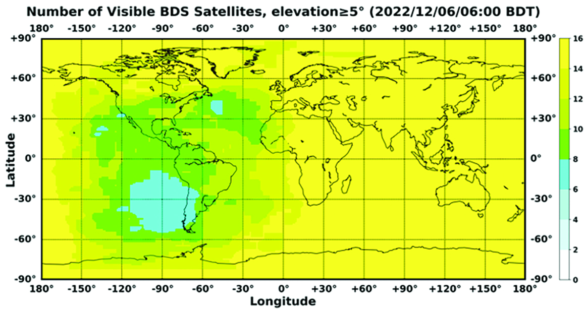
In orbit are 45 BDS operational satellites, including 15 BDS-2 satellites and 30 BDS-3 satellites. Figure 1 shows the number of visible BDS satellites worldwide as of BDT 06:00 on Dec. 6, 2022.
Figure 1. Number of visible BDS satellites. (Image: www.csno-tarc.cn)
BDS has reached a continuity of 99.996% and an availability of 99%. The innovative constellation involves inter-satellite links, signal system optimization, intelligent operation and maintenance, software reconstruction and upgrading of in-orbit satellites, and global test and assessment.
As measured by the International GNSS Monitoring and Assessment System (iGMAS), the BDS global positioning accuracy is less than 1.5 m horizontally and 2.5 m vertically (95% confidence) — better than the nominal service performance parameters.
So far, the measured signal power spectrum envelope of the BDS satellites remains consistent with the superior signal quality; the signal-in-space accuracy of any BDS satellite is better than 4.6 m. The time offset between BDT and UTC (NTSC) remains within 26 ns.
The BDS Coordination Framework has maintained consistency with the International Terrestrial Reference Frame 2014, and the accuracy is better than 3 cm. The orbital accuracy of the broadcast ephemeris of the BDS-3 medium Earth orbit (MEO) satellite is better than 0.5 m, and the clock offset of the broadcast ephemeris of the BDS-3 satellites is better than 5 ns.
BDS concentrates on construction of the application infrastructure and has established four major characteristic service platforms:
Short Message Communication Service
Satellite-based Augmentation System Service
Search-and-Rescue Service
Ground Based Augmentation System Service.
These platforms will expand and upgrade the applications and provide more efficient and convenient services for users.
The BDS Short Message Communication Service platform realizes the interconnection with ground mobile communication systems and networks, and integrates the BDS short message communication functionality into smartphones without the need to change the SIM card or contact number.
For the BDS Satellite-based Augmentation System Service platform, the system’s ground segment includes 30 monitoring stations and two data processing centers. The system will provide single frequency (SF) and dual-frequency multi-constellation (DFMC) services through GEO satellites. The Civil Aviation Administration of China has initiated and organized the technical testing and certification of SF service before applications.
The BDS Search-and-Rescue Service provides users with distress alert information access and distribution, as well as return link services. It is currently at the initial operational stage with sound performances. The operational status of the BDS SAR payload has been submitted to Cospas-Sarsat.
The BDS Ground-Based Augmentation System Service platform’s real-time positioning accuracy can reach 2 cm horizontally and 5 cm vertically. The post-processing accuracy can reach 2 mm horizontally and 5 mm vertically. At present, the BDS ground-based augmentation network has provided the A-BDS positioning and the BDS high-precision services for more than 1.5 billion users in more than 230 countries and regions, with services delivered 2 trillion times in total, equivalent to nearly 3 billion on average per day. BDS has provided high-precision positioning services for more than 20 million mobile phones in the country.
The BDS Applications Industry
The BDS applications industry has achieved sustainable development. In 2021, the total output of China’s satellite navigation and location-based service industry reached about 469 billion yuan (about 67.4 billion U.S. dollars), with a compound annual growth rate of more than 20%. A complete industrial chain covering chips, modules, antennas, boards, terminals and services has been established.
Industrial applications. BDS has been fully applied in various industries — including transportation, agriculture, forestry and fishery, public security, disaster mitigation and relief — and has been integrated into infrastructure such as electric power, water conservation, finance and communications.
As BDS applications fields expand, its in-depth applications have been growing as well. As of June 2022, more than 8 million BDS terminals had been installed in the transportation sector. More than 1.3 million terminals were used in the farming, forestry, livestock and fishing industries, and more than 1.8 million terminals were adopted by public security agencies. Large-scale BDS applications have been advanced in communication and timing services, meteorological monitoring, emergency response and disaster mitigation, and urban management. In emerging applications sectors, BDS has served epidemic prevention and control, telemedicine, caring for seniors, promoting the realization of intelligent health services that serve everyone, and accelerating intelligence and modernization in related fields.
Mass market applications. BDS has been widely used in mass market applications, such as mobile phones and wearable devices. In the first half of 2022, among all types of smartphones that applied for network access in China, 128 supported the BDS-based positioning function. More than 130 million smartphones supporting BDS services were shipped, accounting for more than 98% of the country’s total volume. The BDS positioning service is used more than 100 billion times daily on average for a platform that supports mobile map navigation. In particular, mobile phones have been fitted with high-precision positioning services. Lane-level navigation has been implemented in eight cities in China, including Shenzhen, Chongqing and Tianjin. The first mobile phone in the world that supports BDS-3 regional short message communication services has been officially released, enabling users to send short messages through BDS.
BDS international applications. BDS has been applied in more than half the countries and regions in the world, with more diversified application modes and application fields.
BDS products, technologies and services have been recognized by more international users:
In Mozambique, BDS-based UAVs have greatly improved the efficiency of plant protection operations
In Lebanon, BDS-based high-precision technology has been successfully applied to the construction and measurement of the port of Beirut
In Burkina Faso, BDS supported surveying and mapping during the construction of hospitals to prevent and control local infectious diseases, such as COVID-19
In Saudi Arabia, BDS is widely used in fields such as surveying and the collection of geographic information, the construction of urban and municipal infrastructure, and the positioning of personnel or vehicles in deserts
In Asia, BDS-based high-precision positioning services are contributing to the monitoring of Sarez Lake Dam in Tajikistan, the completion of the China-Kyrgyzstan-Uzbekistan Highway, the China-Kazakhstan crude oil pipeline, and the routine operation of China-Europe Railway Express.
International Cooperation
Following the principles of openness, cooperation and resource sharing, BDS has been actively carrying out practical international cooperation and exchanges as well as facilitating the development of global satellite navigation.
Multilateral cooperation. BDS representatives continue to participate in international activities under the framework of the United Nations International Committee on GNSS and other multilateral forums, to advocate joint development of global satellite navigation by contributing Chinese wisdom and proposals. BDS has also participated in international academic conferences in the field of satellite navigation, such as the Institute of Navigation meetings, the Munich Satellite Navigation Summit, and the Multi-GNSS Asia Conference.
Bilateral cooperation. The Ninth Meeting of the China-Russia Project Committee on Major Strategic Cooperation in Satellite Navigation was successfully held in September 2022. Under the framework of the Committee, BDS and GLONASS have carried out continuous cooperation in such areas as compatibility and interoperability, system performance testing and assessment, and joint applications. China’s Satellite Navigation Office signed cooperation documents in the field of satellite navigation with partners from the United Arab Emirates and the Arab Civil Aviation Organization, to carry out extensive cooperation and continue to deepen cooperation with Pakistan, Iraq, Thailand, Argentina, South Africa and other countries.
International Standards. BDS is increasingly recognized by international organizations such as the International Maritime Organization (IMO), the International Civil Aviation Organization (ICAO), Cospas-Sarsat, IEC, 3GPP and RTCM. In November 2022, the BDS Message Service System (BDMSS) was ratified by the Global Maritime Distress and Safety System (GMDSS), making BDMSS the third GMDSS satellite communication system recognized by the IMO. The Declaration of Intent for Cospas-Sarsat MEOSAR Cooperation was signed between the cooperating agencies (from Canada, France, Russia, and the United States) of the International Cospas-Sarsat Program and the Maritime Safety Administration of China, meaning China formally becomes the provider of the Cospas-Sarsat space segment.
The Future
In the future, BDS will launch back-up satellites to ensure better performance by upgrading the constellation’s availability. While maintaining stable operation, BDS will speed up in combination with new technologies such as 5G, artificial intelligence and Big Data to build a more ubiquitous, more integrated, and more intelligent national comprehensive PNT system by 2035. BDS will continuously adhere to the development concept that “BDS is developed by China, dedicated to the world and aiming to be world class,” promote system development and make contributions to social development and construction of the community with a shared future for mankind.
For analogous updates on the other three GNSS constellations, please see:
ION’s Pacific PNT Conference is a global cooperative development of Positioning, Navigation and Timing technology and applications where policy and technical leaders from around the world meet to discuss policy updates, receive program status updates and exchange technical information.
The 2022 conference will be hosted virtually April 11-13 PDT on a complimentary basis for ION members. The conference will include sessions on policy and status updates, performance schedules and plans, plus special challenges affecting Asia-Pacific presented by an elite list of experts representing BeiDou, COSMIC/ FORMOSAT, and QZSS.
A session will broadcast each day at 9:00 a.m. JST / 5:00 p.m. PDT. Live-stream attendees will have the opportunity to participate in virtual question and answer periods through the portal.
SBG Systems has opened a new subsidiary in Singapore. Located in the center of the city, this new office brings sales and technical support to the Asian region.
SBG Systems is a leading supplier of MEMS-based inertial measurement units (IMU) and inertial navigation systems (INS) for land, air and marine applications. The company has been developing its sales distribution channels in Asia for many years and has decided to bring sales and technical support closer to its clients and distributors by establishing a subsidiary in Singapore.
“We wanted to get closer to our customers and distributors in the region,” said Thibault Bonnevie, SBG Systems’ CEO. “By getting geographically closer, we wish to build closer relations with our esteemed customers and distributors and provide them with the highest quality service they deserve.”
The Singapore office will provide support to new and existing clients in the region with demonstrations, training and technical support.
The Broadcom BCM47531 GNSS chip generates positioning data from five satellite constellations simultaneously, including BeiDou.
Broadcom Corporation has introduced the BCM47531, a GNSS chip that generates positioning data from five satellite constellations simultaneously — GPS, GLONASS, QZSS, SBAS and BeiDou. The newly added BeiDou constellation increases the number of satellites available to a smartphone, enhancing navigation accuracy, particularly in urban settings where buildings and obstructions can affect performance.
More than 226 million mobile phones were sold to end users in Asia in the first quarter of 2013, increasing the region’s share of global mobile phones to 53.1 percent, according to Gartner (“Market Share Analysis: Mobile Phones, Worldwide,” 1Q13). As smartphone adoption continues to accelerate, users continue to identify location and mapping as a top requirement. Broadcom’s new GNSS system-on-chip (SoC) is based on its widely deployed architecture that reduces the time to first fix and allows smartphones to quickly establish location and rapidly deliver mapping data. The SoC also features a tri-band tuner that enables smartphones to receive signals from all major navigation bands (GPS, GLONASS, QZSS, SBAS, and BeiDou) simultaneously. By allowing use of any combination of satellites, users experience more accurate and consistent location performance in Asia and throughout the world.
“Broadcom’s new GNSS chip with BeiDou support provides OEMs with a cost-effective, low-power solution to deliver enhanced positioning capabilities for challenging city environments,” said Charles Abraham, Broadcom vice president & general manager, GPS. “Drawing on Broadcom’s long history of GNSS innovation, our new platform improves the navigation experience of smartphone users in most regions of the world and unlocks new location-aware applications.”
The BCM47531 platform is available with Broadcom’s location-based services (LBS) technology that delivers satellite assistance data to the device and provides an initial fix time within seconds, instead of the minutes that may be required to receive orbit data from the satellites themselves.
Key Features and Benefits:
Simultaneous support of five constellations (GPS, GLONASS, QZSS,SBAS and BeiDou) allows for position calculations based on measurements from any of 88 satellites.
Broadcom’s tri-band tuner brings the ability to receive all navigation bands, GPS (which includes QZSS and SBAS), GLONASS and BeiDou simultaneously to the commercial GNSS market without having to reconfigure and hop between bands.
Utilizes BeiDou signals for up to 2x improved positioning accuracy.
Best-in-class Assisted GNSS (AGNSS) data available worldwide from Broadcom’s hosted reference network.
Allows a device to interchangeably use the best signal from any satellite regardless of the constellation, ensuring better accuracy in urban and mountainous environments.
Features advanced digital signal processing for interference rejection that enables satellite signal search and tracking during LTE transmission.
Leverages Broadcom’s connectivity solutions including Wi-Fi, Bluetooth
Smart, Near Field Communications (NFC), Instant Messaging System (IMES) and handset inertial sensor data for best indoor/outdoor location.
By Chris Rizos, Co-chair, Steering Committee of Multi-GNSS Asia
A dramatic increase over the next five years to roughly 100 GNSS satellites in the skies over Asia and Oceania makes that region the fastest growing area in GNSS. The Multi-GNSS Asia (MGA) initiative, a cooperative international demonstration campaign, seeks to take full advantage of this scientific and technical windfall, gaining early experience with the new signals and services of multi-constellation GNSS.
The MGA organization is sponsored by Japan’s Aerospace Exploration Agency (JAXA), and seeks to promote the region as the “showcase of the new GNSS era” through this demonstration campaign. See an animation of the burgeoning satellite availability over the coming decade. The MGA demonstration campaign consists of a series of activities from 2010 to 2015.
Infrastructure Deployment. JAXA is currently deploying a multi-GNSS monitoring (MGM) network, consisting of continuously operating reference stations equipped with multi-GNSS receivers, that will support the production of precise orbit and satellite clock offset information for the multiple constellations. The MGM-net will be deployed in two stages. The first 20 receivers supplied by JAXA will go to hosting countries and organizations in the Asia-Oceania region by early 2012, with an additional 40 available for deployment globally in 2013. The MGM-net is a component of the tracking network of the International GNSS Service (IGS) global multi-GNSS experiment (M-GEX, igs.org). Both MGM-net and M-GEX will include data and analysis centers and faciltate the sharing of information and resources among participating organizations. The multi-GNSS tracking data will be available to everyone in the form of RINEX files.
Projects. Joint experiments involving new or extended multi-GNSS applications, such as disaster management, intelligent transportation systems, precise positioning, and location-based services will be promoted among GNSS providers, receiver manufacturers, local service providers, government organizations, and universities in the Asia-Oceania region. Some of these will take advantage of the special characteristics of the first QZSS satellite, Michibiki. Several project proposals have been submitted over the last year; one of particular interest is a call by JAXA for a “Multi-GNSS Joint Experiment.” Such experiments could include using the broadcast augmentation message known as the L-band Experimental (LEX) signal, modulated on the L6/E6 frequency at 1278.75MHz, to support precise positioning. China has recently proposed a “BeiDou Application Demonstration & Experience Campaign” (BADEC) as an MGA project activity.
Regional Workshops. An important MGA activity is the organization of an annual workshop to report on joint experiments and results and to promote new joint projects. The First Asia Oceania Regional Workshop on GNSS (AORWG), held in January 2010 in Bangkok, Thailand, drew 195 participants from 18 countries.
The second AORWG took place that November in Melbourne, Australia, and drew 101 participants from 11 countries.
The most recent AORWG was held November 1–3 this year on Jeju Island, South Korea, attracting 86 participants. Five demonstration projects were proposed by researchers from Japan, South Korea, Taiwan, Australia, and Malaysia, and were all endorsed by the MGA Steering Committee.
They are:
Evaluation of Multi-GNSS for Precision Agriculture in Korea; Chungnam National University, Korea
Sustainable Resource Utilization by Precision Farming of Oil Palm Plantation; RTK-Auto Guided Oil Palm Planter; On-the-Go Soil ECa Mapping; University Putra Malaysia , Malaysia
Automated rice transplanter guided by using Multi-GNSS including QZSS; Agricultural Research Center, National Agriculture Research Organization , JAPAN
Joint QZSS/GPS positioning using L1/L5 band signals; National Cheng Kung University, Taiwan
Multi-GNSS Experiment; Royal Melbourne Institute of Technology University, Australia.
The status of the MGM-net deployment and the results of the demonstration projects will be presented at the fourth AORWG scheduled for November 2012 in Kuala Lumpur, Malaysia.
China’s BADEC. At the third AORGW, Dr. X. R. Dong, an expert from the International Cooperation Research Center of China Satellite Navigation Office (CSNO), introduced plans for several long-term project activities under the banner of the BeiDou/GNSS Application Demonstration & Experience Campaign (BADEC). This is another important proposal from China, following the International GNSS Monitoring and Assessment Service (iGMAS) that has drawn attention and support from GNSS providers, users, and international organizations.
A subgroup dealing with iGMAS is approved and setup by ICG-6; the sub-group is co-chaired by Dr. X. R. Dong, IGS and Satoshi Kogure from Japan. Besides continuing to advocate for iGMAS, the goals of BADEC include seeking to make the Asia-Oceania region a showcase of the new GNSS era, and including BeiDou-specific goals such as “welcome the introduction and utilization of BeiDou services,” “let users experience the Multi-GNSS including BeiDou,” and “encourage GNSS provider and users to carry out experiment and demonstration jointly.”
Both IGMAS and BADEC will contribute to promote the GNSS open-service performance, compatibility, and interoperability, to be implemented through extensive international cooperation, especially with the IGS’s M-GEX and MGM-net.
Chris Rizos is professor and head of the School of Surveying & Spatial Information Systems, University of New South Wales, Sydney, Australia. He is president of the International Association of Geodesy, serving from now into 2015.