Tag: Atlas Correction Services

  • Juniper Systems launches next-gen Geode GNS3 GNSS receiver

    Juniper Systems launches next-gen Geode GNS3 GNSS receiver

    Photo: Juniper Systems
    Photo: Juniper Systems

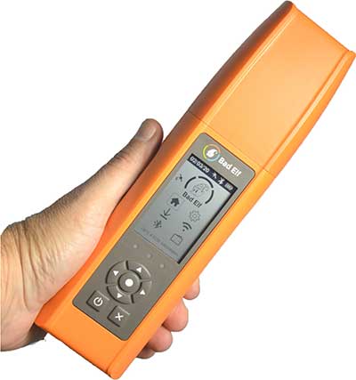
    Juniper Systems has introduced the Geode GNS3 GNSS receiver, which allows users to collect real-time GNSS data with sub-meter, sub-foot and decimeter accuracy options.

    With a scalable platform, users can purchase the level of accuracy they need now, while having the option to increase accuracy in the future.

    “This new Geode offers expanded accuracy options to our users,” said John Florio, Geode product manager at Juniper Systems. “We set out to deliver a product that is scalable to our user’s needs. The GNS3 allows users to purchase a receiver that fits their accuracy needs at the moment, while still being able to unlock greater accuracy through subscriptions when that need arises.”

    Photo: Juniper Systems
    Photo: Juniper Systems

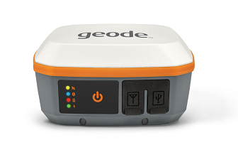
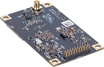
    Available in both single-frequency and upgradable multi-frequency antenna configurations, users have the level of accuracy needed to get the job done. The Geode GNS3S offers superb sub-meter accuracy with a single-frequency antenna. The GNS3M allows for scalable accuracy; its multi-frequency antenna support all constellations on L1, L2 and L5 frequencies.

    Multi-frequency signal tracking, together with Atlas L-band correction subscriptions, allow for up to decimeter accuracy. As with previous Geode devices, SBAS corrections are available for sub-meter accuracy in certain regions.

    Both models also support local differential GNSS real-time kinematic (RTK) and continuously operating reference networks (CORS) through the Geode Connect NTRIP client.

    “Providing Atlas corrections and scalable accuracy allows for the Geode to be used in new markets,” Florio said. “A few of these include water utility locating, agriculture and irrigation mapping, mapping projects in remote locations where other correction services are not available, and any other mapping need that requires a higher degree of accuracy.”

    The Geode GNS3 offers flexible connectivity and can be used with Windows, Android, iPhone and iPad devices. A USB-C port allows for data transfer and fast charging and an antenna port allows for the use of an external antenna.

    The Geode GNS3 GNSS receiver is now available worldwide.

  • Bad Elf GNSS receiver adopts Hemisphere Phantom module

    Bad Elf GNSS receiver adopts Hemisphere Phantom module

    Bad Elf LLC has completed transition of all Bad Elf Flex receivers to the Hemisphere GNSS Phantom OEM module.

    Photo: Bad Elf
    Photo: Bad Elf

    As one of the first partners to incorporate the Phantom, Bad Elf Flex offers significantly enhanced capabilities and further exemplifies the company’s commitment to future-ready GNSS designs.

    “We tested the Phantom OEM modules extensively, and confirmed they deliver the promised power savings and performance improvements when integrated with the Bad Elf Flex,” said Larry Fox, Bad Elf’s vice president of marketing and business development. “Hemisphere’s technology allows us to democratize GNSS through Bad Elf Flex.”

    The new Phantom modules deliver a 30% gain in battery life, superior performance and scalable access to every GNSS constellation and signal, including GPS, Galileo, GLONASS, BeiDou, QZSS, IRNSS, SBAS and Hemisphere’s Atlas L-band, Fox said.

    Photo: Hemisphere GNSS
    Photo: Hemisphere GNSS

    Bad Elf Flex is a scalable-accuracy GNSS receiver with a daily option to choose between L-band and real-time kinematic (RTK). In standard configuration, it achieves 30-60 cm accuracy in real-time for GIS use.

    Consuming a Bad Elf Flex Token unlocks a full RTK workflow for a 24-hour period to deliver 1-cm horizontal accuracy. Bad Elf Flex stores the tokens directly on the receiver, making them available for use anytime and anywhere. Customers requiring high accuracy at all times can purchase the Bad Elf Flex Extreme bundle, with RTK capabilities permanently unlocked, for a one-time upgrade fee.

    Surveyors and their crews now have a scalable-accuracy, survey-grade receiver. GIS managers can focus on flexible field choices for work crews with varying skill levels. Bad Elf Flex falls within most capital expense budgets, allowing businesses to obtain operational and financial efficiencies.

    “Bad Elf saw an opportunity to offer the GIS community a product lineup with better than 3-meter accuracy for under $3,000,” said John Cunningham, Bad Elf’s chief executive officer. “We began three years ago with our 2-meter ($300) and 1-meter ($600) mapping-grade product offerings. Our customers continued asking us to address the 50 cm, 10 cm and 1 cm requirements for their businesses. We worked hard over the past two years to build a platform, Bad Elf Flex ($3,000), that addresses these needs without breaking budgets. We have a solution that works today and provides a foundation to meet future customer requests. We love learning from our customers and look forward to continuing this conversation and extending high-accuracy GNSS for all.”

    “Hemisphere is excited that Bad Elf’s Flex series now features our latest generation GNSS receiver,” said Miles Ware, director of marketing at Hemisphere. “We believe the scalable accuracy option made possible by our high-performance Atlas L-band correction service will be a game-changer in their served markets.”

  • EOS Positioning Systems helps Haiti achieve clean drinking water

    EOS Positioning Systems helps Haiti achieve clean drinking water

    Haiti Outreach is on a mission to bring clean drinking water to 100% of Haitian communes. The non-profit organization is using EOS Positioning Systems’ Arrow Gold GNSS receivers to transform how water access is addressed.

    In the Western Hemisphere’s poorest nation, poverty and corruption have stifled development. But Haiti Outreach is using geospatial software and donations to ensure every household has access to clean drinking water. Their technology includes mWater, EPANET, and Arrow Gold with Atlas.

    In this video, you’ll hear from Haiti Outreach Director Neil Van Dine and Eos Positioning Systems CTO Jean-Yves Lauture on the importance of combining spatial strategy with a human element.

    In Haiti 95% of unprotected springs are contaminated with E. coli, with 48% of water infrastructure across 50 communes delivering water contaminated with E.coli (Haiti Outreach 2018 study). For 22 years, a nonprofit called Haiti Outreach has tried to increase access to clean water by drilling wells for Haitian communities (called communes).

    Haiti Outreach tried drilling new wells, but that didn’t solve the problem. The answer is education. “It’s all about creating a transformation in the way we think,” Van Dine said. “Water is free, but somebody has to maintain the well, replace parts, and so on in the long term. All those things cost money.”

    Achieving a 50-cents per household fee for maintenance, Haiti Outreach still needed to know if everyone in Haiti had access to clean drinking water. The organization needed to know the location of every household in relation to water sources. They also needed to know if these water sources were clean, contaminated, functioning or broken.

    Outreach decided to use the open-source hydraulic-modeling software EPANET, from the U.S. government, and hired mWater to build an integration. By running population-density overlays in mWater, it was possible to identify where there were enough households (25) to create a revenue stream to support a new well. With 100 households, the revenue could support a new in-home water-distribution network.

    Photo: Haiti Outreach
    Photo: Haiti Outreach

    They also used Android phones and Arrow Gold with Atlas. By pairing the Arrow Gold with Atlas, they were able to get decimeter accuracy. (Atlas is a satellite-based differential correction service.)

    “The Android phones got about 10 meters of accuracy on their own,” Haiti Outreach fieldwork coordinator Micki Johns said. “But the Arrow Gold with Atlas got us within that decimeter range.”

    Data collected in mWater went into EPANET to simulate water pressure and flow.

    Haiti Outreach used the findings to develop a community action plan (CAP). The CAP prioritized cleaning contaminated sources and ranked contaminated sources by the highest number of people who would benefit from a decontamination.

    Learn more about the program here.

  • Hemisphere GNSS releases Atlas-capable Vector V200 GNSS compass

    Hemisphere GNSS releases Atlas-capable Vector V200 GNSS compass

    Photo: Hemisphere GNSS
    Photo: Hemisphere GNSS

    Hemisphere GNSS has launched a single-frequency, multi-GNSS Vector V200 smart antenna with integrated Atlas L-band designed for general marine applications and markets.

    The V200 is being featured in the Hemisphere/Saderet stand (K12) at Ocean Business 2019 in Southampton, UK, from April 9 through 11.

    Powered by Hemisphere’s Crescent Vector technology, the V200 is a multi-GNSS compass system that utilizes GPS, GLONASS, BeiDou, Galileo, and QZSS (with future firmware upgrade and activation) for simultaneous satellite tracking to offer heading, position, heave, pitch and roll output.

    With support for NMEA 0183 and NMEA 2000, integrating Atlas L-band corrections, and continuing to offer ease of installation, the V200 packages and offers exceptional value and performance. The V200 excels in providing accurate position and heading information to autopilots, chart plotters and other general marine navigation applications.

    The all-in-one V200 GNSS compass combines Hemisphere’s Crescent Vector H220 OEM board, two superior multipath and noise-rejecting antennas (spaced 20 cm apart), a multi-axis gyro, and tilt sensors in a single easy-to-install and use enclosure.

    The V200 delivers 1.5 degree (or optional 0.75 degree) heading accuracy and Atlas L-band accuracies of 30 cm to 60 cm and offers instantaneous sub-meter accuracy and DGPS-level accuracy.

    Measuring only 35 cm in length, the V200 can be either pole or surface mounted and comes in either 5- or 12-pin options that require only a single power/data cable connection for fast and reliable installations, even in the presence of strong radio transmissions.

    “The Vector V200 GNSS compass represents significant enhancements to our industry-leading models it replaces, providing even greater performance, improved robustness, and excellent value,” said Miles Ware, director of marketing at Hemisphere. “Users now have an even higher performing all-in-one Vector for their marine applications with the addition of BeiDou, Galileo and QZSS, as well as Atlas L-band corrections.”

  • Hemisphere GNSS launches Vector V500 GNSS compass smart antenna

    Hemisphere GNSS launches Vector V500 GNSS compass smart antenna

    Hemisphere GNSS has released its RTK-enabled Vector V500 smart antenna. The company made the announcement at the Oceanology International conference being held this week in London, U.K.

    The V500 supports multi-frequency GPS, GLONASS, BeiDou, Galileo, QZSS and IRNSS (with future firmware upgrade and activation) for simultaneous satellite tracking. The V500 is powered by Hemisphere’s Athena RTK (real-time kinematic) engine and is Atlas L-band capable.

    Using Hemisphere’s Eclipse Vector technology, the all-in-one V500 is a complete compass system that offers GNSS-based heading, pitch, roll, heave and RTK positioning, the company said.

    The V500 introduces support for Ethernet, Bluetooth and Wi-Fi in addition to NMEA 0183 and NMEA 2000 and offers unmatched ease of installation.

    Purpose-built for challenging applications, the V500’s rugged enclosure works reliably in harsh environments and is designed for professional marine applications requiring high-precision heading combined with RTK or Atlas positioning.

    The V500 is Hemisphere’s flagship rugged smart antenna. It combines the recently announced Eclipse Vector H328 OEM board with two superior multipath- and noise-rejecting antennas (spaced 50 cm apart) in a single enclosure.

    The V500 requires a single power/data cable connection, allowing for fast and reliable installations even in the presence of strong radio transmissions.

    According to Hemisphere GNSS, the V500 delivers 0.17 degree heading accuracy along with RTK positioning and Atlas L-band accuracies of up to 8 cm (95 percent).

    “The Vector V500 combines our expertise in GNSS, smart antenna design, and our new technology features such as Atlas,” said Lyle Geck, senior product manager at Hemisphere GNSS. “With very competitive RTK performance and the simplicity of installation offered by the all-in-one smart antenna design, it is an incredible product.”

    Atlas GNSS Global Correction Service. Atlas is a flexible and scalable GNSS-based global L-band correction service providing robust performance and correction data for GPS, GLONASS and BeiDou, the company said. Atlas delivers correction signals via L-band satellites to provide accuracies ranging from sub-meter to sub-decimeter levels, and leverages approximately 200 reference stations worldwide, providing coverage to virtually the entire globe.

    Atlas is available on all Hemisphere Atlas-capable single- and multi-frequency, multi-GNSS hardware and complements third-party GNSS receivers by using Atlas corrections with Hemisphere’s SmartLink and BaseLink capabilities. Atlas creates fast convergence times, and is robust and reliable near wharfs, piers, offshore rigs, cranes and other overhead obstructions.

    Atlas Basic provides users of both single- and multi-frequency Atlas-capable hardware the ability to achieve better than SBAS performance anywhere Atlas correction service is available. Atlas Basic offers accuracy of 30 cm (pass-to-pass 95%) to 50 cm (absolute 95%) and offers instantaneous sub-meter accuracy.

    The Vector V500 is featured in the Hemisphere GNSS booth (G500) at the Oceanology International exhibition and conference in London, UK, March 13-15. The new V500 will be available soon through Hemisphere’s global dealer network.

  • Hemisphere GNSS enhances Atlas correction service

    Hemisphere GNSS released a series of major enhancements to its Atlas GNSS Global Correction Service, including Atlas Basic, Atlas AutoSeed and the addition of global ionospheric modeling to the system.

    The company made the announcement at Agritechnica 2017, Nov. 12-18 in Hanover, Germany, where it exhibited in hall 15, booth E10.

    Atlas is a flexible and scalable GNSS-based global L-band correction service, providing robust performance and correction data for GPS, GLONASS and BeiDou, the company said. Delivering its correction signals via L-band satellites at accuracies ranging from meter to sub-decimeter levels, Atlas also leverages 200 reference stations worldwide, providing coverage to virtually the entire globe.

    Atlas Basic. Hemisphere is now offering Atlas Basic. Atlas Basic provides users of both single- and multi-frequency Atlas-capable hardware the ability to achieve SBAS-equivalent performance anywhere in the world where the Atlas correction service is available.

    Atlas Basic offers accuracy of 30 to 50 centimeters (cm): 30 cm is pass-to-pass 95 percent based on 15-minutes convergence time, and 50 cm is absolute 95 percent. Atlas Basic also offers instantaneous sub-meter accuracy, allowing for Differential GPS (DGPS) level accuracy.

    Hemisphere is offering Atlas Basic as an activation on all Atlas-capable single- and multi-frequency Hemisphere products purchased before Feb. 1, 2018. Correction service users will no longer need subscriptions for Atlas Basic service levels at 50-cm (95 percent) accuracies.

    “Having the ability to easily scale your correction service levels based on specific use cases is essential to our customers and OEM partners,” said Miles Ware, director of marketing at Hemisphere GNSS. “With the addition of Atlas Basic, we are making it easier for anyone with an Atlas-capable single- or multi-frequency, multi-GNSS receiver to achieve sub-meter, SBAS-equivalent positioning accuracy virtually anywhere on earth.”

    Global ionospheric modeling. Also included in the enhanced Atlas system is the addition of global ionospheric modeling. Using real-time ionospheric data, Atlas adjusts its corrections accordingly, providing instantaneous convergence for sub-meter accuracy.

    AutoSeed. Atlas’ new AutoSeed technology allows users to suspend Atlas use for any period, and upon returning to their last location, AutoSeed rapidly re-converges to a high-accuracy converged position.

    * Based on 15-minutes convergence time. Also depends on multipath environment, number of satellites in view, satellite geometry and ionospheric activity.

    Atlas is available on all Hemisphere Atlas-capable single- and multi-frequency, multi-GNSS hardware and complements third-party GNSS receivers by allowing them to use Atlas corrections with Hemisphere’s SmartLink and BaseLink capabilities.

    When using multi-frequency hardware, Atlas corrects more satellites than ever before, to create faster convergence times, and is robust and reliable in canopy or foliage covered areas.

    With both single- and multi-frequency hardware, Atlas achieves instant global sub-meter positioning accuracy, comparable to and typically more robust than SBAS, since Atlas corrections contain data from multiple available constellations, the company said.

  • Carlson offers Atlas GNSS Correction Service through SurvCE

    Carlson Software is now offering Atlas GNSS global correction service in the latest release of its data-collection software SurvCE.

    Using approximately 200 reference stations worldwide, Atlas produces its correction signals via L-Band satellites distributing coverage from 75° N to 75° S, ensuring Earth’s landmass is covered. Such ability makes it the most flexible service on the market to date, Carlson Software said.

    “Atlas equals or excels beyond the performance standards of other services and interfaces seamlessly with Carlson SurvCE to boot,” said Karl Nicholas, special projects director at Carlson Software.

    Atlas supports multiple RTK-capable GNSS receivers including the current Carlson BRx6. Through Carlson SurvCE’s library of compatible drivers, any third-party GNSS receiver using the Athena engine can also use Atlas.

    Capabilities

    • Positioning Accuracy: Atlas provides positioning accuracies down to 2 cm RMS in certain applications
    • Positioning Sustainability: Cutting-edge position quality maintenance in the absence of correction signals
    • Convergence Time: Industry-leading convergence times of 10 – 40 minutes

    Scalable Service Levels

    • H100: 100 cm 95 percent (50 cm RMS)
    • H30: 30 cm 95 percent (15 cm RMS)
    • H10: 8 cm 95 percent (4 cm RMS)

    Subscriptions to Atlas can be added to the Carlson BRx6 or other supported GNSS receiver when using SurvCE version 5.06 or later through a certified Carlson dealer or at carlsonsw.com/atlas.

  • VADER + Atlas help troubleshoot on the job

    Hemisphere’s Atlas-enabled Platinum VADER smart antenna.

    Plantium, in Santa Fe, Argentina, is a full-service provider of precision agricultural guidance systems to some of Argentina’s largest farming operations.

    The company makes its own guidance and control devices, installs them and offers farmers real-time, remote support if required. Plantium uses the Atlas GNSS Global Correction Service as the primary means of providing precise, real-time location corrections to its customers, and their receivers are based on Atlas-ready OEM boards from Hemisphere GNSS.

    “We design, manufacture and sell precision agriculture systems,” said Federico Baulies, robotics engineer for Platinum. “As a part of our SBOX7 + DirectDrive + VADER system, Atlas really helps with all of these. Atlas tools give us the ability to diagnose and solve problems in real-time — probably its best feature.”

    “As soon as we hear of an issue, from operators or from alarms built into our monitors, we can collect several working variables — such as interference and satellite noise — immediately, from our offices, and diagnose many problems instantly,” Baulies explained.

    Argentine farmers benefit from remote problem-solving with the Hemisphere Atlas-enabled Platinum VADER smart antenna.

    “That means we do not have to wait for 30 minutes to see if our client will get convergence — we know right away. A lot of that capacity is built right into the Hemisphere OEM boards or from the way the Atlas service is designed.

    “These diagnostic tools also help on the customer’s end,” Baulies said. “The Atlas service and Hemisphere’s OEM boards make clear user interfaces possible, and end users are rarely confused about the state of their equipment.”

    Once a problem is diagnosed, Plantium engineers can implement fixes quickly, using cellular connectivity.

    “We can often diagnose and fix a problem remotely, sometimes in the same phone call,” Baulies said.

  • SXblue introduces Platinum survey-grade GNSS receiver

    SXblue introduces Platinum survey-grade GNSS receiver

    Geneq has introduced the SXblue Platinum, the latest model in the SXblue series. This high-accuracy GNSS receiver is compatible with iOS, Windows and Android Bluetooth, and provides real-time professional-grade positioning information.

    Powered by 394 channels, the SXblue Platinum uses all constellations (GPS, GLONASS, Galileo, BeiDou and QZSS) with triple frequency, and provides the ability to use global or local coverage for corrections (SBAS, L-band and RTK).

    With the scalable SXblue Platinum Basic, users can activate any frequency or constellation at anytime following initial purchase. The receiver is also field-upgradable, which means that these options can be remotely activated when convenient.

    The Platinum was developed on the success of the proven SXblue receivers that were designed to optimize SBAS performances under tree canopy and in rugged terrain. In addition to location performances when working in a restricted environment, the SXblue Platinum is introducing an L-band signal correction via the Atlas service. This worldwide satellite-based correction system can deliver up to sub-decimeter accuracy. Thanks to its new Tracer technology, the receiver can sustain its level of accuracy when the Atlas signal is interrupted. The Atlas service can also stream data over the internet (NTRIP) while ensuring the best available vertical and horizontal accuracy.

    Another innovative feature integrated on the Platinum model is the aRTK technology. This feature will allow RTK corrections to be received via the Atlas service, when RTK corrections have not been received for a period of time. For an Atlas-subscribed user device, a high accuracy will still be available at the subscribed service level until RTK is restored.

    The new receiver is the same compact, lightweight, palm-sized unit as the SXblue series, which is completely dustproof and ruggedized. The internal, rechargeable, field-replaceable Li-Ion battery has on-board LEDs for easy access to battery life information.

    The SXblue Platinum is targeted at GPS/GIS mapping and survey professionals in industries such as forestry, utilities, agriculture, environmental and other natural resource industries in addition to local, state and federal government users.

    With a wide variety of compatible software and mobile devices, the support team can help users choose the perfect solution for their applications. A free iOS application for NTRIP/DIP configuration, named iSXblue RTN, is available from the App Store.

  • Hemisphere GNSS debuts smart antenna for survey

    Hemisphere GNSS debuts smart antenna for survey

    Hemisphere GNSS has released the S321, its next-generation multi-frequency, multi-GNSS survey smart antenna. The S321 — designed for land or marine survey — combines Hemisphere’s Athena and Atlas technologies with a new web user interface offering customer-friendly performance.

    For professional marine applications — such as  marine construction, hydrographic surveying or dredging — using the S321 with Athena RTK (real-time kinematic) enables users to achieve impeccable results and maintain peak up-time, the company said. The ruggedized antenna was designed for demanding and challenging environments and meets IP67 requirements.

    The S321 smart antenna by Hemisphere GNSS.
    The S321 smart antenna by Hemisphere GNSS.

    “The S321 is another example of how much Hemisphere has changed,” said Chuck Joseph, president and CEO. “A fantastic survey smart antenna with industry-leading RTK, connectivity, and management capabilities, the S321 offers unbeatable performance and value to the industry.”

    Athena RTK

    Athena excels in environments where high-accuracy GNSS receivers can be used. Hemisphere’s customers have tested and proven Athena’s performance in long baseline, in open-sky environments, under heavy canopy, and in locations experiencing significant scintillation.

    • Initialization time – Reliably consistent initialization performance, while at the same time performing initializations in less than 15 seconds at better than 99.9 percent reliability.
    • Robustness in difficult operating environments – Extremely high productivity under aggressive geographic and landscape-oriented environments for GNSS.
    • Performance on long baselines – Position stability for long baseline applications.
    • Performance under scintillation – Sustained accuracy under ionospheric scintillation activities.

    Atlas GNSS Global Corrections

    The S321 ships preconfigured to test drive corrections from Hemisphere’s Atlas global corrections service. The bundled solution provides users worldwide with an easy way to use Atlas, including the worldwide H10 service offering 8-centimeter, 95-percent accuracy (4 cm RMS).

    Network RTK Augmentation

    BaseLink technology allows Atlas-capable receivers like the S321 to self-calibrate, self-survey, and automatically manage the transmission of RTK correction data to augment or extend established or new GNSS reference networks in areas of poor Internet connectivity.

    The S321 introduces Hemisphere’s aRTK technology. Powered by Atlas, aRTK enables the S321 to operate with RTK accuracies when RTK corrections fail. If the S321 is Atlas-subscribed, it will continue to operate at the subscribed service level until RTK is restored.

    The S321 also introduces SureFix, Hemisphere’s new processor running in combination with Athena to provide high-fidelity RTK quality information that results in guaranteed precision with virtually 100 percent reliability.

    Features:

    • Athena RTK engine
    • GPS, GLONASS, BeiDou, Galileo, QZSS
    • 372 channels
    • Atlas corrections delivered via L-band and over the Internet
    • Wireless connectivity via Bluetooth and Wi-Fi
    • Powerful web user interface
    • Two versions (Each can be configured as Base or Rover):
      • UHF + GSM / WCDMA
      • GSM / WCDMA (Network Rover)
    • 4 GB internal memory card and 64 GB-capable MicroSD card for data logging, download and upload.

    The S321 can be ordered now and is available to ship before the end of the month.

    The S321 is making its tradeshow debut at Oceanology International 2016 at ExCeL, London, UK, March 15-17, at booth G500.

    For more information about the S321, Athena, Atlas, or its other advanced features, please call +1 (844) 217-2845 (within Canada / USA only) or +1 (480) 291-6766, or email [email protected].

  • INTERGEO 2015: Hemisphere Discusses Atlas Global Correction Services

    Rodrigo Leandro of Hemsphere GNSS talks about the company’s new Atlas correction service while at INTERGEO 2015, which was held Sept. 15-17 in Stuttgart, Germany.

    Atlas Global Correction Services’ signals via L-Band satellites or over the Internet at accuracies ranging from meter to sub-decimeter levels.