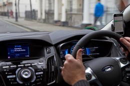
Audi of America, the Virginia Department of Transportation (VDOT) and Qualcomm Technologies Inc. are planning for initial deployments of cellular vehicle-to-everything (C-V2X) communication on northern Virginia roadways.
C-V2X employs advanced wireless communications to enhance vehicle safety by using the same portion of the 5.9-GHz band that the Federal Communications Commission (FCC) has proposed to allocate for C-V2X.
In line with the Federal Department of Transportation’s announcement to establish a First Responder Safety Pilot Program, the organizations’ combined efforts are designed to focus on improving safety for construction workers and motorists.
The initial deployment is expected to take place on select roadways in Virginia beginning in the third quarter of this year.
C-V2X will be used to deliver work zone warnings on highways as well as signal timing information on approaches to signalized intersections on arterial roadways. In both cases, C-V2X communications can help deliver critical safety messages between vehicles and infrastructure with minimal latency, while less time-sensitive alerts are designed to be provided via C-V2X using the cellular network.
Photo: Audi
The initial deployments are aimed at expanding safety use cases in the connected vehicle safety spectrum established by the FCC, with the aim to curtail road hazards and fatalities. In a given year, traffic fatalities in the U.S. exceed 36,000 people.
The initial deployment is designed for connected-car systems designed to
boost safety around school buses,
warn motorists about dangerous road conditions,
alleviate congestion at traffic chokepoints and curbsides,
help improve the performance of automated vehicles that are nearing commercialization
The northern Virginia initial deployment involves two primary use cases:
Work zone warnings, which the organizations feel is an important use case on highways, featuring a Qualcomm 9150 C-V2X chipset solution via an in-vehicle display in Audi Q8 SUVs designed to deliver a graduated warning, with the last link being a low-latency, reliable warning to drivers of the workers’ physical presence.
On arterial roadways, the signal phase and timing (SpaT) from a traffic signal, will be transmitted with a Qualcomm 9150 C-V2X chipset solution to Audi Q8 SUVs. These vehicles have the Audi Traffic Light Information (TLI) service that can provide drivers a countdown to the green light. C-V2X from the traffic signal can also provide direct information to the Audi Q8, which will be used by the TLI system to fine-tune the countdown information of the signal phase and timing.
“VDOT has long supported research into the benefits of connected and automated vehicles, particularly those aspects that have the potential to significantly enhance safety,” said Virginia’s Director of Transportation Research and Innovation Cathy McGhee. “The inclusion of shorter-range, direct communication in the 5.9 GHz band using C-V2X is exciting, as it can allow us to evaluate this emerging communication option for essential and practical safety and mobility services, including saving the lives of maintenance and construction personnel in work zones.”
Photo: Audi
“We recognize the immediate value of the spectrum that the FCC proposed to allocate to C-V2X, and we endeavor to show our V2X equipped cars on real roads engaging in how transportation safety and mobility could be jump-started,” said Anupam Malhotra, Director, Connected Vehicle Services, Audi of America. “We are excited about our participation in this pilot deployment as it highlights the broad societal advantages that technology is now poised to deliver through the full 5.9 GHz V2X spectrum near term with far, far more to come as connected and automated vehicle fleets emerge over the next decade.”
Audi’s Traffic Light Information V2X services operate in 25 cities and nearly 10,000 intersections nationwide, including more than 1,700 intersections in the Washington D.C. metropolitan region.
“Qualcomm Technologies is excited to work with the VDOT, through its partner Virginia Tech and Audi to support the C-V2X use cases on the very same spectrum that the FCC has proposed to allocate for C-V2X. Qualcomm Technologies has long been a pioneer in the connected car with over 20 years of experience delivering in-vehicle telematic systems,” said Jim Misener, senior director, product management, Qualcomm Technologies, Inc. “With the advances in cellular communications now enabling us to also offer direct connectivity for safety services, traffic efficiency and emerging automated use cases, we are pleased to work closely with VDOT, Audi of America and Virginia Tech to showcase the commercial maturity and technological sophistication of C-V2X and to start the proliferation of the technology on U.S. roadways.”
The Virginia Tech Transportation Institute (VTTI) will develop the software and systems to support the primary use cases defined for the initial deployment. Following software development, the institute will then conduct a demonstration of C-V2X technology operating in these use cases.
C-V2X Features and Benefits
The C-V2X solution used in this initial deployment is based on third-generation partnership project (3GPP) Release 14 and Release 15 specifications. Direct communication of this solution uses 20 MHz from the 5.905 – 5.925 GHz ITS band, the same spectrum that the FCC has proposed allocating for C-V2X.
A more advanced mode of C-V2X has an evolution path to 5G using 3GPP Release 16 specifications.
Field test results issued by the 5G Automotive Association (5GAA) have proven C-V2X to be an efficient and effective radio access technology, showing that it significantly increases in range and reliability compared to other radio technologies.
C-V2X commercial products are now widely available in the form of multiple chip platforms, wireless modules, vehicular Onboard Units and infrastructure Roadside Units.
C-V2X encompasses both direct short-range communications that operate in the 5.9GHz ITS band and longer-range network communications delivered by mobile network operators; chipsets now offer both direct and network connectivity in the same solution concurrently, aiding in the adoption of the technology.
For more information about the Traffic Light Information technologies on Audi models in select markets, visit www.media.audiusa.com.
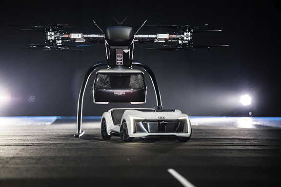
Audi, Airbus and Italdesign presented for the first time a flying and driving prototype of Pop.Up Next, a flying taxi. The companies demonstrated the concept at Drone Week, held Nov. 27-29 in Amsterdam.
The concept combines a self-driving electric car with a passenger drone. In the first public test flight, the flight module accurately placed a passenger capsule on the ground module, which then drove from the test grounds autonomously.
Photo: Audi
The demonstration was done with a 1:4 scale model. But as soon as the coming decade, Audi customers could use the flying taxi service in large cities — in multi-modal operation, in the air and on the road, without changing vehicles.
“Flying taxis are on the way. We at Audi are convinced of that,” said Bernd Martens, Audi board member for sourcing and IT and president of the Audi subsidiary Italdesign. “More and more people are moving to cities. And more and more people will be mobile thanks to automation. In future senior citizens, children, and people without a driver’s license will want to use convenient robot taxis. If we succeed in making a smart allocation of traffic between roads and airspace, people and cities can benefit in equal measure.”
To see what an on-demand service of this kind could be like, Audi is conducting tests in South America in cooperation with the Airbus subsidiary Voom. Customers book helicopter flights in Mexico City or Sao Paulo, while an Audi is at the ready for the journey to or from the landing site.
“Services like this help us to understand our customers’ needs better,” Martens said. “Because in the future, flying taxis will appeal to a wide range of city dwellers. With Pop.Up Next we are simultaneously exploring the boundaries of what is technically possible. The next step is for a full-size prototype to fly and drive.”
Audi is also supporting the Urban Air Mobility flying taxi project in Ingolstadt. This initiative is preparing test operations for a flying taxi at Audi’s site, and is part of a joint project of the European Union in the framework of the marketplace for the European Innovation Partnership on Smart Cities and Communities.
The project aims to convince the public of the benefits of the new technology and answer questions concerning battery technology, regulation, certification and infrastructure.
The value of accurate maps is not lost on the automotive industry as it transitions from connected cars to automated vehicles. Three German automakers are rumored to be making a multibillion-dollar investment in Nokia’s HERE mapping division. If the deal goes through as expected by late July, Nokia, which purchased HERE (then called Navteq) for $8 billion in 2007, will have spurned several deep-pocket suitors.
Although not officially confirmed, Nokia’s HERE digital mapping service is set to be purchased by a German auto consortium of Daimler, BMW and Volkswagen’s Audi unit, according to published sources.
Estimates of the deal place it in the $2.7 billion to more than $3 billion range. The potential sale puts to rest industry concern that Google or another giant non-automotive entity would make the winning bid for a company with increasing importance to connected and autonomous vehicles.
Either way, it’s too early to analyze what exactly are the consequences if the German consortium closes the deal with Nokia, said Thilo Koslowski, Gartner vice president and analyst. “In order to justify the purchase price of the acquisition, it will be in the interest of any acquiring party to keep Nokia HERE’s future role as neutral as possible in order not to alienate other clients,” he said. “I could imagine that contractually the acquiring party might be tied to serving these other clients for a least a certain time. If that doesn’t happen, and the deal would be ‘exclusive,’ then it would certainly boost the appeal of other map data providers and encourage new players to emerge.”
If the deal goes through, the German consortium plans to invite such other automotive companies as Fiat Chrysler, Ford, Renault, Toyota and General Motors, according to the Wall Street Journal.
Another take on the potential agreement could be whether car companies have to weigh the pluses and minuses of to join the consortium — or map competitor TomTom needs to consider whether it has more to gain from remaining independent or creating its own consortium, said Roger Lanctot, strategy analytics associate director, global automotive practice.
Industry old-timers may remember the bitter rivalry between Navteq (formerly Navigation Technologies) and Tele Atlas (formerly Etak). This rivalry has remained, even though the names have changed and the location industry has evolved dramatically since 2007, when both Navteq and Tele Atlas were bought by Nokia and TomTom, respectively, in multibillion-dollar deals.
The bidding war for HERE began in April, when Nokia purchased Alcatel Lucent to transition from the location industry. In addition to the German auto consortium, Uber and Chinese technology provider Baidu, Google and Apple were said to be potential buyers. However, Google’s purchase of HERE would have been disruptive to the auto industry, Lanctot wrote in a LinkedIn column. “Google buying HERE would drive the entire industry into the arms of TomTom while removing the leverage-ability of a map duopoly. Google buying both TomTom and HERE would annihilate billions of dollars in research and development activity by car makers seeking to create a truly driver-oriented browsing experience intended to enhance safety,” he wrote.
Mike Dobson, TeleMapics president, who writes about digital maps at www.telemapics.com, recently said that Uber was playing with fire by bidding on HERE because they were clearly concerned about autonomous vehicles. “Within 10 years, Uber will be producing its own fleet of [autonomous vehicles]. While owning a map company might be beneficial to them, they might be better off licensing map databases,” he said.
Uber, which bought mapping company deCarta and Microsoft’s Bing Maps, ultimately withdrew from the bidding war for Here.
City Built for Autonomous Testing Unveiled in Michigan
A 32-acre simulated city recently opened to test how self-diving cars will perform in the future. The $10 million facility, called Mcity and located on the north campus of the University of Michigan, was created by the school’s Mobility Transformation Center and the Transportation Research Institute.
With all the bells and whistles — a bridge, a tunnel, traffic circle, etc. — the facility will rival anything existing, if it hasn’t already surpassed it, in Silicon Valley or Pittsburgh, which seem to be the centers of gravity for the nascent autonomous vehicle industry.
Mcity, which was a government-industry partnership, plans to “lay the foundations for a commercially viable ecosystem of connected and automated mobility,” said a university press release. [Editor’s note: It is refreshing to see the “commercially viable” thrown in there by an academic institution.]
Another key goal is to implement a connected and automated mobility system on the streets of southeastern Michigan by 2021. The MTC is developing deployments of more than 20,000 cars, trucks and buses across southeastern Michigan, serving as testbeds for evaluating consumer behavior and exploring market opportunities, the university said.
At the same time as the Mcity announcement, also in Ann Arbor, the Automated Vehicle Symposium, which is the largest autonomous vehicle conference, was being held at a local hotel. While the conference had such keynote speakers as Google’s Chris Urmson, and sponsors that included Denso and Uber, it still has the feel of this government/academic/technical conference — not unlike TRB or ITS America.
In fact, like many government meetings, the afternoon “breakout sessions” were closed off to the press. This leads to the question, with so many new, and expensive, autonomous vehicle conferences springing up, why isn’t there a single panel on the future worldwide market opportunity?
In other location news:
IndoorAtlas signed a $3 million deal with South Korea’s SK Planet, a subsidiary of SK Telecom, to target the e-commerce market. IndoorAtlas’ investors include ST Planet and Chinese technology provider Baidu, which made a $10 million investment in the company.
Nokia’s HERE mapping and location services business is developing a new global standard for contactless transport ticketing payments using Near Field Communications-enabled mobile phones. HERE announced the formation of the Open Mobile Ticketing Alliance, or OMTA, to help consumers purchase public transit ticket using a mobile app.
HERE competitor TomTom continues to be a major force in vehicle monitoring and location, recently announcing its telematics division broke 500,000 subscribers. Overall, the company serve 36,000 customers, primarily in the European fleet market.
TomTom is making available Highly Automated Driving (HAD) map content in the metro Detroit area, where U.S. automakers are headquartered. Car makers and HAD-related companies can now use TomTom’s high-definition maps for precise vehicle positioning, enabling future self-driving cars to see beyond their sensors.
The HAD map, covering the stretch of road network between Farmington Hills and Ann Arbor, including I-696, 96, and 275, US-23 and M-14, will be available in June. TomTom discussed the HAD map in a session at TU-Automotive Detroit trade show, held June 3-4.
“By making high-definition map content readily available, we can make HAD a reality faster, enabling further innovation in Detroit, the heart of the North American automotive industry,” said Alain De Taeye, member of the TomTom Management Board. “Intense demand for high-definition maps is fueled by automated driving as a new growth driver. As an independent supplier with one of the world’s most sophisticated mapping platform, we are in a unique position to provide highly precise map content for all members of the HAD ecosystem.”
For the Consumer Electronics Show (CES) 2015 in January, the Audi A7 piloted driving concept car dubbed Jack used TomTom HAD prototype maps to complete a long-distance test drive, over 560 miles from San Francisco to Las Vegas.
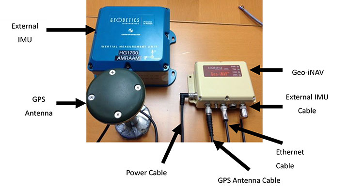
Differential GNSS+INS for Land Vehicle Autonomous Navigation Qualification
By Gilles Boime, Emmanuel Sicsik-Paré and John Fischer
Land-vehicle autonomous navigation requires centimeter-level qualification tools to enable confidence build-up for delivery to open-road traffic insertion. External positioning sensors over a dedicated road section can be replaced with an embedded high-accuracy, highly responsive epoch-by-epoch differential GNSS receiver coupled with an inertial navigation system. The demonstrated absolute accuracy and mobility extends the potential test area and minimizes cost for multi-environment validation.
Cover courtesy of Mercedes.
Personal cars and commercial trucks are continuously improving the driver experience and safety thanks to integration of more significant and machine-assisted control systems. Advanced driver-assistance systems (ADAS) are now integrated in all luxury cars and moving into mainstream products. Technologies covered by ADAS are specific for each car integrator, but increasingly they include now involving more safety features, such as driver assistance and partial delegation to autonomous control for small maneuvers such as lane control. The generation of ADAS systems introduced in early 2015 on high-end models are engaging more intelligence from the control system such as:
Lane departure warning system
Speed assistance and control
Driver assistance and control
Autonomous emergency braking.
It is not only individual drivers who want this technology, but also governments that are getting involved to prevent accidents and minimize the economic impact associated with them. In the European Union, the general safety regulation 2009/661 was the first step to engage member-states to act as a regulator to mandate car safety improvements. The European Transport Safety Council, a non-profit private association, released in March 2015 a position paper titled “Revision of the General Safety Regulation 2009/661.” It promotes the introduction of lifesaving technologies like intelligent speed assistance, autonomous emergency technology including all speed and pedestrian detection, and lane-departure warning systems as the next step of regulation.
Car manufacturers are not far behind. They understand their customers’ expectation of minimized risk and enhanced driving experience. Telematics is also a path to convert a single vehicle into a fully intelligent, connected and entertainment object with an associated high value. So every car manufacturer is willing to be seen as a technology master.
Toyota, for example, plans to integrate collision-prevention technology in all its mainstream and luxury cars by 2017. The ADAS new generation focuses on radar-activated cruise control technology for the collision-prevention system. The control system maintains distance from a vehicle ahead and can stop the car if driver doesn’t react. The next step is to monitor driver attention with sensors like cameras focusing on the driver’s eyes, and the pressure of the hand on the steering wheel.
However, no fully driverless car is expected in the next 10 years. This technology is limited by legal issues and the lack of reliable nationwide mapping data.
Since the technology must be fully proven to prevent any lethal threat on the user and other drivers, most car and truck companies are working actively on qualifying driverless technology today. Nissan began testing driver-assist technology on open-road traffic in Japan in late 2013. It enables highly advanced systems such as lane-keeping, automatic lane change, automatic exit, automatic overtaking of slower or stopped vehicles, automatic deceleration during congestion on freeways, and automatic stopping at red lights. This is a step towards attaining fully automatic driving, targeted for 2020 by Nissan.
Some European manufacturers such as Daimler Benz are also early adopters. Daimler/Mercedes uses the Bertha Benz prototype car to test autonomous driving technologies. It merged multiple vision, radar and GPS sensor with digital map to monitor an open-road 100-kilometer trip in August 2013 (Figure 1).
Figure 1. Bertha Benz test car, left, running fully autonomous 103-kilometer trip in open road including 27 percent narrow urban roads. Right, networked sensor systems of the S 500 Intelligent Drive research vehicle.
All manufacturers are building driverless capability into their technology demonstration concept cars:
Mercedes with F 015 Luxury presented at the Consumer Electronic Show, early 2015;
Audi with Prologue, an extrapolation of test car RS7 concept equipped with SuperFast driverless pilot;
BMW’s electric i3 car is integrating ActiveAssist technology that enables portions of drive to be without any manual intervention, such as car parking and autonomous rally to a meeting point;
Google’s self-driving vehicle that conforms to California license requirements for driverless tests in open traffic;
Tesla model SD autonomous test car.
Although most market leaders agree that this is not a technology for mainstream production in the next few years, they all work very efficiently to master the technologies. It is a big challenge to integrate all the sensors and the navigation functions to autonomously and accurately position the vehicle on a map. The whole system must be certified to prevent any liability in case of a crash, a case that would engage the solution provider and the vehicle manufacturer.
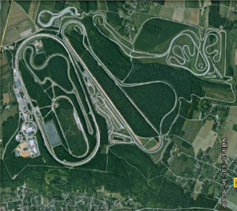
A large part of the qualification task will benefit from simulations and integration testing platforms in realistic conditions. At the very least, a very robust final open-space validation test must take place. Car manufacturers/integrators are using private test facilities in open air to perform serious trials before proceeding to real traffic conditions. Renault uses a 10-square-kilometer facility in France (Figure 2) to perform private tests in a protected area.
Figure 2. Renault outdoor test center at Aubevoye, France.
New autonomous car drive tests have mandated equipment enabling measurement of the car’s position on the track with an extremely high precision and repeatability. There are two competing technologies to do this:
Install many location sensors on the test track;
Use a general absolute positioning system.
Here we focus on an absolute positioning system that is affordable, easy to install and low maintenance. It is based on two main assertions:
The autonomous pilot can position accurately on the test track;
The test track is accurately referenced to the absolute positioning system.
We focus more closely in this article on the first assertion; the second one can be covered with a specific calibration trial where equipment, as discussed further, can be used in quasi-static mode and experience consistent accuracy. Let us have a deeper look at the candidate position technologies to verify autonomous pilot accuracy.
Positioning Technologies
Many technologies have been proposed to obtain vehicle position on the course. However, they all must be compatible with a reliable mapping database. Given the lack of consistent road infrastructure equipment with alternative capabilities, GNSS positioning is the sole enabling method to fit to a map every place around the world. That is why driverless systems always include a GNSS sensor to help other data matching with the map. The versatility and low cost of GNSS positioning makes it a candidate for open-air validation as well.
Standalone Standard Positioning Service GPS. The SPS single-frequency GPS receivers are included in so many nomadic appliances today that they are a commodity. Since their introduction 20 years ago, their performance is well understood. Some trials were performed in different area profiles with satellite constellation position dilution of precision (PDOP) < 2. Worse results were obtained from deep urban canyons in downtown Seattle, Wash.
For every technology, the relevant performance for the test course is the lateral error to the expected center of the lane in the two horizontal dimensions, referred to as 2D or N/E for orientation north and east.
For standalone SPS GPS, the lateral error standard deviation in 2D can be as high as 46 meters and have peak errors up to 660 meters. Lateral error in 3D can be as high as 20 meters with peak errors up to 175 meters.
Such performances are out of range for any positioning verification. It can only deliver a rough estimate of the point on the map, but would not provide tight correlation with other sensors for the navigation system.
Hybridized IMU and SPS GPS. Coupling of an absolute navigation GPS receiver with an inertial measurement unit (IMU) can mitigate corruption of the navigation solution when intermittent GPS signal outage is encountered. The hybrid approach is beneficial on any difficult signal transmission path from the satellite that is not line-of-sight: in urban canyons, deep foliage, under bridges, tunnels and in any multipath area. It also yields benefits in the very short term (less than a few seconds) for dispersion on the position computed from the sky.
Over the last 10 years, the combined benefits of micro-electro-mechanical sensors (MEMS) and tight coupling algorithms have raised the bar of positioning accuracy. It enables smoothed position along track and dead reckoning (DR) in case of GNSS signal outage.
Lateral error standard deviation in 2D is lowered to 2.3 meters and peak error up to 10 meters. However, this performance is still too poor to validate a vehicle position in the lane.
Hybrid Differential Single Frequency and IMU. The next step to mitigate systematic errors of the GNSS system is to use a set of multiple reference receivers in the vicinity of the area covering the test course. The reference receivers are static. The position of the reference is determined using long-term averages to mitigate constellation errors. A minimum for a position fix of 20 minutes is commonly reported. Then the position error standard deviation in 2D is less than 2 centimeters for baselines shorter than 100 kilometers.
For a MEMS integrated with a standard SPS GPS single-frequency receiver with DGPS correction on a mobile platform moving at less than 70 km/hour with HDOP < 1.4, Table 1 compares performance in a 2013 test.
Hybrid Differential Dual-Frequency Carrier Phase and IMU. The GNSS solution can be further improved, taking into account both L1 and L2 frequencies to mitigate propagation error and carrier phase to achieve ultimate signal accuracy. The combination of both helps solve ambiguities associated with the carrier-phase technique. When combined with a MEMS IMU, accuracy confirmed with HDOP < 1.6 is:
Lateral error standard deviation down to 0.18 meters;
Peak error of 0.6 meter.
However, this is still insufficient accuracy when compared to 0.1 meter required for verification testing.
With such low-cost IMU, GPS outages produce a rapidly increasing lateral error over elapsed time. The lower the speed, the poorer the position result.
Another limitation common to many differential solutions is the turn-on delay for the solution. It is also a repetitive issue in case of disruption of the GNSS solution. It extends the delay to recover from DR situation.
Geodetics’ Epoch-by-Epoch
Geodetics Inc. has developed a new class of instantaneous, real-time precise GPS positioning and navigation algorithms, referred to as Epoch-by-Epoch (EBE) and employing hybridized dual-frequency differential GPS with a high-performance IMU.
Compared to conventional real-time kinematic (RTK), integer-cycle phase ambiguities are independently estimated for each and every observation epoch. Therefore, complications due to cycle slips, receiver loss-of-lock, power and communications outages, and constellation changes are minimized. There is no need for the initialization period (several seconds to several minutes) required by conventional RTK methods.
More importantly, there is no need for re-initialization immediately following loss-of-lock problems such as those that occur when a mobile GPS receiver passes under a bridge or other obstruction, or when it loses satellite visibility during a shaded portion of road. In addition, EBE provides precise positioning estimates over longer reference-receiver-to-user-receiver baselines than conventional RTK.
This feature supports testing for long-range operations, for example, such as positioning a vehicle on a lane. The reference receiver is set in the vicinity of the test center track.
EBE requires the use of a minimum of two receivers, each of which is tracking a common set of five or more satellites and providing simultaneous dual-frequency phase data. Typically, one of the receivers is stationary, but this is not a requirement.
EBE has been proven utilizing dual-frequency receivers and operating at distances of up to 50 kilometers from the nearest base station in unaided mode. Additionally, the EBE algorithms operate in a network environment and make optimal use of all GPS measurement data at each epoch, gracefully degrading the position accuracies when some measurement data are not available. Furthermore, the system will make use of an IMU system, compensating for outages when line-of-sight to the satellites is blocked. This produces a robust and more reliable system.
Epoch-by-Epoch can deliver several benefits including:
Computationally efficient algorithms that provide a position estimate based on a single epoch in several milliseconds. This allows the real-time position estimate to be computed on the user platform (assuming reference station data is sent to the user platform).
An initialization period is not required. Since RTK requires some period of time (that can be measured in seconds to minutes) to perform ambiguity resolution, this is an important capability for platforms that:
require high accuracy (for example, for end-game scoring);
cannot see the satellites until launch;
have short flight or test course duration;
A re-initialization period following loss-of-lock is not required, unlike RTK, which needs to restart the integer-cycle phase ambiguity resolution process. This is another important capability because vehicle monitoring is considering EBE for dynamic applications where loss-of-lock and loss-of-data are likely.
However, it must be mentioned that many of the GPS receivers in use by the test (and training) community today do not support this dual-frequency requirement. Hence, those systems could not realize the maximum benefit.
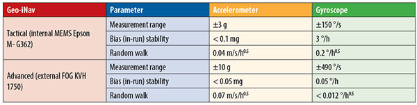
This technology is implemented in a rugged modular platform (Figure 3) with three main units:
A dual-frequency GPS antenna,
An integrated INS coupling GPS receiver with either an internal MEMS IMU or external IMU,
An external fiber-optic gyroscope (FOG) IMU for high-end accuracy and reliability. The external IMU is optional and dedicated to increasing the DR capability.
Figure 3. Dual-frequency differential navigation unit hybridized with external fiber-optic gyro.
Performance. Tests have been performed in conditions close to the land-vehicle navigation validation. It is based on measurements on-the-fly with no post-processing except for evaluation of the error.
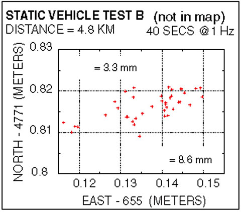
The first case is a static position of the rover 4.8 kilometers away from the reference receiver. Positions are updated once per second. The system includes a FOG IMU. the lateral error peak is less than 4 centimeters. Bias error is less than 1 centimeter. See Figure 4.
Figure 4. Single point error when rover is static.
The second test case is with a high-dynamic mobile platform, moving at a speed of 200 km/h, with an average distance from the reference to the rover of 6 kilometers. Lateral error standard deviation is 0.5 centimeters, peak error is less than 2.2 centimeters. Bias error is lower than 0.2 centimeters (Figure 5).
Figure 5. Dynamic trial test single point error.
The performance in these test cases meets the expected accuracy for validation of autonomous navigation.
One last method to increase accuracy is to switch to a different class of IMU performance, from tactical grade to advanced. When in the line-of-sight of the GNSS sky-view, the performance is the nearly the same.
Conclusion
A real-time, differential Epoch-by-Epoch, dual-frequency carrier-phase GPS receiver, tightly hybridized with a high-performance IMU can provide absolute error lower than 5 centimeters in the 10-kilometer baseline range of the reference static receiver. This is fully adapted to the qualification of driverless auto-pilot systems for the targeted year of 2020. It can avoid the need to use complex theodolite and vision calibration systems. It provides maximum flexibility and minimum sustaining costs.
Acknowledgment
This study has been made possible thanks to materials provided by Geodetics Inc. and the advice of Jeffrey A. Fayman, vice president, Business & Product Development, Geodetics Inc. The results displayed in Figures 4 and 5 are from a test with a medium-sized UAV from Allied Drones, model EF44 high-endurance quad.
Manufacturers
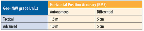
The Geo-iNAV family is a range of GPS-aided INS solutions available in different configurations, including various GPS receivers (L1, L1/L2 RTK, SAASM), internal MEMS or external FOG IMU. As part of this family, the Geo-RelNAV provides differential GPS relative navigation capability, the Geo-hNAV includes a dual GPS antenna receiver for static heading measurement capability, and the Geo-PNT combines position and attitude measurement with precise timing distribution.
Gilles Boime is is chief scientist for Spectracom. He is involved in GNSS signal generator, hybridized navigation platforms, GNSS timing and synchronization innovative solutions build-up. He holds an engineering diploma in telecommunication from Institut Superieur d’Electronique de Paris.
Emmanuel Sicsik-Pare is strategic product manager for Spectracom. He is involved in timing and navigation products and systems definition and application market monitoring. He holds a M.Sc degree from Telecom Bretagne.
John Fischer is CTO of Spectracom. He has more than 30 years experience creating navigation and communications systems, received his master’s in electrical engineering from SUNY at Buffalo. Prior to joining Spectracom, he worked in radar, command and control, and wireless systems.
This year’s Mobile World Congress in Barcelona was the biggest ever, with 95,000 attendees and thousands of booths, conferences and people with sore feet walking a cavernous exhibition hall. While the Geneva Auto Show ran close to the same dates, connected vehicle companies and technology were prominently featured. What was interesting, however, was the rise of indoor positioning companies and mobile advertising agencies with interest in location.
BARCELONA — Joining the 95,000 or so Mobile World Congress attendees were about three dozen companies who are offering indoor location and location advertising services. These companies have exhibited at previous conferences, but not in the numbers this year.
At the huge Fira convention center where MWC was held March 2-5, Los Altos, Calif.-based Pole Star installed more than 600 beacons for indoor location. Visitors were able to be guided to booths and other areas through an interactive map. “Business was good in 2014, we sold 10,000 beacons. We are making money,” said Christian Carle, Pole Star CEO.
One analyst said that the big change at MWC wasn’t the number of indoor positioning companies and demos, but the maturity and breadth of the technology. “Intel announced indoor positioning capabilities in their Wi-Fi chip, and had a demo that was very impressive. Many smaller companies that in past years were showing raw technology were showing polished solutions this year, such as Quuppa, MTI and Sensewhere, said Bruce Krulwich, Grizzly Analytics president, who has authored a report identifying 150 indoor positioning companies. “I definitely see a shake-out coming up, but it won’t be one technology prevailing over another. Different technologies meet different needs in the industry, and different technologies fit different sites. There are technologies that deliver universal indoor positioning, without any infrastructure or preparation, such as Wi-Fi multilateration and sensor fusion.”
Krulwich said that there is a shake-out that’s already started because there are too many companies working on similar technologies. “Start-ups in the area that don’t have differentiating innovation, don’t have integration into retail or other back-end systems, and don’t have market penetration, are already finding themselves in a challenge. But companies with clear innovations and commercial deployments will do fine,” he said.
United Kingdom-based Sensewhere is using crowdsourcing in its indoor positioning software. The software uses radios to scan for Wi-Fi and Bluetooth to allow an IP location to reference the sources and form a location database.
“It’s what we call the universal indoor positioning versus venue specific indoor positioning, which can work anywhere — we just need a crowd of people. Our target partners are handset manufacturers, network operators, social media, social network providers, and also chipset guys as well,” said Rob Palfreyman, Sensewhere CEO. “So, there are obviously a lot of companies like Google looking at venues; there is Micello and TomTom looking at add-ins in the indoor location, which is great news, but it just needs to have a technology that can drive the blue dot on their map, and we feel that Sensewhere is the right place to provide that blue dot because of the crowdsourcing global nature of our approach.”
One company, which has developed a popular mobile game, is using its network to attract advertisers for its location-based ad platform. “We already have the infrastructure in place because of our mobile game. With our platform, we can allow advertisers to launch campaigns using our beacon signals and geofencing,” said Pedro Jahara, CEO of Brazil-based RevMob.
New location technology like the ability to track SIM cards was rolled out at MWC. W-Locate, which is partnering with Morpho in Thailand, is tracking SIM cards with its XimLoc product, which the company said is more accurate indoors than other technology.
Even such companies as Geotab, which is a strong player in the fleet market, are leveraging MWC to continue a foothold in the European market. The company displayed its IOX-CAN system that can send data from a mobile device to the MyGeotab system, which can be viewed an analyzed by fleet managers, said Maria Sotra, Geotab marketing manager.
Geotab also partnered with Telefonica in November 2014 to focus efforts in Spain, Germany and the United Kingdom, Sotra said.
At MWC, location-based advertising market is gaining traction as advertisers are seeing the benefit of locating and attracting customers. New York-based xAd said it has doubled its revenue for the second year. “We have billions of mobile ads processed and billions of ad impressions. The company is profitable,” said Dipanshu Sharma, xAd founder and CEO.
He said the company has expanded into France and Germany and added China to its global ad network.
Another company that is using location technology as a differentiator is Airpush, which had another big presence at MWC. The company’s Abstract Banners was a big draw to attendees. Location, particularly geofenced areas, have created a call to action for consumers, which is attractive to advertisers, said Cameron Peeples, Airpush vice president of marketing.
Connected Car Still Big Opportunity at MWC
Although the Geneva Auto Show was starting as the MWC was ending, there were still several big announcements by connected car companies in Barcelona. Even the well-publicized Samsung S6 and S6 Edge and HTC One M9 handset rollouts included Mirrorlink, the connected vehicle standard from the Connected Car Consortium.
In another big announcement, Audi and AT&T said that all 2016 model vehicles equipped with Audi connect will come with the carrier’s 4G LTE or 3G coverage. This increase in services is big because the auto giant just rolled out 4G AT&T service in Audi A3s last year.
AT&T selected Airbiquity to provide end-user registration and device management connected vehicle services for select customer programs. “Airbiquity will deliver these services to AT&T using our Choreo cloud-based connected vehicle services delivery platform and project management, engineering, and operations teams,” said David Jumpa, Airbiquity chief revenue officer. “This is a ‘white label’ agreement whereby AT&T will integrate Airbiquity’s service delivery capability into AT&T’s connected vehicle customer solutions.”
Another location company is making huge inroads in connected vehicle markets with its Glympse for Autos product. Glympse will be installed in select Volkswagen and Peugeot models through MirrorLink, said Bryan Trussel, company co-founder and CEO.
The app allows users to share location from their vehicle by setting the recipient and timer, and hitting send. The company has a similar app for Gogo inflight aviation networks to allow a person on the ground to know where an airplane is for picking up passengers.
In other connected car news, Accenture is providing Fiat Chrysler Automobiles the capability of in-car, Internet-based services. Starting with the new Fiat 500X, Uconnect Live services, which was co-developed by Accenture, will power an infotainment system that offers music and news services, social network access, the ability to monitor driving style and a range of diagnostic services.
Accenture also partnered with Visa for an IoT-based connected car commerce test. At MWC, the company tested a scenario where drivers could order food from the car using cellular, Bluetooth and beacon connectivity. Accenture deployed a similar system with BMW’s ConnectedDrive, which allows customers to choose services in real time for a vehicle.
Health Market Even Has Location Potential
Niche location applications are growing as Internet of Things, or IoT, markets start to grow. One company taking advantage of the mobile market is Annapolis, Md.-based TCS, which featured its VirtuMedix platform in its MWC booth.
The platform is tailored to emergency physicians as part of the growing market for video telemedicine products and mobile health, said Jay Whitehurst, TCS commercial software group president. “It’s already saving lives,” he said of the platform, which combines encryption, navigation, mapping and messaging.
While the product, now being rolled out in a North Carolina emergency medicine group, provides patients with an alternative to urgent care centers and emergency rooms, it also can be used for longer term cases such as assisted living and rehab centers, the company said.
Whitehurst said TCS has made several company acquisitions that have played a part in new product rollouts, which include the company’s Trusted Location. The application allows financial firms, online gaming companies and others to identify and prevent credit-card fraud. The application identifies and validates a device’s location worldwide.
In other Mobile World Congress news:
Spirent said its simulators have the capability to evaluate Wi-Fi Offload and Wi-Fi performance of mobile devices on its test framework. The new product allows companies to test multiple devices on a single unit to cover Wi-Fi/LTE mobility and interoperability. The testing is important in light of wireless carriers’ strategy to extend VoLTE in areas where cell coverage is limited, said Saul Einbinder, Spirent vice president, venture development.
Google Waze said its Google Mobile Service (GMS) will be available as a preinstall option on mobile devices. OEMs and carriers can preinstall the app on their handsets so consumers can use the service immediately, the company said.
Trimble’s ALK said its ALK Maps and route visualization software is now available in Europe. ALK Maps, launched in the United States in 2012, allows users to overlay routing, geocoding points, weather and other features, the company said.
Driverless cars are now traveling Britain’s public roads, according to a report in the Providence Journal. Four prototype self-driving cars took to the country’s highways, launching Britain’s first public trials. Still, with regulatory and legal hurdles, officials said fully driverless cars are unlikely to be used on British roads until 2030.
Four types of autonomous vehicles are being tested, including a shuttle that looks like a larger golf cart and a compact two-seater “pod.” Journalists took rides on the shuttle, which traveled a public square outside central London’s O2 Arena.
The project was “still in the early days,” Transport Minister Claire Perry told the Associated Press, but she added the new technology has the potential to make roads safer and attract global investment.
Driverless cars are also being tested in U.S. cities by companies including Google, and Apple and Sony are at least exploring autonomous vehicles. Meanwhile, automakers such as Audi, Mercedes-Benz and Nissan are developing autonomous cars, and Volvo expects to test its self-driving cars on customers by 2017. The widely discussed goal is to have autonomous vehicles on the market by 202o.
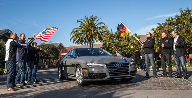
Start of the 550 mile piloted drive from Silicon Valley to Las Vegas: Ricky Hudi, Executive Vice President Electric/Electronic Development, (left) and Ewald Gössmann, Excecutive Director Electronic Research Lab California (ERL), (third from right) drop the flag for the Audi A7 piloted driving concept car. Photo: Audi
In the wake of CES and the North American International Auto Show in Detroit, it’s clear that times are a-changing. Self-driving concept cars filled three football-field-sized areas to show off what lies ahead. Verizon and Ford did a cosmic switcheroo, with Verizon morphing into the auto space and Ford starting a transformation into a mobility company. Automated reality/augmented reality isn’t as big as would be expected, and is suffering from a lack of content. Wearables continue to do remarkable things, notably in the health and fitness sector, and smart watches will become more exciting with interaction to vehicles and home.
Janice Partyka
When Mark Field, current CEO of Ford, announced the Ford Sync from the CES stage in 2007, attendees found the presence of an auto company at CES to be out of place. The auto industry was considered Neanderthals of tech. Today, the most exciting mobile technology is vehicle related, and more exciting developments from the auto industry were seen in Las Vegas, rather than Detroit.
Field was back at CES with a visionary perspective that Ford isn’t going to be just about cars and trucks. He is broadening Ford’s focus to mobility in preparation of the changes in transportation that will occur in response to global megatrends of urbanization, growth of the middle class, air-quality issues and evolving consumer attitudes. To test out new ideas of flexible user-ship and collaborative transportation, Ford is operating 25 experiments around the world to test out solutions for specific mobility challenges. Ford is looking to be a leader and enabler of a market where people may be sharing or swapping vehicles or relying on crowd-based transportation. It is refreshing to see out-of-the-box thinking from Detroit.
Ford Mobility Experiment in London — driving-on-demand with Ford fleet. Photo: Ford
Far from its beginnings in 2007, Ford announced SYNC 3, an updated version of its in-vehicle communication and information system. SYNC technology is already in 10 million vehicles on the road. SYNC 3 will be released in new car models this year and will include more conversational speech recognition, a more smartphone-like experience with a touch screen and easier-to-read graphics. In addition, AppLink 3.0 will roll out and give drivers the ability to access their navigation app — much as they do on a smartphone — on in-vehicle touch screens.
SYNC 3 has been designed to keep the drivers eyes on the road and hands on the wheel, even when controlling their favorite phone apps. Photo: Ford
You may recall that GM had announced OnStar would be dropping Verizon for AT&T communications staring in 2015. The announcement of Verizon Vehicle, a new connected vehicle service that duplicates some of the features of OnStar, must be the impetus. The subscription-based service will be compatible with all vehicle models sold in the U.S. since 1996. The service will include GPS-directed roadside assistance, crash notification, emergency assistance with a live agent, a hotline to connect with mechanics on vehicle issues, maintenance alerts, and stolen vehicle location assistance. Notably, the offering doesn’t include navigation, a mainstay of OnStar, but readily available on smartphones. The service uses an OBD II dongle and a head unit that can attach to a visor and contains a Bluetooth speaker and call buttons.
Mercedes-Benz, Audi and BMW all showed advances in self-driving vehicles. Mercedes-Benz demoed the F015 Luxury in Motion concept car, which is fully autonomous and completely powered by a battery and fuel cell. Audi impressed by having its own concept vehicle drive itself from Palo Alto, California, to Las Vegas. BMW offered demonstrations of its i3 electric car, with ActiveAssist technology, able to prevent collisions at speeds up to 15 mph.
Delphi and Valeo technology suggest that current adaptive cruise-control systems may soon add self-steering. Drivers could allow the car to take over in stop-and-go traffic and on long highway segments. Although unlikely to see production in the short term, Delphi showed the full capabilities of its self-driving technology in an urban environment.
The next big feature to be commercialized during our wait for automated driving is self-parking. As demonstrated by BMW, the driver arrives at a parking garage entrance, gets out of the car, and sends it to find a parking place. When ready to depart, the driver summons the car, which drives itself to a special pickup zone in front of a parking garage. BMW says it will be offering self-parking cars in one to two years.
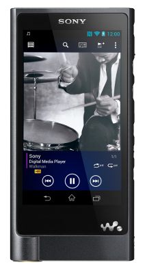
The Sony Walkman, now $1,100. Photo: Sony
Unfortunately, augmented reality hasn’t quite lived up to the hype, but Hyundai is showcasing a production-ready augmented reality heads-up display concept. It’s an easy-to-understand system with animated information and warnings to describe road conditions ahead. For instance, it provides warnings when another car is about to unexpectedly enter the car’s lane, and shows arrows leading to exit ramps, highlighted street signs and one-way street markings. Hyundai has linked the augmented heads-up display to a wearable band that will vibrate with warnings. The band includes a heart-rate monitor that can notify 911 if a driver’s heart rate changes rapidly.
I don’t want to neglect the things in life that don’t change. It is comforting to know that Palm Pilots, record players and Walkmans are back at CES. The new Sony Walkman will set you back $1,100. So things do change.
Start of the 550-mile piloted drive from Silicon Valley to Las Vegas: Ricky Hudi, Audi executive vice president electric/electronic development (left) and Ewald Gössmann, excecutive director Electronic Research Lab California (ERL), (third from right) drop the flag for the Audi A7 piloted driving concept car. Photo: Audi
An autonomous Audi A7 is driving itself to Las Vegas for this week’s 2015 Consumer Electronics Show. The Audi is making the 550-mile trip as journalists sit behind the wheel for 100-mile stretches with an Audi official in the passenger’s seat.
The car left Stanford, Calif., Jan. 5 and traversed real-world roads and traffic conditions on its way to Las Vegas.
The long-distance test drive of the Audi A7 piloted driving concept car is designed to show that unprecedented performance can be achieved with series production technology, Audi said in a statement.
“The test drive from the west coast of California to Las Vegas demonstrates our leadership role in piloted driving,” said Prof. Dr. Ulrich Hackenberg, Audi board member and head of technical development. The test drive in real world traffic and road conditions represents a joint effort by the Volkswagen Electronics Research Laboratory (ERL) und Volkswagen Group Research and Development, begins today in Stanford, CA. The Audi A7 piloted driving concept will drive more than 550 miles, approximately 900 kilometers.
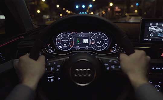
The A7 piloted driving concept uses the latest technologically advanced systems developed by Audi. The concept relieves the driver of driving duties from 0 to 70 mph, or just over 110 km/h. The car, named “Jack” by the development team, can initiate lane changes and passing maneuvers. In addition, the A7 piloted driving concept accelerates and brakes independently. Before initiating a lane change to the left or the right, the vehicle adapts its speed to surrounding vehicles. If the speed and distance calculation is deemed safe, the vehicle initiates the lane change with precision and in a timely manner.
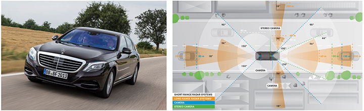
The piloted concept vehicle uses a combination of various sensors, many of which are close to production ready. The long range radar sensors of the adaptive cruise control (ACC) and the Audi side assist (ASA) keep watch of the front and rear of the vehicle. Two mid-range radar sensors at the front and rear respectively are aimed to the right and left to complete the 360 degree view. Laser scanners are mounted within the Singleframe grille and the rear bumper skirt. The scanners deliver redundant information to provide detailed recognition of static and dynamic objets during piloted driving. The technologies are production ready including their vehicle integration and cost structure for vehicle production in the near future. A new high-resolution 3D video camera, already integrated into the next-generation systems found in the new Q7, takes a wide-angle view out in front of the vehicle. Four small front and rear mounted cameras view closer surroundings. Navigation data is used for basic vehicle orientation.
Before the piloted driving system reaches its limitations, in city environments for example, the driver is requested to take control of the vehicle to ensure proper safety. Multiple warning signales work in unison: colored LEDs at the base of the windshield, signals in the driver information display, a Central Status Indicator (CSI), as well as a acoustic warning indicator requires the driver to retake control. Should the driver ignore the signals, the system activates the hazard lights and brings the car to a full stop while minimizing any risk. In most instances the vehicle is stopped on the right emergency lane.
The training for the jounalist test drivers taking part in the 550-mile trek took place several weeks ago at the Arizona Proving Grounds. Each journalist will drive approximately 100 miles using the piloted driving system. A trained Audi professional test driver will accompany the media from the passenger seat for added safety.
Macy’s added Shopkick indoor location beacons in preparation for holiday shopping. (Photo by Nicholas Eckhart is licensed under CC BY 2.0.)
This year was filled with hope and some success for the location industry. In what was probably the biggest deal, Qualcomm bought United Kingdom-based CSR for $2.5 billion — at the same time, spinning off its own location beacon company, Gimbal. While the connected car continued to get a lot of press at the biggest trade shows, indoor location technology matured to a point that many retailers are believing it’s a way to get consumers back into the stores — and away from their computers.
As we come to the end of 2014, many industry observers view indoor technology and markets to be like where outdoor location was in the early 1990s: many technologies and providers all pushing different solutions. However, the gap between the beneficiaries of the market, the retailers and brands, and the indoor location technology providers is narrowing as tests become more prevalent.
Such retailers as Walgreens, Home Depot, Lowe’s, Macy’s and CVS have rolled out, or planning to launch, tests that include indoor mapping and a product locator.
“iBeacons and other beacons proved to be the fastest location-proximity technologies that are being deployed full scale by Macy’s, CVS and other retailers for a first quarter 2015 rollout,” said Kris Kolodziej, an indoor location-based services advisor. “I see more acquisitions like the one of Groupon acquiring Swarm Mobile, a beacon platform for smaller tier-two retailers and businesses. In addition, we will see more partnerships like the one between Gimbal and Urban Airship to provide a holistic outdoor-indoor solution for geofencing and engagement platforms.”
Location companies paid attention to mobile carriers’ focus on launching and advancing their LTE services in 2014, said Keith Bhatia, TeleCommunication Systems vice president, business development.
“2014 has been the year of transitioning location-based services from 2G to 3G to complete 2G-3G-4G platforms,” he said. “The other significant location market event for TCS during 2014 has been growth of user plane services by (over-the-top) apps. The operators who have chosen to compete with OTT players have seen location requests exponentially expand.”
TCS believes that the location market, in the next five years, will evolve to a machine-to-machine and Internet of Things (IoT) concepts that will expand into consumers’ everyday lives, Bhatia said. “From the connected car to telemedicine, health devices, connected home and smart cities, all mobile connected devices will benefit from location-based services,” he said. “We believe that location services will continue its rapid growth for years to come.”
Selling retails on the promise of indoor positioning and proximity marketing has been tough in the past few years — and some providers have focused on the wrong message, Bhatia said. “As mobile device adoption continues to surge, indoor positioning and proximity marketing will become an important tool for many retailers. A significant barrier so far has been too much focus on coupon delivery,” he said. “We believe the retailers will find real benefits in terms of understanding layout, traffic and congregation of users. Combining this location information with their retail data will provide early insights into trends and early indications of potential challenges.”
Dave Hutingford, CSR director of product line for location, believes the big selling point for retailers is striking the balance between what benefits they obtain from the app versus what benefits the consumer gets — what he calls the equity balance.
“Too many irrelevant notifications while walking around the shop will result in people not wanting to run the app, and can potentially harm consumer acceptance of retail applications. The interest is already there from the retailers’ side as the benefits are somewhat obvious, but the question is what do you give back to an increasingly technology-smart consumer?” he said.
Overall, the indoor location market is attracting major interest from retailers — which is refreshing to many industry observers after seeing online sales cut into brick-and-mortar stores’ profits.
“Removing the need for dedicated infrastructure to run indoor location was a big hurdle removed from the ecosystem. Certainly we expect to see good pick-up of the solution over the next few months for a wide variety of location services, and being handset-agnostic is a big benefit for any developer,” Hutingford said. “However, if you are looking for accuracy down in the meter range, you will need to add infrastructure to supplement the location calculation, which can come in many forms.”
Connected-Car Market Made Headlines in 2014
If an industry executive attended any of the bigger trade shows this year — CES, CTIA in Las Vegas, or the Mobile World Congress in Spain, it was the same thing — connected vehicles are the big story. Adoption by automotive manufacturers, as a number of analysts have pointed out this year, was the most important news story for the connected-car industry in 2014, said John Horn, Kore Telematics executive vice president and chief strategy officer.
“Essentially every vehicle that rolls off the assembly line in 2015 will have an element of connectivity built into it. To keep up with the level of demand, we are starting to see scale and scope really start to matter to the companies that power this type of connectivity,” he said. “2015 will prove to be another huge year for industry consolidation, which will be necessary to keep up with the global demand for connected-car technologies.”
The biggest trend in 2014 connected-car technology was the emergence of infotainment content for connected cars, said Scott Frank, Airbiquity vice president, marketing. “Before 2014, the most an average consumer would expect out of a high-end vehicle head unit were features like navigation, basic cell-phone connectivity, and hands-free calling,” he said. “Today, drivers are able to get a wide-variety of apps in their vehicles to do things like stream music and keep up with their social media channels. User experience advancements were also made to provide a seamless transition for digitally oriented drivers as they moved from office, to car, to home, and back again. For example, with the NissanConnect Mobile Apps system, someone listening to a streaming music app like Pandora on their PC in the office can put it on hold, get into their car for the drive home, and pick up the song right where they left off — as well as see their favorite playlists, album selections, and cover art.”
However, as with any industry that experiences quick growth, there will be growing pains, Horn said. “The automotive world has already started to experience some of those pains as connected technologies continue to advance at a rapid pace. We saw how the analog shutdown left many OnStar customers stranded with obsolete hardware,” he said. “We’ll likely see similarities as 2G, 3G, and 4G networks are eventually turned down in favor of more advanced technologies. I’ve been saying this for years, but now is really the time for the removable module. Connected technologies will turn over much faster than cars, and the only way I can see to future-proof against this is through the removable module.”
Airbiquity’s Frank said that there are definitely consumer acceptance and technology barriers for the automotive industry going forward related to connected car as we know it today and autonomous car as its being forecast going forward.
Like waves of technology that have come before, functional consumer awareness and adoption will follow the technology adoption curve, Frank said. “Certain generations and user types will be early adopters and more likely to accept new and evolving connected-car technology and features — and the user experiences and value that come with it — the minute it’s made available,” he said. “While others will be either blissfully unaware of the technology built into their car — and the value it could bring them — or are simply satisfied with traditional technology like basic AM-FM and satellite radio. One thing for sure is there’s a correlation between early adopters of technology like smartphones and early adopters of connected-car technology and related features.”
Frank quoted a recent Parks Associates study that found 48 percent of vehicle owners that own smartphones are very interested in the ability to view maps — or receive directions in their cars. This compares to 37 percent of vehicle owners that own/don’t own smartphones. “Like flip-phone users that transitioned to smartphones after understanding the end benefits, consumers will increasingly become aware of and use their connected-car systems,” he said. “We’re seeing evidence of the connected-car adoption curve in the increasing activation rates and time of usage for our customer’s connected-car programs.”
Horn, who headed RacoWireless, which was acquired by Kore for an undisclosed amount this year, said in 2015 industry will start to see the connected car become much more easily monetized. “We’ve seen this first hand, as we have just rolled out some new features with AT&T and Audi. Now, your Audi Connect subscription can be part of your AT&T Mobile Share plan and treated just like another line,” he said. “It is going to be easier than ever to consume in-vehicle connectivity and the business model will advance to the point that makes it appealing for both the consumer and the solution provider.”
In 2015, driving-centric apps and services will begin to appear and eventually become as important as infotainment content in the consumer purchasing process, Frank said. “The current automotive manufacturers’ focus on providing infotainment delivery reflects their desire to meet the expectations of digital lifestyle consumers who are heavy users of smartphones and want to use their favorite apps and services inside their cars,” he said. “This is a logical first step, but these savvy consumers will increasingly value apps that are truly useful and relative to the driving experience. An example is an app that proactively and dynamically recommends modifications to a driver’s high-frequency routes to help them optimize fuel consumption, lower CO2 emissions, minimize engine wear, and avoid road hazards. As a result, apps that don’t add to the consumer experience relative to driving will eventually die off from lack of use, and automotive manufacturers will replace them with more and more driving-centric apps to satisfy their customers and differentiate themselves from competitors.”
The rise of autonomous vehicles, a derivative from connected-car technology, will keep automakers, carriers, suppliers and government agencies busy for decades.
“When it comes to autonomous vehicles, we expect the adoption curve to be more extended than what we’ll see for the connected car, given the increased consumer concerns about safety and adapting to the new fangled idea of riding in a car without a human driver,” Frank said. “Consumers will not only want to know what this fancy new technology is and how it works, they will also need to feel confident that it will run perfectly and not put themselves, their passengers, or other people and property in harm’s way. Consumers will also have concerns about who will be legally and financially liable if an accident occurs.”
In other location news:
Two Trimble companies, PeopleNet and ALK, recently provided real-time tracking of the 2014 Capitol Christmas Tree’s cross-country journey from the Chippewa National Forest in Minnesota to the front lawn of the U.S. Capitol Building in Washington. The companies used enterprise products for routing, mileage, mapping and visualization to track the tree.
LBS Insider’s Kevin Dennehy will be attending the 2015 Consumer Electronics Show in Las Vegas next month. Please contact him at [email protected] with your story ideas.
Drivers looking for parking account for up to a third of all traffic in major cities, according to INRIX, a provider of traffic information, directions, driver services, apps, and tools to car makers and other businesses. The company’s proudct Park Service provides drivers with continuously updated pricing, hours, and availability information for participating off-street parking locations in North America and Europe. The service will be available immediately with all active Audi connect accounts. In the U.S. market, the service brings new benefits to more than 100,000 Audi models on the road today.
More than 18,000 parking locations in the U.S. and 42,000 more across Europe participate in the program. With the INRIX Park, Audi connect customers gain the ability to easily compare rates, gauge proximity to their destination and get turn-by-turn directions to parking entrances. The roster of available parking destinations will continue to grow as data on the locations and available spaces builds.
“Together with Audi we’re making it easier to get new integrated navigation services in your vehicle than it is to update your smartphone,” said Bryan Mistele of INRIX. “With drivers looking for parking accounting for up to a third of all traffic in our cities, INRIX Park demonstrates how new data driven services can help drivers save time and frustration on the road.”
Today, some of the most exciting innovations in consumer electronics aren’t the ones in your living room or your office — they’re the ones inside your car. — Audi CEO Rupert Stadler
While most automobile magazines do a great job of reviewing the performance of automobiles and trucks, they do not adequately address the vehicles’ GPS or positioning, navigation, and timing (PNT) capabilities, sensors, or electronics suites. Nor do they endeavor to fully grasp how these sensor suites, many enabled by GPS and other PNT devices, add to their safety, peace of mind, and overall situational awareness. My pick of the best automobile currently on the market for driver situational awareness is the 2011 Audi A8.
Lest you think the choice was easy, it was not. For two years I drove more than 26 different candidate automobiles and I found myself repeatedly comparing them to the A8L. The Audi 8L is designated by its maker to premiere and test all electronic features — hardware and software, including situational awareness devices — that may eventually go into production on other Audi models.
I noticed when I began testing automobiles that, on the high end, they were fairly uniform in performance. The majority of them went from 0 to 60 miles per hour (0 to 100 kilometers per hour) in less than five seconds. They all stopped or went from 60 to 0 in approximately 100 feet (30.48 meters), depending on the tires, weather, and road surface. They were all reasonably quiet and to some degree comfortable. The average fuel mileage varied from 15 to 27 miles per U.S. gallon, with the Audi A8L taking honors in this class. However, the models varied tremendously in their electronic sophistication, integration, and situational awareness: some vehicles kept the driver situationally aware, and some failed miserably at this critical task.
I look not only at the electronics and how they are integrated, but also how easily and completely they inform the driver in all sorts of traffic and weather conditions. Do the windshield wipers activate automatically when it rains or you enter a fog bank? Does the navigation system automatically reroute you or at least offer that option when weather, accidents, or delays are encountered? Does the PNT system alert you in time to take evasive action in a potential dangerous situation? Does it present the mapping interface and alerts so that you are aware of your options both aurally and visually? Do you have to manually intervene or merely follow clear and precise directions?
Every major automobile maker and dealer I spoke with said that the majority of serious buyers today look for performance and style as always — but those have become secondary to the options provided, mainly the electronic awareness, safety, and entertainment suites. Of course, makers and dealers also appreciate the fact that these options, while adding safety, convenience and awareness, also add — often significantly — to the bottom line, or the vehicle’s drive-away price. So, yes, situational awareness does come at a price and sometimes a steep one. However, if it gives you peace of mind, lower stress, and saves lives, it is hard to complain. One can certainly make the argument that all these devices should be available on all automobiles. As time goes by they will be, and at a lower price. For now, we pay a premium for them. But what price can you place on a human life? Rest assured, many of these features are potentially life-saving.
Stealth GPS
I want to alert you to a phenomenon some GPS subject matter experts and I discovered while researching for the Department of Defense. It surprised us, but in retrospect we have always suspected the phenomena existed; we have chosen to call it Stealth GPS.
Stealth GPS exists in many military platforms today, and the practice now extends to the automotive industry as well. Basically, 90 percent of the more than 1 billion GPS users in the world use GPS for time or timing purposes and not for just position or navigational purposes. Obviously, in automobiles with very high-tech systems onboard, timing and synchronization are critical. Since GPS chips today are relatively inexpensive, they occasionally show up in unexpected places. No less than five major auto makers told us that every model they produce has a single and more likely multiple GPS chip(s) embedded somewhere in the electronic suites. These automobiles may or may not have a standalone GPS display, and it may not be obvious to the owner or even the mechanics that work on the vehicle, but GPS information, including timing data, is essential to proper vehicle operation.
For example, on the Audi A8L the Quattro sensors measure tire adhesion or slip up to 100 times per second and report that information through the traction-control system’s electronics. This requires precision timing and a tightly integrated timing or synchronization system.
Consider that GPS time is distributed freely around the world, and relatively cheap quartz crystal clocks can act to hold over precise GPS timing for a considerable period when the vehicle’s GPS antenna, also usually a stealth device, cannot see the sky. GPS chips in addition to position and navigation information may provide time of day to include day, month, year, hour, seconds, and divisions of seconds down to 1 x 10-14, along with altitude, attitude, heading, and velocity information, all independent of any other sensors on the car. As you will see, when GPS data are tightly integrated with other sensor data and display systems, the resulting displays and capabilities can be almost staggering in their versatility and ability to make the driver situationally aware.
How many GPS chips, stealth or otherwise, does the Audi 8L carry? Frankly, I am not sure, and it’s just possible that neither is Audi; after all, some of them are likely very stealthy. But regardless of how many there are, they inform and enable a dizzying array of displays, capabilities, and overall situational awareness second to none.
When I drove the A8L, every time I wanted a piece of information that the situation demanded, it always seemed to be readily available, and usually in more than one location. There is a pop-up full-color 8-inch display screen in the center console and a full color 7-inch display screen directly in front of the driver, between the speedometer and tachometer. The 7-inch screen is so well integrated that until information starts to appear, you never know it exists. I did not have to search or push buttons or pull levers — the information was simply there when I needed it.
The Audi’s displays were the most intuitive I have experienced to date. So much so that after experiencing the Audi’s non-intrusive total situational awareness capabilities, they were subsequently conspicuously absent on any other vehicles I drove.
The Audi A8L is available with all of what Car and Driver calls Audi’s latest “electronannies,” including a multimedia interface (MMI) and voice-controlled GPS display, which disappears when not in use or when the automobile is turned off. There is also active and adaptive cruise control with low-speed stop-and-go capability that will actually initiate and fully stop the vehicle if you are about to collide with an object, person, or another vehicle — and you fail to stop the car yourself.
The A8L has
a blind-spot monitoring system;
a camera-enabled lane-assist mode that turns on above 40 miles per hour and warns you with a steering wheel vibration when you are wandering in your lane or about to intrude on another;
a night-vision system that displays yellow silhouettes for anything warm-blooded ahead, including pedestrians and those lovable but pesky Bambis lurking by the side of the road; when such creatures are directly in the car’s path, the alerts turn bright red.
a visual reverse navigator in the center pop-up that clearly displays the exact parking path the car will take depending on how you turn the wheel. The proximity sensors beep with increasing frequency as you near objects and turn to a solid tone when you are within four inches of the object. I parked the Audi A8L several times solely by monitoring the center display.
While these wonders are merely enabled by GPS, the display screens in the vehicle are nothing short of amazing in their capability and versatility. The touch-screen color display can enable almost any feature of the automobile through a mere touch while many features are MMI- and/or voice-activated. You quickly learn, if your hands are occupied keeping you on the road, that you merely need to speak, and the Audi quickly obeys.
Road Trip
Before driving from Colorado Springs to Denver and back, I spent two very informative hours with the dealer staff going through the A8L’s features and capabilities. They do this with every prospective buyer — a good thing because the number of features can be daunting. But once you are actually driving, everything seems intuitive and, most important, non-distracting. I never once had to hunt for switches or buttons, because if you can’t remember, just use the audio system and tell the Audi what you want or need.
On the open road, I headed north to Denver. I set my destination merely by asking aloud for the Denver airport; the system immediately gave me a choice of the three airports in and around Denver, and I selected one. I could have looked up all airports within 100 miles, or put in the address if I knew it, or just browsed local transportation options, or even input the coordinates if I had them.
The center display always gave me the speed limit of the road I was traveling; it allows you to set a warning if you exceed that speed by your choice of number. The car is so quiet, there are no audible clues as to your actual velocity. If there had been any speed cameras on I-25, the Audi would have warned me about them as well.
The car always displayed the next three turns in blocks that clearly gave the mileage to the turn, the direction and degrees of the turn, and the name of the exit and road to turn onto. A mile before each exit, the navigation system displayed all its amenities and points of interest (POIs): gas stations, motels, hotels, restaurants, hospitals, and cash machines. It can display much more or less, depending on how you program, it, but the logos for the amenities show up just like they do on some road signs with the same information (although the road signs never seem to be there when you need them, or they go by too fast to read). Plus, both the center and driver’s panel displays show in bright vivid blue your route and the turns to make, the lane you should be in, and very accurate distances and times to the next turn, your final destination, and any intermediate points.
Wonder of wonders, when I turned off the prescribed route (on purpose), I never heard the dreaded “Recalculating…” The system adjusted and gave me new data to my destination based on my waywardness, and a pleasant suggestion to “proceed along the highlighted route.”
Back on I-25, all of a sudden yellow triangles appeared on both navigation displays, with a visual and audible warning of slow traffic ahead; a few seconds later came an indication that an accident had occurred. The nav system immediately zoomed out to show alternate routes with major thoroughfares that would take me around the slowdown. I took the first turn off the Interstate without making any manual adjustments to the system. It routed me effortlessly around the accident and back to I-25. I never pushed a button or had to ask a question. If I’d wanted to continue on secondary roads, it would have accommodated that automatically.
On the outskirts of Denver, I programmed the system to find the nearest Starbucks, which was less than a half-mile off the Interstate. There I reprogrammed my return route to go through seven POIs. Having accomplished this feat without once looking at a manual, I was off again.
I made the trip back on secondary roads mainly so I could cruise with both sun roofs open and listen to the 19 speakers of the wonderful Bose stereo system (Bang and Olufsen option). I stayed about 5 miles below the speed limit and was passed innumerable times, but I didn’t care because I was having so much fun. This automobile is so comfortable, you find yourself looking for ways to extend your journey: 22-way adjustable leather seats; five-way, five-intensity massage system, automatic seat heating/cooling.
I made it to all seven POIs, including a couple I had heard of but never visited before, because of the frustration of getting lost trying to find them. Before I was ready, I found myself back at the dealership. The excellent staff encouraged me to keep the car longer, but frankly I was afraid if I did, it would wind up in my garage, and that is just not in the budget right now. That reminds me, I need to ask for a raise.
Bluetooth connectivity is available; the Apple iPhone can be fully controlled and/or downloaded onto the A8’s terabyte hard drive and accessed from any of the three color touchpad screens in the car.
You can control the GPS navigation interface to include new destinations, from the full color 10-inch touch screens in the rear passenger compartment, giving new meaning to the phrase “back seat driver.” There is a single DVD-CD drive slot in the center dash console as well as a six-disk changer unit in the optionally refrigerated glove box. That is, if the large cooler that extends into the rear cabin from the trunk space is not enough for you. Understandably, the rear cooler is a bit hard to reach from the front seat while you are barreling along the Autobahn at 130 miles per hour, or down I-25 at 75.
Information Everywhere
Bottom line for the Audi A8L: the information you need is displayed almost everywhere you look, and can be called up with the touch of a button, the scroll of a finger, or the sound of your voice. All internal and external data is provided in an atmosphere that is second to none climatologically and ergonomically. It is the only automobile I have driven lately with four full-color touchscreens that, while keeping you situationally aware no matter where you are seated, can simultaneously control all the systems in the automobile. The two 10-inch rear-seat screens can be used to read e-mail, browse the Internet, or watch the latest movies or television programming. Add to this an incredibly performance-minded vehicle, the highest gas mileage rating in its rank, amenities that want to make you slow down and enjoy the journey, and you have my pick for the best GPS-enabled, situationally aware vehicle in its class.
Thanks to Vince Cimino, general manager at the Phil Long Audi dealership in Colorado Springs, and his staff for unfettered access to the Audi A8L and all their expertise.
Until next time, happy navigating.
Burkhard Hunhke, executive director of Volkswagen Group’s Experimental Research Laboratory: “We are now able to keep up with and even surpass the technology in mobile devices.”
Interview with Audi Research Director Burkhard Huhnke
While testing Audis for this article, I had the opportunity to interview Dr. Burkhard Huhnke, executive director of the VW/Audi Experimental Research Laboratory (ERL) in Palo Alto, California. Palo Alto is also home to Stanford University, and thus to Stanley and Shelley, autonomous vehicles that have driven into the record books. ERL supports all brands within the Volkswagen Group: Audi, Bentley, Bugatti, Lamborghini, Seat, Skoda, and Volkswagen.
The integration of external and onboard capabilities with GPS and a screamingly fast new Nvidia Tegra 2 chip make the Audi navigation system the first in-car navigation system with 3-D display capabilities.
Don Jewell (DJ): How is this integrated GPS different from a mobile device adhered to the windshield?
Burkhard Huhnke (BH): Let’s say the driver is overwhelmed in a very difficult situation, like approaching a traffic jam in bad weather at high speed. The Audi will sense this — we call it pre-sense — alert the driver, begin a series of automatic safety measures, such as tightening the seatbelts and closing windows, and then automatically start to brake the automobile. For us, the systems in the Audi are for more than just displaying information or blinking warning lights. The systems actually take over some of the functions and support the driver, especially in emergency situations. GPS provides a way for us to localize the car in its environment with data such as time of day, weather and traffic conditions, and any other information that both onboard and external sensors, such as the Internet and Google, connected provide.
DJ: What happens when GPS data is not available?
BH: We must provide additional sensors and train our systems to learn to bridge the time with GPS outages or interruptions without the driver being aware that GPS is no longer being received, make it seamless. The intelligence, the metadata from other sensors is onboard in the embedded systems, and they are programmed to provide the necessary data when GPS is not available.
DJ: How does this translate to a better experience for the customer?
BH: We put a lot of effort into the optimization of the human-machine interface (HMI). We have psychologists working on the HMI along with our designers and programmers. Some car manufacturers provide systems that force you to think like an engineer to operate them. We realized this approach won’t work. To create an intuitive navigation system requires much, much more. It requires input from our customer, what is intuitive to them. For this as I said we use simulators, customer inputs, along with psychologists, clinical studies, and a great deal of effort that goes into understanding what makes a truly intuitive interface and a system that people will like and enjoy using.
You do not need a handbook to operate our systems. I actually hate handbooks and I believe that if you cannot figure out how to do something, such as program a destination into a GPS in just a few seconds, without a handbook, then the customer will not like it; so we purposely made the system intuitive and very user friendly. The learning curve is very short and our customers find themselves using the system in no time at all.
We found out one of the key things our customers want is beautiful, high-definition, and fast graphics. So we started working with one of the leading companies (Nvidia) for graphical interfaces. In the end, we created an environment in the Audi A8 that is more like your home living room than a normal automobile.
In the A8 we combined the Internet and the onboard Audi network with things like Google Maps so you can continuously download Google Maps as they are needed: beautiful high-definition color graphics and maps with connectivity. The POI search is absolutely as up-to-date as it can be, often including data updated the same day or possibly just a few minutes before from the Internet. In the A8 for a POI you get the same information as if you had searched on your computer at home.
DJ: How much do you care about accuracy for your GPS/PNT systems in the Audi? Is one meter enough?
BH: We are extremely interested in a very accurate GPS position down to the centimeter level. Not all manufacturers are. Since you live in Colorado you may have heard about the Audi TT that successfully drove autonomously up Pikes Peak. To do this, we used differential GPS signals to take hairpin turns at race-like speeds.
But we realized that it is a risk to only depend on external signals such as GPS. GPS information is critical, but we find ourselves depending more and more on our onboard sensors. This gives us a huge advantage, such as with our onboard camera system. It gives us the ability to develop better adaptive cruise-control functions. All these extra sensor inputs combined with GPS gives you the best precision, but when you don’t have GPS, you have to rely on other sensors to take over.
We launched a navigation system with a processor from Nvidia at the same time it was announced as a capability in a mobile device. In the past, we were always behind the time with technology because we were conservative with what we put in the cars, but with this move we are now able to keep up with and even surpass the technology in mobile devices. We created a very smart motherboard so we can exchange and process data quickly.
DJ: What do you see as your mission?
BH: Producing the safest car in the world, and I think we are there. The United States still has 37,000+ traffic fatalities every year, so we took it as our responsibility to create the safest systems onboard any automobile. Our new navigation system predicts curves and safe speeds for the conditions and sometimes automatically reduces the speed of the automobile. We talk a lot about driverless cars, but actually I think we all enjoy driving, like you do, Don, with your Q7 in the snow in Colorado. But there are also times when we are extremely bored and not paying attention to our driving and just wish we could press an autopilot button and start answering e-mails or something. This could be in a traffic jam or any circumstance where it is no longer fun to drive. So that is something we would like to accomplish.
Recently we created a new program with Stanford University to work on solutions for mobility challenges. We want to be able to obtain more external information, use onboard information, and create the car of the future with the smart people at Stanford and those of us at ERL. We want a navigation system that is smart and can predict traffic, which helps and supports the driver, and therefore makes driving extremely safe. That is now our mission.