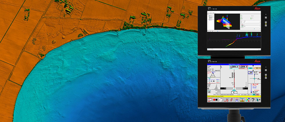
Leica Chiroptera 4X bathymetric data with Leica OC60 screen visualizing objects in near real-time during the flight. (Photo: Hexagon)
Hexagon is partnering with Airbus on a near-real-time airborne bathymetric lidar surveillance system.
Hexagon’s Geosystems division is partnering with Airbus to integrate two Leica Chiroptera 4X bathymetric lidar sensors for maritime surveillance into the C295 MSA, Airbus’ Maritime Surveillance Aircraft.
Hexagon’s new technology enables detection of underwater objects in near real time, a significant innovation in the airborne bathymetry industry, the company said.
The lidar system was developed to meet Airbus’ requirements and will first be implemented in two C295 MSA craft purchased by the Irish Air Corps. The aircraft are due for delivery to Ireland in 2023.
The system’s unique object-detection feature enables real-time lidar data visualization and analysis during flight. Being able to locate the precise position of an object allows operators to preview and analyze information captured below water immediately — a process that previously could take several days.
“When we acquired the C295 MSA, we explored various sensors to be added to our fleet, including bathymetric and topographic LiDAR. Airbus introduced us to the Chiroptera 4X, which now meets all our requirements,” said Stephen Connolly, captain of the Irish Air Corps. “The combined bathymetric and topographic lidar sensor will provide us with more details than ever before. Detecting objects close to real-time and having a clear picture of underwater activities will allow us to report directly to the Mission Support Centre on the ground and act faster to perform our duties more efficiently. The Chiroptera 4X will provide an overall better solution for the coastal maritime domain.”
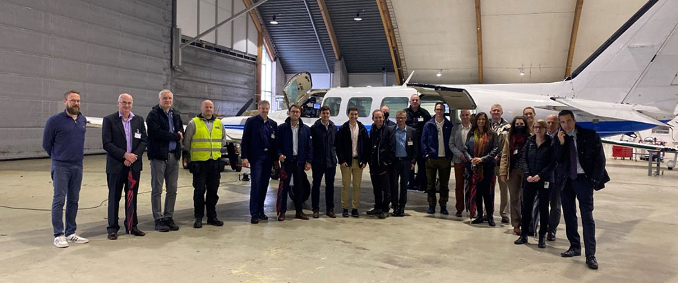
Airbus and Irish Air Corps visited Hexagon’s R&D and production facility in Jönköping, Sweden, in September for the factory acceptance test. (Photo: Hexagon)
SPH Engineering has launched a product designed to conduct bathymetric surveys of inland and coastal water.
The system — an unmanned aerial vehicle (UAV) integrated with an echo sounder — is time- and cost-efficient, the company said. It is suitable for mapping, measuring and inspecting tasks as well as environmental monitoring.
The system allows field workers to collect data with high accuracy quickly. It is easily transported, quickly deployed and twice as cost-efficient as traditional methods.
The UAV/echo sounder system can be operated in hard to reach locations, and unsafe or hazardous environments. Locations not reachable by foot or that are dangerous for a human (steep coasts, mining pits, contaminated waters, terrain obstacles, etc.) as well as waters of ponds, lakes, and canals can be reached by the drone.
“Since autumn 2018 we have been getting bathymetry-related requests,” said Lexey Dobrovolskiy, CTO of SPH Engineering. “Analyzing about 150 inquiries, we have come to the conclusion that a drone-based solution could open a new business opportunity for drone service companies to do bathymetry surveys of coastal and inland water, especially those for industrial needs.
“Compared with a standard approach using a boat or an unmanned surface vehicle, a drone could save a lot for its user,” Dobrovolskiy said. “An echo sounder itself could be integrated into a client’s drone with no need to purchase additional equipment. Moreover, it is small and easy to transport and operate. At the same time, such research method guarantees data accuracy and employee safety.”
SPH Engineering has launched a new product to make bathymetric surveys of inland and coastal water.
The system — an unmanned aerial vehicle (UAV) integrated with an echo sounder — is time- and cost-efficient. It is suitable for mapping, measuring and inspecting tasks as well as environmental monitoring.
The system allows field workers to collect data with high accuracy quickly. It is easily transported, quickly deployed and twice as cost-efficient as traditional methods.
The UAV/echo sounder system can be operated in hard to reach locations, and unsafe or hazardous environments. Locations not reachable by foot or that are dangerous for a human (steep coasts, mining pits, contaminated waters, terrain obstacles, etc.) as well as waters of ponds, lakes, and canals can be reached by the drone.
“Since autumn 2018 we have been getting bathymetry-related requests,” said Lexey Dobrovolskiy, CTO of SPH Engineering. “Analyzing about 150 inquiries, we have come to the conclusion that a drone-based solution could open a new business opportunity for drone service companies to do bathymetry surveys of coastal and inland water, especially those for industrial needs.
“Compared with a standard approach using a boat or an unmanned surface vehicle, a drone could save a lot for its user,” Dobrovolskiy said. “An echo sounder itself could be integrated into a client’s drone with no need to purchase additional equipment. Moreover, it is small and easy to transport and operate. At the same time, such research method guarantees data accuracy and employee safety.”
With more than 80 percent of the world’s oceans unmapped, the deep ocean is one of the last unknown areas on Earth. On May 31, teams with unique exploration solutions were honored with the Shell Ocean Discovery XPRIZE.
XPRIZE is a global competition to advance ocean technologies for rapid, unmanned and high-resolution ocean exploration and discovery. The teams invented new technologies for rapid, unmanned and high-resolution ocean exploration and discovery.
The results were revealed at an awards ceremony hosted at the Oceanographic Museum of Monaco, part of the Oceanographic Institute, Prince Albert I of Monaco Foundation.
The grand prize winner, receiving a total of $4 million, was GEBCO-NF Alumni, an international team based in the United States, while KUROSHIO, from Japan, claimed $1 million as the runner-up.
GEBCO-NF Alumni was led by Rochelle Wigley, Ph.D., and Yulia Zarayskaya, Ph.D. The 14-nation team integrated existing technologies and ocean-mapping experience with a robust and low-cost unmanned surface vessel, the SeaKIT, along with a novel cloud-based data processing system that allows for rapid seabed visualization, to contribute towards comprehensive mapping of the ocean floor by 2030.
Runner-up was KUROSHIO, from Yokosuka, Japan, led by Takeshi Nakatani, Ph.D. The team integrated technologies from their partners to create a surface vessel and software platform that can operate with different autonomous underwater vessels, which increases the versatility of their technology.
Field Testing. To determine winners, the panel of independent judges reviewed data from field testing conducted in Kalamata, Greece, and Ponce, Puerto Rico. In Kalamata, teams had up to 24 hours to map at least 250 square kilometers of the ocean seafloor at five meters horizontal resolution or higher.
The gold-standard high-resolution baseline maps, against which the team maps were judged, were provided by Ocean Infinity and Fugro, while Esri, the global leader in geographic information system (GIS) software and geodatabase management, donated its ArcGIS Online platform for the teams and judges to use.
NOAA Prize. The $1 million National Oceanic and Atmospheric Administration (NOAA) Bonus Prize went to teams for developing technology that could detect a chemical or biological signal underwater and autonomously track it to its source. The award was split between junior high school team Ocean Quest from San Jose, California, which claimed $800,000 as the winner, and Tampa Deep Sea Xplorers, from Florida, taking $200,000 as runner-up.
Additionally, the judges unanimously recommended a $200,000 Moonshot Award for Team Tao from the United Kingdom for its unique approach to seafloor mapping, even though they did not meet the criteria of the competition.
As part of the total $7 million prize purse, four teams opted to compete for the $1 million NOAA Bonus Prize. In a field test in Ponce, Puerto Rico, teams needed to demonstrate that their technology can “sniff out” a specified object in the ocean by first detecting and then tracing a biological or chemical signal to its source.
The judges determined that no single team was able to trace the signal to its source in the timeframe allowed, so the prize was divided among the two teams that came the closest. In 2018, nine finalist teams were awarded an equal share of the first $1 million of the $7 million prize purse, in recognition of their progress-to-date and to support the teams’ continued technological development.
Seabed 2030 and science fiction. As part of its post-prize impact work, XPRIZE announced a partnership with Seabed 2030, a collaborative project between The Nippon Foundation and The General Bathymetric Chart of the Oceans (GEBCO) to inspire the complete mapping of the world’s ocean by 2030 and to compile all bathymetric data into the freely-available GEBCO Ocean Map.
Additionally, and in anticipation of World Oceans Day on June 8th, XPRIZE will launch a science fiction ocean anthology featuring 19 original short stories and artwork set in a future when technology has helped unlock the secrets of the world’s oceans.
TCarta Marine, a global provider of geospatial products and services, has been contracted by the United Kingdom Hydrographic Office (UKHO) to provide a baseline dataset of water depths and seafloor classification around the Republic of Kiribati.
Located in the Pacific Ocean, the island nation is threatened by rising sea levels.
“Most of Kiribati’s islands average less than two meters above sea level at present and the country’s 110,000 inhabitants are among the most vulnerable to the effects of sea level rise and the world’s first potential climate change refugees,” said Kyle Goodrich, TCarta president.
“We expect to map 5,000 square kilometers in total. Our seafloor maps will be used with other geospatial information by the UKHO to recommend policies that will assist the Kiribati in planning for and responding to this situation,” Goodrich said.
TCarta won the open bid for supply of Satellite Derived Bathymetry (SDB) to the UKHO to extract water depth measurements and seafloor classifications, including habitat types, from multispectral satellite imagery.
In this project, TCarta is processing eight-band DigitalGlobe WorldView-2 and -3 data predominantly, as well as four-band WorldView-4 and GeoEye-1 data to measure depths down to 30 meters at a resolution of two meters.
“The Kiribati project highlights the efficiency and cost effectiveness of SDB technology in a geographic area too remote and enormous for traditional marine or airborne survey methods,” Goodrich said.
The Kiribati nation is comprised of 33 atoll islands and multiple reefs spread over an area of the Pacific Ocean nearly the size of the Continental U.S. Multiple new reefs have been discovered by TCarta using this satellite derived approach at the start of this project.
The islands and surrounding environs have not been mapped in their entirety since the late 1800s. Acquiring bathymetric data and habitat classifications using traditional ship-borne sonar or airborne lidar are prohibitively expensive, logistically challenging and come at far higher cost and timeframe than a satellite-based solution.
“We began tasking the DigitalGlobe satellites to capture images in December and will deliver the final products to the UKHO in early March,” said Goodrich, “DigitalGlobe has been a tremendous partner in helping TCarta meet the project deadlines and challenging open ocean conditions with repeat tasking of imagery, collecting more than 300 images in support of the project, despite the loss of WorldView 4.”
TCarta has developed advanced bathymetric measurement technologies using satellite data. Funded by the National Science Foundation SBIR Phase I grant and known as Project Trident, this new technology is being deployed in the Kiribati project to remotely validate the bathymetry results.
Fugro has completed a landmark data acquisition campaign over the Turks and Caicos Islands, marking the first commercial success of its new Rapid Airborne Multibeam Mapping System (RAMMS).
Working under contract to the United Kingdom Hydrographic Office (UKHO), the company acquired more than 7,400 square kilometers of integrated, high-resolution bathymetric, topographic and image data. The resulting deliverables will support updated nautical charts and coastal zone management activities in the region.
Launched in August 2018, RAMMS is a highly efficient, next-generation airborne bathymetric mapping system that uses multibeam laser technology to deliver depth penetration and point densities, the company said. The compact sensor is deployed from small aircraft and can be integrated with other remote sensing technologies for simultaneous collection of multiple complementary datasets.
For the Turks and Caicos project, this approach made it possible to acquire near-shore (bathymetry) and coastal (topography and imagery) data in a single deployment, producing a cost-effective solution and advancing Fugro’s sustainability goals by significantly reducing fuel consumption.
“After years of development, it’s extremely gratifying to operate RAMMS commercially and to demonstrate to clients the value that this cutting-edge technology can bring,” said Mark MacDonald, Fugro Americas Marine Division hydrographic service line director.
He pointed to the massive Turks and Caicos project as an example. “The system’s multibeam lidar capability allowed us to achieve point densities that otherwise would have required vessel-based surveys. With RAMMS, we were able to avoid that additional time and expense, and significantly reduce health and safety exposure.”
Fugro is working on three additional RAMMS projects in the Americas region, one for UKHO in Belize, and two for the Canadian Hydrographic Society, in Quebec and Atlantic Canada. These projects are similar in scope to that of the Turks and Caicos project, combining bathymetry, topography and imagery for maximum value to clients, serving both navigation and coastal applications.
Based on steady interest in RAMMS, Fugro and technology partner Areté Associates are building an additional system to meet anticipated contracting volumes in 2019.
Fugro is also finalizing a cloud-processing capability, which will further improve client delivery by streamlining data review and approvals, and ultimately making data available for download-on-demand.
Additionally, Fugro aims to operate the unmanned aerial vehicle-proven system autonomously in 2019, providing further operational efficiency gains and increasing access to remote project areas.
EOMAP has released a commercial online store for global shallow-water bathymetry derived from satellite data. The store, EOStore Bathymetry, provides access to search for and request high-quality data.
According to EOMAP, satellite-derived bathymetry (SDB) is now established as a valuable tool for the surveying, planning and management of coastal and offshore sites. SDB can provide shallow-water bathymetric data worldwide without the need for a physical presence in the area of interest.
“The EOStore Bathymetry allows every coastal engineer, modeller or surveyor to rapidly access up-to-date shallow water bathymetric data,” said Knut Hartmann, COO of EOMAP. “It enables you to get the bathymetry data you need — even data you could otherwise not get — so you can plan and execute projects accurately, effectively lowering the project risk level.”
EOMAP developed the bathymetry store in response to industry feedback, the company said.
“The demand for bathymetry data in shallow waters is increasing significantly,” Hartmann said. “What industry told us at our first conference on satellite-derived bathymetry, in June 2018, was that they needed to understand the global feasibility of SDB methods and ways to search for and request the data. Thus, we’ve created the EOStore Bathymetry, which allows users to get worldwide shallow-water bathymetry data quickly and easily at a fraction of the price of traditional surveys.”
According to EOMAP, EOStore Bathymetry offers different horizontal spatial resolutions of the bathymetric grid of 2 to 15 meters. This makes it flexible and fit for purpose for surveying, as well as for but also for planning and modeling purposes, the company added.
Under the grant, TCarta will enhance and automate multiple techniques for deriving seafloor depth measurements from optical satellite imagery.
The Project Trident research seeks to transform existing satellite-derived bathymetry (SDB) techniques by using machine learning and computer vision technology to enable accurate depth retrieval in variable water conditions.
If successful, these enhanced bathymetric techniques will improve operations related to oil and gas exploration and production, coastal infrastructure engineering, environmental monitoring and geointelligence activities, the company said.
“Our goal with Project Trident is to expand the geographic scope of SDB in shallow coastal areas,” said Kyle Goodrich, TCarta president. “SDB technology currently derives water depths only in calm, clear waters, which limits its applicability.”
Beta testers sought
TCarta is seeking beta testers for participation in Project Trident research. If you are interested, contact Project Trident Principal Investigator Kyle Goodrich at [email protected] or complete the online Project Trident survey.
TCarta won the grant for Project Trident in partnership with jOmegak of San Carlos, California, and DigitalGlobe of Westminster, Colorado, in Phase 1 of the NSF Small Business Innovation Research program.
The one-year research project will be carried out at the TCarta facility in Denver.
In 2014, TCarta successfully commercialized a proprietary technique for digitally extracting water depth measurements down to 20 meters from high-resolution DigitalGlobe WorldView satellite imagery.
The SDB products became popular with organizations operating in shallow coastal waters because the technology is more cost-effective and timely than traditional airborne and ship-borne bathymetric methods — with no adverse effects on the environment, the company added.
“In the current SDB process, we use manual stereo photogrammetry methods to measure seafloor ground control points in digital satellite imagery, but this is extremely time consuming,” said Goodrich. “We are developing an automated photogrammetric process to extract a greater number of ground truth points from high-resolution WorldView imagery.”
Project Trident aims to integrate wave kinematics, a technique patented by jOmegak to calculate water depths in shallow waters by analyzing the patterns and speed of waves detected in satellite imagery. Wave kinematics has been applied successfully using Sentinel-2 and WorldView satellite imagery.
“Thanks to the NSF grant, we are taking a giant leap forward on TCarta satellite-derived bathymetry methodologies and aim to exponentially accelerate them with the latest in machine learning and computer vision technologies,” said Goodrich.
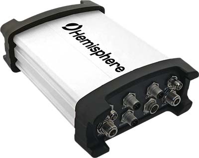
Hemisphere GNSS has introduced the Vector V1000 GNSS receiver for precision marine applications. The V1000 provides high-accuracy heading, position, pitch, roll and heave data.
The company made the announcement at the Oceanology International conference being held this week in London, U.K.
The V1000 supports multi-frequency GPS, GLONASS, BeiDou, Galileo, QZSS and IRNSS (with future firmware upgrade and activation) for simultaneous satellite tracking. The receiver is powered by Hemisphere’s Athena real-time kinematic (RTK) engine and is Atlas L-band capable.
The new V1000 is designed for professional marine applications, such as hydrographic and bathymetric surveys, dredging, oil platform positioning, buoys and other applications that demand the highest level 3D positioning accuracies. Based on Hemisphere’s Eclipse Vector technology, the V1000 uses the most accurate differential corrections including RTK and Atlas L-band.
The V1000 is Hemisphere’s flagship receiver, with an integrated display, that can be conveniently installed near the operator. The two antennas can be installed at user-specified separation, providing valuable flexibility in terms of install locations and desired heading accuracy.
The V1000 has heading accuracy of better than 0.01 degree when using a 10-meter antenna separation. With CAN, serial, Bluetooth, Wi-Fi and Ethernet support and flexible installation, the all-new rugged enclosure gives the V1000 the advantage of working reliably in harsh environments, the company said.
Fugro is supporting NF-GEBCO Seabed 2030, a global initiative to produce a definitive, high-resolution bathymetric map of the entire world’s ocean floor by the year 2030.
The initiative is being facilitated by the General Bathymetric Chart of the Oceans (GEBCO) project in partnership with The Nippon Foundation as a means to inform global policy, improve sustainable use and advance scientific research.
Less than 20 percent of the world’s oceans are mapped using modern survey techniques. Accurate seabed measurements (bathymetry) are important for numerous government, scientific and industry applications, according to Fugro.
“As the world’s largest offshore survey company, Fugro is in a position to help close this data gap, and we are committed to doing our part through the Seabed 2030 project,” said David Millar, Fugro’s government accounts director in the Americas.
One of the primary ways Fugro is supporting Seabed 2030 is through crowdsourced bathymetry data contributions.
In 2017 the company devised a methodology for collecting valuable high-resolution bathymetry datasets while its vessels are transiting between survey projects. The approach is made possible through Fugro’s Office Assisted Remote Services (OARS), its proprietary technology that enables safe and efficient data acquisition without the need for dedicated survey staff on board.
In this way, valuable data can be collected from transiting vessels with minimal effect on Fugro’s standard operating procedures.
In 2017, Fugro deployed its in-transit data collection methodology on two survey vessels, delivering approximately 65,000 square kilometers of crowdsourced bathymetry data to GEBCO.
The company has recently expanded that collection capacity to include four survey vessels and intends eventually to incorporate the approach across its entire global survey fleet to make an increasingly significant impact on the Seabed 2030 program.
“Fugro has displayed exemplary corporate leadership by sharing transit data from two of its survey vessels,” acknowledged Seabed 2030 Project Director Satinder Bindra. “In the coming months we look forward to receiving more transit data from all its survey vessels, which we believe will serve as a shining example to others in the industry and play an important role in helping us map the entire ocean floor for the benefit of humanity by 2030.”
Along with its own data contributions, Fugro is working with its clients to investigate how their datasets (existing and planned) may be incorporated into the Seabed 2030 program. In some instances, data sharing is straightforward, but in many others, datasets contain sensitive information.
Reducing the data resolution to a suitable degree and delaying the release of datasets until an acceptable amount of time has passed can mitigate these sensitivities and ensure the integrity of client-owned data.
The company is also helping to establish a workflow for integrating third-party datasets into the overall Seabed 2030 project database. The workflow will address such things as data formats and metadata standards, with the goal of simplifying and accelerating the rate of crowdsourced contributions and data sharing arrangements.
“We are proud to continue our support of the Seabed 2030 programme and to lead industry participation in this way,” Millar said. “As an appreciable portion of our work is ocean related, Seabed 2030 provides a perfect opportunity for us to contribute to global society and practice good ocean stewardship.”
The Bathymetrics Data Portal allows users to search, purchase and automatically download water-depth information directly from an online store to their computer.
The Bathymetrics Data Portal is a combined offering by DHI, experts in water environments; TCarta, a global provider of marine geospatial products; and powered by DigitalGlobe, provider of high-resolution satellite imagery.
The dedicated commercial bathymetry portal offers continuously expanding 2m Bathymetry data in shallow water areas and a global database of interpolated 90m bathymetry. The portal allows users to search for data in their area of interest and purchase what they need. Data is priced by the square kilometer; the customer pays online with credit card and can download the data shortly after.
“We are very excited about this launch, as we have made direct access to off-the-shelf bathymetry data very easy and intuitive,” said DHI COO, Jacob Høst-Madsen. “The shop marks an important milestone in our continued quest to develop and offer high quality, affordable bathymetry data”
Bathymetric products are used extensively by organizations involved in energy infrastructure development, port construction, environmental monitoring, aquaculture planning and hydrodynamic modeling.
“The per-kilometer pricing model puts high-quality bathymetric data within easy reach of organizations of any size in all industries,” said TCarta CEO David Critchley. “One-person engineering shops, academic entities and other organizations with limited budgets can now engage in complex offshore projects.”
The portal is constantly being updated with new and improved data, providing users with the best available bathymetric information around the world.
TCarta Marine, a global provider of marine geospatial products, will unveil two new offshore data offerings at the 2017 Esri Petroleum GIS Conference in Houston — the Gulf of Mexico Marine Basemap Plus service and 2-meter Satellite Derived Bathymetry dataset.
The Marine Basemap Plus is a streaming data service that delivers up-to-date value-added marine layers directly into Esri ArcGIS on a subscription basis.
The 2-meter Bathymetry product is an off-the-shelf shallow water, coastal zone bathymetric dataset derived from high-resolution satellite imagery.
Both products will be demonstrated by TCarta Marine in booth #403 at the Esri Petroleum Conference being held April 12-13, in Houston’s George R. Brown Convention Center.
“The Marine Basemap service covering the entire Gulf of Mexico is available now,” said TCarta Marine President Kyle Goodrich. “Datasets for additional marine regions around the world will be added this year with the North Sea available this summer.”
The streaming data service was developed with the oil and gas industry in mind, allowing customers to choose from two subscription tiers for the Gulf of Mexico. The GoM Marine Basemap is a tiled map service intended to provide users with an informative and aesthetically pleasing backdrop streamed into the desktop GIS environment. The Basemap is a scale-dependent display of a stylized bathymetry image with labeled contour lines and marine feature names
The Marine Basemap Plus incorporates best-available resolution bathymetry grids, contour lines and other valuable data for modeling, analysis and derivative work. The entire gulf is covered at 90-meter resolution while many areas have been mapped at 30-meters, with higher resolution data to be added.
“Marine Basemap Plus will appeal to oil and gas companies of all sizes because the streaming data is extremely affordable and updated constantly through the subscription process,” said Goodrich. “The GIS manager at an energy company will never have to worry about obtaining the most recent or highest quality offshore data because it will be downloaded automatically.”
The Gulf of Mexico Marine Basemap Plus also includes information enhanced from authoritative sources such as the National Oceanic and Atmospheric Association (NOAA), National Ocean Service, Department of Energy and Bureau of Energy Management. The five main value-added layers relate to:
Navigation – Seafloor elevation data including dredged channels and shipping lanes
Geology – Natural features and seismic anomalies
Lease Blocks – Active leases, well, and pipeline information
Habitat – Reefs, grasses, corals and other marine ecosystems
Shoreline – Vector derived from lidar and satellite imagery
Also making its U.S. debut at the Esri Petroleum show will be the 2-meter Satellite Derived Bathymetry offering developed by TCarta Marine, DHI and DigitalGlobe with funding from the European Space Agency. This is an off-the-shelf version of a custom product introduced in 2011 by Proteus Geo, which merged with TCarta Marine this year. It will eventually be a global marine dataset.
To create this product, accurate seafloor depths are extracted by DHI using a primary production technique before TCarta Marine ensures that all data undergoes a rigorous quality control procedure. All depths are derived from eight-band multispectral imagery captured by DigitalGlobe’s high-resolution WorldView satellites, the commercial imaging constellation.
“This process derives bathymetric measurements at 2-meter resolution to an average depth of 20 meters in the near-shore coastal zone, where environmental conditions allow,” Goodrich said. “The 2-meter product will be sold by the square kilometer, which means clients only pay for the data they need, making this a very cost-effective product.”
The off-the-shelf 2-meter product covering the Arabian Gulf is available for purchase now, with the Red Sea planned for completion by later this year. By mid-2017, TCarta Marine will make the 2-meter products available for instant searching, purchasing and downloading through an online portal called Bathymetrics.
The Gulf of Mexico Marine Basemap Plus and 2-meter Bathymetric products can be ordered through [email protected].