Tag: battlefield

  • Orolia selected by Raytheon to support US Missile Defense System

    Orolia selected by Raytheon to support US Missile Defense System

    Orolia, through its Orolia Government Systems business, has been selected by Raytheon Missiles & Defense to support the U.S. Lower Tier Air and Missile Defense Sensor (LTAMDS) radar program with its low SWaP (size, weight and power), rugged time and frequency system.

    Defeating hypersonic weapons

    An artist's rendering of the Lower Tier Air and Missile Defense Sensor (LTAMDS), a next-generation radar meant to help defeat advanced threats like hypersonic weapons. (Image: Raytheon/Orolia)
    An artist’s rendering of the Lower Tier Air and Missile Defense Sensor (LTAMDS), a next-generation radar meant to help defeat advanced threats like hypersonic weapons. (Image: Raytheon/Orolia)

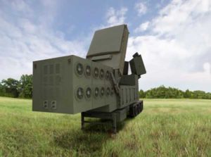
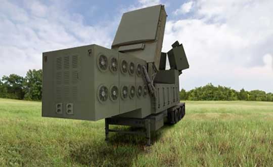
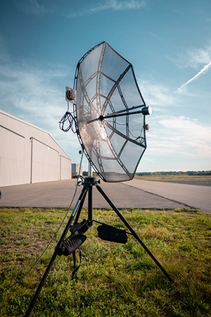
    The LTAMDS system — an advanced air and missile defense radar — will help the U.S. Army defeat advanced threats, including hypersonic weapons. It is a radar designed to defeat advanced and next-generation threats including hypersonic weapons, or those that fly faster than a mile a second.

    LTAMDS has three antenna arrays — a primary array on the front, and two secondary arrays on the back. They work together, detecting and engaging multiple threats from any direction at the same time. This results in a battlefield without blind spots, according to Raytheon.

    LTAMDS’ primary array is about the same size as the array for the Patriot Air and Missile Defense System, but it has more than twice the power. It is designed for the U.S. Army’s Integrated Air and Missile Defense system, but it will also preserve existing military customers’ investment in the Patriot system.

    Raytheon Missiles & Defense was selected by the United States Army in October 2019 to provide the next-generation LTAMDS.

    Timing from Orolia

    Orolia was chosen for the LTAMDS program based on its core expertise in resilient timing and configurable ruggedized PNT systems for challenging environments, together with its proven track record of successfully delivering time and frequency platforms for other Raytheon Programs of Record.

    Orolia was the first company to receive approval for a time and frequency reference system on the Defense Information Systems Agency (DISA) Department of Defense Information Network (DoDIN) Approved Products List for network interoperability, with its flagship SecureSync system.

    “Ultra-precise mission timing and sync technology are fundamental building blocks for the Resilient PNT systems that warfighters rely on for continuous operations in contested environments,” said Hironori Sasaki, president of Orolia Defense & Security. “We are proud to be a Raytheon Missiles & Defense partner on LTAMDS and other programs that utilize GPS signals for timing, frequency and network synchronization across critical military systems.”

    From critical timing solutions to GPS/GNSS simulation, interference detection, and mitigation, Orolia is an industry leader in end-to-end NAVWAR and Resilient PNT solutions to protect, augment and strengthen military systems for GPS-denied environments.

    Orolia Defense & Security provides resilient PNT solutions and custom engineering services to U.S. government agencies, defense organizations, and their contractors, and is authorized to work on the full spectrum of U.S. government classified and unclassified projects.

  • UK tests tracking UGVs in military exercise

    UK tests tracking UGVs in military exercise

    In December 2018 near Salisbury, England, four Milrem Robotics’ and QinetiQ TITAN unmanned ground vehicles (UGVs) were put through three weeks of rigorous tests by British troops during the Army Warfighting Experiment 2018 (AWE18).

    The goal was to determine how new unmanned technologies can enhance soldier’s survivability and effectiveness on the modern battlefield.

    The modular base can be adapted for various missions, including casualty retrieval. (Photo: Milrem Robotics)
    The modular base can be adapted for various missions, including casualty retrieval. (Photo: Milrem Robotics)

    The test was conducted in three phases: conduct combat operations without the benefit of new technologies; conduct combat operations using new technologies but without changing tactics; and, lastly, conduct combat operations using new technologies and adapting tactics according to the capability that the new technology provides.

    The UGVs were used in a number of different roles with missions conducted in urban, open and forested terrain.

    In remote-control mode, a command-and-control station allows the operator to receive real-time sensor data from the UGV and to transmit command data to the vehicle through a tactical data link. Various third-party sensor packages can be installed.

    Of the four Milrem UGVs, two were deployed by Milrem Robotics and two by QinetiQ. The Milrem-fielded systems included one configured as a casualty evacuation and logistical support unit and a second unit equipped with a tethered multi-rotor drone pod provided by Threod Systems.

    One of the four UGVs was TITAN Strike, a prototype system carrying a Kongsberg remote weapon station, fully controlled by a remote operator and using QinetiQ’s Pointer system as a means of integrating the capability with dismounted infantry.

    The second system, TITAN Sentry, also enabled with Pointer, featured a Hensoldt-provided sensor suite including electro-optical and thermal-imaging cameras and a battlefield radar.

  • GPS III finally aloft, benefits on the way

    SpaceX’s Falcon 9 rocket orbited the first GPS III satellite on Dec. 23, 2018. (Photo: SpaceX)
    SpaceX’s Falcon 9 rocket orbited the first GPS III satellite on Dec. 23, 2018. (Photo: SpaceX)

    On December 23, the first GPS III satellite entered an orbit around Earth, after a five-day delay. This first of a new breed of GPS satellite also experienced a four-year delay, with its original launch scheduled for 2014.

    While the system has experienced more than its share of problems, at the start of a new year I want to focus on the benefits to come.

    Few of us realized how much our lives would change when the first GPS satellite was launched in 1978. GPS III could bring about a similar trajectory of changes. Civilians can expect a more reliable and accurate service. The smartphone message “searching for signal” could become a dim memory.

    GPS III signals will be three times more accurate than the current GPS Block II models. The navigation payload has more than three times reduction in range error and up to eight times increase in power — its signals should be much easier to pick up under tree canopy, within urban canyons and inside buildings.

    GPS III also has four civilian signals. The L1C signal is interoperable with international GNSS, meaning users can receive signals from any country’s satellites. Also, using two civilian signals means GPS III can directly detect and correct ionospheric errors.

    In addition to a standard wide-angle antenna for broad coverage, the GPS III satellites include a high-gain directional antenna that will operate with 100 times (+20 dB) the power of the wide-angle antenna, and will be exclusively for use with M-code (military) transmissions. This directional antenna’s spot beam covers an area 120 miles at high power— boosting the power of military GPS signals by 100 times in specific regions, making military GPS even harder to jam.

    These advantages may not reach the battlefield for a decade. The new constellation will take time to build. The GPS III constellation is projected to be fully capable in June 2023, when 10 Block IIIA satellites are expected to be in orbit. Ten follow-on satellites are planned to be placed into orbit from 2026 to 2034.

    Back here on Earth, equipment makers will need time to develop and supply warfighters with military GPS user equipment (MGUE) that can take advantage of all that GPS III has to offer.

  • Enhanced Stinger missile counters enemy UAVs

    Enhanced Stinger missile counters enemy UAVs

    U.S. Army completes qualification testing for new Stinger missile proximity fuze.

    The new proximity fuze enables the Stinger missile to destroy a wider array of battlefield threats such as enemy unmanned aircraft systems. (Photo: U.S. Army)
    The new proximity fuze enables the Stinger missile to destroy a wider array of battlefield threats such as enemy unmanned aircraft systems. (Photo: U.S. Army)

    The U.S. Army has completed qualification testing for a new proximity fuze that significantly enhances the combat-proven Stinger missile produced by Raytheon Company.

    The proximity fuze detonates the warhead if the missile passes within a certain radius of the target, creating a cloud of shrapnel that eliminates the target.

    During testing at Eglin Air Force Base in Florida in April 2017, the upgraded weapon system scored a perfect 100 percent hit rate against a variety of targets. The missiles were shoulder- and vehicle-launched.

    The new proximity fuze enables the lightweight, self-contained air defense system to destroy a wider array of battlefield threats such as enemy unmanned aircraft systems by detonating the missile’s warhead near the target, while maintaining its hit-to-kill capability.

    “Equipped with a new proximity fuze, Stinger is an affordable, near-term and proven solution for countering emerging threats in the battlespace,” said Kim Ernzen, Raytheon Land Warfare Systems vice president. “Together with the Army, we are putting the most capable Stinger yet into the hands of our brave men and women on the battlefield.”

    https://youtu.be/h75hxN-hcMQ

    With qualification testing complete, the Army can move toward a near-term fielding under an Urgent Materiel Release. Plans call for the new proximity fuze to be integrated into Stinger missiles as part of a Service Life Extension Program to be conducted at the Army’s ammunition plant in McAlester, Oklahoma.

    Combat proven, the Stinger missile has more than 270 fixed- and rotary-wing intercepts to its credit. It’s deployed in more than 18 nations and with all four U.S. military services. The weapon can be rapidly deployed by ground troops and on military platforms, and has been integrated for use on the Apache Attack Helicopter.

  • Persistent Systems provides drone tracking for battlefields

    Persistent Systems LLC has introduced the Auto-Tracking Antenna System, a new portable ground-to-air antenna that operates on the Wave Relay mobile ad hoc network (MANET).

    Designed to incorporate aircraft into the MANET, the Auto-Tracking Antenna System is a complete portable ground-to-air system for tracking aircraft, including drones. Army, Navy and foreign customers can use it for better airborne communications relay and full-motion video camera/sensor data transmission, Persistent said.

    Photo: Persistent Systems
    Photo: Persistent Systems

    “The Auto-Tracking Antenna System represents a major step towards achieving the vision of a truly networked battlefield,” said Herb Rubens, CEO of Persistent Systems. “The tracking antenna rotates to follow air assets, keeping them connected to the MANET. “The air platforms orbit over our users on the ground, extending the MANET bubble and keeping soldiers connected to the enterprise. High throughput, low latency connectivity empowers the warfighter and decreases the dependence on SATCOM, which both reduces cost and increases network availability.”

    Designed for ease-of-use, quick assembly and portability, the Auto-Tracking Antenna System can be assembled and deployed in less than 15 minutes, the company added.

    The portable and lightweight design is completely collapsible, with the main five-foot parabolic dish breaking down into eight individual petals.

    The entire system fits into most standard-sized SUVs for easy transport and compact storage.

    Photo: Persistent Systems

    Mimicking the MPU5’s modular RF structure, the Auto-Tracking Antenna System has interchangeable S-band, L-band and C-band MIMO feeds that allow it to cover all frequencies where Persistent’s five radio modules operate.

    The antenna feeds twist-lock into place for quick and simple installation. An Automatic Heading System enables the tracking antenna to self-calibrate prior to operation for greater precision and less than one-degree pointing accuracy.

    “Our customers require a system that is simple to put together, turn on, and works,” said Louis Sutherland, vice president of business development at Persistent Systems. “They want to extend the Wave Relay MANET out to aircraft and achieve high data-rates and reliable HD video transmission. The Auto-Tracking Antenna System truly delivers.”

    The large parabolic dish enables video streaming out to distances of 130 miles (over 200 kilometers) while maintaining high throughput and strong signal strength.

    Photo: Persistent Systems
    Photo: Persistent Systems

    Combining the precisely aimed tracking system with the MPU5 radio and Wave Relay MANET achieves optimal connectivity and reliable communications for manned and unmanned aircraft to communicate further than ever before.

    The antenna is IP67 rated and built to endure harsh environments and weather, so it can be setup and left out for as long as the mission requires.

  • Raytheon contracted to demonstrate Army mobile intelligence platform

    FoXTEN software product gives soldiers access to real-time intelligence data in the field.

    Raytheon Company has been awarded a U.S. Army contract to demonstrate the company’s commercially available mobile intelligence platform that will allow soldiers to quickly collect and access information on the battlefield.

    Raytheon’s commercial laptop-based platform, called the FoXTEN, may be considered as a future mobile component of the Army’s Distributed Common Ground System (DCGS).

    FoXTEN provides mapping functions in both MIL-STD-2525B and MIL-STD-2525C symbology.

    DCGS is an intelligence, surveillance and reconnaissance system that enables deployed soldiers to collect, process and display intelligence information from a variety of sources and sensors. The Army is upgrading its existing DCGS system with a series of new components and capabilities, including the mobile platform.

    “Our soldiers need real-time access to intelligence and surveillance data, and FoXTEN is designed to get that information to and from the most remote edges of the battlefield,” said Todd Probert, vice president of mission support and modernization at Raytheon Intelligence, Information and Services. “We’ll be bringing our deep experience integrating the best commercial software into a system our soldiers can trust to keep them constantly aware of threats and give them the advantage they need to win on any battlefield.”

    Under the contract awarded by the U.S. Army Contracting Command, Raytheon will demonstrate the company’s FoXTEN software product, which can be loaded onto a commercially procured laptop and easily deployed and used by soldiers operating in the field.

    FoXTEN quickly connects warfighters to intelligence from various sources, giving them the real-time information they need to make mission decisions across all battle domains. FoXTEN, when loaded onto a laptop, is lightweight, requires little power and can operate at low-transmission speeds.

    “Our system is intuitive, easy to use and only takes eight hours of training compared to the current system,” said Probert. “It’s also completely open, allowing the Army to integrate new capabilities from any developer. The system is designed from the ground up to be easily upgraded so our soldiers always have the best technology and intelligence in their hands.”

    The Army will conduct a series of operational tests of the FoXTEN software over the next year before making a final procurement decision.

  • U.S. Army solicits PNT solutions for warfighters

    U.S. Army solicits PNT solutions for warfighters

    The U.S. Army is soliciting proposals for research, development, design and testing that directly supports battlefield technologies in the area of positioning, navigation and timing (PNT).

    Broad Agency Announcement (BAA W56KGU-18-R-PN22) was issued by the U.S. Army’s Communications-Electronics Research, Development and Engineering Center (CERDEC) on Nov. 24 through FedBizOpps.gov.

    CERDEC — based at the Aberdeen Proving Ground in Maryland — aims to discover technical approaches to improve and enhance current and future land warrior capabilities, flexibility and responsiveness in line with its strategic vision for enhancing warfighter capabilities to operate in both symmetric and unsymmetrical environments.

    GPS-denied environments. “The goal is to support CERDECs Strategic Thrust for PNT by providing technical and operational capabilities that enables the soldier to continue their operations in hostile RF and GPS-denied environments,” reads the BAA. “Proposed technical approaches may apply to operations both before and after the cessation of hostilities.

    “This announcement emphasizes approaches that address the very different challenges presented by urban fighting and dramatically enhance warfighter capabilities, for example, the ability to interact, maneuver and operate under a time constrained environment. These changes should generally result in lower casualties, lower collateral damage, and the effective use of combat power.

    “The specific topics of interest revolve around the research and development of technologies may provide revolutionary improvements to the entire spectrum of PNT.”

    Soldiers with 18th Military Police Brigade, assault opposing enemy threats during an Urban Operations training at the 7th Army Training Command’s Grafenwoehr Training Area, Germany, Oct. 20, 2017. (U.S. Army photo by Spc. Javon Spence)

    CERDEC’s plan is to support multiple and potentially multiphase efforts that pursue the design, development, integration and demonstration of critical and enabling technology and system attributes pertaining to PNT. Proposed efforts will primarily be of service and material with aims at resolving technical barriers.

    Proposals. Proposals submitted should range in scope from study and analysis type work with limited data and deliverables, to larger efforts for component developments, techniques and demonstrations with breadboard or prototype-style deliverables.

    The contracts are expected to be cost-plus-fixed-fee, but can be negotiated.

  • Orolia’s VersaPNT helps soldiers navigate battlefields without GPS

    Orolia’s VersaPNT helps soldiers navigate battlefields without GPS

    Orolia, through its Spectracom brand, has launched VersaPNT. VersaPNT provides virtually failsafe battlefield navigation, even in GPS-denied environments, to protect critical networks with Assured PNT technology, the company said.

    The new, ground, air or sea vehicle-mounted solution is designed for military environments, with a ruggedized, compact, low-power and lightweight form factor.

    Today, military vehicles are portable networks, providing seamless connections with U.S. headquarters, regional command posts and individual soldiers. Remote areas are challenging environments for military networks, and enemy forces are jamming, spoofing and disrupting operations.

    “VersaPNT provides continuous mission assurance and C4ISR support, even in hostile environments,” said Rohit Braggs, Orolia vice president, PNT networks and sources. “This innovative technology solution protects critical networks for complex military and homeland security land, air and sea operations.”

    Every minute counts on the battlefield, and VersaPNT provides critical decision support with real-time situational awareness to facilitate a rapid response, according to the company. This lifesaving technology can also help keep soldiers and civilians out of harm’s way, while ensuring continuous tracking of friendly and enemy forces.

    VersaPNT provides essential command and control, navigation, communication and electronic intelligence support for U.S. and allied military, homeland security, first responder, civilian agency, special operations and intelligence missions.

    Demonstrations are available at the AUSA Annual Meeting, Orolia Booth #2944.

  • Boomerang system locates gunfire on the battlefield

    Boomerang system locates gunfire on the battlefield

    Surrounding sounds may not be a common way of determining location. But on the battlefield, warfighters need to know the direction of gunshots to enable a proper response.

    Weighing 12 ounces, the Boomerang Warrior-X by Raytheon BBN Technologies provides immediate hostile fire location awareness to individual soldiers and gives unit leaders shooter grid coordinates, according to the company. These situational awareness enhancements improve coordinated team responses to hostile fire.

    Incoming shot announcements are transmitted to a built-in speaker or an earpiece while a lightweight display provides range and azimuth of the shooter position. As the soldier moves, the system compensates for the soldier’s motion and continually updates the threat’s location on a wrist display.

    The Boomerang Warrior X system.

    This summer, an undisclosed Gulf nation has awarded a direct commercial sales contract to Raytheon BBN Technologies valued at more than $10 million for the delivery of 2,000 Boomerang Warrior-X systems during the next 12 months.

    “This technology is a proven life saver on the battlefield,” said Ed Campbell, president of Raytheon BBN Technologies. “Boomerang delivers the best performance of any available shooter detection system today at the lowest cost.”

    Raytheon BBN Technologies is a wholly owned subsidiary of Raytheon Company.

  • Sky-Watch Partners with General Dynamics on UAVs for Defense

    Sky-Watch Partners with General Dynamics on UAVs for Defense

    Artist's concept of the proposed Airborne Swarm Protection Shield by GDELS and Sky-Watch.
    Artist’s concept of the proposed Airborne Swarm Protection Shield over a GDELS armored vehicle (image courtesy of Sky-Watch).

    General Dynamics European Land Systems (GDELS) has signed a Memorandum of Interest (MOI) with Danish UAV company Sky-Watch in Støvring, which allows the two companies to explore potential areas of cooperation within next-generation applications of UAV technology in the battlefield.

    “Sky-Watch is constantly striving to be at the forefront of the rapidly developing UAV technology,” said Michael Messerschmidt, Sky-Watch chief business development officer. “We offer our vast accumulated know-how within sensor fusion to our partners, in the pursuit of finding new ways to solve tomorrow’s challenges. We constantly rethink and redefine the value proposition, of our own as well as our partners’ ideas and concepts and I believe that we can identify some very exiting avenues of cooperation with General Dynamics European Land Systems.”

    Sky-Watch offers the Huginn X1 multi-purpose Quadrotor UAV deployed all over the world and is developing the Muninn X1, a next-generation fixed-Wing VTOL UAV. The future of UAVs in the battlefield will be explored by Sky-Watch Labs, the research and development arm of Sky-Watch, in cooperation with partners such as the Technical University of Denmark on a variety of projects.

    With regard to the acquisition of new Armored Personnel Carriers (APC) for the Danish Army, General Dynamics European Land Systems is prepared to take its partnerships with Danish industry to the next level and explore business in adjacent markets like the one of Sky-Watch. GDELS has signed Industry Cooperation agreements with 40 Danish companies of all sizes across the country, and has already defined projects in excess of 3,7  billion  kroner covering all of the technology areas defined in the Danish Government’s Defence industry strategy.

    “Throughout the past 20 years, GDELS Industry Cooperation program has been one of the catalysts for the development of the Danish defence industry. We have executed projects of almost 1,7 billion kroner with the industry, which has helped to contribute to the development of new products and technologies in a variety of companies. By engaging with an innovative and creative company such as Sky-Watch, we help plant the seed for the future of the Danish defence industry,” said Jens Bauer, GDELS Senior Director International Business & Services, responsible for Industrial Participation.

    GDELS’s Industry Cooperation plan for the APC program is based on 20 years of experience and partnership with Danish industry. The program expands relationships beyond production and sustainment contracts to also include research & development projects, which will lay the foundation for growth in the Danish Defence industry for decades to come.