Tag: Blue Marble

  • Launchpad: GNSS receivers, sensors, software

    Launchpad: GNSS receivers, sensors, software

    A roundup of recent products in the GNSS and inertial positioning industry from the September 2020 issue of GPS World magazine.


    OEM

    Inertial sensors

    Includes four models

    Photo: SGB Systems
    Photo: SGB Systems

    The third-generation Ellipse series has a 64-bit architecture, allowing high-precision signal processing. All of the INS/GNSS devices now embed a dual-frequency, quad-constellation GNSS receiver for centimetric position and higher orientation accuracy. The Ellipse-A is a motion sensor; Ellipse-E provides navigation with an external GNSS receiver; Ellipse-N is a single-antenna RTK GNSS/INS; and Ellipse-D is a dual-antenna RTK GNSS/INS. With its new 64-bit architecture, the third-generation Ellipse series enables the use of high-precision algorithms and technology used in high-end inertial systems such as rejection filters and FIR filtering.

    SBG Systems, sbg-systems.com

    Assured Reference

    Protects critical infrastructure

    Photo: Jackson Labs
    Photo: Jackson Labs

    The PNT-6220 Assured Reference combines low-Earth-orbit (LEO) signals, GNSS, terrestrial, wireline and atomic clock services in one small solution for critical infrastructure applications. The PNT-6220 seamlessly combines concurrent L1, L2, L3 and L5 GNSS reception with a LEO-based Satellite Time and Location (STL) timing receiver. It also includes terrestrial receivers and PTP/IEEE-1588 edge grandmaster and PTP/IEEE-1588-slave capability. It provides assured PNT for critical infrastructure applications such as those described in the directives of Presidential Executive Order 13905. It can serve as a timing reference for 5G equipment, an ePRTC-capable reference, or a high-performance disciplined reference that supports PTP/IEEE-1588, STL, RF distribution and multi-frequency GNSS capability. The PNT-6220 can automatically select the most optimal UTC reference input and switch over among its numerous reference inputs if one or more are jammed or spoofed, as well as average several references for additional stability and accuracy.

    Jackson Labs Technologies, jackson-labs.com

    GNSS Receiver

    Integrates correction service

    Photo: Septentrio
    Photo: Septentrio

    The AsteRx-m2 Sx OEM board provides a GPS/GNSS receiver with always-on sub-decimeter accuracy without the need for additional correction service subscriptions. GNSS corrections are automatically streamed to the receiver. The integration enables plug-and-play positioning with high accuracy available out of the box. The AsteRx-m2 Sx is an efficient positioning solution for small robots, aerial drones and automation applications. Advanced anti-jamming technology AIM+ ensures robust and reliable operation in challenging environments, even in the presence of RF interference.

    Septentrio, septentrio.com
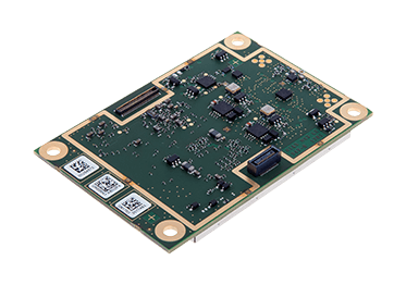
    Inertial navigation

    Board set for system integrators

    Photo: OxTS
    Photo: OxTS

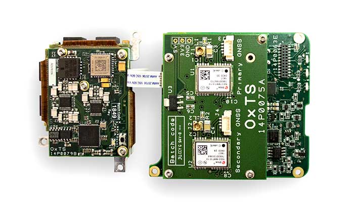
    The xOEM v3 inertial navigation system includes the architecture from the company’s IP65-encased xNAV v3 as well as a full range of software interfaces, providing integrators maximum configuration flexibility, real-time monitoring, post-processing and analysis. Software interfaces can be customized using the OxTS NAVsuite. Plugins can be created using the company’s NAVsdk, allowing the xOEM v3’s software to be easily packaged and included as part of a product.The high-grade MEMS inertial sensors and real-time kinematic (RTK)-capable GNSS receiver within the xOEM v3 board set deliver high performance capabilities. The board set provides 0.1° heading accuracy, 0.05° pitch/roll accuracy and 2 cm global position accuracy. The board set is compact at 150 grams, which enables manufacturers to seamlessly integrate and build a high-performance INS into their products, such as commercial mapping applications on land and in the air. Its light weight means more payload capacity for other critical components. An add-on lidar georeferencing software package is also available with a sophisticated boresight calibration tool.

    Oxford Technical Solutions, oxts.com


    SURVEYING & MAPPING

    GNSS receiver

    Designed to supplement M300 Pro

    Photo: ComNav
    Photo: ComNav

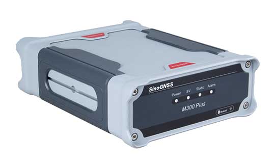
    The M300 Plus GNSS receiver is designed to supplement the company’s M300 Pro, which is aimed at clients who need a more economical version for their CORS networks. The M300 Plus is also designed for monitoring projects and other applications. By using a powerful, adaptive detecting and canceling technology, the M300 Plus provides enhanced anti-jamming capability, which is critical for a reference station providing reliable GNSS data. Its built-in web server provides remote control of receiver configuration, status, firmware update and data download. It uses a 4G module as an internet backup, enhancing the stability of data connections.

    ComNav Technology, comnavtech.com

    3D lidar

    For security and smart city markets

    Photo: Quanergy
    Photo: Quanergy

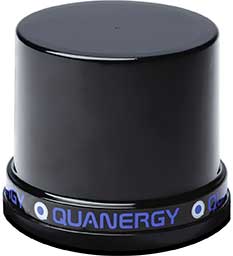
    The MQ-8 family — 3D lidar sensors and perception software — are part of Quanergy’s Flow Management platform. Designed with a new smart beam configuration, the MQ-8 solution delivers up to 140 meters of continuous tracking range, enabling up to 15,000 m2 of coverage with a single sensor. It is suitable for flow management applications such as security, smart city, social distancing and smart space industries.

    Quanergy Systems, quanergy.com

    3D building layer

    More than 350 million buildings

    Screenshot: Cesium
    Screenshot: Cesium

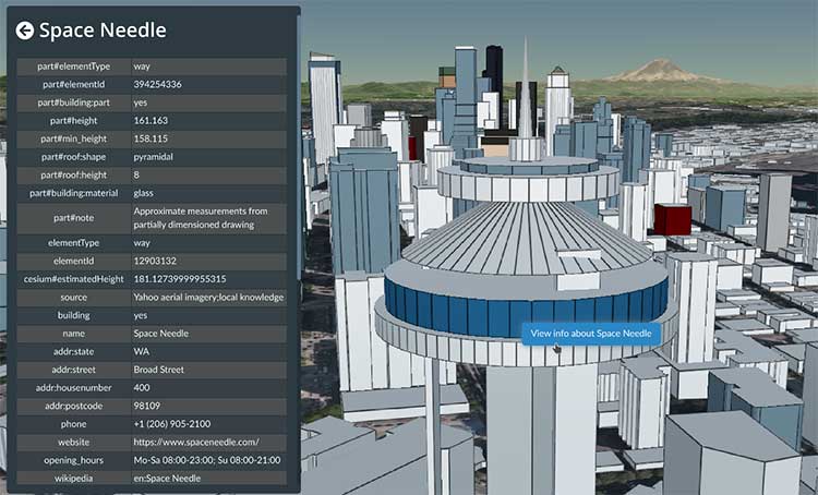
    Cesium OSM Buildings expands the company’s suite of Global Base Layers including worldwide terrain, aerial imagery and streetmaps already available. With the new layer, 3D buildings can be visualized, styled and analyzed in an efficient and interoperable manner using 3D Tiles, the open standard developed by Cesium to stream massive 3D geospatial datasets. The layer gives geospatial developers urban context to 3D applications. The buildings are created for efficient visualization and are streamable to any device with 3D Tiles.Cesium OSM Buildings are derived from OpenStreetMap. Buildings are also regularly updated, firmly clamped to terrain, and individually selectable and styleable.

    Cesium, cesium.com

    Mobile app upgrade

    Version 2.1 Supports Advanced GPS

    Photo: Blue Marble
    Photo: Blue Marble

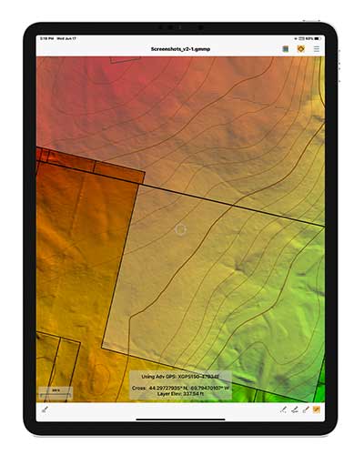
    Version 2.1 of Global Mapper Mobile provides updates to both the free and Pro versions. The iOS and Android applications are designed for viewing and collecting GIS data, and provide situational awareness and location intelligence for remote mapping projects. A complement to the desktop version, the mobile app can display all supported vector, raster and elevation data formats. The release improves vector feature styling, terrain layer support and layer transparency setting. In the Pro version, it introduces advanced GPS support, allowing users to connect to external, high-accuracy Bluetooth GPS devices from vendors such as Eos Positioning and Bad Elf. It also allows access to detailed information including the satellite constellation, precise location information and the raw NMEA stream.

    Blue Marble Geographics, bluemarblegeo.com


    UAV

    Energy industry ops

    For monitoring UAS operations

    Photo: aerogondo/iStock/Getty Images Plus.Getty Images
    Photo: aerogondo/iStock/Getty Images Plus.Getty Images

    The AiRXOS Enterprise Energy Solution provides digital compliance, situational awareness of airspace and assets, inspection, emergency response/disaster recovery capabilities, analytics and asset performance tools in a connected platform. It runs on AiRXOS’ Air Mobility Platform — a secure, cloud-based, extensible platform that enables integration of an energy organization’s current applications and other UAS service suppliers. It brings all UAS lifecycle operations into one view, including infrastructure inspection, asset and crew management, and emergency operations after a natural disaster.

    AiRXOS, airxos.io

    Fixed-wing UAV

    For surveying and monitoring

    Photo: Hitec
    Photo: Hitec

    The Xeno FX is a fixed-wing platform optimized for efficient and cost-effective area survey and monitoring missions. Users can program the flight plan before launch to ensure thorough coverage of a target region. The fixed-wing design allows for efficient cruise and maximum time aloft. The Safe Launch protective feature means the propeller starts spinning only after the airframe has been safely hand launched. A quick-change modular payload system allows users to reconfigure their data-acquisition hardware for multiple missions. Constructed of Multiplex’s resilient Elapor foam, the folding wings make for compact storage and easy transport.

    Hitec, hitecnology.com  

  • Global Mapper SDK updated for greater geospatial intelligence

    Version 20 of the Global Mapper Software Development Kit (SDK) is now available, along with the accompanying Lidar Module SDK. Mirroring the most important capabilities of the desktop version of the software, the powerful developer’s toolkit provides software engineers with the means to embed the latest geospatial technology into their custom applications, according to software maker Blue Marble Geographics.

    An elevation contour image in Global Mapper SDK. (Screenshot: Blue Marble)
    An elevation contour image in Global Mapper SDK. (Screenshot: Blue Marble)

    Among the highlights of the version 20 release are dramatically improved vector data performance in both the 2D and 3D environments, updated 3D mesh rendering with colors now displayed in the 2D view, and faster display and export of online tiled datasets, the company said.

    For more than 25 years, Blue Marble’s affordable, user-friendly GIS software has been meeting the needs of users in industries including software, oil and gas, mining, civil engineering, surveying and technology companies, as well as government departments and academic institutions.

    The Global Mapper GIS application can display, convert and analyze virtually any type of geospatial data. The Global Mapper SDK and Lidar Module SDK provide software developers with a toolkit for accessing much of this functionality from within an existing or custom-built application.

    The SDK also enables the creation of custom toolbars and extensions to enhance the data processing and analysis functionality of the standard version of Global Mapper. This capability allows in-house developers to create a unique version of the application to meet their specific needs or for software companies to build custom products for commercial distribution.

    The functional highlights of the latest version of the SDK effectively illustrate the continued evolution of 3D GIS technology and Blue Marble’s commitment to providing a superior data processing engine for managing, visualizing and analyzing increasingly large 3D datasets. Such is the case with the improvements that have been made to the display performance of vector files with faster rendering in both 2D and 3D Views.

    The display of 3D meshes or models, such as those created in Global Mapper’s Pixels-to-Points tool, has been improved with the photo-realistic colors now displayed in the top-down view. Online data processing has also seen improvements with significant speed increases when loading and exporting tiled data sources.

    Additional upgrades to the SDK functionality include improved box resampling of color images, especially those with palettes; several new supported formats, including Cyclone PTX and Autodesk Recap (RCP and RCS) point clouds; new projections and datums, including GDA2020 (Australia) and TUREF (Turkey); and support for Intermap’s online NextMap worldwide elevation dataset.

    For users of the Global Mapper Lidar Module, the version 20 SDK release also introduces a wealth of new and updated functionality. Point clouds can now be thinned, from both a 2D and 3D perspective, reducing file size and improving efficiency; a gridded layer can now be created from the classification values associated with lidar points; and a new scripting option has been added to apply colors to a point cloud from underlying imagery.

    “The Global Mapper SDK has become one of the most important components of Blue Marble’s suite of geospatial products,” stated Patrick Cunningham, Blue Marble President. “Motivated by the rapid emergence of the desktop software as a major player in the GIS industry, developers are increasingly turning to the corresponding SDK to leverage the software’s powerful geoprocessing tools in a wide variety of third party applications. The improved data handling capability of the version 20 release demonstrates our commitment to providing tools that work efficiently with even the largest datasets.”

  • Global Mapper update improves 3D tools

    Blue Marble Geographics is offering a version 18.1 update to Global Mapper that includes numerous functional enhancements and introduces an new tools, upgrades to existing components, performance improvements and support for new formats and online data sources.

    The release of version 18 of Global Mapper in September 2016 introduced a redesigned interface with significantly improved layer and workflow management as well as enhanced 3D display.

    Building on this foundation, version 18.1 further improves the 3D experience with a new option to freeze the 3D View while working in the adjacent 2D view, speed improvements when rendering raster or 3D model formats, and improved functionality for creating 3D fly-though visualizations. For lidar module users, a new data quality-control tool is available for adjusting point cloud elevations to match surveyed ground control points.

    Blue Marble’s GIS software is used by hundreds of thousands customers throughout the world who need affordable, user-friendly, powerful GIS solutions. Users are in industries including software, oil and gas, mining, civil engineering, surveying and technology companies, as well as government departments and academic institutions.

    The release of version 18.1 offers numerous enhancements that are a testament to the ever-increasing importance of 3D data. Global Mapper’s 3D view, which introduced the ability to display an “infinite view” of all loaded 3D data in version 18, now offers the option to pause the 3D rendering when interacting with the 2D map. This streamlines workflow and significantly improves memory usage by eliminating the need to continually refresh the display.

    The rendering speed for 3D raster layers as well as 3D models has also been drastically improved. When creating a 3D fly-through visualization or recording, the flight parameters now include bank angle, to more realistically simulate a pilot’s eye view, and variable velocity, allowing the flight speed to be adjusted between segments.

    Other enhancements in version 18.1 include a new option to calculate a summary of the color statistics in a raster layer within a defined area; faster loading and display of large vector files such as shapefiles; support for many new formats, including exporting of LandXML and importing of RMaps/MBTiles and BPF lidar files; and expanded online data options including the General Bathymetric Chart of the Oceans (GEBCO).

    Users of the optional Global Mapper Lidar Module, which provides advanced point cloud processing tools, can now perform precise quality control of their data against established ground control points. This allows the elevation values associated with each point to be adjusted to conform to the surveyed elevations at these locations.

    “With more and more data having a height or elevation component, the importance of Global Mapper’s 3D viewing capability is underlined,” stated Blue Marble President Patrick Cunningham. “For several years, our development priority has been to optimize the user experience when interacting with lidar, DEMs or other 3D layers and with the release of version 18.1 we are seeing some of the results of that effort with more display control, improved 3D interaction, and stunning 3D visualization.”

    Blue Marble application specialists will be conducting a live webinar on Tuesday, March 21, during which they will showcase the highlights of this release. This hour-long presentation is scheduled to begin at 2 p.m. (U.S. Eastern Time) and it will provide an opportunity to both see the latest tools and to ask questions about the new functionality. Space is limited and registration is required so be sure to sign up today.

    For a complete list of new features and enhancements or to download a trial copy of Global Mapper 18.1, visit the website.

  • Blue Marble Offers Lidar Module Upgrade

    Blue Marble’s Global Mapper V17‘s Lidar Module is an optional enhancement to its software that provides advanced lidar processing tools, including automatic point-cloud classification, feature extraction, cross-sectional viewing and editing, faster surface generation, and more. It is designed for anyone using or managing terrestrial or airborne lidar as well as other point cloud datasets.

    The Lidar Module was first released with Global Mapper V15, and a host of new lidar tools have since been added. Building on the existing functionality for identifying ground, building and vegetation points in an unclassified point cloud, the latest release of the module includes a powerful new tool for detecting and automatically reclassifying above-ground utility lines.

    After customizing the reclassification parameters, such as minimum height above ground and linear offset threshold, the points representing power lines are automatically attributed with the Wire – Conductor ASPRS lidar class. Analysis of linear patterns in these reclassified points can subsequently be used to create 3D vector lines.

    Addressing a major concern among lidar users, the latest release of the Global Mapper Lidar Module provides an efficient and effective way to remove noise from point cloud data. This powerful filtering tool can reclassify or automatically delete any points that are beyond a prescribed elevation or height above ground threshold within a local area.

    Other enhancements to the module include dramatically faster data rendering and processing as well as updated filtering tools for selecting and, if necessary, removing points based on class, return intensity, color range, and many other parameters.

    Additional functionality offered in the Lidar Module includes:

    • A convenient Lidar Toolbar for easy access to key editing and analysis functions
    • Multiple gridding options for faster DSM or DTM generation
    • Access to point cloud files containing a billion points or more
    • Automatic point classification tools that automatically distinguish building, ground, vegetation and power lines and above-ground utility cables in unclassified layers
    • Feature extraction functionality to automatically create 3D building footprints, trees and power lines
    • Cross-sectional rendering using Global Mapper’s Path Profile tool for viewing and editing the point cloud in a vertical perspective
    • Advanced filtering options to efficiently remove erroneous or unneeded points
    • Detect and reclassify or delete noise points
    • Lidar scripting commands for streamlining workflow
    • Point colorization from underlying imagery offering photo-realistic point cloud rendering in Global Mapper’s 3D Viewer
    • Support for reporting lidar statistics
    • Support for importing and exporting most common lidar formats
    • Support for NIR (near-infrared) data


  • Blue Marble Hosts 6th User Conference in October

    The 2015 Blue Marble User Conference (BMUC) will take place in Arlington, Va., on Tuesday, Oct. 6. The annual event provides industry experts, Blue Marble software users, product developers, and applications specialists with a forum for sharing experiences and exchanging ideas on the current and future developments in the Global Mapper and Geographic Calculator platforms.

    Blue Marble’s geospatial data manipulation, visualization and conversion solutions are used worldwide by thousands of GIS analysts at software, oil and gas, mining, civil engineering, surveying, and technology companies, as well as governmental and university organizations.

    Following the success of last year’s User Conferences in Calgary and Houston, the 2015 conference is being consolidated into a single venue, just across the Potomac River from Washington, D.C. As with previous conferences, this event offers a unique and invaluable opportunity to learn about the latest innovations in Blue Marble’s suite of GIS applications; to hear from industry experts about their experiences working with Blue Marble technology; and to network with representatives from a variety of business sectors and government departments.

    Over the years, the BMUC has provided GIS professionals with the opportunity to learn how Blue Marble’s innovative geospatial applications are streamlining GIS operations across many industries and to learn how others are maximizing their investment in the software. One of the most popular segments in the BMUC agenda is case studies that demonstrate the inherent flexibility of the software and its ability to meet the challenges of today’s GIS data processing and management tasks. The 2015 event will continue this trend with industry experts from the U.S. Geological Survey, the U.S. military and prominent engineering and survey firms.

    “BMUC is the most important event on our calendar every year,” stated Patrick Cunningham, Blue Marble president. “Not only does it allow us to showcase some of the latest advancements in our applications, but it also provides us with an ideal forum in which to engage with our most dedicated users and to garner their input on the continued development of Blue Marble products.”

    Space at BMUC is limited and attendees are asked to pre-register to guarantee a spot at this event.

  • Global Mapper v16.1 Introduces 3D and UAV Video Playback Tools

    Global Mapper version 16.1, what Blue Marble terms an “interim release,” adds a UAV Video Playback Tool, new options to rotate the map view, and the ability to select and measure features in the 3D viewer. It is available for download.

    To introduce the new version, Blue Marble is presenting a free webinar titled “What’s New in Global Mapper v16.1” on February 19 at 2 p.m. EDT.

    The release includes a variety of updates to both the Global Mapper base product and the optional LiDAR Module. A new video playback tool allows users to play a video derived from the flight of an aircraft or UAV. The playback option displays a video file synced to any line feature with per-vertex times, fly-through lines or point features with recognized timestamp attributes.

    Version 16.1 of Global Mapper also offers the option to rotate the map view as needed, allowing the user to more clearly visualize any spatial data with a unique alignment. The automatic “Track Up” mode works when connected to a GPS device and rotates the map view based on the current GPS heading. The new release also introduces the ability to select vector features with the Digitizer tool in the 3D Viewer. This functionality links the 2D and 3D maps, allowing users the option to pan, zoom, measure, and add vector data in one viewer while automatically replicating actions and updating features in the other. The right-click menu enables users to perform many Digitizer operations on the selected features in the 3D window.

    Single-user license upgrades for version 15 are available for $169; upgrades are also available for USB dongles and network licenses. To purchase a dongle or network license upgrade, contact sales at [email protected].

  • DAT/EM Systems Releases Version 7.1 of Software Products

    DAT/EM Systems International has released the 7.1 edition of DAT/EM software products, including Summit Evolution, Landscape, Capture, MapEditor, Ortho+Mosaic, Airfield3D and Contour Creator. The advancements in the 7.1 DAT/EM Photogrammetric Suite represent the latest evolution in technology and are based on customer input and growth within the geospatial industry, the company said.

    DAT/EM Photogrammetric Suite Version 7.1 Highlights

    • A new Multiple Project Solution combines different project types that have any input coordinate systems and displays them in multiple viewports. The viewport cursors move together where the diverse projects share the same geographic area. This allows use of imagery from sources such as aerial, orthophoto, ADS, and satellite RPC at the same time.
    • Oblique imagery support in the aerial project type. Oblique options will apply for any imagery where omega and phi are greater than 15 degrees.
    • Enhanced printing options, such as print preview, print in anaglyph, print with boundaries, print with full superimposition, virtually print to TIFF, and print to a higher resolution.
    • A Direct Linear Transform (DLT) model has been added to Summit close range projects. This model allows Summit to orient photos without a known camera calibration.
    • Named Image Adjustments is a new tool that saves image adjustment profiles for repeated use. It can also link to a Channel Map configuration.
    • Aerial projects can now define image scale, earth curvature correction, and refraction correction by a new Use heights method, which defines individual model scales and is used in steep terrain.
    • A second generation beta of the Global Mapper Extension. The Extension connects Blue Marble Geographics Global Mapper with any Summit Evolution edition (Professional, Feature Collection or Lite).
    • LandScape offers a new slider to adjust the intensity of color.
    • All DAT/EM products support new file formats, including LAZ format for both read and write operations, all LAS 1.4 for read only, and LAS 1.4 non-waveform formats for read and write.

    View all of the upgrades and highlights by visiting the DAT/EM Release Notes.

  • Blue Marble Releases 2015 Dates for Training Sessions

    Blue Marble Geographics is hosting a series of training sessions, starting with a session in March in Washington, D.C.

    The sessions are aimed at GIS professionals, or those just starting a career that requires the use of GIS software training. All attendees who successfully complete the required courses will be recognized as a certified Global Mapper or Geographic Calculator user. For detailed information on the class content, see the register link below.

    Washington, D.C., Area

    Topics: Global Mapper, Applied Geodesy & the Geographic Calculator
    Registration Deadline: March 2, 2015
    Dates: March 16-20, 2015
    Time: 8 a.m. to 5 p.m.
    Location: Westfields Marriott Washington Dulles
    14750 Conference Center Drive, Chantilly, VA 20151

    Sign up Options: Sign up for one class or all four.

    Cost

    Length

    Title

    Date

    FREE

    8 hrs

    GM1: Introduction to Global Mapper

    March 16, 2015*

    $996 pp

    24 hrs

    All 3 Days of Global Mapper Certification Training

    March 17-19, 2015*

    FREE

    8 hrs

    GM1: Introduction to Global Mapper

    March 17, 2015*

    $498 pp

    8 hrs

    GM2: Advanced Data Processing

    March 18, 2015*

    $498 pp

    8 hrs

    GM3: LiDAR, 3D Modeling, & Terrain Analysis

    March 19, 2015*

    $498 pp

    8 hrs

    Applied Geodesy & Geographic Calculator Training

    March 20, 2015*

    2015 Public Training Locations

    Area

    Date(s)

    Registration Deadline

    Washington, DC

    March 16-20, 2015*

    March 2, 2015

    Ottawa, ON

    April 27-May 1, 2015*

    April 13, 2015

    San Diego, CA

    July 20-24, 2015*

    July 6, 2015

    Orlando, FL

    November 2-6, 2015*

    October 19, 2015

    * Dates are subject to change.

    For more information, visit Blue Marble’s Public Training page.

  • Blue Marble Releases Global Mapper v15.2 with New Automation

    A flattened terrain surface model with 3D Vector features using Global Mapper.
    A flattened terrain surface model with 3D Vector features using Global Mapper.

    Blue Marble Geographics has released Global Mapper version 15.2, a minor release that adds functionality to automate the New Feature Creation process, as well as the addition of new online datasources, including OpenStreetMap vector data links via Web Mapping Services (WMS).

    Blue Marble’s geospatial data manipulation, visualization and conversion solutions are used worldwide by GIS analysts at software, oil and gas, mining, civil engineering, surveying, and technology companies, as well as governmental and university organizations.

    The minor release features updates to both the Global Mapper base product and the Global Mapper LiDAR Module. In particular, new functionality has been added to allow the user to automate the New Feature Creation process. Users can now create a series of features that share the same attribute structure, target layer, and other characteristics without having to repeatedly confirm these settings in the Modify Feature Info dialog box. This release also features the addition of free online datasources including full access to the Maine GIS catalog, as well as access to Aviation Charts and OpenStreetMap vector data via WMS.

    Other enhancements include support for creating buffer areas around line features with variable width from beginning to end and for creating buffers on just one side of a selected line feature. New scripting functionality has been added to allow conditional (IF/THEN/ELSE) processing within a script file. 3D models from Collada DAE files have been updated with the option to load BMP, JPG, PNG, and TIFF images with no geo-position information directly, improved 3DPDF support, and enhancements to CityGML.

    “These great new features and functions will streamline the user’s workflow, as well as save them time and money with the ease-of-access to a growing list of cloud based publicly available data,” stated Blue Marble President, Patrick Cunningham “This release is another great example of our mission to deliver a low-cost and easy-to-use GIS solution for everyone.”

    Enhancements to the LiDAR Module in v15.2 include added support for the transformation (shift/rotate/scale) of LiDAR point clouds and the option to filter selected LiDAR points to a certain elevation range and/or set of colors. A new LIDAR_CLASSIFY script command for classifying ground points in a script has been added. Users now have the option to keep the original file offset/scale, or to specify a new one when exporting to LiDAR LAS/LAZ files. They also now have the ability to crop to a selected area when specifying the bounds to import from a LiDAR point cloud and the ability to export point cloud to Esri File Geodatabases (GDB) as normal 3D point features. These LiDAR enhancements are a great addition to an already powerful module for those interested in adding advanced LiDAR functionality to Global Mapper.

  • Blue Marble Releases 13.1 Update to Global Mapper Software Developer Toolkit

    Blue Marble Geographics announced the release of Global Mapper Software Developer Toolkit version 13.1. This update features many new drawing and analysis tools along with enhanced geospatial PDF and LAS 1.4 support.


    According to the announcement, Global Mapper SDK 13.1 syncs up the software developer toolkit with Global Mapper desktop software releases. This will enable a more consistent release cycle ensuring the software developers are able to work with the latest and greatest feature/functions introduced to the desktop version of the software. The 13.1 release introduces many new drawing tools such as drawing map layout items, including elevation legend, distance scale, map feature legend, and north arrow. The update also introduces powerful new analysis tools like the function for creating density/heat grids from loaded point features, the function for creating roughness length grids from a land cover layer and the method for easily calculating a watershed with stream paths and drainage basins from loaded terrain layers. The ability to add custom online data sources is introduced along with improved Geospatial PDF support, new LandXML, LASzip and LAS 1.4, I.H.S. Well Data point files, GeoJSON, and Digital Bathe Bathymetric Database Variable Resolution (DBDB-V) files and much more.

    “Blue Marble has been directly supporting hundreds of geospatial software developers implement cutting edge technology for years,” stated Blue Marble President Patrick Cunningham. “The Global Mapper SDK is a great tool to add to a suite of libraries and we are excited to work directly with our developer community with this new display and translation api. Syncing up the SDK kits with the desktop releases will help us provide the latest features and functionality to our existing users as well as new customers for future releases.”

    Blue Marble’s geospatial data manipulation, visualization, and conversion solutions are used worldwide by thousands of GIS analysts at software, oil and gas, mining, civil engineering, surveying, and technology companies, as well as governmental and university organizations.

  • Blue Marble Releases 13.1 Update to Global Mapper

    Blue Marble Geographics announced the release of Global Mapper version 13.1. This update features new network licensing, enhanced geospatial PDF support and much more. Blue Marble’s geospatial data manipulation, visualization and conversion solutions are used worldwide by thousands of GIS analysts at software, oil and gas, mining, civil engineering, surveying, and technology companies, as well as governmental and university organizations.

    According to the announcement, Global Mapper 13.1 introduces Flex LM licensing to the software which provides multi-seat users with a flexible network licensing function. This efficient checkout or borrowing process allows easier access to the software across entire organizations, paving the way for new enterprise features in coming releases. The 13.1 update also introduces new geospatial PDF functionality such as the ability to import and export to 64-bit versions, the ability to select which layer to load from a geospatial PDF and the ability to load multi-page PDFs with geo-positioning. Additional enhancements include support for LAS version 1.4 and LASzip files, GeoJSON formatted data, Digital Bathymetric Database Variable Resolution (DBDB-V), LandXML files and over fifteen additional new formats. Version 13.1 also includes significant speed increases to the depression filling step when generating watersheds/drainage areas, added built-in access to land cover datasets and generation of grids from layers, significant enhancements to the Digitizer tool as well as many other minor enhancements and updates throughout the software.

    "For a minor version release, this update is quite comprehensive," stated Blue Marble President Patrick Cunningham. "We are just starting to bring the support of our development team to assisting lead product developer, Mike Childs and we’re already seeing some great gains. Look for many more great enhancements over the next year."

  • Blue Marble Offers Applied Geodesy Training in Houston After the GIS for Oil and Gas Show

    September 9, 2006 — Blue Marble Geographics will be offering applied geodesy training in their Geographic Calculator class after the GIS for Oil and Gas Conference on Friday, September 22, 2006. The day-long session is an in-depth training course using the Geographic Calculator, a flexible data-conversion application.

    The course also features education on the basics of geodesy and mapping. Blue Marble will also be exhibiting at the Geographic Information & Technology Association GIS for Oil and Gas Conference at booth number 502.

    The Geographic Calculator converts individual coordinates, point database files, and vector map files from virtually any coordinate system to any other. Users can transform between coordinate systems, calculate the distance and azimuth between two coordinates, and calculate new coordinates at a known distance and azimuth from known coordinates. The Geographic Calculator also automatically computes grid convergence, point scale factor, datum shifts, and grid shifts.

    Call toll free 800-616-2725 to reserve a spot in the class.