Tag: Brazil

  • Topcon launches innovations aimed at farmers at Brazil Agrishow

    Topcon launches innovations aimed at farmers at Brazil Agrishow

    As Brazilian farmers face increasing pressure to improve efficiency while managing rising input costs, Topcon Agriculture has announced a new set of innovations designed to expand access to precision technology across Latin America.

    At Agrishow 2026, taking place April 27–May 1 in Brazil, Topcon will showcase solutions for row crop, coffee, citrus and sugarcane growers, including an expansion of its Value Line portfolio into vineyard and orchard spraying applications, as well as the introduction of a new modular GNSS receiver for precision agriculture.

    XR-1P GNSS receiver

    Modular GNSS receiver. Topcon is introducing the XR-1P GNSS receiver, designed to deliver reliable positioning and manual guidance in a cost-effective, durable unit. Engineered with modular architecture, the XR-1P can be used as a standalone solution or integrated into broader Topcon systems, offering flexibility for a wide range of farming operations.

    The receiver is designed to bridge the gap between entry-level positioning solutions and high-performance precision agriculture systems, making advanced GNSS technology more accessible without compromising reliability.

    CM-20 V spray controller

    Expanding precision spraying for specialty crops. The CM-20 V Spray Controller, part of Topcon’s vineyard and orchard spraying control portfolio, is now available for use with the Value Line Steering solution. Designed for front-wheel-drive, mid-range tractors, the system offers an economical and scalable approach to precision spraying for specialty crops such as coffee and citrus.

    The universal ISOBUS electronic control unit (ECU) integrates easily with existing farm equipment, regardless of brand, while on-the-go sensor-based control adjusts application rates based on crop density. This helps reduce input waste, minimize over- and under-application, and improve overall crop health and operational efficiency.

    Sugarcane solution preview. An advanced look at a pre-commercial Sugarcane Yield Monitoring Solution will be showcased at the event. In development with the specific needs of Brazilian agriculture in mind, the solution will provide accurate, real-time yield visibility designed to maximize harvester efficiency, optimize logistics and support precision agronomy. By enabling more precise decision-making, the solution will help reduce input usage while increasing productivity in one of the country’s most strategic crops.

    Boom height controller

    Brazil is a strategic market for Topcon Agriculture, as it is one of the world’s leading food producers. Topcon supports the region not only through innovations tailored to local agricultural needs but also through a strong and expanding network of distributors that provide access to technology, training, and ongoing support. Authorized dealers, including Agrosure, Alagro, Coopercitrus and WiseAgri in Brazil, as well as Nievas in Argentina and Gestecner in Paraguay, will be at the Topcon stand during Agrishow.

  • u-blox, Nordian introduce PointPerfect GNSS correction service to Brazil

    u-blox, Nordian introduce PointPerfect GNSS correction service to Brazil

    Image: u-blox
    Image: u-blox

    u-blox has partnered with Nordian Positioning Solutions to expand coverage of the PointPerfect GNSS correction service to Brazil.

    The collaboration aims to facilitate precise positioning for various applications, with a focus on high-precision agriculture, service robots, machinery automation, micro-mobility and emerging automotive applications, such as lane-accurate navigation and telematics.

    PointPerfect is designed to provide centimeter-level accuracy and achieve convergence in seconds with 99.9% uptime reliability. The service ensures uniform coverage across the globe. Notably, PointPerfect’s recently introduced Localized Distribution feature is intended to reduce user data costs by using 90% less data than typical network real-time kinematic (RTK) services. This combination of low-bandwidth data stream and flexible service plans offers easy scalability for future needs.

  • EAB Q&A: Should countries build their own GNSS constellations?

    EAB Q&A: Should countries build their own GNSS constellations?

    “When Galileo was just an idea, its EU proponents used the argument of “political, economic, social and technological sovereignty.” Should countries such as Brazil build their own GNSS constellations?”


    Headshot: Ismael Colomina
    Ismael Colomina

    “When, almost 20 years ago, I was in Brazil giving talks about the future of Galileo and promoting its combined use with GPS, I was often asked the logical question as the EU Galileo sovereignty arguments were known. It is not for us Europeans to answer that question for other countries or oppose their plans. However, while being aware of the defense aspects of GNSS, we may ask ourselves whether an international cooperative approach could avoid a somewhat unjustified future proliferation of GNSS constellations.”

    — Ismael Colomina
    GeoNumerics


    Headshot: Jules McNeff
    Jules McNeff

    “GPS enables continuous access, free of fees and political encumbrances. A decision by any nation to bear the cost of creating a separate GNSS should be justified by realistic requirements for security or coverage that cannot be satisfied by GPS. Japan, South Korea and India are models for additional GNSS services driven by regional needs. For any new system, compatibility with other GNSS, as well as life-cycle costs, are the primary factors to consider.”

    — Jules McNeff
    Overlook Systems Technologies


    Headshot: John Fischer
    John Fischer

    “When Galileo was just an idea, the U.S. military’s GPS was the only viable global constellation. GLONASS was a rusting cold-war relic and BeiDou was in an embryonic stage. The U.S. military’s official policy was that any civilian use was not guaranteed and could be interrupted anytime. Therefore, no nation outside of the United States could depend on GPS and maintain its independent interests. However, today, any country could reasonably maintain its sovereignty by ensuring interoperability with all four — betting that at least one of those constellations would always be available to them. They don’t need their own system.”

    — John Fischer
    Orolia


    F. Michael Swiek
    F. Michael Swiek

    Those are always nice-sounding words when trying to justify a monumentally huge expense. However, is there an actual need to justify that expense? Can the expense and burden of perpetual system operation and maintenance, along with technological innovation to keep pace with other systems and user requirements, be guaranteed over the long term? For the users, GPS can be seen as the gift that keeps on giving, whereas to the operators it is the gift that keeps on costing. So, do Brazil, or other nations, have the commercial or social need, technological foundation, economic resources and political will to initiate a new system and sustain it over the long term? Providing a GNSS constellation is not for the faint of heart or those of short-term vision.

    — Michael Swiek
    GPS Alliance

  • DroneShield counter-UAS products head to Australia, Brazil

    DroneShield counter-UAS products head to Australia, Brazil

    Counter-unmanned aircraft system (C-UAS) company DroneShield has sold its RfOne MKII long-range sensors to the Australian Army. The capability is being delivered immediately to allow the Australian Army to assess its future counter-drone requirements and options, the company said.

    “As an Australian company, DroneShield is immensely proud to support the Australian Army with its long-range counter-drone strategy, said DroneShield CEO Oleg Vornik.

    Deployment of the long-range sensors will highlight the flexibility, resilience and capabilities of DroneShield equipment in a dynamic field environment, while also assisting the Australian Army in establishing its counter-drone requirements and future capability options.

    The sale, announced July 19, was structured as a one-off sale to the Australian Army. Similar to the standard purchases from DroneShield’s other defence and law enforcement customers, comprises a small purchase of equipment.

    Australian counter-unmanned aircraft system (C-UAS) company DroneShield has sold several of its RfOne MKII long-range direction-finding sensors to the Australian Army. The deal, announced July 19. and will “allow the Australian Army to assess its future counter-[UAS] requirements and options”, DroneShield said in a statement, as well as equipping existing platforms with the sensors.

    Brazilian Sale

    DroneShield also has received formal approval from Anatel, the Brazilian National Telecommunications Agency responsible for issuing the concession of new radio frequencies. Following approval earlier this month, the company has sold a quantity of its DroneGun Tactical units to the Brazilian government.

    “Brazil is a large and sophisticated market for military and security equipment, and we are pleased to commence active presence in the country, deploying equipment to the customers,” Vornik said. “We look forward growing our presence in Brazil with the urgent counter-drone requirements mirroring what we are seeing in other countries.”

    New Kit

    Immediate Response Kit. (Photo: DroneShield)
    Immediate Response Kit. (Photo: DroneShield)

    DroneShield also released its Immediate Response Kit (IRK), a rapidly deployable C-UAS detection and defeat kit. The IRK consists of an RfPatrol portable (1.2 kg/2.6 lbs incl battery) detection device and a DroneGun MKIII (2.1 kg/4.7 lbs including battery) defeat device in a rugged carry case.

    Both RfPatrol and DroneGun MKIII are currently fielded by military and government customers globally.

  • Brazil approves SenseFly eBee X for BVLOS operations

    Brazil approves SenseFly eBee X for BVLOS operations

    Brazil’s Civil Aviation Authority approves  Flagship Fixed-wing Drone 

    The eBee X. (Photo: senseFly)
    The eBee X. (Photo: senseFly)

    The National Civil Aviation Agency (ANAC) of Brazil has approved beyond-visual-line-of-sight (BVLOS) flights using SenseFly‘s flagship eBee X fixed-wing drone.

    ANAC’s decision means that the senseFly eBee X is officially approved for use in future BVLOS missions carried out by Brazilian drone operators. The drone received approval by demonstrating the safety requirements of the ANAC RBAC-E 94 Regulation for Unmanned Aircraft, through detailed engineering analyses and in-depth flight testing. Sensefly worked in collaboration with drone engineering and consulting specialists AL Drones and geotechnology company Santiago & Cintra.

    Following the certification, senseFly eBee X operators in Brazil now only require a CAER (Special Airworthiness Certificate for RPA) waiver for the aircraft with Santiago & Cintra before flying BVLOS operations.

    “The commercial drone industry in Brazil has been growing at a phenomenal rate. and we’re excited that the senseFly eBee X is at the forefront of these regulatory developments,” said Pierre-Alain Marchand, regulatory compliance manager, senseFly. “BVLOS is becoming an important tool for operators as they start to explore the potential of more advanced drone operations, and we’re pleased that our technology continues to help define frameworks and legislation in the country. Historic approvals passed in recent years has shown us that Brazil is one of the countries to watch for drone commercialization, so continue to watch this space!”

    The authorization comes following approval of senseFly’s proprietary drone technology in 2017, where the use of drones for civil applications in Brazil were legislated as part of the RBAC-E94 regulation. SenseFly drones became the first and only in the country permitted to fly 400 feet in height with a 5 kilometer radius from a licensed pilot or observer, in contrast to previous VLOS operations that restricted use of drones to a 500-meter radius.

    “The authorization of senseFly’s eBee X for BVLOS operations is another step towards commercialization of the sector,” said André Arruda, co-founder of AL Drones. “After years of collective hard work and effort from all parties, this certification presents a real opportunity for operators in the future to expand their mapping operations and achieve a robust return-on-investment. We look forward to seeing what this means for BVLOS operations in Brazil in the coming years.”

    SenseFly’s eBee X fixed-wing drone is designed to suit a wide range of mapping jobs. At 1.6 kg (3.5 lbs.), eBee X is a lightweight, portable solution that is easy for a single person to operate. With an Endurance Extension option enabling a flight time of up to 90 minutes and single-flight coverage of up to 500 ha at 122 m (1,236 A at 400 ft.), the eBee X drone that offers users the high precision of on-demand RTK/PPK for achieving absolute accuracy down to 1.5 cm (0.6 in) without ground control points. This capability makes the eBee X suitable for BVLOS operations such as long corridor mapping missions for utility companies, expansive crop scouting in agriculture and by enterprise customers who desire a robust and professional drone fleet.

  • Sonardyne chosen for Brazilian geoscience research vessels

    Sonardyne chosen for Brazilian geoscience research vessels

    Sonardyne logoBrazilian geoscience services company OceanPact Geociências has chosen deep-water positioning technology from Sonardyne Brasil Ltda. to support its geophysical, geotechnical and environmental research operations across the region.

    Ranger 2 ultra-short baseline (USBL) systems have been installed on board OceanPact’s research vessel Seward Johnson and RSV Austral Abrolhos to precisely track the location of underwater equipment and sensor packages deployed from the ships, including seabed corers, towed sensors and data loggers. Both vessels are currently on hire to Brazilian oil major Petrobras.

    Ranger 2 USBL is a popular choice for conducting research at sea as operations can start as soon as a vessel arrives on location. This helps maximise valuable ship time. It has the capability to track multiple underwater targets simultaneously to beyond 11 kilometers, works in shallow or deep water and is able to remotely configure and communicate with compatible instruments. This operational flexibility was a key factor in OceanPact’s investment decision.

    “This order from OceanPact further embeds Ranger 2’s reputation in the region. For those wanting accuracy and versatility, it’s proven itself time and again while also meeting the toughest specifications from oil and gas, science and survey companies,” Andre Moura, sales and applications manager at Sonardyne Brasil Ltda.

  • Amazon fires in Brazil can be seen from space

    Amazon fires in Brazil can be seen from space

    Wildfires in the Amazon rainforest in Brazil have hit record numbers, and satellites have been able to capture imagery of them.

    According to NASA, the Moderate Resolution Imaging Spectroradiometer on its Aqua satellite captured images of several fires burning in the states of Rondônia, Amazonas, Pará and Mato Grosso on Aug. 11 and Aug. 13.

    A satellite view of the Amazon wildfire on Aug. 13. (NASA Earth Observatory images by Lauren Dauphin, using MODIS data from NASA EOSDIS/LANCE and GIBS/Worldview and VIIRS data from NASA EOSDIS/LANCE and GIBS/Worldview, and the Suomi National Polar-orbiting Partnership.)
    A satellite view of the Amazon wildfire on Aug. 13. (NASA Earth Observatory images by Lauren Dauphin, using MODIS data from NASA EOSDIS/LANCE and GIBS/Worldview and VIIRS data from NASA EOSDIS/LANCE and GIBS/Worldview, and the Suomi National Polar-orbiting Partnership.)

    There have been 72,843 fires in Brazil this year, with more than half in the Amazon region, Brazil’s space research center, the National Institute for Space Research (INPE), said. This marks an 84% increase over the same period of 2018 and is the highest since records began in 2013, INPE added.

    Amazonas, the largest state in Brazil, recently declared a state of emergency over the forest fires, said Euro News.

    This map shows the "Biomass burning aerosol optical depth." (Image: Copernicus' Atmosphere Monitoring Service)
    This map shows the “Biomass burning aerosol optical depth.” (Image: Copernicus’ Atmosphere Monitoring Service)

    In the Amazon region, fires are rare for much of the year because wet weather prevents them from starting and spreading. However, in July and August, activity typically increases due to the arrival of the dry season, NASA said.

  • Terra Drone Brazil conducts unmanned offshore tank inspection

    Terra Drone Brazil conducts unmanned offshore tank inspection

    Terra Drone Brazil, a group company of Japan-based Terra Drone Corp., has successfully completed Brazil’s first drone inspection of an offshore FPSO tank. The unmanned FPSO tank inspection was undertaken for Brazil’s state-owned oil company Petrobras.

    The ballast tank inspection using drones was conducted aboard P-66, a floating production, storage and offloading (FPSO) unit from Petrobras that is operating in the Pre Salt Area at Santos Basin. An FPSO is a floating vessel used by the offshore oil and gas industry for the production and processing of hydrocarbons, and for the storage of oil.

    Petrobras needs its cargo and ballast tanks inspected regularly for maintenance. Any kind of corrosion, cracks, fractures or welding anomalies must be identified quickly before they can damage the structural integrity of the ship.

    The drones are prepped for the tank inspection. The UAV inspection just over an hour. (Photo: Terra Drone)
    The drones are prepped for the tank inspection. The UAV inspection just over an hour. (Photo: Terra Drone)

    Traditionally, this inspection is done by sending a team of up to four men inside the confined tank space using scaffolds or rope access. This kind of close-up visual inspection of one tank alone can take from half a day to a full day, and pose a safety threat to the workers inside the tank.

    Using drones reduces the need for workers to enter the tank. “Not only is unmanned FPSO tank inspection safer, but it is also much quicker and more precise than manual inspection,” said Marcelo Belleti, executive director at Terra Drone Brazil. “Further, drone inspections for cargo tanks can lead to potential cost-savings as well.”

    Terra Drone Brazil completed the inspection of a ballast tank for Petrobras in little over an hour with a team of only two men. The high-definition pictures and videos captured by the drone ensured a quality deliverable report for all 40 points pre-defined for the close-up inspection.

    Terra Drone Brazil is certified by ABS (American Bureau of Shipping), DNV GL (Det Norske Veritas and Germanisher Lloyds) and Loyd’s Register as a service supplier approved for surveying using Remote Inspection Techniques (drones) as an alternative means for a close-up survey of the structure of ships and mobile offshore units. The Petrobras P-66 is ABS-certified.

  • University of Nottingham GNSS project to boost precision agriculture in Brazil

    Photo: University of Nottingham
    Photo: University of Nottingham

    The University of Nottingham is working with Brazilian and European Union (EU) partners to solve atmospheric interference problems that hamper satellite-based positioning in equatorial countries like Brazil.

    The research network will support the advancement of precision agriculture, which aims to make crop farming practices cheaper, greener and more efficient using satellite positioning and remote sensing.

    These technologies rely on GNSS (such as GPS and Galileo) to obtain centimeter-accurate coordinates on Earth. Farmers then use this real-time precise data to optimize fertilizer use, to steer driverless machinery and for soil mapping to maximize crop production in a bid to feed a rising world population.

    Despite its revolutionary potential, precision agriculture adoption rates in countries on equatorial regions such as Brazil are hindered by ionospheric scintillation in the Earth’s upper atmosphere.

    Ionospheric scintillation affects the integrity, availability and accuracy of satellite positioning. Specifically, it causes interference with the propagation of satellite signals as they pass through the ionosphere, making it difficult for GNSS receivers to lock onto satellites and track their signals. This results in not only large errors but sometimes to service outages.

    “The strong signal fluctuations that characterize ionospheric scintillation are caused by the irregular behavior of the ionosphere that is typical of the equatorial latitudes, affecting most of the Brazilian territory, hence the importance of the bilateral collaboration in the PEARL network,” said project leader Marcio Aquino from the Nottingham Geospatial Institute at the University.

    The PEARL network, which is funded by the European Commission’s INCOBRA project, aims to tackle this problem head on to ensure high-accuracy positioning by satellite is robust and achievable in real time in Brazil.

    “Solutions arising from the research will have a positive impact not only in Brazil but in the whole of Latin America, due to its geographical location near the equator and corresponding disruptive ionospheric effects,” Aquino said. “It could play a pivotal role in promoting the uptake of satellite-based positioning and the broad acceptance of the new EU system Galileo, paving the way for service implementation in other similarly affected parts of the world, such as southern China, India, Indonesia and Malaysia.”

    Research and industrial partners from both Europe and Brazil will come together on the seven-month initiative to develop strategies to map the causes of ionospheric scintillation and specialized algorithms to model and mitigate their effects on satellite-based positioning.

    These strategies will be part of a large Brazil-EU collaborative proposal to be submitted to the forthcoming H2020 SPACE-EGNSS call due out in October 2018.

    Network members include small to medium enterprises in Europe and Brazil that are keen to incorporate new solutions that will improve their satellite-based services.

    The PEARL network encompasses:

    1. University of Nottingham, UK; Sao Paulo State University and Universidade do Estado de Mato Grosso, Brazil.
    2. National Institute of Geophysics and Volcanology and SpacEarth Technology (an SME), Italy.
    3. Space Research Centre of Polish Academy of Sciences, Poland.
    4. Three small and medium-sized enterprises (SMEs): Geo++, Germany, and Alezi Teodolini and MC Engenharia Ltd, Brazil.

    The European Commission funds the INCOBRA project to increase and enhance Research and Innovation cooperation activities between Brazil and the European Union. PEARL is one of INCOBRA’s bilateral R&I cooperation networks, led by the University of Nottingham, addressing one of INCOBRA’s priority areas, namely bio-economy, food security and sustainable agriculture.

    According to the latest issue of the GSA GNSS market report (issue 5, 2017), revenue for GNSS device sales in precision agriculture will grow to nearly €3 billion by 2025, quadrupling from €750 million in 2013 (based on GNSS receiver sales to just this market segment).

  • Joint NASA-Brazil CubeSat mission will unlock equatorial phenomena that affect GPS

    NASA and a team of Brazilian space researchers have announced a joint CubeSat mission to study phenomena in Earth’s upper atmosphere — a region of charged particles called the ionosphere — capable of disrupting communications and navigation systems on the ground and potentially impacting satellites and human explorers in space.

    Two phenomena in the ionosphere — equatorial plasma bubbles and scintillation — have impacted GPS signals, radio communication systems and satellite technologies for decades, said Jim Spann, chief scientist for the Science and Technology Directorate at NASA’s Marshall Space Flight Center in Huntsville, Alabama.

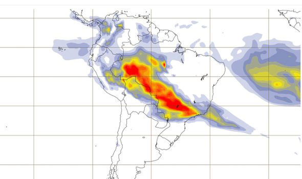
    Equatorial plasma bubbles are regions of comparatively low density which may elongate into towering plumes during high-intensity periods.

    Scintillation is a unique type of atmospheric fluctuation that can interrupt radio frequencies, much like the “twinkling” effect seen in starlight when optical frequencies are disrupted.

    The Scintillation Prediction Observations Research Task (SPORT) mission, funded by NASA’s Science Mission Directorate in Washington, will observe these peculiar structures in order to understand what causes them, determine how to predict their behavior and assess ways to mitigate their effects.

    The joint U.S.-Brazilian team, led by Spann as principal investigator, will design and launch SPORT as a CubeSat, a compact satellite about the size of two loaves of bread. It will be launched in 2019 to an Earth orbit 217-248 miles high (350-400 km). Its operational phase is expected to last at least a year.

    “Degraded communications and GPS signals are known to be closely linked to these phenomena,” Spann said. It’s his goal to shed new light on these phenomena and inspire new operational solutions to contend with the disturbed conditions.

    Protecting Brazil’s aviation, agriculture

    The Brazilian SPORT team seeks targeted solutions as well. Otavio Durão, project manager for the team at Instituto Nacional de Pesquisas Espaciais (INPE) in São Jose dos Campos, a São Paulo municipality, said ionospheric responses to a space phenomenon called the South Atlantic Anomaly or the South American Magnetic Anomaly — where space radiation dips close to Earth — negatively impacts Brazil’s busy airports.

    “Our country is interested in refining GPS signal processing, making takeoffs and landings safer and more precise,” he said. “Because so many international flights come to and through Brazil, this should be a matter of concern for all countries.”

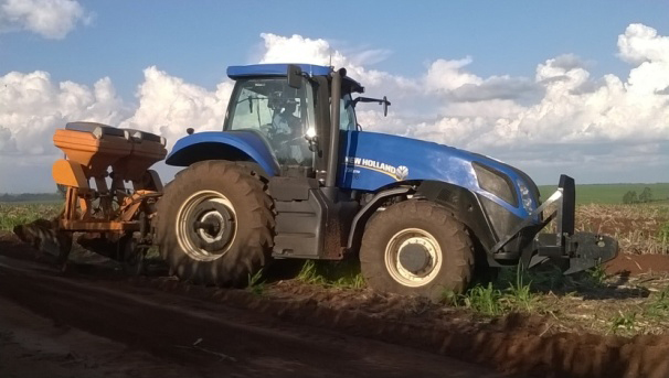
    Brazil’s strong agricultural industry also is concerned about the anomaly’s effects on GPS, said Durão’s colleague Luís Loures, the SPORT spacecraft manager at the Instituto Tecnológico da Aeronáutica in São Jose dos Campos.

    “Our agribusiness is always trying to increase crop productivity,” he said. “One way to accomplish this is by using automated tools. But being able to precisely position those automated tractors and field sprayers, without disruption from solar phenomena, is crucial.”

    “As society becomes more dependent every day on space-based technology — cell phones, self-driving cars, secure military communications — it’s critically important we first understand the environment in which our technology resides, then learn how to operate through and preserve it from potentially disruptive or damaging interference,” Spann said.

    Understanding the phenomena

    Building on decades of previous ground-based studies of plasma bubbles over equatorial regions, especially intensive research in Brazil and Peru, SPORT will help researchers determine what’s happening in the ionosphere to stir up the bubbles, why they form along the equator and what causes them to appear at night.

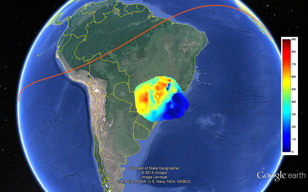
    Plasma bubbles and scintillation are global equatorial and mid-latitude phenomena, made worse by the South American Magnetic Anomaly, where Earth’s magnetic equator dips close to Earth.

    “Many of the discoveries to date have been confined to a limited number of longitudinal sectors,” Spann said. “SPORT will make a systematic study of the ionosphere at all longitudes around the planet, documenting the conditions that trigger formation of the bubbles, with particular focus on the South American sector.”

    As multiple instruments on the ground also record data, Spann said, SPORT will probe the ionosphere from above. During subsequent passes, it will study specific sectors to identify conditions favorable for developing plasma bubbles and ionospheric scintillations.

    These simultaneous satellite and ground-based studies will help researchers identify how the observations are related, providing a better understanding of the results at all longitudes.

    The team is confident the findings will enable researchers to use physics-based models to determine the physics of plasma bubble triggers, and thus identify the resulting scintillation of radio signals that propagate throughout the turbulent region.

    More about SPORT

    SPORT science mission data will be distributed from and archived at the EMBRACE space-weather forecasting center in Brazil’s National Institute for Space Research (INPE) and mirrored at the Space Physics Data Facility at NASA’s Goddard Space Flight Center in Greenbelt, Maryland.

    The SPORT mission management team is led by Marshall alongside its international partners, the Brazilian Space Agency in Brasília, and the National Institute for Space Research and Technical Aeronautics Institute, both in São Jose dos Campos, São Paulo.

    Spann’s team, which oversees the mission science, flight instruments and the CubeSat launch, includes researchers at Marshall; Goddard; Utah State University in Logan, Utah; The Aerospace Corporation in El Segundo, California; the University of Texas at Dallas; and the University of Alabama in Huntsville.

    NASA’s Brazilian partners are overseeing the development of the spacecraft; integration and testing; mission operations; data management and dissemination; and the ground observation network. The science analysis will be conducted by the entire team.

    SPORT is part of NASA’s Heliophysics Technology and Instrument Development for Science program. NASA’s heliophysics mission includes research into the effects of the sun on Earth, its atmosphere and the planets of our solar system.

  • Septentrio Americas delivers machine control receivers for world’s largest iron ore mine

    Septentrio Americas delivers machine control receivers for world’s largest iron ore mine

    The Vale S11D mine is the largest iron ore mine in the world.
    The Vale S11D mine is the largest iron ore mine in the world.

    Vale’s new S11D mine is the largest iron ore project in the world. It will produce more than 90 million tons of iron ore annually when it becomes operational in the second half of 2016. Vale is leveraging technology from Septentrio and other mining companies to implement a highly automated truckless transport system that will substantially reduce fuel consumption and emissions, as well as saving water.

    The Vale S11D machine control project is being managed from Septentrio Americas in Torrance, California.

    Septentrio GNSS receivers and antennas will be deployed across a range of machines to provide highly accurate and reliable position and orientation. The AsteRx-U receiver family features built-in jamming detection and countermeasures, multipath rejection and fast acquisition.

    With more than 500 channels to track all available constellations (GPS, GLONASS, Galileo, Beidou, IRNSS and QZSS), the receivers offer a built-in L-band receiver for PPP corrections as well as centimeter-level RTK positioning accuracy.

    The AsteRx-U family also incorporates proprietary Septentrio algorithms, including LOCK+ technology to maintain tracking during heavy vibration from the machine and IONO+ technology to assure the accuracy of the position even in regions of elevated ionospheric activity. The receiver is configurable from any device with a web browser, and includes advanced capabilities such as a built-in spectrum analyzer.

    “Septentrio has been a leader in multi-constellation and multi-frequency machine control GNSS receivers for the past decade,” said Neil Vancans, vice president of Septentrio Americas. “The selection of AsteRx-U receivers for Vale’s S11D project is a strong validation of Septentrio’s rugged design and high performance in challenging environmental conditions.”

  • A Scintillating Project

    A Scintillating Project

    FIGURE 2. TEC map over São Paulo state as forecast by the CALIBRA model on Sept. 26, 2012, at 2:00 UT. The range of the TEC in the image is from 0 to 90 TEC units (blue to red). The red line is the geomagnetic equator.
    FIGURE 2. TEC map over São Paulo state as forecast by the CALIBRA model on Sept. 26, 2012,
    at 2:00 UT. The range of the TEC in the image is from 0 to 90 TEC units (blue to red). The red
    line is the geomagnetic equator.

    Countering Ionospheric Disturbances Affecting GNSS in Brazil

    By Marcio Aquino

    After 27 months of intense research, the CALIBRA project ended successfully in February 2015, with the project team devising solutions to tackle the effects of perturbations typical of the Brazilian ionosphere on high-accuracy GNSS positioning. CALIBRA was funded by the European Union and the European GNSS Agency.

    Kicked off in 2012, CALIBRA first confirmed the vulnerability of GNSS high-accuracy techniques to ionospheric disturbances through a thorough user performance review, where degradation in GNSS Precise Point Positioning (PPP) and real-time kinematic (RTK) positioning was seen to correlate with the occurrence of ionospheric scintillation and high Total Electron Content (TEC) variability. This is especially so in Brazil, because of its geographical location extending across the magnetic equator in one of the most troublesome ionospheric regions of the Earth, qualifying the country as a test-bed for worst-case scenarios.

    The team established a suitable metric to characterize these disturbances, which was used in developing the new models and algorithms to counter their effects. The short-term empirical CALIBRA Forecasting Model (CFM) for TEC and scintillation was developed and tested.

    To counter scintillation, a number of approaches were proposed and their benefits demonstrated. Building on the project’s success, CALIBRA partner INGV (Istituto Nazionale di Geofisica e Vulcanologia) filed a patent for the CFM and a new spin-off company — SpacEarth Technology — was set up. SpacEarth aims to secure the software’s commercialization for potential applications and services, while also improving and adapting it to evolving market needs.

    Another outcome of commercial interest is that project partner Septentrio developed several rover-level mitigation approaches, notably a new model for ionospheric delay estimation.

    Monitoring Network. To support the research and operational activities of the project, a dedicated network of ionospheric scintillation monitor receivers (ISMRs) was deployed, forming the CIGALA-CALIBRA network of 12 monitoring stations equipped with PolaRxS receivers. A web interface for data analysis — the ISMR Query Tool  — was developed by project partner UNESP (São Paulo State University) and is available for public use, collecting and treating more than 10 million observations of GPS, GLONASS, Galileo, BeiDou and other augmentation systems on a daily basis. Data visualization and data mining techniques support users in data analysis and knowledge extraction.

    Finally, two important field trials aiming to validate the new algorithms were carried out in Brazil, involving actual precision agriculture and offshore operations. For the precision agriculture trial, the Brazilian company Agro Pastoril Campanelli provided expert operational environment and support.

     The tractor used in the precision agriculture trial at Agro Pastoril Campanelli’s premises.
    The tractor used in the precision agriculture trial at Agro Pastoril Campanelli’s premises.

    For the offshore trial, the project counted on the collaboration of the DOF Brasil Group representing Norskan Offshore, a provider of high-end offshore services to the Brazilian oil and gas industry. Detailed results of both trials are in the project’s final report, which can be accessed through the GSA.

    The Geograph vessel is operated by DOF Brasil.
    The Geograph vessel is operated by DOF Brasil.

    Setting up the receiver antenna for the offshore trial on board the Geograph vessel.
    Setting up the receiver antenna for the offshore trial on board the Geograph vessel.

    To provide a glimpse of the performance of the CALIBRA algorithms during the offshore trial, in FIGURE 1 we selected a period when strong scintillation conditions were encountered. In the top plot, two height component time series for kinematic PPP processing are shown, respectively, for the case where no mitigation is applied (black time series) and the case where the CALIBRA algorithm is applied (red time series).

    FIGURE 1. Performance of CALIBRA algorithms in the offshore trial.
    FIGURE 1. Performance of CALIBRA algorithms in the offshore trial.

    The bottom plot shows the level of amplitude scintillation (S4 index) affecting the GPS satellites over a 10-degree elevation angle.

    The improvement obtained with the CALIBRA solution can be seen in particular during the PPP convergence period (18:00 to 18:30 UT) and during the period of strong scintillation (22:30 to 23:30 UT). As there was no accurate ground truth available, the RMS values with respect to the mean height, taken from the quiet period (between 19:00 and 22:00 UTC), along with the percentage of improvement when applying the CALIBRA mitigation approach are summarized in TABLE 1.

    TABLE 1. RMS values with respect to mean height, 19:00–22:00 UTC.
    TABLE 1. RMS values with respect to mean height, 19:00–22:00 UTC.

    Despite all the successful work carried out by CALIBRA, the team notes that research must be continued to accomplish further improvement in models and algorithms to finally develop processes for real-time operation. The challenge would be to counter these ionospheric threats in the scope of an operational service aimed to provide robust high-accuracy positioning to support user applications.

    Furthermore, there were strong indications that the addition of Galileo will assist in mitigating the problems addressed in the project when more signals are available in space.


    Marcio Aquino is a Principal Research Fellow at the Nottingham Geospatial Institute of Nottingham University and leader of CALIBRA.