Tag: Brexit

  • Seen & Heard: Tracking tar balls, testing SBAS for UK

    Seen & Heard: Tracking tar balls, testing SBAS for UK

    “Seen & Heard” is a monthly feature of GPS World magazine, traveling the world to capture interesting and unusual news stories involving the GNSS/PNT industry.


    Photo: spxChrome/E+/Getty Images
    Photo: spxChrome/E+/Getty Images

    Citizens Clean Up Coasts

    Two citizen groups are taking action with the help of Esri ArcGIS mapping tools. North Coast World Earth uses Esri Ireland’s platform on the Northern Irish coast to record litter hotspots and engage with local communities. The volunteer group has collected nearly 3 tons of litter. In California, the Surfrider Foundation employed ArcGIS Hub to streamline cleanup operations after a major oil spill off Huntington Beach in October 2021. Citizens submitted more than 1,100 reports using the ArcGIS QuickCapture photo app to share the date, time and coordinates of toxic tar balls on beaches from Oxnard to San Diego.


    Photo: ©Goonhilly
    Photo: ©Goonhilly

    UKSBAS Put to the Test

    A new series of tests will assess whether the United Kingdom satellite-based augmentation system (UKSBAS) for GNSS can develop into full operational capability to support safety-critical applications post-Brexit. Inmarsat, Goonhilly Earth Station and GMV NSL are conducting the UK Space Agency-funded tests. The signal is now stable and operational, enabling ongoing testing and validation by industry, regulators and users. If successful, UKSBAS will enable assessment of more precise, resilient and high-integrity navigation for maritime and aviation users in UK waters and airspace.


    Image: ESA
    Image: ESA

    Smart GNSS Monitoring

    More than 11,000 people around Europe and the world have turned their smartphones into GNSS monitoring tools by downloading the CAMALIOT app, so far delivering more than 53 billion measurements of meteorology and space weather patterns to researchers, reports the European Space Agency (ESA). ESA asks CAMALIOT volunteers to leave their smartphones by a window each night with GNSS on. The phones record small variations in satellite signals, gathering data for machine-learning analysis. More than 50 smartphone models with dual-frequency receivers can use the app.


    Image: guirong hao/iStock/Getty Images Plus/Getty Images
    Image: guirong hao/iStock/Getty Images Plus/Getty Images

    Home Grown vs. Imported

    Indian Prime Minister Narendra Modi gave his stamp of approval to his country’s indigenous NavIC during a drone festival May 27. Despite that, the Indian Army purchased three GNSS receivers from Baidu, a Chinese company, instead of relying on home-grown companies as the contract required, reports The New Indian Express. The receivers are for survey stations of the College of Military Engineering. A few Indian manufacturers objected to the purchase, the newspaper said, but their concerns were brushed aside by the Department of Military Affairs.

  • Loss of Galileo puts UK PNT at risk, expert claims

    Loss of Galileo puts UK PNT at risk, expert claims

    Graphic: GPS World
    Graphic: GPS World

    An expert has warned the government of the United Kingdom that the lack of an alternative to Galileo threatens to put critical infrastructure at risk, according to a report in Daily Express.

    Andy Proctor, formerly with the satellite and positioning, navigation and timing (PNT) cabinet office, submitted evidence of his concerns to the UK’s ministers.

    “Our critical infrastructure is at risk from the loss of PNT, space-based or otherwise,” he wrote. “We are currently critically dependent upon GPS; the loss of which will have a major impact in capability and economically.”

    Proctor is director of Rethink PNT, a consultancy firm.

    He pointed out that the government disinvested in the eLoran terrestrial system that could have provided a backup, although this is slowly reversing.

    “For 20 or so years there have been calls for action, yet the current status of inaction regarding the PNT strategy puts our systems at increasing risk, especially given the clear and present electronic-warfare systems being used in Europe today,” Proctor wrote.

    Britain was removed from the Galileo project following Brexit, and has since been looking for an alternative PNT system.

  • Galileo, OneWeb and the UK’s sovereignty way forward

    Galileo, OneWeb and the UK’s sovereignty way forward

    A discussion with Admiral Lord West

    Admiral Lord Alan West of Spithead has served the United Kingdom as First Sea Lord and led the government’s efforts for counter terrorism and cybersecurity. He has been a member of the House of Lords since 2007 and has stayed engaged with defence and maritime issues. RNT Foundation President Dana A. Goward spoke with him in early September about the UK’s way forward for GPS-like services.

    DG: The UK government has been talking for years about the nation’s vulnerability to disruption of space-based signals such as those from GPS and Galileo. What is being done about it?

    LW: Unfortunately, the government is not being as transparent as we might like on this. I do know from comments made in the House of Lords that there is a group developing a strategy. Also, that the Cabinet Office — our equivalent of the National Security Council in the United States — is deciding who is to be in charge and how things will be run.

    I have heard the strategy group will propose a mix of technologies such as has been discussed in the United States. The idea of having several different systems, I am sure, is so that something interfering with one won’t disrupt them all.

    This is all supposed to published in November. But I am concerned that government distractions with COVID, Afghanistan and other issues will delay that.

    DG: What about the OneWeb project?  That doesn’t seem to be waiting for a November announcement. And there is talk it may provide GPS-like timing and navigation services.

    LW: OneWeb is moving forward, but at present it is only about 5G and making it available more quickly and broadly. There may be a OneWeb Phase 2 that includes modified or additional satellites to provide positioning, navigation and timing (PNT), but that is to be decided.

    Admiral Sir Alan West, then First Sea Lord, is pictured with the official chart of anchorages for the International Fleet Review. (Photo: DP Kilfeather's book Trafalgar 200 Through the Lens Queen Elizabeth II 80th Birthday Edition, CC BY-SA 2.5)
    Admiral Sir Alan West, then First Sea Lord, is pictured with the official chart of anchorages for the International Fleet Review. (Photo: DP Kilfeather’s book Trafalgar 200 Through the Lens, Queen Elizabeth II 80th Birthday Edition, CC BY-SA 2.5)

    DG: How about the UK rejoining Galileo?

    LW: Actually, that makes a lot of sense from a practical point of view for both the UK and Europe. Unfortunately, there were a lot of hurt feelings on the continent with Brexit, some EU leaders seemed to be in punishment mode, and expulsion from Galileo was part of the fallout. I think that in due course as tempers cool, we will fully re-engage with the European Space Agency.

    DG: So, no UK project for a GPS equivalent?

    LW: The government allocated £90 million to that, which enabled a thorough look at the idea but was woefully inadequate to even start a project. Doing a British version of GPS or Galileo would be hugely expensive and doesn’t make sense. There are better, cheaper ways of getting what we need.

    DG: And what does the UK need? What is the goal?

    LW: We need several things.

    First, we need a global capability that is ours, or that we are closely partnered in, to support the UK’s worldwide military and economic interests.

    We also need to have something in place so that, even if space is denied to us — and that is getting to be more and more of a threat each day — we can keep our industries, critical infrastructure and economy going at home.

    And third, we need a resilient PNT capability as a foundation for current applications, and to build on for such things as autonomy, intelligent transportation, and the like.

    DG: So how do you get there?

    LW: For the global bit, the OneWeb, and perhaps an even closer partnership with the United States on GPS.

    At home, we definitely need a sovereign capability for when space is denied by solar weather or our adversaries. Also to be a check on space signals because our adversaries and criminals are spoofing them more and more.

    I have always thought eLoran was a good choice. The UK pioneered its development and had the world’s first operational system in 2015. It is really hard to interfere with the signal, and there are other features that could be added to it that would make it even more robust.

    There was a very interesting report called MarRINav put out last year about what UK maritime needs to ensure it can navigate regardless of whether the satellites are working or not. They came up with a reasonably inexpensive combination of systems anchored by eLoran.

    By the way, it is interesting that the MarRINav study was funded by the European Space Agency. They seem to understand that satellites are not the be all and end all for PNT services.

    DG: That all seems pretty straightforward and the right thing to do. What’s standing in the way?

    LW: Well, so few people understand the problem. The population as a whole is almost completely unaware. At some level government understands all 13 of our critical infrastructure sectors could be impacted, but the people senior enough to drive action have dozens of other issues to deal with that probably seem more urgent.

    DG: I wonder what it will take to make it seem urgent enough.

    LW: Let’s hope the wakeup call is something short of a national disaster.

  • UK hits reset on how to deliver satnav

    UK hits reset on how to deliver satnav

    The United Kingdom will explore new options for satellite navigation and timing capability to support critical infrastructure, it announced in a press release.

    The Space-Based Positioning Navigation and Timing Programme (SBPP) will explore new and alternative ways to deliver vital satellite navigation services to the U.K. for transport systems, energy networks, mobile communications, and national security and defense.

    The SBPP also aims to boost the British space industry and develop the U.K.’s own capabilities in these services.

    UK GNSS program reinvented

    The new program follows the work of the UK GNSS program, which concludes Sept. 30. UK GNSS began in 2018 as a result of Brexit and the U.K.’s departure from the Galileo program.

    UK GNSS is an exploration programme that has developed outline plans for a conventional satellite system as an alternative to American GPS or the EU’s Galileo. The program will now be reset as the SBPP to build on this work to consider newer, more innovative ideas of delivering global satnav and secure satellite services to meet public, government and industry needs.

    In 2018, the government announced an 18-month program, led by the UK Space Agency, to develop a conventional GNSS, which could meet U.K. security requirements and support the U.K.’s sovereign space and cryptography sectors.

    Work completed by the UK GNSS Programme so far has developed cutting-edge British expertise in areas such as spacecraft and antenna design, satellite and ground control systems, systems engineering and simulation, which have wider applications across the space sector, in addition to supporting specialist U.K. jobs and industrial GNSS capability.

    SBPP program to meet everyday needs

    Image: melis82/iStock / Getty Images Plus/Getty Images
    Image: melis82/iStock / Getty Images Plus/Getty Images

    The refocused SBPP program could include technology that supports people’s everyday lives, such as emergency services to locate incidents, financial services companies to regulate exchanges on the U.K. stock market, or energy networks to ensure households receive power. Satellite navigation systems are also necessary to unlocking future technologies such as driverless cars, smart cities and artificial intelligence.

    Capitalizing on the ingenuity of British businesses and academics, the program will explore the use of different kinds of satellites at various levels of orbit by exploiting technologies offered by companies at the cutting-edge of innovation such as OneWeb, Inmarsat and Airbus.

    A Cabinet Office Study examining the need for a U.K. space-based system for secure positioning, navigation and timing concluded that any solution would need to examine more options and further work is needed to determine what form a potential system takes so it provides value for money.

    To meet U.K. industry and government needs for resilient global navigation and timing while also providing value for money to the public, the new SBPP will consider collaboration with international allies to share satellite navigation services, costs and technology.


    Also see

    With new space program, UK continues march to more holistic PNT


    “Satellites underpin so many of the services that we all use every single day, from precise train timetables on our phones and satnavs in our cars,” said Business Secretary Alok Sharma. “Through our Space-Based Positioning Navigation and Timing Programme, we will draw on the strengths of the U.K.’s already thriving space industry to understand our requirements for a robust and secure satellite navigation system. This includes considering low-orbiting satellites that could deliver considerable benefits to people and businesses right across the U.K., while potentially reducing our dependency on foreign satellite systems.”

    “I am delighted to see a further boost to the U.K.’s already thriving space industry,” said Scotland Office Minister Iain Stewart. “The U.K. government works closely with industry and academia to support the sector. We have high ambitions for the U.K. to be a global sector leader. The U.K. government is expanding its plans to understand requirements for a satellite navigation system. Satellite navigation provides the core services that we all use every day such as our mobile networks and is the key to unlocking further technical innovation in the future. This new programme will potentially pave the way for greater independence from foreign systems such as the United States’ GPS or the EU’s Galileo system which will allow greater opportunities for British businesses.”

    “Our work to date has developed cutting-edge U.K. expertise in satellite navigation spacecraft, antenna design and control systems, while supporting high-skilled jobs,” Graham Turnock, CEO of the UK Space Agency said. “Now is the time to drive this work further to look into wider, more innovative ways of delivering this important national capability — to help protect our critical infrastructure and put the U.K. at the forefront of the development of new space technologies.”

    Currently, the U.K. is entirely dependent on foreign systems for these critical navigation services. SBPP will enable to the U.K. to build on its thriving space industry, home to global players such as Inmarsat, Airbus, Surrey Satellites (SSTL) and others, to become a global leader in space navigation technologies, developing new opportunities for businesses in the U.K. and overseas and creating new highly skilled jobs.

    The government has made clear its ambitions for the U.K. to become a globally competitive space power and is taking action through the newly established National Space Council, emerging National Space Strategy and the Integrated Review of Security, Defence, Development and Foreign Policy, to create the conditions for a strong, secure and innovative space sector that delivers for the British people.

    A government-backed study from London Economics estimated that sustained disruption to existing satellite navigation capabilities would likely cost the U.K. economy £1 billion per day. Investment in space technology and services will enable the U.K. to build back better, unleashing the country’s global competitiveness and underpinning growth and high-skilled jobs.

  • With new space program, UK continues march to more holistic PNT

    With new space program, UK continues march to more holistic PNT

    Photo: UK government
    Photo: U.K. government

    News from the British government appears to be a part of the United Kingdom’s diversification away from primary reliance on GNSS for positioning, navigation and timing (PNT) services, and toward a more diverse set of sources.

    The nation has previously undertaken establishment of a National Timing Centre for distribution of time from suites of atomic clocks and has long transmitted an eLoran timing signal from a government facility in Anthorn.

    Thursday’s press release, titled “Government to explore new ways of delivering ‘sat nav’ for the U.K.,” reinforces the government’s commitment to space-based PNT, but not necessarily from GNSS.

    OneWeb satellites

    The announcement follows significant criticism in Parliament of the nation’s purchase of a 45% share of the bankrupt communications satellite company OneWeb, with the India’s Bharti Holdings having the majority stake. OneWeb had 74 of its planned 648 satellites in orbit when it declared insolvency. With new ownership and financing in place, it plans to resume operations and launch another 36 satellites in December.

    Prime Minister Boris Johnson’s motivation for making the investment was to offset Britain’s post-Brexit exclusion from Europe’s Galileo system. The idea was that OneWeb assets in low earth orbit (LEO) could provide a global British PNT capability.

    This concept faced political and technical opposition from the start. Many technologists in the U.K. and elsewhere doubted that the constellation could be easily adapted to provide sufficiently accurate PNT services. The doubts were so serious that the senior career civil servant responsible for signing the agreement to invest in OneWeb took the very unusual step of refusing to do so without written direction from the political appointee she worked for.

    Before the OneWeb investment, the U.K. government had been studying establish of its own GNSS like America’s GPS and Europe’s Galileo. Sources say the required investment was much higher than the nation wanted to make and would provide little added capability beyond that available from extant systems.

    According to Thursday’s press release, the UK GNSS effort was exploratory and will end this month. It will be “reset” as the Space-Based Positioning Navigation and Timing Programme (SBPP). This project “will explore new and alternative ways that could be used to deliver vital satellite navigation services to the United Kingdom which are critical for the functioning of transport systems, energy networks, mobile communications and national security and defence, whilst boosting the British space industry and developing the U.K.’s own capabilities in these services.”

    While the press release is short on detail, it does mention satellites at low earth orbit and that “a wider range of options” will be examined. This could suggest redoubling efforts on getting PNT from OneWeb, and/or investing in regional PNT satellites.

    Galileo again?

    The press release also says SBPP will “consider collaboration with international allies to share satellite navigation services, costs and technology.” This may signal reengagement with Europe on involvement with Galileo.

    Some observers have said that Brexit did not have to automatically mean that the U.K. was excluded from the Galileo project. European Union membership is not required for participation in the European Space Agency which is responsible for Galileo. Switzerland and Norway, for example, are not EU members, but are members of ESA and sit on its governing board.

    The U.K. government has been very concerned with PNT and GNSS vulnerability since at last 2012 when large solar flares became part of its National Risk Register. In 2017 a London Economics Report found that a five-day GNSS disruption would cost the nation more than $1.3B per day.

    This most recent announcement indicates that Britain is still intent on going its own way and diversifying PNT sources, while still acknowledging the ongoing importance of GNSS and keeping its options open with allies.


    Dana Goward is president of the Resilient Navigation and Timing Foundation. He is the proprietor at Maritime Governance LLC. In August 2013, he retired from the federal Senior Executive Service, having served as the maritime navigation authority for the United States. As director of Marine Transportation Systems for the U.S. Coast Guard, he led 12 different navigation-related business lines budgeted at more than $1.3 billion per year. He has represented the U.S. at IMO, IALA, the UN anti-piracy working group and other international forums. A licensed helicopter and fixed-wing pilot, he has also served as a navigator at sea and is a retired Coast Guard Captain.

  • Will Britain launch its own Galileo? Maybe not

    Will Britain launch its own Galileo? Maybe not

    When Brexit happened, many in Britain thought the country should have its own satellite navigation system, because it was no longer going to be a participant in Galileo, created and run by the European Union.

    Now the Telegraph reports that officials have concluded that such plans should be scrapped because the £5 billion project would be a waste of taxpayer funds.

    The Telegraph reports that members of the Cabinet Office and Department for Business are pressing ministers to shut down work on the program, which was set up after Brussels froze the U.K. out of the EU’s Galileo satellite program.

    In 2018, then-Prime Minister Theresa May announced £92m for a feasibility study into the U.K. satnav, reports Engineering & Technology. Much of that money has already been spent, it is believed. In March 2020, it was reported that the project had been delayed for at least six months over concerns about its scope and multi-billion-pound cost.

  • UKspace ‘manifesto’ recommends post-Brexit UK GNSS

    UKspace ‘manifesto’ recommends post-Brexit UK GNSS

    UK and EU referendum
    GPS World graphic

    A new post-Brexit GNSS “must be secured,” according to the UKspace trade association. On Nov. 21, UKspace published its manifesto for a future British government to consider, which includes actions that will enable Britain to compete in the “new space race.”

    Among the recommendations is a satellite system to provide navigation services.
    “The UK’s post-Brexit participation in a new global satellite navigation system must be secured, whether through ESA or a sovereign capability,” the manifesto said.

    “The 2019 Spending Review committed to continuing to provide £191M of funding to support Brexit-related activities ‘including the development of a UK Global Navigation Satellite System option and delivering business stability for company law and audit.’

    “Following this initial design phase, the estimated cost of the programme is £5B. This needs to be reflected in long-term budget lines to sustain key precision, navigation and timing skills in the industry.”

    Other topics in the manifesto include increased funding for the European Space Agency (ESA), establishment of a national space program, continuing to partner on Copernicus, and funding for the new National Space Council.

  • Future UK GNSS gets small business investment

    logoWith Brexit on the horizon, the U.K. Space Agency is interested in creating its own GNSS.

    The agency is investing in research and development that explores challenges and ideas around receivers for a future UK global navigation satellite system.

    Specifically, the agency is seeking UK organizations that are interested in investigating and developing concepts for satellite system receivers.

    The best ideas could be awarded contracts in a later stage of the competition under the Small Business Research Initiative (SBRI).

    Following Brexit, the UK would be locked out from the European Union’s Galileo-provided services, including the upcoming Public Regulated Service (PRS), an encrypted navigation signal for governmental-authorized users and sensitive applications such as the military.

  • Yet Another GNSS — Now for the UK

    Yet Another GNSS — Now for the UK

    The United Kingdom and the European Union (EU) continue locked in conflict over Galileo post-Brexit, much akin to a divorce dispute over the children.

    The European Commission has initiated proceedings to exclude the U.K. and its companies from security work on Galileo before the country’s exit from the bloc next year, a move that presages exclusion from use of the security features of the Galileo PRS signal.

    The U.K. has responded with a demand for repayment of up to 1 billion pounds ($1.34 billion).

    Both sides say they wish to continue working together on the GNSS, but the EU insists that it must be under new rules, including those preventing third countries from obtaining access to critical security information. The European Commission, executive arm of the EU, says the U.K. can no longer be trusted with sensitive data providing a secure back-up for the new satellite system.

    “It’s simple: Britain is part of Galileo today as an EU member, but won’t be automatically part of Galileo tomorrow as a third-party state,” said an EU advisor. “That’s the mechanical, legal consequence of Brexit.”

    The U.K. for its part has made unrestricted access a condition for a broader security collaboration.

    There has been speculation that the U.K. would use the $1.34 billion alimony settlement to build a new GNSS, drawing on expertise from Australia — in effect, engendering offspring from a new marriage.

  • The System: China launches BeiDou-3 twins

    China launches BeiDou-3 twins

    China launched two BeiDou-3 navigation satellites into space on Jan. 12 as part of efforts to enable its BeiDou system to provide navigation and positioning services to countries along the Belt and Road by the end of 2018. The Belt and Road Initiative aims to create the world’s largest platform for economic cooperation, encompassing China, Southeast Asia, South Asia, Central and Western Asia, Middle East and Africa, and Central and Eastern Europe.

    The twin satellites are coded MEO-7 and MEO-8, the 26th and 27th satellites in the BeiDou Navigation Satellite System. They are based on a newly developed dedicated satellite bus that features a phased-array antenna for navigation signals and a laser retro-reflector. They each weigh about one metric ton, and both have two deployable solar arrays; their design life is 12 years. This was the first BeiDou launch in 2018, which will see an intensive further launch schedule throughout the year.

    In his December 2017 “Directions” article in GPS World, Changfeng Yang, chief BeiDou system architect, wrote that “Eighteen BD-3 MEO satellites and one BD-3 GEO satellite will be launched by around the end of 2018. Upon the deployment of those 19 satellites, BD-3 will possess the initial operational capability and serve the countries along the Belt and Road.”

    This would bring the constellation to an initial operational capability before the end of this year. China targets completion of the fully operational global system in 2020.

    B1C, B2A Control Document. On the Chinese part of the BeiDou website, there is now an English version of the Test ICD for the B1C and B2a signals. The link to the website item is www.beidou.gov.cn/icdb1cb2abeta.html, and the actual document is at www.beidou.gov.cn/attach/beidou/2333234155.pdf.


    More interference potential from another tower set

    Satellite operator Iridium asked the Federal Communications Commission (FCC) in April 2017 to modify its license to add a new class of ground stations called Certus for expanded terrestrial, maritime and aeronautical operations.

    Iridium’s 66-satellite constellation provides, in addition to mobile communications signals, the Satelles time and location service: microsecond timing accuracy and 20- to 50-meter unaided position accuracy worldwide (see the “Innovation” column, July 2017 GPS World).

    GPSIA. The GPS Innovation Alliance (GPSIA) commented in September, “GPSIA seeks to ensure that radio navigation satellite service (RNSS) receivers operating in the 1559–1610 MHz band are adequately protected from out-of-band emissions (OOBE) generated from the new Certus mobile Earth station (MES) terminals that will operate on the second-generation Iridium satellite system.

    “GPSIA and Iridium are actively engaged in constructive discussions regarding the adequacy of that protection, but no final resolution has yet been reached. [….]

    “In the unlikely event that GPSIA is unable to reach an agreement with Iridium, it asks the commission to impose limitations on the operation of Certus terminal devices to protect GPS/RNSS operations in the 1559–1610 MHz band at a level equivalent to what terrestrial terminals in the same and other frequency ranges provide at –95 dBW/MHz.”

    Hexagon. Hexagon, the parent company of GPS manufacturer NovAtel, commented on Jan. 8, “Certain statements in the modification application regarding output power and amount of terminals to be deployed cause great concern regarding the unimpeded operation of radio navigation satellite service (RNSS) receivers. The application does not include enough information to simulate the impact properly.

    “Hexagon politely requests that the FCC will exercise the same due diligence [as] during previous modification applications close to the RNSS bands (for example docket 11-109) and establish a technical working group or a similar testing process that ensures unimpeded coexistence of the modified Iridium terminals with the established RNSS systems.”

    Documents related to the case can be found here, on the FCC International Bureau website.


    Galileo security center moves to Spain

    The Galileo Security Monitoring Centre (GSMC) for the European Union’s Galileo satellite system will move from the United Kingdom to Madrid, Spain, as a result of Brexit.

    The center, not yet fully operational, is expected to grow to a staff of as many as 30. It controls access to the satellite system and provides around-the-clock monitoring when the main security center near Paris is offline.

    The GSMC is operated by the European GNSS Agency. It is one of a number of EU institutions leaving the UK as a result of the 2016 referendum vote.

    Spain has another of the fundamental centers of the program, the Loyola de Palacio GNSS Service Center, also in Madrid.

  • Brexit fallout: Galileo center moves from UK to Spain

    Brexit fallout: Galileo center moves from UK to Spain

    A security center for the European Union’s Galileo satellite system will be moved from the United Kingdom to Spain as a result of Brexit, according to numerous press reports.

    A committee of representatives of member states voted by a large majority on Jan. 18 to approve the European Commission’s recommendation of Madrid as the Galileo Security Monitoring Centre’s (GSMC’s) new home.

    The center, which is not yet fully operational, has only one full-time member of staff in Swanwick, England, but when it is up and running in Madrid, staffing is expected to grow to as many as 30.

    The center controls access to the satellite system and provides around-the-clock monitoring when the main security center near Paris is offline.

    The European Commission’s decision to move the center to Spain will bring Spain “strategic advantages, industrial development of high technological value, and the consolidation of national knowledge and technology in the area of security,” the Spanish ministry of public works said.

    Spain was selected from six countries, according to Spanish media. It offers the facilities of the National Institute of Aerospace Technology (INTA), which belong to the defense ministry and are located in Madrid.

    The GSMC is operated by the European GNSS Agency (GSA) in charge of supervising and acting on cases such as security threats and alerts.

    Spain has another of the fundamental centers of the program, the Loyola de Palacio GNSS Service Center, also located in Madrid.

    The center is one of a number of EU institutions leaving the UK as a result of the 2016 referendum vote, also including the European Banking Agency, which is relocating to Paris, and the European Medicines Agency, which is going to Amsterdam.

  • Galileo Initial Services looming

    With Galileo Initial Services at last on the horizon and a quadruple satellite launch scheduled for November, here’s hoping that Europe’s GNSS constellation will be delivering limited, but reliable, global PNT services before the year is out.

    The four Galileo satellites for Arianespace’s first Ariane 5 mission for the constellation are being prepared at ESA’s launch facility in French Guiana. The flight is scheduled for 17 November. However neither these four new satellites, nor the two orbited in May, are required to deliver Galileo Initial Services, which should be launched officially some time in November. Fingers crossed.

    The European GNSS Agency (GSA) is gearing up to assume its operational role for Galileo in early 2017. During the summer the GSA formally accepted their Loyola de Palacio facility in Madrid, Spain that houses the European GNSS Service Centre (GSC). This is a significant milestone in the development of the programme and its service provision as Galileo’s “door to the GNSS world” as GSA Executive Director Carlo des Dorides described the facility at the handover ceremony.

    GSA already oversees the operation and service provision for the European Geostationary Navigation Overlay Service (EGNOS) (since 2015) along with managing the security accreditation and general security provision for both programmes.

    The GSC offers over 1,100 square metres of space and currently employs over 40 people. Since 2013, the core team at GSC has been providing limited services and working as a precursor to GSC v1. Its key work includes supporting the lead up to Galileo Initial Services provision, along with operating the GSC Helpdesk, disseminating orbital products to the Search and Rescue (SAR) community, supporting GNSS-related research and industrial activity and monitoring user satisfaction. Once operational, GSC v1 will be connected to the Galileo core system, thus enabling the long anticipated Commercial Service. This service is expected to enter operations by mid-2017.

    Once the Galileo Operations Contract is awarded and Initial Services officially declared, the GSC is expected to see a significant increase in staff.

    Also in the summer CNES President and France’s inter-ministerial coordinator for European satellite navigation programmes Jean-Yves Le Gall was elected as the new chair of the GSA Administrative Board with Mark Bacon, representing the United Kingdom, elected as deputy chair.

    “I am honoured to have been elected chair of the GSA Administrative Board, with Galileo now poised to enter its operational phase,” said Le Gall. “This election confirms the desire of Member States to join forces on the cusp of a prolific period for European space as we move Galileo towards full operational capability.”
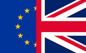
    Brexit blues?

    Mark Bacon added “I am very pleased to have been elected to work with the Board and I look forward to helping the GSA deliver on the Galileo and EGNOS programmes over the coming years.”  However the UK’s decision to leave the EU (Brexit) must make his position rather uncomfortable – and temporary – to say the least.

    The GSA Administrative Board is composed of representatives from each EU Member State, the European Commission, and the EU parliament. The Board meets three times per year to ensure that the Agency performs its tasks correctly. As things stand if the UK is no longer an EU Member State it must lose its representative(s) on the advisory board.

    However, the relationship between the UK and EU space programmes is, of course, subject to the Brexit negotiations. The UK will almost certainly remain a member of the European Space Agency (ESA) as this is a pan-European body not an EU agency, however when it leaves the EU the country will have to renegotiate terms if it wants to continue to participate in the key EU programmes such as Galileo GNSS and Copernicus Earth Observation system.

    The ESA is autonomous from the EU and should not be directly affected by Brexit confirmed Jean Bruston, head of ESA’s EU policy office at a media briefing in mid-September. But “As soon as it [Britain] is leaving the EU it is not participating in these programmes [Galileo / Copernicus] any longer,” he observed.

    In addition, UK-based companies hold contracts worth tens of millions of euros from ESA to supply hardware for the Copernicus and Galileo GNSS. “If nothing changes [and Brexit goes ahead], we would have to stop these contracts,” said Bruston bluntly.

    Of course, Britain could still contribute to Galileo and Copernicus if it negotiated a third-party agreement with the EU, as Norway and Switzerland (both non EU members) have done. The down side is that this may take some time to initiate, let alone complete, and if Britain sticks to its guns on issues such as free movement of people then the likelihood of a successful outcome for the UK is not high.

    In an interview with French media ESA director-general Jan Woerner reinforced Bruston’s views saying that “the UK will remain a member state of ESA, this is very clear” but also continuing “As we are also dealing with European programmes like Copernicus and Galileo, and also the question of UK citizens working on the continent and all these legal issues, we have to take this into account.”

    EU opportunity

    Many in ‘continental Europe’, as we Brits so often condescend to describe our fellow Europeans, will be more than happy to see the U.K. no longer participating in deciding key aspects of EU space and other policy areas.

    It is no coincidence that the European Commission has become much more vocal on plans for a European defence force since the Brits announced their departure. The U.K. has long been opposed to the concept of an ‘EU Army.’ However planning and military cooperation between Member States outside normal NATO channels has been increasing over many years. The small and discreet (so discreet that I didn’t realise the exact location of its HQ in Brussels until the recent terrorist incidents meant burly Belgian paratroopers were stationed outside and I asked them what they were guarding. Has to be said they were not discreet!) has seen its budget frozen for the last five years, but this may now change.

    The interface of EU space and defence policy – in particular ‘dual use’ issues – will also become simpler without the U.K.’s protests. A leaked draft of the upcoming EU Space Policy communication talked directly of dual-use synergies to reinforce security from space, in particular to reduce costs and improve efficiency, and that the next generation of EU GNSS and Copernicus programmes should be designed from the start to be more relevant for security purposes. Defence-related research is also slated for future Horizon 2020 calls.

    The draft policy document also underlines that with EU space programmes becoming fully operational, building stability, trust and confidence in users is a key objective. Current services must be fully deployed and their long-term continuity and evolution assured. This continuity should be driven by user needs and take into consideration the mid-term (hardly mid-term for Galileo!) evaluation of the programmes that should happen in 2017. For Galileo and EGNOS, the document looks to improvements in the current services, including greater robustness and performance, and provision of additional services, such as regional or timing services.

    California dreaming

    So with Brexit what is the U.K.’s GNSS – and space-related – industry and research community to do? Of course many of the UK industrial players are multi-national companies and internal transfer of people and/ or projects will overcome many issues. And bi-lateral collaborative agreements on exchange of talent and ideas between partners can also achieve the same results for smaller companies and research groups. However not having a seat in the policy process and the development of programmes will put ‘UK plc’ at a distinct disadvantage in my opinion.

    But U.K. leaders say that Brexit is an opportunity to be seized and that the U.K. should be looking to sell  goods and services in other global markets than the EU. Which is something most U.K. industry has been doing since trade/ time began. And in my experience U.K. business leaders have always been much more eager to go jump on a plane to the States or Australia than go visit their European neighbours – something to do with our renowned national language skills perhaps?

    Space is no exception – and one that has been shown to be a success in recent times. A helping hand is provided by InnovateUK, the U.K.’s government innovation agency, that is organising its third ‘Space Mission UK’ to the US in November. These are trade and investment missions specifically designed to support U.K. start-up companies to build world-leading space and satellite application businesses.

    Space Mission 1 visited Utah, LA and Silicon Valley in August 2015 and Space Mission 2 landed in Houston in November 2015. Space Mission 3 will visit San Francisco and LA from 5-11 November this year.

    Mission programmes are varied but typically include visits to companies working at the forefront of the sector, networking opportunities with investors and corporate venture people interested in space, visits to incubators, accelerators and technology hubs, and masterclasses on pitch development, business culture and market entry.

    The previous two Space Missions have had immediate impact for the companies involved, including securing over £1 million in investment, and initiating collaborations with major organisations such as NASA and (ironically) ESA, and winning contracts with the UK Ministry of Defence at home.

    GNSS-related companies in previous missions include Arralis who build high-end semiconductor chips but have also been funded to develop novel GNSS antennas, and an exciting data fusion start-up – Gyana – that takes complex inputs from multiple data sources, including satellite, to build simple to understand 3D situational images. The founder of the business, engineering graduate Joyeeta Das, has raised US $1.1m since the mission.

    You can find a complete list of companies who have participated on the previous missions here.

    The selection for Space Mission 3 has closed and I am told there is at least one GNSS applications company that has been chosen to be on the plane in November. Good luck to them all!

    Google emergency LBS upgrade

    E112 is a location-based version of the 112 universal European emergency number, where the telecommunication operator transmits location information to the emergency centre in parallel to the call itself. With more than 70 percent of calls to emergency services coming from mobile phones, getting help fast and efficiently to the caller can be challenging if they don’t know where they are. Now, in a major step forward for implementation, Google has created and rolled out in two European countries (U.K. and Estonia) its Emergency Location Service on Android, with other regions to follow. The feature, when supported by the caller’s network, sends the phone’s location to emergency services when the 112 (or equivalent) emergency number is dialed.

    Emergency Location Service is supported by more than 99 percent of existing Android devices (version 2.3 and above) through Google Play services. The service activates when supported by the mobile network operator or emergency infrastructure provider.

    The new geographical location system claims to identify the source of a mobile phone emergency call to typically within 0.003 square kilometres (less than half the size of a football field) instead of a current average of around 12 square kilometres.

    When an emergency call is made with an enabled Android smartphone, the phone automatically activates its location service and sends its position by text message to the 112 service. This usually takes less than 20 seconds. This text message is not visible on the handset and is not charged for.

    And the first European Galileo-ready smartphone has been launched with the Aquaris X5 Plus smartphone, produced by the Spanish technology company BQ, and based on the Galileo-supported Qualcomm Snapdragon 652 processor with Galileo capability accessible via a software update to be released in Quarter 4 2016.

    U.S.-based Qualcomm announced in June that it was adding support for Galileo across its Snapdragon processor and modern portfolios for smartphone, computing, automotive and IoT applications.

    As well as Galileo capability, the Aquaris X5 Plus is powered by the latest Google Android OS and has all the usual features of a top end smart phone including 16 mega pixel ‘back’ camera and support for 4k video recording with a stabiliser and fingerprint recognition for added security.

    If you want to take the pulse of the GNSS user technology industry and keep up with the latest trends then you’ll need to get your hands on the GSA’s GNSS User Technology Report due out at the beginning of October.

    The 2016 report will be launched on 4 October as part of the Horizon 2020 Space Information Days in Prague. This two-day GSA-hosted event will introduce the third call for GSA-funded Horizon 2020 research and innovation proposals for Galileo and EGNOS.

    The document will take an in-depth look at the latest state-of-the-art GNSS receiver technology, along with providing expert analysis on the various trends that are defining the future global GNSS technology landscape. The report will focus on three key areas: mass market solutions; transport safety and liability-critical solutions; and high precision, timing and asset management solutions.

    Pulsar GNSS for deep space

    The use of pulsars, highly magnetized, rotating neutron star that emits a beam of electromagnetic radiation with a very precise period, have been potential candidates for a deep space navigation system for many years. Now a paper from the U.K.’s National Physical Laboratory (NPL) and the University of Leicester shows that pulsars can be used to obtain position along a particular direction in space to an accuracy of two kilometres in the direction of the pulsar. Furthermore such a technology could operate autonomously and greatly increase the number and capabilities of space missions, the paper claims.

    To calculate their position a space craft would need to carry a small X-ray telescope. The method uses X-rays emitted from pulsars, which can be used to work out the position of a craft in space in 3 dimensions to an accuracy of 30 km at the distance of Neptune. Certain types of pulsar, called ‘millisecond pulsars’, emit pulses of radiation with the regularity and precision of an atomic clock and therefore could be used much like GNSNS in space.

    The paper, published in Experimental Astronomy[1], details simulations undertaken using data, such as the pulsar positions and a craft’s distance from the Sun, for an ESA feasibility study of the concept. The simulations took these data and tested the concept of triangulation by pulsars with current X-ray telescope technology and state-of-the art position, velocity and timing analysis. This generated a list of usable pulsars and measurements of how accurately a small telescope can lock onto these pulsars and calculate a location.

    The key finding was that at a distance of 30 astronomical units – the approximate distance of Neptune from the Earth – an accuracy of 2km or 5km can be calculated in the direction of a particular pulsar (PSR B1937+21) by locking onto the pulsar for ten or one hours respectively and that by locking onto three pulsars, a 3D location with an accuracy of 30km can be calculated.

    This is an improvement on the current navigation methods of the ground-based Deep Space Network (DSN) and European Space Tracking (ESTRACK) network as it could be autonomous with no need for Earth contact for months or years, if an advanced atomic clock is also on the craft. Also ESTRACK and DSN can only track a small number of spacecraft at any one time. It is also possible that the pulsar technique could be quicker.

    Dr Setnam Shemar from NPL commented: “How these [space]craft navigate will in future become a limiting factor to our ambitions. The cost of maintaining current large ground-based communications systems based on radio waves is high and they can only communicate with a small number of craft at a time. Using pulsars as location beacons in space, together with a space atomic clock, allows for autonomy and greater capability in the outer solar system.”

    This simulation uses real-world technology and proves its capabilities for this navigation task. The X-ray telescope can be launched into space due to its low weight and size and it will be flown on a mission to Mercury in 2018. Could we be seeing the emergence of a navigation technology that can enable a new era of space exploration?

    And with that look into the future it is time to say “adios” to this column. From now on my EAGER dispatches will be sprinkled through other GPS World imprints and platforms. I’ll be at the global geospatial fun-fest that is Intergeo in Hamburg in October and sniffing around the first Galileo ‘hackathon’ in Berlin in early November, so I hope to see many of you at those and subsequent Euro-GNSS events in the future.

    A bientot as they say in these parts.

    [1] Towards practical autonomous deep-space navigation using X-Ray pulsar timing’ Shemar, S., Fraser, G., Heil, L. et al. Exp Astron (2016). doi:10.1007/s10686-016-9496-z