Tag: certification

  • Another Orolia ELT receives Cospas-Sarsat certification

    Another Orolia ELT receives Cospas-Sarsat certification

    New-generation aircraft ELT meets new European Union Aviation Safety Agency (EASA) and U.S. Federal Aviation Administration (FAA) requirements

    Photo: Orolia
    Photo: Orolia

    Orolia has received certifications for yet another survival emergency locator transmitter (ELT), the Ultima-S.

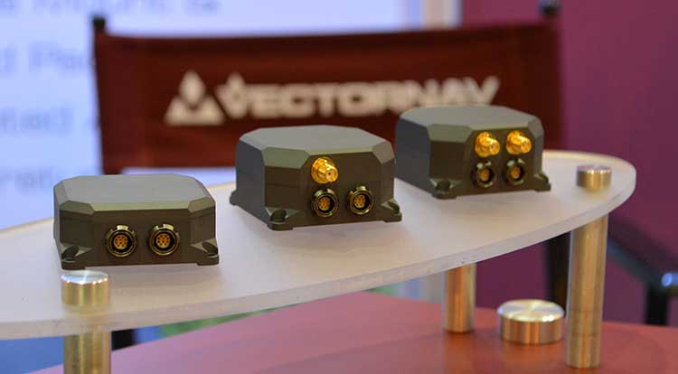
    The news follows Orolia’s announcement that it had received certification for the Ultima-DT model, as well as a personal locator now shipping to the U.S. Army.

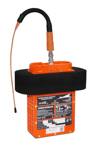
    The Ultima-S is a new generation ELT installed in either the cabins or liferafts of aircraft. It relays accurate aircraft location information to search-and-rescue teams.

    Once activated, a 406-MHz distress signal is transmitted and includes the ELT’s location thanks to the Ultima-S internal GNSS receiver. This built-in GNSS capability increases both probability and speed of detection of the distress signal.

    “With these key certifications for the Ultima-S, Orolia brings a long-awaited solution to the industry,” said Jérôme Ramé, Orolia’s Aviation & Military Product Line Director. “We have developed strong partnerships with several of the leading aircraft manufacturers that will enable operators worldwide to benefit from the Ultima-S for both their linefit and retrofit needs, allowing fleet standardization.”

    The Ultima-S provides free, global coverage service through the dedicated Cospas-Sarsat infrastructure while meeting the highest aviation safety standards. Orolia offers non-rechargeable lithium batteries compliant with the latest FAA and EASA special conditions standards, also known under TSO-C142b/DO227A. The Ultima-S also meets the most recent ELT performance and environmental standards through TSO-C126c.

    “What makes the Ultima-S unique is a new feature called the Return Link Service (RLS),” said Ramé. “Through this capability, the user is automatically notified when the distress signal is detected and located by the Cospas-Sarsat ground infrastructure. The Ultima-S links directly to the European Galileo GNSS satellite constellation, providing the most reliable and timely information for reaching aircraft crew members in distress.”

    In addition to being available on a linefit basis on major aircraft programs, Orolia has launched an exchange program to make retrofit activities easier for airlines, especially those upgrading to safer battery technology.

  • VectorNav tactical series earns MIL-STD and DO-160 certifications

    VectorNav tactical series earns MIL-STD and DO-160 certifications

    VectorNav Technologies’ tactical series line of inertial measurement units (IMUs) and GNSS-aided inertial navigation systems (GNSS/INS) have completed independent testing for MIL-STD-810G, DO-160G, MIL-STD-1275E and MIL-STD-461.

    Completion of the MIL-STD and DO-160 qualification tests proves the robustness of the tactical series to a range of temperature, shock, vibration and other environments, as well as conformance to numerous electrical interface and EMI standards.

    The testing demonstrates an advantage of the tactical series for defense and aerospace applications. Other advantages are the modules’ SWAP-C (size, weight, power and cost) and performance characteristics.

    “There is high demand for dependable, tactical-grade navigation solutions that perform in challenging environmental and operating conditions,” stated VectorNav Director of Sales and Marketing Jakub Maslikowski.

    VectorNav’s tactical series includes the VN-110 IMU/AHRS, the VN-210 GNSS/INS and the VN-310 GNSS-compass aided GNSS/INS.

    VectorNav's new Tactical Series includes the VN-110 IMU/AHRS, the VN-210 GPS/INS and the VN-310 dual-antenna GPS/INS. (Photo: GPS World)
    VectorNav’s new Tactical Series includes the VN-110 IMU/AHRS, the VN-210 GPS/INS and the VN-310 dual-antenna GPS/INS. (Photo: GPS World)

    The products include an onboard tactical-grade IMU (<1˚/hr in-run gyro bias stability), along with VectorNav’s proprietary filtering, INS and GNSS-compass algorithms.

    The products offer 1 to 2 mrad attitude performance in compact, rugged enclosures and include a 10-pin auxiliary port for integration with external real-time kinematic and SAASM-based GNSS receivers, as well as higher-performance IMUs.

    Testing for the MIL-STD and DO-160 standards was performed by independent, certified testing companies in Plano, Texas, and Huntsville, Alabama.

  • Kongsberg Geospatial offers certifiable application for unmanned traffic management

    Kongsberg Geospatial offers certifiable application for unmanned traffic management

    Kongsberg Geospatial’s IRIS UAS situational awareness application now provides a certifiable option to monitor drones and airspace. Kongsberg Geospatial is an Ottawa-based developer of real-time geospatial visualization software.

    The IRIS UAS Airspace Situational Awareness application meets the requirements of the DO-278A Assurance standard for air traffic management systems.

    By anticipating the regulatory requirements for airspace visualization with Unmanned Traffic Management or UTM, the IRIS display will be a regulatory approved component increasing the safety of commercial drone flight operations — especially when operating beyond visual line-of-sight (BVLOS).

    IRIS UAS program director Paige Cutland uses the IRIS UAS airspace situational awareness application to monitor the progress of a drone on a beyond line-of-sight (BVLOS) mission from a portable ground control station set up in a trailer.

    Kongsberg Geospatial has been providing software design assurance to meet the certification requirements for real-time geospatial and spatial awareness technology to support air traffic management, air defense applications and unmanned systems for nearly three decades.

    Their IRIS UAS situational awareness application had its genesis in supporting military UAV flight operations and was developed to help operators safely pilot UAVs in BVLOS operations. It was also used by regional airspace UTM managers to monitor the operations of multiple drones simultaneously.

    The DO-278A standard (Guidelines for Communication, Navigation, Surveillance and Air Traffic Management [CNS/ATM] Systems Software Integrity Assurance) is the primary standard used by certification authorities such as FAA, EASA and Transport Canada to provide the assurance of software contained in non-airborne CNS/ATM systems. Unmanned systems manufacturers that build ground control stations for commercial drone systems, and airports and port authorities that create airspace control systems are anticipated to have to meet this standard when designing and building new systems.

    By developing an airspace awareness application that satisfies this standard, Kongsberg Geospatial has provided a key component for unmanned systems manufacturers, airport operators and port authorities that wish to develop ground-based monitoring systems that are safe and certifiable for commercial operations.

    “Unmanned Traffic Management and safe airspace operations will require certification of technology,” said Ranald McGillis, president of Kongsberg Geospatial. “We believe providing a certifiable airspace application will dramatically increase the safety of unmanned flight operations wherever it’s in use.”

  • USGIF launches universal GEOINT certification program

    The United States Geospatial Intelligence Foundation (USGIF) officially launched its Universal GEOINT Certification Program May 16 during general session at its GEOINT 2016 Symposium. The symposium takes place May 16-19 in Orlando, Florida.

    USGIF’s certification program includes three exams with corresponding certifications: GIS and Analysis Tools (CGP-G); Remote Sensing and Imagery Analysis (CGP-R); and Geospatial Data Management (CGP-D). A fourth competency — data visualization — is incorporated throughout all of the exams.

    Available to U.S. and international GEOINT practitioners across industry, military, academia, and government, the certification program is beneficial to anyone who wants to further their education and training, take the next step in career advancement, or showcase his or her understanding of GEOINT.

    Each of the three exams and subsequent professional certifications are incredibly valuable as standalone credentials. However, GEOINT practitioners who earn and maintain all three USGIF certifications simultaneously will be eligible to apply for USGIF’s overarching Universal GEOINT Professional (UGP) designation.

    USGIF recognized six Universal GEOINT Professionals this morning that achieved the UGP designation during the program’s pilot testing phase. The first UGP recipients are: Talbot Brooks, Stewart Bruce, Chris Johnson, Angel Martinez, Christopher Stahl and Michael Wood.

    Also during the pilot testing phase, 26 individuals achieved the CGP-G certification, 37 earned the CGP-R designation, and 28 achieved CGP-G recognition.

    Parallel with USGIF’s efforts, the National Geospatial-Intelligence Agency (NGA) has created a certification program designed specifically for the U.S. Defense Intelligence Enterprise. USGIF and NGA have agreed upon a plan for reciprocity. The goal between the programs is to achieve transferability through the concept of functional equivalence, which allows hiring officials to agree that more than one certification meets current organizational needs.

    This concept of transportable and transparent professional certification with universal applicability will continue to be paramount to USGIF Membership as well as to the growing global GEOINT Community.

    USGIF has created an independent Certification Governance Board (CGB) to direct certification efforts. The CGB met several times in the lead-up to the official launch of the certification program, and will hold its first annual meeting at the GEOINT Symposium tomorrow, May 17.

    Universal GEOINT Certification Program testing will begin in July.

    Visit usgif.org/certification to learn more.

  • AAGS seeks input on geodetic certification program

    The American Association for Geodetic Surveying (AAGS) has undertaken an effort to explore creating a geodetic certification program. The geodetic certification would provide official recognition that a person has the working knowledge and skills to understand and solve practical problems in applied geodesy.

    The vision is that the geodetic certification program would be similar to other existing certifications, such as the American Society for Photogrammetry and Remote Sensing (ASPRS) Certified Photogrammetrist, the GIS Certification Institute (GISCI) GIS Professional, and the National Society of Professional Surveyors (NSPS) and The Hydrographic Society of America (THSOA) Certified Hydrographer.

    “As geospatial technology continues to advance and gain wider adoption, geodesy is becoming an increasingly important part of the geospatial framework,” said AAGS past president Michael Dennis, RLS, PE. “To that end, we are exploring the concept of creating a program that officially recognizes professionals with a minimum level of geodetic competence.”

    To gain input from industry professionals, AAGS created an online questionnaire about the program and invites all those involved with geospatial technologies to contribute. The questionnaire is available here.

    The questionnaire is intended to serve multiple purposes:

    • Establish an appropriate body of knowledge for applied geodesy
    • Determine the level of support in the geospatial community
    • Identify areas of interest and existing status of geodetic knowledge
    • Provide guidance on creating and prioritizing educational content
    • Show the breadth and depth of the field of geodesy
    • Raise awareness of the proposed program

    The questionnaire also helps lay the foundation for creating a certification program and consists of 50 questions. The first ten are general questions, and the remaining 40 are divided among the eight topic areas listed below.

    1. Geometrical Geodesy and Reference Systems
    2. Map Projections
    3. Physical Geodesy
    4. Astronomic and Celestial Coordinate Systems
    5. Global Navigation Satellite Systems
    6. Statistics and Least Squares
    7. Geodetic Observation Procedures and Practices
    8. Standards, Specifications, and Guidelines

    AAGS is seeking input from a broad cross section of geospatial practitioners, including surveyors, engineers, GIS professionals, photogrammetrists, programmers and any others who use geodetic methods and calculations to combine, manipulate, and analyze spatial data.

    The proposed geodetic certification program is being developed in cooperation with the National Society of Professional Surveyors (NSPS). Participation of other professional geospatial organizations is currently being solicited as part of program development.