Tag: CNAV

  • L2C and Next-Generation Smart PNT Receivers

    L2C and Next-Generation Smart PNT Receivers

    Are you using a legacy-model PNT (position, navigation and timing) receiver or a smart PNT receiver, and why does it matter? Don’t have a clue? Read on! Hint — L2C and CNAV (civilian navigation message format) are the major reason it matters. Yes, it’s all because of L2C, the controversial GPS civilian signal that seems to always be in the news and just keeps getting better the more we learn about it.

    It was just 30 months ago that I penned a column titled 2C or not 2C: An Important Signal Question.

    A couple of weeks ago, Alan Cameron, our esteemed editor in chief — penned a follow-on editorial comprised of excerpts from techies, subject-matter experts and editors, including yours truly, exchanging opinions about the flexibility, sustainability and capability of the GPS L2C signal and all that signal enables.

    I won’t bother to go into the details or history of the L2C signal here, as I did that in excruciating detail 30 months ago. However, let’s consider L2C 30 months on and determine if the landscape has changed.

    What is L2C?

    According to the official U.S. government PNT website, “L2C is the second civilian GPS signal, designed specifically to meet commercial needs.” As it turns out, the military needs L2C as much as the civilian world, but that is a story for another time. When combined with L1 C/A (coarse acquisition signal) in a dual-frequency GNSS receiver, L2C enables ionospheric corrections, a technique that boosts accuracy. Civilians with dual-frequency GPS receivers typically enjoy the same or better accuracy as the military.

    For professional and high-precision users with existing dual-frequency receivers, L2C delivers faster signal acquisition, enhanced reliability and greater operating range. L2C broadcasts at a higher effective power than the legacy L1 C/A signal, making it more jam and interference resistant, plus it’s easier to receive signals under trees and indoors. The U.S. Commerce Department estimates L2C will generate about $6 billion in economic productivity benefits through the year 2030. Considering there are more than four billion GPS users around the world today, the DOC economic benefits number seems rather low.
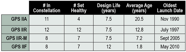
    L2C Status

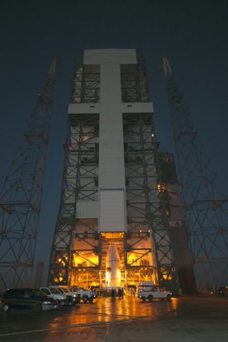
    The first GPS IIR-M (R= Replenishment, M= Modernized with M-code and L2C) satellite featuring L2C launched on Sept. 26, 2005, and is still operational today. Every GPS satellite fielded since then (18 SVs, including SVN 49) has included an L2C transmitter. This equates to 16 operational L2C satellites on orbit and transmitting, with GPS IIF-10 being number 17 when it is fully commissioned. With 17 SVs (GPS satellite vehicles) on orbit, the L2C system is officially near Initial Operating Capability (IOC). With the requisite ground system upgrades, which are in the works, this means that on any given day most users will have at least one or more L2C signals in view. You can be sure manufacturers will be quick to take advantage of the geometry.

    SVN49 in space  (artist’s rendering).  The signal anomaly from SVN 49 alerted researchers to new possibilities in analysis and monitoring.
    LMCO GPS IIRM Satellite Vehicle On Orbit. (Artist’s rendering courtesy of Lockheed Martin)

    Legal Caveats

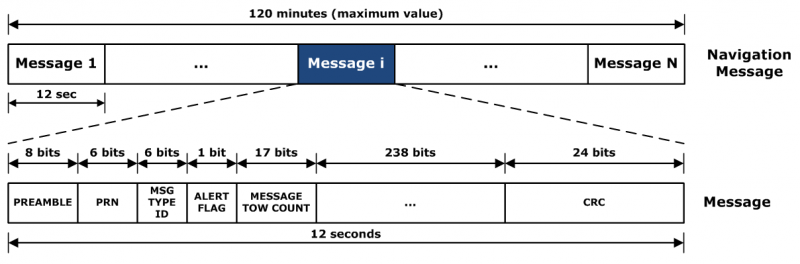
    “In April 2014, the U.S. Air Force began broadcasting civil navigation (CNAV) messages on the L2C and L5C signals. Prior to that time, L2C and L5C provided a default message or Message Type Zero, containing no data. Adding additional CNAV message types required upgrades to the GPS control segment. On Dec. 31, 2014, the Air Force began transmitting CNAV uploads on a daily basis. L2C should continue to be considered pre-operational and should be employed at the user’s own risk.”

    Now the lawyers are happy.

    So What?

    What does this mean for the average user? You might be surprised at the answer. Depending on how technical you are and exactly how you use GPS, it could mean that all your “legacy” GPS receivers are about to become obsolete. Or, depending on the company that builds your receivers and the amount of foresight they built in, it could just mean a few firmware upgrades and new applications.

    Regardless, with the full implementation of L2C GPS signals and navigation messages, GPS will never be the same again. This is not to say your legacy receiver will not work just as efficiently as it does today, and in fact you will probably be able to use it quite effectively for years. But it will not be able to take full advantage of all the capabilities L2C enables without an upgrade, if indeed it is upgradeable.

    Legacy versus Smart

    No matter how much or how little you paid for your GPS/GNSS/PNT receiver, it is essentially — except for a few notable exceptions — a legacy receiver. For example Trimble is ahead of the game as they began producing L2C capable receivers as early as 2003 and are just waiting for the additional L2C messages to be defined. Again, those receivers that are not L2C-ready or capable are what I will classify as a legacy receiver, simply because of all the future capabilities that are missing. Your current PNT receiver may have the potential to be a smart receiver — it may have the technical capability to process far more than it does today. But, unfortunately, essentially almost every receiver, again with a few exceptions, on the market today falls into the “legacy ” category.

    Is My Legacy Device Considered Obsolete?

    Now that I have your attention and have probably riled more than a few GPS device manufacturers, please allow me to explain. In the past, your GNSS/PNT device (for brevity’s sake, I will default to PNT for the rest of the column) has basically performed a simple function. It displayed your position, and perhaps maps and other ancillary data (targets or destinations) after it received, decoded, verified and applied timing signals and a very small number of navigation messages.

    It accomplished this feat typically from a cold start in under 120 seconds. Maybe much less. Recently, I was privileged to view a demonstration of a receiver from a major manufacturer that performed a warm restart in less-than-ideal conditions and displayed a useful position in 1/20th of a second. As amazing as that may be, it is still today classified as a legacy receiver. It accomplished its task; it supplied a useful position both in human and machine language that could be utilized by both. In the past, this was the task your receiver accomplished routinely. With the full implementation of L2C, all that changes and changes drastically. I call it a revolution for PNT, but alas I am frequently given to hyperbole. However, give me a moment and see if you don’t agree.

    I was attracted to a Wall Street Journal headline recently by a company that I know well, since they have an abundance of well-known and multi-talented former military leaders. That company, Accenture, puts it this way: “Change is good. Transformation is even better.” That is exactly where I believe we stand today with L2C. It is a game changer.

    For example, just this week in the WSJ, which I read cover to cover six days a week, I saw stories about Audi vehicles driving autonomously from coast to coast, over 3,000 miles without driver intervention. Contrary to many manufacturers, Audi is quick to credit GPS with a large portion of the proprietary Audi (VW) technology and the capability it enables. There was a story about commercial vehicles, over-the-road diesel trucks that may have even more capabilities than the Audi. Again, with GPS as the prime contributor. The same WSJ story mentioned that, “Some of the features being added to trucks are similar to those in cars, but generally the move to autonomy in commercial and industrial vehicles is far ahead of the autonomous systems offered on most passenger vehicles. Already, mining vehicles and military forklifts are operated without drivers.”

    Amazingly, these capabilities depend greatly on GPS, but exist without the full implementation of the revolution that L2C, CNAV and multiple nav messages will bring.

    L2C CNAV Message Structure.
    L2C CNAV Message Structure.

    L2C Ready

    I have over the past year seen advertisements for PNT devices that proclaim they are L2C ready. I beg to differ, but only because my definition of L2C ready probably varies greatly from that of the devices’ marketing department. Beyond its signal structure, L2C has a new messaging capability.

    As stated earlier, the L2C signal is heads and shoulders above most other GNSS signals in strength, code structure and security. L2C delivers faster signal acquisition, enhanced reliability, and greater operating range. L2C broadcasts at a higher effective power than the legacy L1 C/A signal, making it interference and jam resistant and easier to receive under trees and indoors. These attributes make it a great signal and when you consider the carrier-phase and RTK (real time kinematic) capabilities, which really are real-time today. It is a very appealing signal indeed.

    For precision and timing users, the carrier phase of the L2C signal, non-coded carrier, is 1,000 times more stable than the fully coded L2C signal. The L2C carrier-phase stability will remain unchanged until the semi-codeless transition date of Dec. 31, 2024, per the FRP or Federal Radio Navigation Plan of 2014. Then officially all bets are off, but who knows? That date could be extended.

    However, the real and future strength of the L2C signal structure is hiding in one or more (accurately 255 more, for a total of 256) messages that can be utilized in a myriad of ways and applications. These are messages, nav-messages if you will, that your new or updated PNT device will be able to utilize for who knows how many functions. Just use your imagination. Here are some ideas I have for using the additional L2C messaging capability.

    • Send 250+ other navigation messages, to be defined.
    • Send continuous atmospheric corrections (such as ionospheric) for each two degrees of longitude around the globe or in one degree increments if you consider land mass applications only.
    • John Deere and Trimble as the leading commercial and civil providers of navigation data could appropriate a small fragment of the messages for their global navigation and timing corrections to their agricultural and precision users/customers around the globe.
    • Companies or governments could send nominal navigation or even text-based navigation-related messages to users anywhere an L2C signal can be received.
    • Companies could shut down and render useless receivers from users that have not paid their bills or were abusing the system.
    • Companies could send small firmware updates or notices of larger updates directly to users. Data could include active hyperlinks.
    • Precision, scientific and premium users might have the capability to receive constant correction updates that make their PNT receiver a centimeter or potentially a millimeter level device.
    • Receivers with communications — four billion plus smartphones and other devices with PNT capabilities and built-in communications — could become sensors capable of being sampled at will. These devices have the potential to be considered remote monitoring stations both for PNT and communications purposes. They could report both communications and PNT jamming or interference. They could also help track intentional jammers.

    If you think about it hard enough, you will see that this modest list of capabilities with the proper security either make spoofing an impossibility or without proper security a malicious nightmare.

    I hope by now you catch my drift and have come up with some ideas of your own concerning how the additional 250+ L2C messages could be utilized. We’re unsure how many messages will actually be available or how the messages will be used. The government will, out of operational necessity, require a small number, so right now your guess is as good as mine.

    Keep in mind that L5C and M-code will have the same capabilities on differing frequencies, and different governing bodies will decide how the signals and 750-plus multiple-messaging capabilities are allocated and utilized. That is all hopefully in the near future. How that process unfolds, technically and operationally, will have a great deal to do with how successful and ubiquitous L2C becomes. The process alone will undoubtedly spawn thousands of articles; however, right now we are primarily discussing the necessity for smart receivers to fully utilize the additional L2C messages. For along with all the potential capabilities comes a processing and communications tail that does not exist today, except in a few instances that we can’t go into in this venue.

    Relative

    This is probably a good time to further qualify what I mean by legacy versus smart receivers. Were the appellation “legacy” not already in our vernacular concerning today’s highly functioning devices, it would not be one I would have chosen. However, it is and we are stuck with it. Consider that there are static high-end (read premium quality) single GNSS receivers that “see” more than 50-60 separate GNSS satellite vehicles and processes more than 150 GNSS signals. This does not take into consideration all the augmented and companion signals some of these devices are capable of processing. Many of these devices are very difficult to jam and literally cannot be spoofed, and still today they are legacy receivers in relationship to L2C capabilities.

    However, I am told such high-end receivers are absolutely L2C ready, which may mean the additional L2C messages are ready to be processed and applied, received or rejected, whenever they are properly and officially defined. This brings us to the future definition or next generation smart L2C receiver.

    Smart L2C PNT Receiver

    For the first time a smart PNT L2C capable receiver will have the ability to:

    • Select between GPS only, GPS + GLONASS, or full GNSS mode with ancillary corrections such as WAAS and EGNOS, and work with, process or reject messages, making a decision about some or all the signals it has in view. While there are receivers that accomplish some of these functions today, they do not typically have the option of accepting or rejecting a GPS navigation message if it is properly formatted and verified. L2C smart receivers will — indeed must — at a minimum possess and correctly utilize that capability.
    • Alert users concerning new navigation message(s) and determine automatically or with user input whether the navigation message should be applied immediately, in the near future, put on hold or totally rejected.
    • Alert users to the effect that applying new or multiple navigation messages will have on the current PNT display and possibly the current mission or operation. For example, if you are a precision user, think millimeters for level of accuracy, utilizing PNT to measure tectonic plate movement — you are very interested in relative displacement over time and you may have no desire to apply a multiple nanosecond correction that could move your current measured position several inches or feet. If you are a geocacher, you do not want the coordinates of your latest buried treasure to dynamically change.
    • Determine if the latest valid navigation message(s) apply to your geographic area or, for mobile receivers, your destination, and what effect incorporating the messages will have on your displayed position or ETA.
    • Display a text-based navigation message if it is addressed to your device.
    • Require password(s) for certain actions — be they sensitive, proprietary, classified or of a “cannot undo” nature. Passwords could also be required in the message format before it could be unlocked and applied.
    • Determine and alert users if multiple navigation or device-control messages conflict with organizational or user-defined parameters.
    • Alert users to malicious messages or spoofing attempts.
    • Alert users to GNSS assets that are no longer available or go offline, such as during the two total GLONASS constellation shutdowns when GLONASS signals were not available for several hours. In the case of Apple iPhones, the GLONASS constellation-wide shutdown meant these devices went from multiple GNSS devices to “GPS plus PNT augmentation (WAAS) and other onboard sensors” devices. This is something many users may not care about, but is definitely worth a user-defined parameter for a warning message.
    • The ability to permanently reject a certain type of message by type, source, timeframe, etc.

    By now, I hope you see the trend. You can probably think of many more possibilities for future GNSS or PNT receivers and the necessity for them to be loaded with computing and communications capabilities, especially where L2C is concerned — indeed, where all the CNAV signals and messages are concerned.

    Bottom Line

    The bottom line is L2C is a potentially revolutionary signal for GPS/PNT; it opens incredible opportunities for entrepreneurs, manufacturers and users at a minimum. We now all have some hard and important questions to consider before we purchase our next-generation PNT device or upgrade our legacy device.

    Until next time, happy navigating, and I hope to see everyone at ION GNSS+ in September in Tampa, Fla. Remember, GPS is brought to you courtesy of the United States Air Force.

  • To L2C or Not to L2C? That Is the Operational Question.

    Half of the GPS constellation now transmits the new civil signal, L2C. In a matter of weeks, that number will crest into the majority of the constellation when IIF-10 is set active and operational to users. By the end of the year or early 2016, look for 18 usable satellites transmitting L2C. That could be considered a nominal initial operating capability (IOC), though it is unlikely to be declared as such by the Air Force. We can anticipate a full operating capability (FOC) within five years. Many high-precision GPS receivers currently embody L2C signal processing capability.

    As Oscar Colombo, research scientist at NASA, noted in a recent CANSPACE contributed note, “This seems like a moment to start seriously thinking about using L2C as much as possible.”

    This month’s newsletter presents an amalgam, a panel discussion in virtual print, on several aspects and viewpoints stimulated by his posting,

    Some readers may want to peruse this U.S. government bulletin for a general description of L2C; others who feel sufficiently informed may skip directly two paragraphs down to “Three issues might be in the way of that being a practical proposition.”

    “L2C is the second civilian GPS signal, designed specifically to meet commercial needs. Its name refers to the radio frequency used by the signal (1227 MHz, or L2) and the fact that it is for civilian use. There are also two military signals at the L2 frequency. When combined with L1 C/A in a dual-frequency receiver, L2C enables ionospheric correction, a technique that boosts accuracy. Civilians with dual-frequency GPS receivers enjoy the same accuracy as the military (or better). For professional users with existing dual-frequency operations, L2C delivers faster signal acquisition, enhanced reliability, and greater operating range. L2C broadcasts at a higher effective power than the legacy L1 C/A signal, making it easier to receive under trees and even indoors. The Commerce Department estimates L2C could generate $5.8 billion in economic productivity benefits through the year 2030. The first GPS IIR(M) satellite featuring L2C launched in 2005. Every GPS satellite fielded since then has included an L2C transmitter.”

    Oscar Colombo’s CANSPACE note continues:

    “Three issues might be in the way of that [using L2C as much as possible] being a practical proposition, and I would appreciate comments on some or all of them:

    “(1) The fact that the new L2C navigation code (CNAV) is being transmitted, but flagged as pre-operational by the USAF, indicating that this organization is not yet ready to guarantee its fitness for use.

    “(2) The quarter-wave phase difference with the heritage signal L2.
    This one is important to know when fixing the ambiguities of differential observations (double differences and first order differences between satellites) combining L2C data from IIR-M and IIF satellites with those with only L2 (IIR and IIA). Some high-end commercial receivers correct for this phase difference, some don’t.  The latest RTCM document I’ve seen that touched on this issue came out in 2013 (RTCM Standard 10403.2, Paragraph 3.1.8, Table 3.1-5), and listed the choices , at that time, by nine leading manufacturers on this matter. The list does not include all of present-day manufacturers of high-end receivers, a list that changes over time.

    “(3) There is no proper place for L2C in files in the widely used Rinex 2.11 format.
    In principle, this can be taken care of by using data files in the Rinex 3 format. However, the use of Rinex 3, that has some major departures from 2.11, is not universal yet.

    “Does anyone  know of an up-to-date, reliable and comprehensive list of receiver manufacturers showing those that correct and those that do not correct for the quarter-wave phase shift?”

    GPS World contributing editors Eric Gakstatter (Geospatial Solutions) and Don Jewell (Defense) had a private conversation about the above, which I now make public.

    Don Jewell: “I can address this from a policy and operational perspective but you [Eric] have a better feel for the users perspective.

    “With two more successful IIF launches there will then be 18 L2C SVs broadcasting that signal, and that is considered by the government to be nominal IOC, an initial operating capability. Regardless of where you are on the Earth, shy of 60 deg N and 60 deg S, you should always have at least one or more L2C SVs in view.

    “We are probably looking at 2023 (8 more years) before the L2 carrier phase is in jeopardy of shifting without notice. If indeed that ever happens.

    “So from an operational and providers (HQ AFSPC, 50SW and 2SOPS) perspective, certainly the L2C signal should be useful and reliable. Just not normally guaranteed until FOC or full operational capability is declared, usually with 24 SVs broadcasting L2C. With no premature losses that will be halfway through the GPS III launch schedule ~ 2019-20.

    “Schedules are dynamic and always subject to change of course.”

    [Editor’s note: The L2 carrier isn’t going to go away or shifting to another frequency. What might go away is the P(Y) modulation on the L2 carrier if the DoD considers the P(Y) signals redundant once the M-code is fully embraced. If the P(Y) signal on L2 is no longer transmitted, then civil receivers currently using the P(Y) signal to obtain L2 carrier-phase measurements will no longer be able to do this.]

    Eric Gakstatter replied, “I’ve heard that some manufacturers say they are taking advantage of L2C when there are IIRM or IIFs in view and maybe some of the receivers I’m using are doing so. I’ve not paid attention to it.

    “It could be helpful in areas where users are trying to work in difficult environments such as near and under tree canopy.

    “In the case of RTK, I would think the reference station would have to broadcast L2C data.”

    A CANSPACE reader provided the following useful reference, which although it dates from 2012, still contains much immutable data: “The most recent view on the situation I have with L2C can be found here.”

    This links to the presentation slides from an American Geophysical Union 2012 Fall Meeting paper, “The Effects of L2C Signal Tracking on High-Precision Carrier Phase GPS Positioning: Implication for the Next Generation of GNSS Systems,” by Frederick Blume, Henry Beglund, and Lou Estey of UNAVCO, a non-profit university-governed consortium, facilitates geoscience research and education using geodesy.

    Oscar Colombo and other CANSPACE subscribers have contributed several further notes t the L2C discussion string.  To read them, it’s possible to access the archives here.
    Or you can more simply and elegantly subscribe to CANSPACE; see instructions here.

    Last month, Richard Langley and Oliver Montenbruck jointly communicated the following interesting aspect of the U.S. Federal Radionavigation Plan to CANSPACE readers:

    “in the new version of the FRP is a new phrasing of the earlier statement on guaranteed availability of the P(Y) signal only up to 2020:

    “The [U.S. Government (USG)] commits to maintaining the existing GPS L1 C/A, L1 P(Y), L2C, and L2 P(Y) signal characteristics that enable codeless and semi-codeless GPS access until at least two years after there are 24 operational satellites broadcasting L5. Barring a national security requirement, the USG does not intend to change these signal characteristics before then. Twenty-four satellites broadcasting the L5 signal is estimated to occur in 2024. This will allow for the orderly and systematic transition of users of semi-codeless and codeless receiving equipment to the use of equipment using modernized civil-coded signals. Note that it is expected that 24 operational satellites broadcasting L2C will be available by 2018, enabling transition to that signal at this earlier date. Civilian users of GPS are encouraged to start their planning for transition now.”

    Finally, Richard Langley notes that “I have a student looking into which Precise Point Positioning engines can currently process L2C observables, but his report is not yet available. Also, we are looking into adding an optional L2C processing capability to the University of New Brunswick PPP software, GAPS (GPS Analysis and Positioning Software), but that’s a month or so away.”

    As a postscript, there is a trending discussion at the LinkedIn group, GNSS R&D, Using C\A acquisition products to acquire L2C long code.

  • The System: Celebrating 20 Years of GPS

    The System: Celebrating 20 Years of GPS

    April marks the 20th anniversary of GPS FOC. U.S. Air Force Space Command declared Full Operational Capability (FOC) for the GPS constellation April 27, 1995, signifying the system met all requirements with 24 operational Block II/IIA satellites in their assigned orbital slots and providing both the military Precise Positioning Service (PPS) performance standard and the civil Standard Positioning Service (SPS) performance standard.

    FOC was formally announced on July 17, 1995.

    GPS IIF-9 Launch on March 25

    GPSIIF-launch-ULA-8As this magazine went to press on March 19, the U.S. Air Force’s ninth GPS Block IIF satellite (GPS IIF-9) was being readied for a March 25 launch [since successfully launched]. The satellite was encapsulated in the Delta IV rocket’s 4-meter-diameter nose cone at a processing facility, and moved to the launch pad at Space Launch Complex 37 for mating to its booster inside the mobile service tower.

    Launch is scheduled for March 25 at 2:36 p.m. U.S. Eastern time from Space Launch Complex 37 at Cape Canaveral Air Force Station, Fla. GPS IIF-9 marks the 29th Delta IV launch and the 57th operational GPS satellite to launch on a ULA or heritage launch vehicle.

    CNAV Performance Compares Favorably to Legacy Signals

    A March 5 announcement concerning the new L2C and L5 GPS civil signals states: “CNAV Message Types 10, 11, 30 and 33 are currently transmitted on seven GPS IIR-M (L2C) and eight GPS IIF satellites (L2C and L5). A Modernized Navigation (MODNAV) Tool integrated with the GPS ground control software (Architecture Evolution Plan or AEP) is generating the CNAV data messages. Daily CNAV uploads began December 31, 2014, and the U.S. Air Force reports that signal performance of CNAV matches or slightly outperforms Legacy performance: average user range error (RMS URE) from 25 February – 3 March 2015 was 0.50 m for Legacy and 0.57 m for Modernized; best week for Modernized signals since the broadcast initiated April 2014 was 0.42 m for 6 – 13 January 2015.

    “Users are reminded that these CNAV signals are ‘pre-operational’ and should be used with discretion until they become fully operational; the L5 message is currently set unhealthy,” concluded Rick Hamilton, CGSIC Executive Secretariat, USCG Navigation Center, in a status email to the Civil Global Positioning System Service Interface Committee (CGSIC).

    Galileo Six, Seven, Eight: Lay Them Straight

    The original (in red) and corrected (in blue) orbits of the fifth and sixth Galileo satellites, along with that of the first four satellites (green).
    The original (in red) and corrected (in blue) orbits of the fifth and sixth Galileo satellites, along with that of the first four satellites (green).

    On March 17, some stations participating in the International GNSS Service Multi-GNSS Experiment acquired E1 and E5a signals from Galileo 6 (FOC-FM2, GSAT0202). The satellite is using pseudorandom noise code E14.

    This development follows the successful repositioning of the sixth Galileo satellite into a corrected orbit, which will now allow detailed testing to assess the performance of its navigation payload. A 20-meter-diameter antenna at the European Space Agency’s (ESA’s) Redu center in Belgium will study the strength and shape of the navigation signals at high resolution.

    Launched with the fifth Galileo last August, its initial elongated orbit saw it traveling as high as 25,900 kilometers above Earth and down to a low point of 13,713 kilometers — confusing the Earth sensor used to point its navigation antennas at the ground.

    A recovery plan was devised between ESA’s Galileo team, flight dynamics specialists at ESA’s ESOC operations centre and France’s CNES space agency, as well as satellite operator SpaceOpal and manufacturer OHB. This involved gradually raising the lowest point of the satellites’ orbits more than 3,500 km while also making them more circular.

    The fifth Galileo entered its corrected orbit at the end of November 2014. Both its navigation and search-and-rescue payloads were switched on the following month to begin testing. Now the sixth satellite has reached the same orbit.

    This latest salvage operation began in mid-January and concluded six weeks later, with 14 maneuvers performed in total. Its corrected position is effectively a mirror image of the fifth satellite’s, placing the pair on opposite sides of the planet. The exposure of the two to the harmful Van Allen Belt radiation has been greatly reduced, helping to ensure future reliability.

    The corrected orbit means they will overfly the same location on the ground every 20 days. This compares with a standard Galileo repeat pattern of every 10 days, helping to synchronize their ground tracks with the rest of the constellation.

    “I am very proud of what our teams at ESA and industry have achieved,” said Marco Falcone, head of the Galileo system office. “Our intention was to recover this mission from the very early days after the wrong orbit injection. This is what we are made for at ESA.”

    The decision whether to use the two satellites for navigation and search-and-rescue purposes will be ultimately made by the European Commission, as the system owner, based on the in-orbit test results and the system’s ability to provide navigation data from the improved orbits.

    March 27 Launch Date for Galileo Seven, Eight

    The seventh and eighth Galileo satellites, set for launch together on March 27, were placed onto the Fregat upper stage of their Soyuz ST-B launcher in mid-March. [The satellites have been successfully launched.]

    The Fregat stage will hold the satellites in place during their four-hour flight into orbit 22,300 kilometers above the Earth. Then, at the correct altitude, the two satellites are sprung away in opposing directions.

    The Fregat upper stage was blamed for the  August mis-delivery of Galileo satellites five and six. The root cause of the anomaly producing the wrong orbits was a shortcoming in the system thermal analysis performed during stage design, according to findings by an independent inquiry board.

    The anomaly occurred during the flight of the launcher’s fourth stage, Fregat. It occurred about 35 minutes after liftoff, and was due to a temporary interruption of the joint hydrazine propellant supply to the Fregat thrusters. The interruption in the flow was caused by freezing of the hydrazine, resulting from the proximity of hydrazine and cold helium feed lines, these lines being connected by the same support structure, which acted as a thermal bridge. Ambiguities in the design documents allowed the installation of this type of thermal bridge between the two lines.

    IRNSS Launch Scheduled for March 29

    The launch of the fourth satellite for the Indian Regional Navigation Satellite System, previously scheduled for March 9, was postponed until March 29 at 13:00 UTC, due to the replacement of a faulty telemetry transmitter on the satellite. [The satellite has been successfully launched.]

    IRNSS-1D will be fourth in the seven-spacecraft IRNSS constellation.

    BeiDou, Too, in Late March

    There are indications that the first satellite in the BeiDou Phase 3 expansion may be launched by the end of March [since successfully launched]. Apparently, a BeiDou satellite has been shipped to the Xichang launch site, and tracking ships have left port for the open ocean. Also, a philatelic first day cover for the launch (a common Chinese practice) has been issued with a March 2015 inscription. This is likely a launch of a medium Earth orbit (MEO)satellite.

    Where It All Began for Galileo and EGNOS

    The European Space Agency issued a press information notice on June 11, 1995 — in the same timeframe as the GPS FOC announcement noted on the previous page — titled “Europe’s Contribution to a Navigation Satellite System.”

    “The European Commission, the European Space Agency (ESA), and the civil aviation organisation EUROCONTROL have agreed to cooperate on a joint programme).  The European Satellite Navigation (ESN) Action Programme, elements of which are GNSS-1 [First Generation Global Navigation Satellite System] and GNSS-2, is planned to run for five years (from mid-1995 to mid-2000) with a budget of the order of 150 million euros.

    National aviation authorities and the parties involved in the action programme see Europe’s commitment to satellite navigation as being of strategic significance for the future.

    “The main objective of the programme is to develop technologies that will ensure that data from the two existing Global Navigation Satellite Systems — the United States’ GPS and Russia’s GLONASS — which are both under military control, will also be available for civil use on a reliable basis and will provide the requisite precision.  In parallel, studies will be conducted in order to make preparations for a second generation satellite-navigation and positioning system (GNSS-2), to be deployed as from 2005.

    “In the first phase (GNSS-1), ESA’s contribution to the joint action programme will be EGNOS [European Geostationary Navigation Overlay Service].  Satellites stationed in geostationary orbit at an altitude of about 36,000 km will relay to aircraft, shipping or road vehicles information that will enable the recipients to determine their actual positions with greater precision than is possible by using GPS/GLONASS data alone.  Civil users of those systems receive artificially degraded data deviating by about 100 metres.  EGNOS, will enable in particular, to increase the number of satellites that can be seen by a given user within the geostationary broadcast area.

    “Around the period 2005–2008, after completing a trial period, the new system is due to be used as sole means.” 

    Galileo, Previously GNSS-2

    “It is planned to develop GNSS-2 in the period between 2005 and 2020, building on experience acquired under GNSS-1.  From the technical viewpoint, the second generation will be a considerable improvement on the first in terms of reliability, precision and availability. 

    “However, if Europe were to confine itself to developing the relevant technologies, its industry would have only a very slim chance of being involved in the construction of the satellites for the system or in the control and user segments for a second-generation civil system (GNSS-2). Given that U.S. and Russian firms are the current leaders in this area, it is necessary for strategic reasons for Europe to carry out a comprehensive development and demonstration programme as it must be able to prove it has the requisite capabilities before GNSS-2 becomes operational, which, in the experts’ opinion, will be from 2005.

    “The time schedule foreseen for the different steps can be summarised as follows:

    • GNSS-1 mission analysis and definition studies: mid-1995 to mid-1996
    • European GNSS-1 pre-operational mission (task 1): to end 1997. Development of the geostationary network, following the Inmarsat III launch and first ranging demonstration phase
    • GNSS-1 (task 2): 1996 to end 1998. In parallel to the development of the network, the Ground Integrity Channel will be set up, followed by a second demonstration phase
    • GNSS-1 (task 3): 1997 to early 2000. Wide Area Differential service for precision approaches to be set up and tested
    • Introduction of GNSS-1 as sole means: 2000/2003.”

    GPS World is indebted to Richard Langley’s CANSPACE archive of historical documents for this note of interest.

  • CNAV Performance ‘Matches or Slightly Outperforms’ Legacy Signals

    CNAV_Performance Chart_10_Mar_2015_public

    A quarterly meeting of the U.S. GPS Program’s interagency Civil Navigation Signals (CNAV) Tiger Team on March 5 focused on the new L2C and L5 GPS civil signals. “CNAV Message Types 10, 11, 30 and 33 are currently transmitted on seven GPS IIR-M (L2C) and eight GPS IIF satellites (L2C and L5),” wrote Rick Hamilton, CGSIC Executive Secretariat, USCG Navigation Center, in a status email to the Civil Global Positioning System Service Interface Committee (CGSIC).

    “A Modernized Navigation (MODNAV) Tool integrated with the GPS ground control software (Architecture Evolution Plan or AEP) is generating the CNAV data messages,” Hamilton wrote. “Daily CNAV uploads began December 31, 2014, and the U.S. Air Force reports that signal performance of CNAV matches or slightly outperforms Legacy performance: average user range error (RMS URE) from 25 February – 3 March 2015 was 0.50 m for Legacy and 0.57 m for Modernized; best week for Modernized signals since the broadcast initiated April 2014 was 0.42 m for 6 – 13 January 2015.

    The graph above, from the Coast Guard Navigation Center website, illustrates the CNAV performance.

    Users are reminded that these CNAV signals are ‘pre-operational’ and should be used with discretion until they become fully operational; the L5 message is currently set unhealthy,” Hamilton concluded.

  • CNAV Messages Now Transmitted Daily

    News courtesy of CANSPACE Listserv.


    Starting December 31, 2014, the Air Force 2nd Space Operations Squadron began transmitting daily CNAV uploads.

    The CNAV signals should continue to be considered pre-operational and should be employed at the user’s own risk.

  • Directions 2015: What It Takes to Make a Gold Standard

    Directions 2015: What It Takes to Make a Gold Standard

    GPS-directions-CooleyBy Colonel William T. “Bill” Cooley, U.S. Air Force, Director, Global Positioning System

    Last year in my “Directions” article, I emphasized the commitment made by the U.S. government to ensure GPS signals are available to all users, and I shared some of our excitement in the GPS Directorate regarding the modernized capabilities we are developing and fielding. This year I’d like to share with you progress we’ve made in the past 12 months, provide an update on the modernization initiatives, and challenge civil users and receiver companies to innovate and accelerate these modernized capabilities for users worldwide.

    This past year has been productive for the GPS program. The most visible progress was the addition of four new Boeing-built GPS IIF satellites to the GPS constellation, bringing the total number of available satellites from 36 to 39 (SVN-33 was safely disposed in October 2014, or the number would be 40). These additions also reduced the average age of the satellites on orbit from 11.1 to 10.3 years. This year’s GPS launch tempo had not been matched since the early 1990s! Table 1 lists the current satellites in the constellation by block.

    GPS-table-Directions
    TABLE 1. GPS constellation as of October 31, 2014.

    Perhaps the most exciting aspect of the GPS satellite constellation is the ever-improving performance. As I mentioned last year, the 2008 Standard Positioning Service (SPS) Performance Standard, issued by the Office of the Secretary of Defense, codifies our commitment to civil users. Among other attributes that make GPS the “gold standard” for positioning, navigation, and timing (PNT), the SPS requires a signal-in-space (SIS) user range error (URE) of 4.0 meters or less for every healthy satellite. The SIS URE is the difference between a GPS satellite’s navigation message (for example, ephemeris data and satellite clock correction data) versus the truth (for example, satellite transmit antenna location and satellite clock offset from GPS time). While the commitment of the U.S. government is four meters or less, the actual average performance over the past year has been 0.68 meters and in the past quarter has been an impressive 0.63 meters!

    While this is admirable, continued modernization efforts will allow us even better performance. A significant contributor to the errors experienced by GPS receivers are ionospheric delays that can be eliminated only with knowing the characteristics of the ionosphere (free electron density in the region roughly 100-1,000 kilometers above the Earth’s surface) or by using two signals at different known frequencies. While systems like Federal Aviation Administration Wide Area Augmentation System (WAAS) and the U.S. Coast Guard National Differential GPS (NDGPS) provide a modeled approximation of the ionosphere, the new L2C and L5 civil signals on the GPS IIR-M, GPS IIF, and soon-to-launch GPS III satellites enable GPS receivers to directly measure and eliminate the ionospheric delays altogether — thereby delivering on the GPS modernization program first announced in 1999. These new signals began pre-operational Civil Navigation (CNAV) message broadcast on 28 April 2014 (with the L2C signal set “healthy” and L5 set “unhealthy” until sufficient monitoring capability is established).

    With CNAV now on the air, civil users should take advantage of it. My challenge to commercial receiver companies and innovators is to incorporate the modernized signals in future receivers and continue to improve user experience and GPS performance. Currently 14 L2C-broadcasting satellites are in the constellation, and by early 2016 we expect to have 19 on-orbit and transmitting L2C (7 GPS IIR-Ms and 12 GPS IIFs). GPS modernization is well on its way from a signal-in-space perspective; receiver manufacturers and innovators must bring new, improved products and solutions to users.

    Less visible but real progress modernizing the GPS Enterprise is underway with the next generation of GPS satellites, ground control, and user equipment segments. The first GPS III satellite and the newly developed navigation payload have been delayed approximately two years from the original planned delivery of the completed GPS III satellite of October 2014. But in September of this year, the GPS III navigation payload was shipped from Exelis (the payload subcontractor) in Clifton, New Jersey, to Lockheed Martin’s (GPS III prime contractor) facility in Waterton, Colorado. There, it completed the payload-level thermal vacuum testing at the end of October, a key step toward payload and eventually satellite vehicle delivery. The first GPS III satellite is now 87% complete and the program is making solid progress.

    The GPS Next-Generation Operational Control System (OCX), with Raytheon as the prime contractor, experienced significant challenges in development but can also claim measurable progress this year. Complex cyber-security requirements and their implementation drove a significant number of these challenges, but are essential to provide civil and military GPS users with a secure and resilient command and control system. These and other challenges resulted in significant cost and schedule overruns and a two-year delay to the program, which drove an update to the development plan. The revised OCX plan reflects the complexity of implementing these unique cyber requirements and accounts for planned improvements to Raytheon’s systems engineering and software development approach. The plan establishes a schedule meeting GPS III’s projected first-launch date.

    Despite its challenges, OCX development completed four end-to-end space-to-ground launch readiness exercises with GPS III, as well as entered the formal integration and test phase. The new monitoring station receivers are entering qualification test, and the first production receiver is on track to be delivered in spring of 2015. OCX is on track to provide robust PNT services, improvements in URE accuracy, enable access to new military and civil signals, and provide cyber security for the GPS ground control.

    Our development of Military GPS User Equipment (MGUE) is another area where we have made important strides this past year. We started the year by developing a commercial market-based acquisition approach that will accelerate delivery of MGUE systems by years. In this effort, we want to establish a race to a certified marketplace where the U.S. government serves as the race official while our industry partners set their own pace to deliver capability. Our goal is to increase speed of delivery to the warfighter while capitalizing on industry’s ability to innovate.

    Our MGUE team of government and industry partners (Rockwell Collins, Raytheon, and L3) successfully completed major system design reviews demonstrating a readiness to define the process of security and compatibility certification. Additionally, the team participated in the GYPSY Juliett multi-service, multi-nation PNT demonstration hosted by the U.S. Strategic Command this past summer. While we battled the elements through two hurricanes, the team successfully demonstrated the capability of M-Code receiver cards in an operational demonstration. Our goal is to enable full operational testing with four lead platforms in summer 2016.

    While many risks and challenges to GPS modernization still lie ahead of us, the persistent effort by the GPS team has produced important progress in 2014 across the space, ground, and user equipment segments.

    A civilian GPS user recently thanked me for providing the incredibly useful utility free to everyone around the globe. Although my impulsive response was to say simply, “You’re welcome,” I’d like to provide a more thoughtful and thorough reply that recognizes those responsible for GPS.

    There are two key groups to thank for GPS: the first is the men and women across the United States government and industry who develop, field, and operate the GPS Enterprise. Among this group are satellite factory technicians, software engineers improving the ground segment, receiver designers, program office engineers, and satellite operators continuously monitoring the constellation, updating each GPS satellite’s clock correction and ephemeris data 24/7. This team works with an unwavering passion for this mission that inspires me every day.

    The second group responsible for GPS is the American taxpayer who, through Congress, funds the GPS Enterprise every year.  The U.S. financial commitment to GPS is not just for U.S. security or the well documented positive impact GPS has on the American economy, but for the benefit of the entire world as a global utility. GPS is the gold standard for PNT because American taxpayers continuously provide fiscal support so the GPS Enterprise’s men and women can design, produce, field, and maintain the global utility that we all have come to depend on. 

    Thank you for supporting this enterprise, and know that the GPS team works hard to ensure those resources are spent wisely to provide continuously improving, predictable, and dependable performance from the Global Positioning System.


    Colonel William T. Cooley is director, Global Positioning Systems (GPS) Directorate, Space and Missile Systems Center, Air Force Space Command, Los Angeles Air Force Base, California.

  • Latest Words from the Acquisition Guru  of the World’s Gold Standard for PNT

    Latest Words from the Acquisition Guru of the World’s Gold Standard for PNT

    Col. William Cooley, Director, U.S.A.F. Global Positioning Systems Directorate.
    Col. William Cooley, Director, U.S.A.F. Global Positioning Systems Directorate.

    Colonel William “Wild Bill” Cooley, director of the GPS Directorate at Space and Missile Systems Center, discusses CNAV signals, GPS IIF launches, and the OCX with Defense Editor Don Jewell.

    There is probably no busier United States Air Force officer than Colonel William “Wild Bill” Cooley, Ph.D., the director of the GPS Directorate at Space and Missile Systems Center (SMC), Air Force Space Command (AFSPC), Los Angeles AFB, California. He is the driving force for all things dealing with acquisition and development for GPS. Currently, he is juggling so many objects, it is amazing that he is not totally overwhelmed. Consider the issues with the Next-Generation Operational Control System (OCX), GPS IIF, GPS III, and military government user equipment (MGUE), plus a plethora of classified endeavors we can’t even discuss here. He is one busy man, but even with all that, he found time to sit down and answer a few questions in an effort to bring us all up to speed on GPS and PNT.

    Don Jewell (DJ): One of the hot topics at all the symposia lately, here and abroad, has been the broadcasting of additional civilian navigation signals and messages. The U.S. Department of Transportation (DOT) originally objected and sent a strongly worded and probably unadvisable letter to General Shelton (AFSPC/CC) on the matter, but sanity prevailed, and the GPS navigation signals on L2C- and L5C-capable satellites began broadcasting with full navigation messages on April 28. However, we understand DOT still insists some restrictions be put in place for the L5C signal. Can you provide us with an update and a status on that program? Plus, what can users expect in the way of improved accuracy and signal availability?

    Colonel “Wild Bill” William Cooley (WBC): As of April 28, the civil navigation message (CNAV) broadcast was implemented on all operational GPS satellites capable of transmitting the L2C and L5 signals. Currently, seven GPS IIR-M satellites broadcast L2C, and six GPS IIF satellites broadcast L2C and L5. On average, users may expect at least one L2C-broadcasting satellite to be in view at all times.

    The CNAV message content now includes the minimum message set needed to support the positioning, navigation, and timing mission, namely Broadcast Message Types (MT) 10, 11, 30, and 33, which contain information about the satellites’ position, clock, health, and corrections, in lieu of the previously transmitted MT-0 placeholder or default message.

    The Air Force intends to broadcast L2C messages with the health bit set healthy and L5 messages with the health bits set unhealthy until sufficient monitoring capabilities are available for the L5 signal. We expect the accuracy to be slightly less than the Legacy Navigation Message (LNAV) because we are only updating the satellites two times each week. The accuracy should improve to be slightly better than LNAV beginning this December, when we begin updating the CNAV message on each satellite daily.

    DJ: The M-code (military code) and MNAV (military navigation) signals are also being broadcast on M-code-capable satellites. So, the same questions apply: what can our warfighters and government users expect as far as M-code availability and accuracy? What can you say about the multiple messaging capabilities both on the civilian and military (CNAV and MNAV) signals?

    WBC: Like the civil CNAV message, the modernized military-data message MNAV will enable military users to take advantage of all of the performance improvements offered by a modernized military signal. We can expect continued accuracy improvements as newer satellites replace aging satellites.
    MNAV broadcast testing will continue occasionally in support of developmental test events for the next-generation military GPS receiver cards.

    DJ: I know we can get in sensitive territory here in a hurry, but since we are discussing the military signals, can you give us an update on the long-running MGUE and M-code program? When can government users expect to see an actual signal and a receiver with M-code chips and/or modules that utilize the military only signals? Plus — and here’s where we have to be careful — what can you say about the security, availability, and accuracy of the military signal?

    WBC: The M-code-capable military receiver (MGUE) modules in development have successfully acquired and tracked M-code during live-sky tests, and we have many more tests scheduled. MGUE is expected to begin fielding by 2017, at which point at least 18 M-code-capable GPS satellites are expected to be on orbit, providing global four-in-view coverage of full M-code capabilities.

    In the meantime, the most recent GPS IIF satellite launches have raised the total number of M-code-capable modernized GPS spacecraft to 14 (seven GPS IIR-M and seven GPS IIF). This provides four or more M-code satellites in view globally at least 50 percent of the time, and at least one M-code satellite in view continuously. This increasing M-code satellite signal coverage will enable effective, realistic, developmental and operational testing of MGUE receivers.

    The new GPS III block of satellites will provide an M-code signal with greater security, and higher power, comparable availability, and accuracy when compared with the GPS IIF satellites, allowing users to operate closer to jammers and under trees, as well as with greater resistance to jamming and spoofing. Also OCX will offer significantly improved crypto protection and cyber security.

    DJ: Recently, the U.S. Air Force successfully launched the fifth, sixth, and seventh SVs in the GPS IIF family of satellites in less than seven months. Quite a feat! Congratulations are in order for that milestone. However, in the past, the checkout times averaged approximately 30 days. In fact, speed in initializing the IIF SVs and declaring them operational seemed to be an unofficial goal. On GPS IIF-5, however, the rapid checkout timelines have been extended considerably. Can you enlighten us concerning the checkout program and what the government hopes to achieve?

    WBC: There are three key dates with regard to checkout timelines: completion of on-orbit checkout, the transfer of Satellite Control Authority (SCA), and the Operational Acceptance of the vehicle. Measured from launch, the nominal on-orbit checkout timeline is 21 days. The nominal checkout for SCA transfer is 28 days. For the IIF-5 mission, the on-orbit checkout occurred in six days and the SCA in 11 days, a record for the IIF program!

    The operational acceptance was completed 60 days later, following an on-orbit observation validating a requirement to see if the vehicle works as expected without receiving any commands from the ground segment in that time period.

    This may explain the perceived extended checkout, which is in reality a delayed operational acceptance.
    The average time to SCA transfer for the first four vehicles is 42 days. The average is inflated due to a long checkout of the first GPS IIF space vehicle, which took 88 days. From IIF-2 to the present, the average SCA transfer time has been 21 days.

    Using SCA transfer time makes the most sense, because that is the time it took the SPO to go through the entire process (to include meetings and documentation) to hand over the vehicle.

    DJ: Can you give us a status update on the entire GPS IIF family of satellites? How are the SVs faring in orbit, and are the clocks proving to be as stable and accurate as forecast?

    WBC: The first seven of 12 GPS IIF satellites are currently on-orbit and meeting all mission requirements. Of the remaining satellites, one is being prepared for launch in October 2014, one is being prepared for shipment to Cape Canaveral AFS, two are in storage, and one is completing production. The oldest satellite is now four years old. The legacy GPS satellites have remained operational well past their design lives, demonstrating the high-quality engineering and mission-assurance practices used on this program. The clocks are improving the overall accuracy of the constellation with the best-ever day (measured in Signal-in-Space User Range Error) in June 2013 of 46.6 centimeters and the best week in April 2014 of 64.6 centimeters.

    DJ: What exactly do the IIFs mean to the GPS modernization program, for the average user and for the GPS constellation and program as a whole?

    WBC: The 12 Boeing-built GPS IIF satellites will provide improved signals that will enhance the precise global positioning, navigation, and timing (PNT) services supporting both the warfighter and the growing civilian needs of our global economy. The next-generation satellites will provide improved accuracy through advanced atomic clocks, a longer design life than previous GPS satellites, and a new operational third civil signal (L5) that benefits commercial aviation and safety-of-life applications. It will also continue to deploy the modernized capabilities that began with the modernized GPS IIR satellites, including a more robust military signal.

    The anomalies that we have seen on orbit have been resolved either through rework at the factory or through modifications in flight software.

    av_gpsiif7_l1382201472731AM63
    GPS IIF Launch. The seventh of the follow-on generation, rising August 1.

    DJ: Bill, that’s comforting, but what about the clocks on the IIF SVs? There were serious problems with the Cesium clocks on the first couple of launches. Are the operators now able to utilize or activate either the Rubidium or the Cesium atomic reference systems?

    WBC: Don, the answer is yes. The system has triple redundancy with two Rubidium frequency standard clocks and one Cesium frequency standard.

    DJ: What about signal strength and stability on the IIF birds?

    WBC: In addition to an increased number of signals, GPS IIF provides more than the legacy power levels, and all signals on GPS IIF meet stability requirements. For reference, the GPS IIR-M series introduced one new L1 and two new L2 signals, while GPS IIF introduced the new L5 signal. All of these signals are part of the GPS IIF navigation payload and provide information including GPS date and time, satellite health, satellite ephemeris (for individual satellite positioning), and almanac information (for information on other satellites in the constellation).

    The L1 frequency carries the L1 C/A code for civil users, and the L1 P (Y) code and L1 M-code for military users. The L2 frequency carries the first modernized civil signal, L2C, and the L2 P (Y) code and L2 M-code for military users. Finally, the L5 frequency carries the newest modernized civil signal.

    Modernized GPS civil signals provide dual-frequency signals to all GPS users, enabling ionospheric corrections that greatly improve the accuracy. The new L5 signal will be used for safety-of-life applications, including aviation. In addition to an increased number of signals, GPS IIF provides more than the legacy power levels, and all signals on GPS IIF meet stability requirements.

    DJ: Let’s move to the ground segment. OCX, the next-generation GPS Command and Control (C2) system, has literally moved to the right on the schedule timeline for every month it has been in existence since it was awarded in 2010. The end date just keeps getting farther and farther away. OCX is also currently exceeding the original contract budget by a large margin.

    What’s the problem? Is OCX more difficult or complicated than originally planned? Is there any good news to report to users on OCX? What can users expect in the future?

    Just so our readers know, just what is it that OCX brings to the GPS arena that cannot be provided by the current Architecture Evolution Plan (AEP) C2 system? Why do we need OCX? And in your opinion is it still a viable option? Are there contingency plans?

    My apologies — that is about eight questions in one, but hopefully you can bring us up to speed on OCX.

    WBC: Actually, the primary drivers of schedule delays for OCX are related to:

    • issues with the integration and testing of Block 0 on the cyber-hardened infrastructure; and
    • the concurrent systems engineering approach for Block 1 and Block 2, which drove a high rate of rework and inefficient staffing.

    The OCX program is a pathfinder for many of the U.S. Air Force’s and Department of Defense’s most rigorous Information Assurance (IA) and Cyber Security requirements, which have turned out to be more complex to implement than anticipated.

    OCX is a challenged program, but there is progress to report. Raytheon completed a hardware compatibility and integration test with the non-flight test bed of the Lockheed Martin GPS III space vehicle. This test validated the network infrastructure’s ability to communicate between the Lockheed Martin Launch and Checkout Capability and the Raytheon Launch and Checkout System, sending commands to the full-sized, functional satellite prototype test bed.

    In addition, Raytheon and Lockheed Martin completed the third of five planned launch and early orbit exercises to demonstrate launch readiness. This exercise used new installments of the Raytheon OCX software and network infrastructure to demonstrate space-ground communications for initial acquisition, orbit-raising maneuver planning and execution, and basic anomaly detection and resolution.

    Another recent accomplishment was the merging of the Cyber Security hardware and software baseline with the Block 0, Launch and Checkout System, mission applications. The completion of this merge allowed the program to enter formal integration and test activities, which are ongoing.

    The full capabilities of OCX provide more than a dozen new capabilities for the GPS mission. OCX enables the full capabilities of the modernized navigation signals: adding L2C and L5 for civil users, M-code secure signal for military users, an internationally compatible L1C, as well as worldwide monitoring of these modern signals for quality and integrity.

    OCX enables operation of the new GPS III satellites. As we discussed previously, OCX will provide the USAF’s most rigorous cyber-security capabilities, built in from the OCX foundation.

    Raytheon just completed implementation of a program re-plan, which implemented lessons learned to date to correct many of the development challenges encountered, and created a lower risk schedule for delivery. With these changes, the program remains a viable and important component of the modernized GPS enterprise.

    DJ: With that in mind, when do you currently plan on having the first GPS III OCX-controlled launch? Original schedules called for a late 2014 date, then it was 2015, and now we are hearing 2016 or as late as 2018 for OCX. Are there viable alternatives, and if so, can you tell us what they are and if they are being pursued?

    WBC: OCX and GPS III are synchronized to support launch of the first vehicle in the second half of 2016, conditioned upon launch manifest availability. Contingency plans are being developed, but will only be implemented if warranted by the risk.

    DJ: Now, Bill, I am not asking you to blow your own horn here, but frankly we have heard nothing but good reports from SMC and the GPS Directorate since you arrived about 14 months ago. That is a short period of time, but evidently you have made your presence felt and have had a major impact on the GPS program overall. What have you done differently that seems to work so well? To what do you ascribe your success so far?

    WBC: Thank you, Don. I’m very happy to hear the reports are positive, but the credit goes to the men and women of the GPS Directorate, our federally funded Research and Development Center personnel, and our contractors. My job is to continually assess the challenges and barriers that slow modernization. I help resolve the challenges or get additional resources if needed to enable the team to accomplish their important mission.

    I am incredibly fortunate in that the GPS team is passionate about our mission to maintain the Gold Standard for position, navigation, and timing (PNT) for the world. The entire directorate understands the critical role we play for civilian and military users worldwide, and that knowledge motivates and energizes us every day!

    I’m the luckiest colonel in the Air Force because I get to work alongside this terrific team of government and contractor professionals on one of the most important missions in the U.S. Air Force.

    DJ: Obviously you are proud of your team, and you know what it means to be a great leader. In closing, do you have any final comments?

    WBC: Don, just that the GPS Directorate and our contractor team, along with our partners at the 2nd Space Operations Squadron (2SOPS) who fly the GPS constellation 24/7, take our job seriously and understand the important mission we have: to provide reliable and precise position, navigation, and timing services for America’s warfighters, our allies, and civilian users around the globe. GPS is the Gold Standard for space-based PNT today, and we are modernizing to ensure GPS is the Gold Standard for the future.

  • The System: Sixth GPS IIF Launched into Orbit

    The System: Sixth GPS IIF Launched into Orbit

    Photo credit: United Launch Alliance.
    Photo credit: United Launch Alliance.

    A sixth GPS IIF satellite was launched aboard a United Launch Alliance Delta 4 rocket from Cape Canaveral at 8:08 p.m. EDT May 16.

    The satellite, designated GPS IIF-6 and built by Boeing, is one of the next-generation GPS satellites, incorporating improvements to provide greater accuracy, increased signals, and enhanced performance for users.

    According to Boeing, each GPS IIF satellite has greater navigational accuracy through improvements in atomic clock technology and a new civilian L5 signal to aid commercial aviation and search and rescue operations.
    Interestingly, the rocket is the first to be tracked via GPS instead of by radar.

    United Launch Alliance’s Atlas and Delta rockets are transitioning to GPS metric tracking for range safety functions, which protect the public and property should a launch vehicle veer off course. The move is a money-saving upgrade to the military’s aging range infrastructure.

    A special avionics system on the launcher transmitted the location. For decades, most rockets launching from Cape Canaveral, Florida, and Vandenberg Air Force Base, California, have been tracked by C-band radar.

    Two more GPS IIF satellites are scheduled to launch before the end of the year.

    Galileo FOC Satellites Reach Spaceport

    Galileo’s first two full operational capability (FOC) satellites arrived in Kourou, French Guiana, on May 7, in preparation for launch this summer.

    Manufactured by OHB in Bremen, Germany, with navigation payloads contributed by Surrey Satellite Technology Ltd. in Guildford, UK, these satellites — the first of 22 full-capability models — had spent several months at ESA’s Technical Centre, ESTEC, in Noordwijk, the Netherlands, where they underwent exhaustive testing in simulated space conditions.

    The Galileo satellites are named for the children who won a painting competition organized by the European Commission in 2011. Doresa and Milena, the first two FOC satellites, will be launched together aboard a Soyuz rocket, joining the four Galileos already in orbit. Adam, the third Galileo FOC satellite, is now undergoing testing under space conditions at ESTEC. Anastacia, the fourth Galileo FOC satellite, will begin final testing at OHB in Bremen before being shipped to ESTEC.

    “A steady stream of satellites is foreseen, coming from OHB to ESTEC for acceptance testing and then on to French Guiana,” said an ESA official.

    GPS World reported in its March enewsletter EAGER that Galileo may have already fallen off its planned three-launch schedule for 2014.

    Arianespace is already facing an exceptionally crowded launch manifest in 2014. A well-informed source opined, “If one were to hazard a guess, here is the most likely scenario: O3b  arrives ready for launch several weeks ahead of Galileo and secures the June launch. Galileo moves to August and is promised a second launch in the autumn. O3b’s planned second launch in 2014 is moved to early 2015, as is the planned third launch of Galileo.

    “The effect of these schedule slips on the cost of the Galileo program, which is about a year late — cost overruns that Tajani has vowed will not be paid by the commission — is a subject for another day.”

    New Loran at 5 Meters

    the red track  is based on raw eLoran data without any corrections. The transparent blue line is made by GPS-RTK and is widened to 10 meters, giving the required ± 5-meter limits of eDLoran. The white line is output from the eDLoran receiver, which stays within the borders of the 10-meter-wide transparent blue line.
    The red track is based on raw eLoran data without any corrections. The transparent blue line is made by GPS-RTK and is widened to 10 meters, giving the required ± 5-meter limits of eDLoran. The white line is output from the eDLoran receiver, which stays within the borders of the 10-meter-wide transparent blue line.

    Dutch consultants Reelektronika showed results from a prototype enhanced differential Loran (eDLoran) system, extensively tested in the Europort (Rotterdam) area, at the European Navigation Conference held in April. The tests achieved accuracies of 5 meters. A full technical article describing the equipment, methodology, and test results will appear in the July issue of GPS World.

    Harbor pilots require accuracies of 5 meters and some form of robustness or back-up for GNSS systems in case of jamming, unintentional interference, system failure, or other disruption.

    The current eLoran system cannot get better than 10-meter accuracy. The new eDLoran opens up new possibilities for multiple applications:

    • Installing eDLoran reference stations is fast, simple, and cost effective.
    • As there is no data channel bandwidth limitation, multiple reference stations can be installed, which offers increased reliability and makes the system more robust against terrorism and lightning damage.
    • A single or multiple eDLoran servers can be installed in a protected area. There is hardly a practical limit in the number of differential reference stations to serve.

    CNAV on L2C and L5 Initiated

    On April 28, U.S. Air Force Space Command began broadcasting civil navigation (CNAV) messages on all operational GPS satellites capable of transmitting the L2C and L5 signals. L2C is designed for commercial needs and L5 meets safety-of-life transportation requirements.

    “These new CNAV messages will enable manufacturers to develop and test advanced civil receivers and make for a more robust position, navigation, and timing (PNT) solution available to the civilian public,” said Maj. Gen. Robert E. Wheeler. “We do not anticipate any GPS satellite outages or legacy degradations as a result of the pre-operational deployment of these frequencies, and those currently using the GPS Standard Positioning Service should not be impacted.”

    Initial CNAV broadcast occurs at a reduced data accuracy and update frequency compared to GPS signals in use today. In December 2014, CNAV data updates will increase to a daily rate, bringing L2C and L5 signal-in-space accuracy on par with legacy signals. However, derived position accuracy cannot be guaranteed during the pre-operational deployment. These  signals are primarily used to test various equipment and should be employed at the users’ own risk; not used for safety-of-life or other critical purposes.

    The Air Force will broadcast L2C messages with the health bit set “healthy,” as was the case during a June 2013 test. L5 messages will be set “unhealthy,” but as experience grows with L5 broadcast and implementation of signal monitoring is achieved, this status may change upon review.

  • DOD Announces Start of Civil Navigation Message Broadcasting

    The Department of Defense announced that U.S. Air Force Space Command will begin broadcasting Civil Navigation (CNAV) messages on all operational GPS satellites capable of transmitting the L2C and L5 signals. L2C and L5 are the first of several new civil capabilities being added to GPS as part of the GPS modernization program announced in 1999. The L2C signal is designed to meet commercial needs and L5 meets safety-of-life transportation requirements.

    “We have been working in partnership with the U.S. Department of Transportation (USDOT) to enable early delivery of two more civilian frequencies from the GPS satellite constellation,” said Maj. Gen. Robert E. Wheeler, DoD deputy chief information officer, C4 and Information Infrastructure Capabilities. “These new CNAV messages will enable manufacturers to develop and test advanced civil receivers and make for a more robust Position, Navigation and Timing (PNT) solution available to the civilian public. We do not anticipate any GPS satellite outages or legacy degradations as a result of the pre-operational deployment of these frequencies, and those currently using the GPS Standard Positioning Service should not be impacted,” he added.

    The implementation will take place in two phases. First, on April 28, 2014, the initial broadcast of CNAV message-populated L2C and L5 signals will occur at a reduced data accuracy and update frequency compared to the legacy GPS signals in wide use today. Second, in December 2014, CNAV data updates will increase to a daily rate, bringing L2C and L5 signal-in-space accuracy on par with the legacy signals. However, derived position accuracy cannot be guaranteed during the pre-operational deployment of the frequencies. These pre-operational signals are primarily used to test various equipment and should be employed at the users’ own risk; not used for safety-of-life or other critical purposes.

    The Air Force will broadcast L2C messages with the health bit set “healthy,” as was the case during a June 2013 test. L5 messages will be set “unhealthy,” but as greater experience with the L5 broadcast and implementation of signal monitoring is achieved, this status may change upon review. The public will receive ample notification before any decision to set the L5 health bit to “healthy.”

    “The U.S. Department of Transportation is pleased with the collaborative effort and work of the CNAV tiger team, formed between the Office of the Secretary of Defense, Air Force Space Command, and the U.S. Department of Transportation, to address concerns about implementation of a pre-operational CNAV capability on the GPS L2C and L5 signals,” said Greg Winfree, assistant secretary for research and technology at USDOT.

    For additional information about the testing, contact the Air Force Space Command public affairs office at 719-554-3731.

  • Activation of Pre-Operational CNAV Message Set for April 28

    U.S. Air Force Space Command will be implementing CNAV messages on the GPS L2C and L5 signals beginning April 28 at 14:30 UTC, to facilitate user familiarization and development of compatible user equipment. No GPS satellite outages or degradations are planned. The L2C and L5 CNAV messages should be transparent to users.

    A 30-day public comment period on the pre-operational CNAV message ended April 4, apparently without enough concern to halt or delay the implementation.

    These pre-operational signals may not comply with all requirements, and so shouldn’t be used for safety-of-life or other critical purposes, Air Force Space Command said.

    Full text of the NANU appears below:


    Subject: New NANU 2014038
    NOTICE ADVISORY TO NAVSTAR USERS (NANU) 2014038 NANU TYPE: GENERAL
    *** GENERAL MESSAGE TO ALL GPS USERS *** The purpose of this notification is to inform users of an upcoming event related to the GPS satellite constellation.  Air Force Space Command will be implementing CNAV messages on the GPS L2C and L5 signals beginning J118/1430z with updates from the control segment approximately twice per week.  The message populated signal content will include Broadcast Message Types (MT) 10, 11, 12, 30, and 33.  There are no planned GPS satellite outages or degradations for this activity.  L2C and L5 CNAV messages should be transparent to GPS receivers that do not process L2C or L5 CNAV messages.  These populated signals are intended to facilitate user familiarization and development of compatible user equipment.
    NOTE:  Until further notice, the L2C and L5 signals are considered pre-operational. A pre-operational signal means the availability and other characteristics of the broadcast signal may not comply with all requirements of the relevant Interface Specifications and should be employed at the users’ own risk. Therefore these signals should not be used for safety-of-life or other critical purposes.  Any military or civil users who encounter user equipment problems following message population of the L2C and L5 signals should contact the applicable POCs identified below as soon as possible.  Aviation users should file reports consistent with FAA-approved procedures.
    *** GENERAL MESSAGE TO ALL GPS USERS ***
    POC: CIVILIAN – NAVCEN AT 703-313-5900, HTTP://WWW.NAVCEN.USCG.GOV
    MILITARY – GPS OPERATIONS CENTER at HTTPS://GPS.AFSPC.AF.MIL/GPSOC, DSN 560-2541,
    COMM 719-567-2541, [email protected], HTTPS://GPS.AFSPC.AF.MIL
    MILITARY ALTERNATE – JOINT SPACE OPERATIONS CENTER, DSN    276-3514,
    COMM 805-606-3514, [email protected]

  • GPS CNAV Debate, and GNSS Interoperability Moves Forward

    The opening plenary session of the Munich Satellite Navigation Summit is convening as this column goes to the electronic press for distribution. Coverage of these top-level system briefings before a select international GNSS audience in Munich will appear in two e-newsletters next week, The European GNSS and Earth Observation Report (EAGER), and in a shortened form via the Navigate! Weekly.

    If you do not already receive these email newsletters, subscriptions to both are free at env-gpsworld-integration.kinsta.cloud/subscribe.

    Until then, here’s an update on the CNAV debate in the United States and wider system-operator background from two recent meetings.

    CNAV So Far.  In the closing hours of 2013, a departing U.S. Cabinet under-secretary for Transportation dropped a verbal bomb on the Pentagon, in the form of a communiqué expressing concern about reliability of the new civil navigation message (CNAV) signal scheduled to emanate in April from select GPS satellites on orbit. Subsequent explosions were detected in halls from Washington to Colorado and Los Angeles.

    The Department of Transportation issued a call for back-up in the form of public comment via the Federal Register. That comment period closes on April 4.

    Meanwhile, one semi-public organization communicated to its members that it finds nothing disturbing about the plan, set to take effect sometime in the coming month.

    IGS Steps Forth on CNAV.  The International GNSS Service, a voluntary federation of more than 200 worldwide agencies that pool resources and permanent GPS and GLONASS station data to generate precise GPS and GLONASS products, issued a statement to its members and participating institutions in March. “We are confident that the IGS network is not at risk due to this change, and it is a welcomed step towards GPS modernization.”

    The communiqué from the Infrastructure Committee went on to say that “This event is considered innocuous to the stability of the receiver network since during a limited GPS CNAV test campaign in June 2013 the IGS network was not affected, only a very specific receiver problem was detected by the IGS Multi-GNSS Experiment, which was informed to the GPS ground segment and addressed.

    “Most modern receivers can track L2C and L5 and the CNAV messages, but the decoded messages should not be used by the receivers. The traditional L1 NAV messages (LNAV) will continue to be transmitted as usual and thus the receiver navigation files, birds, etc., will continue unaffected. Older receivers will be completely unaffected as they do not track L2C or L5.

    “In any case IGS Station Operators and Station Network Managers are advised to keep an eye on receivers and on their data outputs during the start of the CNAV activation. Just in case something strange is observed please stop data submission and notify the IGS (Network Coordinator, Infrastructure Committee) so that we may investigate the issues quickly. In case of doubt with your own equipment please contact the receiver manufacturer and inform the IGS.”

    PNT Advisory Board Airing. Prior to the appearance of the CNAV letter from the departing deputy secretary, the U.S. PNT Advisory Board heard a report in early December from Air Force Space Command on said implementation plan for the GPS CNAV message on L2C and L5. The minutes of that meeting were recently released.

    The minutes relay the gist of General Whelan’s CNAV remarks as: “CNAV has been under discussion for a considerable time. Currently, L2C and L5 signals are being transmitted, but without a navigation message. AFSPC is working hard to activate these messages as soon as possible. One of the reasons for the delay is that additional time was needed to complete testing prior to activation. Testing began in late summer 2013 and, based on initial test results, a way ahead has been plotted. . . . Current plans are to begin initial broadcasting in the spring of 2014. CNAV uploads will occur twice weekly. The signal will meet GPS Standard Positioning System (SPS) standards, but may not achieve current accuracy levels until full implementation in late 2014.

    “CNAV live-sky testing occurred in June [2013] and was conducted in cooperation with civil, industry, and international partners. The two-week test series included independent assessment and verification. The tests identified four errors that required action. The first, which was addressed in real time, related to implementation of the test series. The second required improvement to the tools suite, which should be totally integrated into the ground segment by December 2014. The third and fourth errors required patches to satellite software. All four issues are now regarded as closed.”

    A subsequent presentation to the PNT Advisory Board from a Department of Transportation spokesperson did not directly mention CNAV, according to the meeting minutes, but did include this reminder on civil signal monitoring:

    “DOT is responsible for performance monitoring of GPS civil signals. The International Committee on GNSS’s (ICG’s) transparency principle states that ‘Every GNSS provider should publish documentation that describes the signal and system information, the policies of provision, and the minimum levels of performance offered for its open service.’ Currently, this is only done on GPS L1 C/A signals. Performance standards for L2C and L5 have not yet been established. The crucial function of signal/service monitoring is to verify that commitments to GNSS performance are being met. Additionally, monitoring improves the situational awareness for GNSS operators, and provides assurance that any civil service failure is detected and resolved promptly.”

    Other Global Developments. The International Committee on GNSS (ICG) held a meeting of its Working Group A on Compatibility and Interoperability, in November 2013 in Dubai, United Arab Emirates. A brief summary of those proceedings is now available.

    The notes evidence steady, deliberate organizational and international progress on collaboration between system providers of GNSS signals.

    Among new presentations to the body came several from Russia. Viktor Kashenko, Russian Federation, presented on the “Prospects for Status and Development of GLONASS System Space Complex,” an update on the GLONASS space segment noting that there is a full constellation of GLONASS-M satellites. CDMA signals at L1 and L2 are expected to be available beginning around 2016 or 2017.

    Grigory Stupak, Russian Federation, followed with a presentation titled “SDCM Present Status and Future GLONASS Signals Development.” There are currently 22 SDCM ground stations around the world with a goal of creating seamless coverage throughout Russia with LPV-200 capability. The U.S. asked a question about whether SDCM provides corrections for other constellations in addition to GLONASS. The Russian Federation explained that SDCM currently augments both GLONASS and GPS, but additional constellations could be added in the future.

    Oleg Denissenko, Russian Federation, discussed the goals of the GNSS Monitoring and Assessment System being developed in Russia and identified a list of parameters to be monitored by the international systems.

    Xurong Dong from China gave the status of the International GNSS Monitoring & Assessment Service for OS (iGMAS). Initial operational capability (IOC) is expected in June 2014.  Ten tracking stations have been installed so far, and 25 additional stations are expected to be added in the future. A signal quality monitoring station has also been established in China and a new 40-meter antenna is expected to be installed in 2014.

    Jeffrey Auerbach from the U.S. State Department presented on outcomes of the second Interference Detection and Mitigation (IDM) April 2013 workshop. The European Union noted that they are conducting a survey of professional users in Europe about privacy concerns, and perceptions and understandings of interference and jamming.

    Stanislav Kizima, Russian Federation, provided an overview of the International IDM system concept and recommended the creation of an IDM system database server to be used for monitoring GNSS facilities. He suggested identifying formalized data exchange formats for IDM. A question was asked about whether something like this already exists in Russia. Kizima responded that Russia does have an active system  for  monitoring interference, but not  specifically for GNSS. There are some issues with the existing system because GNSS is not listed as source of interference and the technical facilities are not able to analyze parameters specific to GNSS. Hence the need for development of specific GNSS monitoring facilities. Tom Stansell from the U.S. responded that cell phones could be enabled to become individual detectors of GNSS interference, and the interference source location could be determined this way. This technique is known as crowdsourcing. Kizima noted that cell phones give information on signal power, but not measurement equipment.

    China continued the session on spectrum protection with a presentation by Weimin Zhen on a proposal to develop a template for GNSS interference detection and reporting. He suggested that a generic template specific to reporting GNSS interference be developed.

    Upcoming principal WG-A related meetings:

    • WG-A Inter-session Meeting, Geneva, Switzerland, possible dates July 16-18, 2014)
    • ICG-9, Prague, November 10-14, 2014.
  • ANGELS, GSSAP, CNAV, and GPS: Guidance From Above

    ANGELS, GSSAP, CNAV, and GPS: Guidance From Above

    A still from the movie Gravity, where space real estate feels really small. (credit: Warner Bros. Pictures)
    A still from the movie Gravity, where space real estate feels really small and collisions frequently happen. (credit: Warner Bros. Pictures)

    Wow, what a bevy of acronyms. If you already know what they mean, great. If you don’t, just hang in and all will be made clear.

    E. L. Doctorow once wrote, “Writing is a socially acceptable form of schizophrenia.” Now, I am not sure how I feel about that or how my daughter who is a practicing Clinical Psychologist (PsyD) would interpret that, but as she publishes (publish or perish) behavioral science papers in the public domain, she did remind me of a paradigm shift in journalism today that has stuck with me. She said simply, “Dad, everything you publish today is out there and available to everyone, everywhere, all the time, in multiple venues.” As mundane as that may sound to everyone under 20 years of age, to those of my generation it is indeed profound, as it socially delineates the technical world we live in today that has afforded unprecedented data and document availability for the first time in history. Never before have so many had virtually instantaneous access to so much information. Can you say Siri?

    The really interesting part of this instant-access phenomenon is that it not only applies to articles and columns that I and my fellow journalists pen today, but includes access to everything we, and anyone else, has ever written that has been preserved. As you read this, thousands of books (some moldering for more than two thousand years), reports and articles are being scanned daily and made available for the world to read in a digital or new print format.

    Numerous major programs today are digitizing books, documents, magazines and newspapers daily, such as Amazon and the sometimes annoying Captcha program, which stands for Completely Automated Public Turing test to tell Computers and Humans Apart. In 2007 the Alfred P. Sloan Foundation awarded the Library of Congress more than $2 million for the “Digitizing American Imprints at the Library of Congress” effort. Thanks to this program and others, such as Project Gutenberg, most of the digitized volumes, 45,000 and counting for Project Gutenberg, include most of the writings of Thomas Jefferson, Benjamin Franklin and George Washington, and they are available online free of charge. Depending on your point-of-view and physical location (think Mainland China, Russia and North Korea) that can either be a scary thought or wonderfully liberating.

    For almost everything written and published — and published has a new definition in this context — in the past ten years or so, and certainly for the knowable future, the digital and availability timeline equals immediate access. That is because today almost every written document originates in a digital format, while printing and publishing are secondary actions. Think about how this has changed the way you work and read today. It is truly a major revolution of epic proportions, taking place in an evolutionary manner.

    USAF SAB    

    Report-1Recently, I was reminded of this new electronic availability as it concerns an academic paper I was honored to edit and minimally coauthor as the Executive Officer for a very distinguished committee of preeminent scientist and physicists, more than 17 years ago when I served on a USAF (United States Air Force) Scientific Advisory Board, or SAB. I have been honored to serve on several SABs and have written or contributed to several SAB reports, but this one was particularly intriguing albeit esoteric in nature, and unless you were interested in the hazards of space debris at the time, which many of us were, you may never have heard of it until now. The full title of the report is rather lengthy, as is common with scholarly scientific reports:

    “The United States Air Force Scientific Advisory Board Report on Space Surveillance, Asteroids and Comets, and Space Debris, SAB-TR-96-04, June 1997.”

    A snapshot of the locations of all cataloged space objects (from the report).
    A snapshot of the locations of all cataloged space objects (from the report).

    The report was, at the time, and many of us feel today is still, the quintessential and defining document on the hazards or non-hazards of space debris and has been liberally quoted in scientific documents and treatises for the last 17 years.

    Meanwhile, NASA (the National Aeronautics and Space Administration) as an organization has always been a bit of a harridan concerning space debris, and it has been known to sensationalize the effects that cascading space debris may have on space assets. Of course, they are always quick to point out that we academics and scientists outside of NASA only worry about absolute numbers and probabilities, while they — as the recent blockbuster movie Gravity amply exemplifies — worry about human lives in an extremely hostile space environment. This is not to say that space debris is not a valid concern; however, this SAB report clearly points out that the NASA cascading theory is more sideshow sensationalism of the Hollywood blockbuster mentality rather than supportable scientific theory. Indeed, space is a very big place, and as Einstein stated, it is always expanding — so you be the judge.

    Space Surveillance

    But I digress, because for the first time in recent memory, it was not the space debris aspects or Volume Four of the SAB report that made it a document of interest, but rather the First Volume on Space Surveillance that evidently piqued the USAFs interest. In Volume One, the committee made a recommendation (remember, this was seventeen years ago), that to successfully surveil space, you must do it from space and not from the Earth’s surface. Our actual recommendation in part stated, “…the committee recommends that the Air Force pursue surveillance of space from space with search capability.” And then we proceeded to move into tens of pages of technical specifics, which is more than most of you would ever want to take the time to read.

    In a nutshell, as it turns out when you surveil space objects, natural and manmade from Earth, you encounter a multitude of bothersome effects you must deal with, such as weather (clouds, storms and lightening — none of which are good for sensitive optical sensors), atmosphere, solar disturbances, signal disturbances, background noise, and more. Now when you surveil space from space, most of these bothersome effects are mitigated to a major degree by the vacuum of space. In the SAB report, in much more detail than I can relate here, we basically concluded that the only successful way to continually monitor and surveil space and objects in space, both natural and man made, is to undertake that surveillance effort from space — in other words, surveil space from space — ideally from a GEO or near Geosynchronous orbit spacecraft with multiple sensors, including multi-spectral sensors that surveil both natural and manmade objects and phenomenon. Seventeen years later it appears that someone listened, and fortunately that someone belonged to an institution, the United States Air Force.

    The Secret’s Out

    A few weeks ago, General William Shelton, the Commander of Air Force Space Command (AFSPC) announced that by the end of the year, under a program formerly in the SECRET domain known as the Geosynchronous Space Situational Awareness Program, or GSSAP, “…the USAF plans to launch two space surveillance spacecraft into high-altitude orbits later this year to monitor satellite traffic in the congested geosynchronous belt 22,300 miles above Earth…GSSAP will produce a significant improvement in space object surveillance, not only for better collision avoidance but also for detecting threats…GSSAP will bolster our ability to discern when adversaries attempt to avoid detection and to discover capabilities they may have which might be harmful to our critical assets at these higher altitudes.” Shelton made these remarks  in a speech at the Air Warfare Symposium in Orlando, Florida, in February.

    While these are not the first space surveillance satellites launched by the USAF, they are the first that peer down from on high. Currently the USAF also operates the SBSS or Space Based Surveillance Program, but these satellites surveil all of space from LEO (Low Earth Orbit) altitudes with an optical telescope. Their GEO targets are more than 22,000 miles distant. The newly announced GSSAP satellites will have much more fidelity and have the added advantage of surveilling GEO assets from GEO.

    ANGELS and GPS

    All very interesting, you say, but where does GPS come into play? Glad you asked. While the GSSAP mission will undoubtedly use limb-of-the-Earth GPS signals for guidance and orientation, the GSSAP mission will also host two other small satellites known as ANGELS, or Automated Navigation and Guidance Experiment for Local Space. The ANGELS job will be to test accelerometers and specialized algorithms that will utilize the GPS navigation signals being broadcast from 11,000 miles away in their MEO orbits, for precision guidance when in close proximity to other satellites, thereby reducing the probability of a collision. Think about this one for a while and all kinds of possibilities become apparent. Why not equip every U.S. satellite with ANGEL technology? Currently, the Air Force fact sheet on ANGELS states that the scope of the mission is limited to the space around the Delta 4 rocket’s upper stage, and while we all know from experience how dangerous inert, non-maneuverable upper stages can be, if you believe the AF fact sheet, I have some swamp land in Florida I would like to discuss.

    Seriously, however the GSSAP and ANGELS missions evolve, it is still nice to know that someone is reading what you write, even if it is 17 years later.

    Until next time, happy navigating and sleep well, because ANGELS really do exist.

    What Is Don Reading?

    Obviously I have been reading ancient but still pertinent SAB reports but more importantly this week I also read and highly recommend you read and comment on the latest Federal Register notice for comment submitted by DOT concerning deployment of GPS CNAV messages. The DOT comments are actually a bit misleading as they infer this is an early or pre-operational deployment of CNAV messages and that is a bit of a misnomer. Under the original guidelines CNAV signals would have been broadcast back in 2003 but events prevailed to prevent that from happening. However, and this is an update to the numbers in the original Federal Register Notice, there are currently 12 GPS SVs on orbit capable of broadcasting civilian L2C CNAV signals and military code or MNAV messages. Additionally there are five GPS satellites (IIFs) on orbit capable of broadcasting L5 safety of life signals for DOT.

    Frankly, the DOT objects to these signals being broadcast now for, in my humble opinion, very nebulous reasons, and the USAF is working hard to and has, again in my opinion, negated all of the DOTs concerns. So please just take a couple of minutes and go to the Federal Register site and let them know how badly we need these new signals.

    Hopefully, you read my February column affirming GPS as the reigning PNT Gold Standard. In order to maintain that status and indeed to continually exceed the capabilities of any of the current or planned PNT systems in existence today, the GPS needs these new signals. I predict CNAV and MNAV messaging capabilities will revolutionize the way PNT signals are utilized. These new signals bring about a capability heretofore unknown in the PNT arena. Just think about this, each CNAV and MNAV signal has the ability to broadcast 256 separate and definable messages to users globally. With 12 CNAV satellites on orbit today, global accessibility tests have shown that for the majority of users this means at least one CNAV SV in view at all times and you only need one CNAV SV in view to take advantage of the messaging capabilities. So the sooner the better I say. I don’t have the room to say much more than that this month but just imagine the possibilities. Please log onto the Federal Register site and let your opinion be heard.