Join the Resilient Navigation and Timing Foundation for a reception with the President’s National Space-based Positioning, Navigation, and Timing Advisory Board on April 23 at The Antlers Hotel in Colorado Springs. The event begins at 6:00 PM. General David Thompson, U.S. Space Force (retired) will discuss his experience as the first Vice Chief of Space Operations, the state of GPS, and the future of PNT.
For more information and to RSVP, contact [email protected] by April 17.
Colorado Springs, Colorado, and its vicinity are home to several key U.S. military organizations.
To the northwest is the U.S. Air Force Academy, which educates cadets for service in the officer corps of the United States Air Force and United States Space Force.
To the southwest, deep inside Cheyenne Mountain, is the North American Aerospace Defense Command (NORAD), a United States and Canadian organization charged with detecting, validating and warning of attacks against North America, whether by aircraft, missiles, or space vehicles. In a crisis, the four-star general in command of NORAD would pick up a direct line to the White House and tell the president whether nuclear armed missiles were on their way to the United States. He also commands the United States Northern Command, which is charged with defending the continental United States and Alaska.
I visited these two facilities 35 years ago, when I was a graduate student in international security at MIT. (The Air National Guard flew our group of MIT and Harvard students from Hanscom Air Force Base, near Boston, to Colorado Springs, with a stop at Offutt Air Force Base, home of the U.S. Strategic Command. One of the first Northrop B-2 Spirit, aka the Stealth Bomber, was there, under a tarp. A Harvard student decided to use the stop to go for a run. The MPs promptly arrested him and his professor had to bail him out, much to the amusement of us MIT students.)
In the southeast corner of the city is Peterson Space Force Base. To the east is the one that is of greatest interest to readers of this magazine: Schriever Space Force Base, the home of the GPS Master Control Station.
I recently visited the MCS at the invitation of Lt. Col. Robert O. Wray, Commander, 2nd Space Operations Squadron, which operates it. You can read excerpts of my interview with him here.
Wray gave me a tour of the MCS operations floor. During the tour, I was able to look at the dozens of computer monitors used by the GPS operators and to ask them many questions about their jobs. At any moment, 10 of them are on duty — eight uniformed military personnel and two civilian contractors. Later, I followed up with two members of the GPS Warfighter Collaboration Cell, which supports warfighters, combatant commands and, through the U.S. Coast Guard Navigation Center, more than four billion global civilian users.
Near the end of the tour, Wray surprised me with a question: “Would you like to send a command to a GPS satellite?” You can imagine my prompt answer. A moment later, I was seated at one of the consoles and entering an alpha-numeric string that I was copying from one of the screens. I was so delighted by the opportunity and so focused on entering the sequence correctly that I forgot to ask what command I was sending! Whatever it was, I assume it will help you get to your destination.
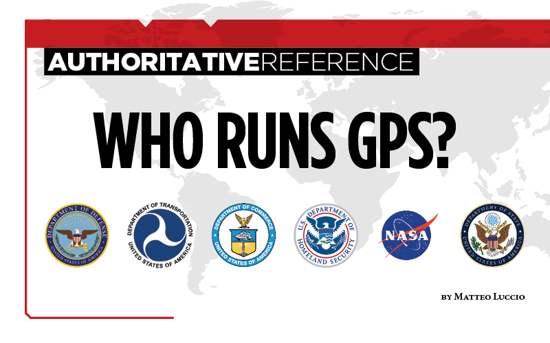
Nearly 50 years ago, in December 1973, the Defense Systems Acquisition Review Council approved the Navstar Global Positioning System for entry into Phase I of development. Since then, through its development, deployment and continuing modernization, GPS has grown into a complex program. It is operated by the Department of Defense based on legislation from Congress, executive orders from the White House, and policies established jointly with the Department of Transportation. It supports U.S. military missions as well as myriad scientific, commercial and consumer applications around the planet. Of course, the last category, with its billions of users, now dwarfs all the other ones combined.
The GPS program, with an annual budget of nearly $2 billion and no user fees, is a gift from U.S. taxpayers to the world. It has staff in Washington, D.C.; at the Pentagon in Arlington, Virginia; at Schriever Space Force Base, Colorado; at the Space Systems Command at Los Angeles Air Force Base, California; at Cape Canaveral, Florida; at the U.S. Coast Guard Navigation Center in Alexandria, Virginia; and at GPS ground antennas in additional locations around the world. From the White House to Congress to aerospace companies, from military officers to civilian civil servants, from policy makers to engineers, from the East Coast to the West Coast to remote islands in the Pacific, Indian and Atlantic Oceans, GPS is a vast enterprise — most of which is little known even to people in the industry and virtually unknown to the public.
The Global Positioning System is a vast and mostly unknown enterprise. This section — the first in an occasional series of authoritative reference pieces in this magazine — aims to clarify who does what to maintain GPS as a fantastic global utility. The relevant missions of agencies or units are in italics.
After I researched and drafted the piece, I asked the experts listed below to review it and provide corrections and additions. While grateful for their substantial feedback, I take sole responsibility for any remaining errors or omissions.
Thank you to the following experts:
Harold W. Martin III, Director, Space-Based Positioning, Navigation & Timing, National Coordination Office
Michael J. Dunn, Capability Area Integrator for PNT, Space Systems Command, United States Space Force
Lt. Col. Robert O. Wray, Commander, 2nd Space Operations Squadron, United States Space Force
Scott R. Calhoun, Commanding Officer, Navigation Center, United States Coast Guard
Paul Benshoof, Technical Director, 746th Test Squadron (AFMC), Central Inertial and GPS Test Facility
Bernard Gruber, Senior Director, Northrop Grumman
Please return to this page periodically to read corrections and updates to this special section. If you spot any significant inaccuracies or omissions, please bring them to my attention by writing to me at [email protected].
The Space Foundation has decided to reschedule the 36th Space Symposium for Oct. 31 to Nov. 2. It will still take place at The Broadmoor in Colorado Springs.
According to the Space Foundation, the 36th Space Symposium will gather leaders, innovators and entrepreneurs from the civil, commercial, military, research and international sectors to share, explore and partner on efforts that will impact our lives beyond Earth and upon it.
“Working with our partners, The Broadmoor, the City of Colorado Springs, our corporate members and other key stakeholders, we look forward to welcoming everyone back to Colorado Springs to celebrate one of the world’s most inventive and impactful communities,” said Rear Admiral Tom Zelibor, CEO of the Space Foundation. “We will continue to monitor all of the public health reports and adhere to all of the federal, state and local orders regarding public assemblies but we have confidence in planning ahead for a future that brings our community safely back together in Colorado Springs.”
As a result of the date and timing changes for this year’s symposium, attendees will find a revamped agenda from what was originally scheduled for this spring, the Space Foundation said. Scheduled changes can be found here.
In addition, registration fees paid to attend the 36th Space Symposium will be automatically transferred to the rescheduled program. Those choosing to not attend the rescheduled Symposium are requested to notify [email protected] to receive a full refund of registration fees paid.
Registration has opened for the 35th Space Symposium, sponsored by the Space Foundation and taking place April 8-11 in Colorado Springs, Colorado. The Space Symposium provides a forum to discuss, address and plan for future achievements in space.
According to show organizers, the event represents all sectors of the space community from multiple spacefaring nations, including space agencies; commercial space businesses and associated subcontractors; military, national security and intelligence organizations; cyber security organizations; federal and state government agencies and organizations; research and development facilities; think tanks; educational institutions; space entrepreneurs and private space travel providers; businesses engaged in adapting, manufacturing or selling space technologies for commercial use; and media that inspire and educate the general public about space.
The event will feature a number of speakers from NASA, Raytheon, the U.S. Air Force, the Canadian Space Agency, the Mexican Space Agency, the Korean Aerospace Research Institute and more.
Attendees can also choose from a number of sessions, as well as purchase tickets for a variety of networking opportunities, including the Corporate Partnership Dinner, General James E. Hill Lifetime Space Achievement Award Luncheon, Women’s Global Gathering Luncheon and Space Technology Hall of Fame Luncheon.
The global space economy grew to $314.17 billion in commercial revenue and government budgets in 2013, reflecting growth of 4 percent from the 2012 total of $302.22 billion, according to The Space Report 2014. The report was issued this week by the Space Foundation during the 30th Space Symposium being held this week in Colorado Springs, Colorado. GPS World Defense Editor Don Jewell is providing coverage from the symposium.
Commercial activity — space products and services and commercial infrastructure — drove much of the increase. From 2008 through 2013, the total has grown by 27 percent. Commercial space products and services revenue increased 7 percent since 2012, and commercial infrastructure and support industries increased by 4.6 percent.
Government spending decreased by 1.7 percent in 2013, although changes varied significantly from country to country. Substantial space budget cuts in the United States outweighed gains in Canada, India, Russia, South Korea, and the United Kingdom, all of which increased budgets by 25 percent or more.
These new global space economic numbers come from the Space Foundation’s publication, The Space Report 2014:The Authoritative Guide to Global Space Activity, which was released today. Data was compiled from original research and a wide variety of public and private sources, and analyzed by Space Foundation researchers.
Key Findings
The 160-page book contains worldwide space facts and figures and is illustrated with photographs, charts and graphs. Within are myriad examples of the benefits of space exploration and utilization, the challenges facing the space sector, the opportunities for future growth and the major factors that shape the industry. In addition, The Space Report includes an overview of each sector, definitions, and up-to-date information on space infrastructure, facilities, launches and programs.
Following are just some of the many interesting facts and analyses found in The Space Report 2014: The Authoritative Guide to Global Space Activity:
Launches and Satellites
81 launch attempts took place in 2013, an increase of 4 percent from the 78 launches in 2012 (and above the five-year average of 79 launches per year).
The majority of these launches were conducted by Russia (32 launches), the United States (19), China (15), and Europe (7).
After two years of conducting fewer launches than China, the United States rose again to second place, partly due to an increased operational tempo as U.S. commercial providers launched cargo resupply missions to the International Space Station.
New launch vehicles made their first flights (or first successful flights) in five countries–the Antares and Minotaur V in the United States, Soyuz 2.1v in Russia, Kuaizhou in China, Epsilon in Japan, and KSLV-1 (also called Naro-1) in Korea.
The number of satellites launched during 2013 increased by nearly two-thirds compared to 2012. This was largely due to a significant uptick in the number of satellites with masses below 91 kilograms (200 pounds). These microsatellites constituted more than half of the 197 satellites launched in 2013.
Many of the microsatellites were short-lived technology demonstrations, but there is a considerable degree of interest in future possibilities for constellations of small satellites that provide valuable services on an ongoing basis.
Workforce
According to U.S. Bureau of Labor Statistics (BLS) data, the size of the U.S. space workforce declined for the sixth year in a row, dropping 3.5 percent, from 242,724 in 2011 to 234,173 in 2012 (the most recent full year for which data is available) – a decrease of about 8,500 workers. However, the changes varied by sector, with some portions of the space industry growing while others contracted.
The United States’ National Aeronautics and Space Administration (NASA)’s civil servant workforce remained essentially flat, declining by less than 1 percent to reach 18,068 in FY 2014. Although the workforce continues to become more concentrated at higher ages, NASA has experienced moderate success in recruiting and retaining young workers below the age of 35 during the past five years.
Both Europe and Japan saw increases in space workforces; the European industry workforce grew by 1.5 percent in 2012, adding approximately 500 employees; in Japan, the overall workforce grew by 11 percent, while employment at the Japan Aerospace Exploration Agency (JAXA), Japan’s government space agency, dropped.
The Space Foundation Index
As of December 2013, the Space Foundation Index was 94.22 percent above its value at inception in June 2005. The Space Foundation Infrastructure Index outperformed the S&P 500 and the NASDAQ during 2013, while the main Space Foundation Index and Space Foundation Services Index did not perform as well as the NASDAQ, but substantially better than the S&P 500. These indexes, which are updated daily on the Space Foundation website, are easy-to-understand mechanisms for gauging the financial performance of space industry companies listed on U.S. stock exchanges.
The Space Report is published annually by the Space Foundation, which works with a leading aerospace consulting firm, Futron Corporation, to research and analyze government and industry trends in space activity. The stock market analysis is provided by ISDR Consulting, LLC, a management consulting firm specializing in the space, satellite and technology sectors.
Colorado Governor John Hickenlooper signs a space-friendly bill at the 30th Space Symposium in Colorado Springs.
Colorado Ranks Third in Space-Friendly States
Governor John Hickenlooper (D) of Colorado made the trek from the statehouse in Denver yesterday to sign key space-friendly Colorado legislation at the 30th Space Symposium in Colorado Springs. The world’s largest annual space symposium takes place at the famed Broadmoor Resort in Colorado Springs and nominally draws a crowd of space aficionados and professionals, government and civilian alike, approximately 9,000 strong. Colorado House Bill #1178 is titled the “Sales And Use Tax Exemption for Qualified Property Used in Space Flight,” and it is hoped this legislation will help expand aerospace industry growth in Colorado. Spokesmen from the governor’s office and Tom Clark from the Colorado Space Coalition stressed that Colorado currently has the nation’s third-largest aerospace economy, and the new tax-exemption bill is part of Colorado’s strategic initiatives to support and grow one of its strongest industries. Indeed, Colorado Springs is known in government circles as the Home of Military Space. Several key space industry experts (both government and civil) present at the bill signing stated that the new tax exemption will add an important boost to keep Colorado ahead of the competition and further stimulate the state’s massive aerospace economy. Colorado is known as a national hub for geospatial technologies, remote sensing and satellite-based services. The space services and technology providers comprise the largest category of the state’s space economic activity, bringing in $6.3 billion in annual revenue. Currently, the Colorado space-based revenue is growing at a steady 8 percent annual rate. In conversation with Tom Clark, he admitted that in years past, Colorado has actually occupied the number-two raking for a state’s space-based economy, but was recently surpassed by Florida, which has similar tax-friendly legislation on the books. Clark was confident that with the new legislation Colorado would, like Avis, soon be number two again.
Colorado Gov. John Hickenlooper discusses space matters at the 30th Annual Space Symposium with Braxton Chairman of the Board Kevin O’Neil and Braxton CEO Frank Backes.
Tuesday, the 26th of June, started off as a beautiful day in Colorado Springs, if you ignored the towering plume of smoke to the west from the Waldo Canyon Wildfire.
The wildfire started three days before in the popular Waldo Canyon hiking area in the Rocky Mountains just off Highway 24. While people in the Colorado Springs area were concerned, there were currently eight other wildfires raging in the state of Colorado and over the past month arsonist(s) were suspected of starting up to 20+ wildfires. So, many had become inured to the sight and smell of smoke. Only one serious wildfire was known to be currently out of control in Colorado at the time, so concerns in the Colorado Springs community could be described as moderate.
Then, at 1630, that’s 4:30 P.M. for my non-military readers, the wildfire displayed its true personality. Driven by what meteorologist later described as “a perfect storm of weather conditions” and howling winds exceeding 65 miles per hour out of the West, the fire spread eastward toward Colorado Springs at an alarming rate.
The dark black roiling smoke blotted out the sun, which was suddenly no more than an angry red disc in the sky providing little illumination. The suddenly disobedient wildfire began marching, indeed running and leaping, relentlessly eastward voraciously consuming homes and lifetimes of memories. My wonderful wife of 32 years and I had all of five minutes to leave our comfortable foothills home, amid swirling, stinging, cloying black smoke, flying embers, and flames that danced over 100 feet high. It was simply a terrifying event. As we fled the wildfire with quickly gathered pictures, important papers, and little more than the clothes on our backs, neither of us thought we would ever see our home of 22 years or anything inside intact again.
Fox 21 file photo of the Waldo Canyon Fire in Colorado Springs, June 26, 2012.
Evacuation
The wildfire and smoke turned a now-indelible drive down familiar streets into an alien landscape. Visibility was limited to less than ten feet and premature night had fallen in a fiery, smoky, unbreathable pall on more than half of Colorado Springs. In the end more than 32,000 people were evacuated, 11,000 homes were threatened in several nearby communities, and approximately 350 homes were lost in the Mountain Shadows neighborhood in the foothills of the Rocky Mountains. Firemen tell me the heat was incredibly intense, and homes that were lost were quickly turned into nothing more than smoky white ash. It was a truly devastating turn of events but without all the capabilities generated by and enabled by GPS, the results could have been much worse. Mayhem was avoided, and I have no doubt that GPS units of various descriptions guided thousands of people to safety that unforgettable day. Thousands of people, who suddenly and unexpectedly found themselves to be evacuees, followed voice and visual commands from small electronic GPS units that eventually led them to safety and safe havens all around the state of Colorado.
Heroes
Firefighters and support agencies from around the U.S. responded. When the fire broke out and wreaked havoc in the Rocky Mountain foothills, there were ~423 firemen fighting the fire. After the breakout and at the height of the fire, there were firefighting assets from every source available including the DoD and the National Guard. They totaled more than 1500 in number, and in my book they are all heroes. Case in point, as we were fleeing down the mountain from our home in a billowing preternatural darkness, along with thousands of others just like us that just wanted to get out safely, the brave men and women of Fire Station #12, at the end of our street, were racing up the mountain to confront the fire and save our homes and our neighborhood. In this regard I hold them and all firefighters in the same regard as U.S. Marines, who when shots are fired run toward the sound of gunfire, not away from it. Our courageous local firefighters, joined by a thousand more from across our nation, were running toward the fire, not away from it. Their bravery brought tears to your eyes that had nothing to do with the smoky atmosphere.
We Survived
All this occurred less than two weeks ago — as I write this column from my home, which was fortunately spared, albeit with a slightly smoky bouquet. We certainly consider ourselves to be blessed as the fire was stopped just a few hundred feet from our neighborhood.
When we finally and gratefully returned home and were able to fire up our computers, I discovered several testimonials from readers, first responders, firemen, and GPS users extolling the virtues first of the firemen and then of the GPS equipment that played such an important role in averting a total catastrophe.
One note from a couple who had only been in the local area for a couple of months described their experience fleeing before the raging wildfire in an only vaguely familiar neighborhood suddenly plunged into darkness, with air that was difficult to breathe and street signs that were unreadable. However, they movingly wrote, “Our brand new Garmin, that led us across country, also led us to safety during the WC wildfire and it was extremely comforting to know that the GPS knew the way…it eventually led us safely to a hotel outside the evacuation area…we had no idea which way to go and were totally dependent on our Garmin…we had a map but in all the confusion and panic it was of very little use…we could not read the map in the sudden darkness…we just listened to that small little voice that said…prepare to turn right in 400 feet…it saved our lives.”
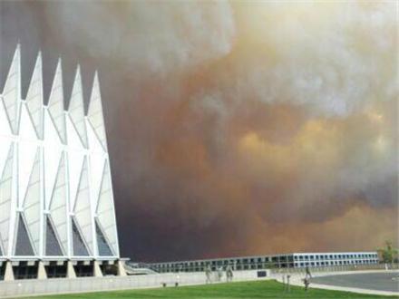
USAFA under Attack by the Waldo Canyon Wildfire.
Another shining example of bravery in firefighting came from the various agencies and firefighters that joined the firefighters from the United States Air Force Academy (USAFA). A USAF Colonel went on local television and declared that they had evacuated the academy and then established what they hoped was an impenetrable several-mile-long firebreak with bulldozers and heavy equipment, and although their numbers were limited, they would not allow the fire to penetrate the USAFA beyond that line and hold the line they did. These brave men and women were not all trained and certified wildfire firefighters, but they had the courage of their convictions and they held the line. The fire did not penetrate the USAFA beyond that firebreak. There are many more examples of true heroism that are too numerous to mention.
Firefighters from across the Nation
I spoke with many first responders — as I said, eventually 1500+ were fighting the fire — from as far away as California and Utah, who knew nothing about Colorado Springs or the Rocky Mountains to the west when they arrived on the scene, but who efficiently navigated the fiery wasteland with their map reading skills and various official and commercial/civil GPS units, both stand-alone and embedded units. And again Garmin units were almost always mentioned in the conversation — from sophisticated Garmins using elaborate forestry and military grid systems used by military and Forest Service first responders, in vehicles and aircraft, to wrist Garmins that simply allowed users to immediately locate their positions on a local area map.
At the height of the WC Wildfire, which as I write this is 98% contained but most certainly not under control, there were firefighters and first responders from the Forest Service, U.S. Army, U.S. Air Force, National Guard (Army and Air Force), the U.S. Air Force Academy, and numerous federal agencies to include C-130 MAFF (Modular Airborne Fire Fighting System) units from Peterson AFB, in Colorado Springs (the 302nd) and from a National Guard Unit in Wyoming. The majority of the firefighters were not from the local area; consequently, most all of them were using an incredible array of various GPS devices to locate and navigate. And in most all cases there was some reference to an external map. Local television stations, which covered the fire exclusively for the first five days, all had different and multiple maps and many were frankly almost indecipherable. What was interesting is that in almost every case there was a definite and clearly visible unfamiliarity by the participants with both the maps and even the local area. It seems that except for certain branches of the military and those who use maps daily in their profession, map reading and orienting skills have fallen by the way side, if indeed there was ever any initial proficiency. It is a skill we all need to relearn.
Maps and GPS
A very close friend and business colleague of mine, Robert Rosenberg (Maj Gen USAF Retired), once ran what was then known as DMA or the Defense Mapping Agency and is now known as NGA or the National GeoSpatial Intelligence Agency. NGA specializes in maps and may be the best in the world at gathering the necessary data and producing them. Indeed, some of the NGA maps are simply amazing and true works of art. However, the sad fact is they are utterly useless if you don’t know how read and utilize them properly.
Historically, some of the inaccuracies wrongly attributed to the GPS were actually map errors. I personally observed an incident where Dr. Ivan Getting, a possible father of the GPS, whom I have written about previously, determined the exact geographical coordinates of his home from a long integrated GPS position, but which DMA maps showed to be in the middle of a lake. Obviously the map was several hundred meters in error, and this was a common occurrence in the “old” days. However, modern map-making techniques and accuracies today are such that this is no longer the case. But even the best and most accurate map in the world today is useless if we don’t know how to make use of it — we must learn to orient ourselves, accurately locate our position on a map, and generally make use of the features all modern maps provide. It is time to stop blaming the maps and map makers and start learning to use the phenomenal maps and PNT tools at our disposal.
Now, please don’t misinterpret my comments or take them out of context. After all, this is GPS World magazine and there is not a greater proponent of GPS anywhere than yours truly; however, I have also always been a proponent of developing simple map reading skills as well, which to some seems to be anything but simple.
Dwindling Skillsets
Like many of you, I have read passionate and somewhat inaccurate articles bemoaning the use of GPS for the navigation and situational skills that are lost by blindly following GPS dictates, and certainly I have received numerous letters from and responded to those who prefer to navigate using granddad’s old Texaco map in the glove compartment. However, unlike many uninformed critics of the GPS and proponents of map reading skills, I do not believe the two are mutually exclusive. In fact, one of the features I most appreciate about the GPS navigation system in my Audi is the traffic avoidance feature that when potential routes are blocked, or conflicts arise, automatically reroutes, without ever broadcasting that most irritating word “recalculating.” The other feature is the map display zooms out and displays more map features and alternate routes, so if I wish I may manually choose an alternate route. I have, just as you do, the option of blindly trusting the GPS, picking my own route on the map display or, as I most frequently do, using a combination of both map-reading skills and PNT automation.
In the grand scheme of things, map-reading skills are not difficult to develop and the basics are simple; however, it does take some practice — practice that can be gained every day by choosing different routes to work or common destinations and challenging yourself and your map reading skills when you travel. And here is a novel idea — actually read the instructional/operators manual that came with your GPS — learn all its secrets and built-in capabilities. You might be surprised by what you will learn and the skills GPS can help you develop.
Plethora of PNT Equipment
I had the enviable opportunity to speak with representatives from many of the more than 20 agencies that responded to the Waldo Canyon Wildfire and get a brief look at some of their PNT equipment. The equipment in general ranges from high end and highly sophisticated official first responder units with built-in communications capabilities to Garmins, iPhones, and iPads. The Garmins were equally split between vehicle-mounted, aircraft-mounted, and portable units, while the more sophisticated units were large and considered more appropriately as portable units with communication capabilities than as true handhelds. By far the most noticeable and prevalent units, other than Garmins, were Apple iPads, especially the new iPad IIIs with retina displays and ruggedized with Otterbox and Otterbox-like enclosures. There are numerous mapping and GPS/GIS applications that run on the iPad and other portable display devices, and in the future I will be reviewing the best mapping applications to assist you in choosing the one that is best for your situation. However, regardless of the application or device it would behoove us all to learn a bit more about maps and the devices we have on hand to display them, to include becoming familiar with that old Texaco map in the glove compartment, even if it is a last resort.
Tragically two souls perished in the Waldo Canyon Wildfire, as they were unable to evacuate their home before the fast moving wildfire overcame them. The Waldo Canyon Wildfire is truly a catastrophic event that will long be remembered in Colorado, and from which we can all learn a valuable lesson. And I wholeheartedly believe that many lives were and will continue to be saved by GPS/PNT devices in these types of catastrophes. We simply owe it to ourselves and our loved ones to learn how to best use our GPS/PNT equipment now, so it will be second nature when a catastrophe occurs. Take it from me, you life may depend on it. When you are fleeing for your life, you need all the help and good fortune available — it is not the time to figure our how your GPS/PNT device really functions.
God bless our firefighters and first responders.
Until next time, as Tennessee Ernie Ford said, “God willin’ and the creek don’t rise,” happy navigating and remember to read your GPS/PNT equipment owners manual.