Autopilot platform developer UAV Navigation is integrating Iris Automation’s detect-and-avoid Casia software into its advanced autopilot solution, Vector. UAVs equipped with Vector and Casia now can detect uncooperative crewed aircraft in their airspace and autonomously or manually take corrective action, avoiding potential collisions.
The integration comes as Iris Automation releases Casia Software v2.2. The release also includes improvements to performance, track fusion and flight data uploads. Casia Software is embedded in all Casia systems and uses computer vision and artificial intelligence to detect and classify aircraft intruders, similar to human pilots.
Vector autopilots are specifically designed to execute flight completely autonomously, even if the remote-control datalink becomes unavailable or fails. They are used by a wide range of commercial clients flying rotary wing, target drone, fixed wing, and VTOL uncrewed aerial vehicles, worldwide.
UAV Navigation specializes in the design of guidance, navigation and control solutions for unmanned aerial vehicles (UAVs). Iris Automation is a safety avionics technology company pioneering detect-and-avoid (DAA) systems and aviation policy services that enable customers to build scalable operations for commercial drones.
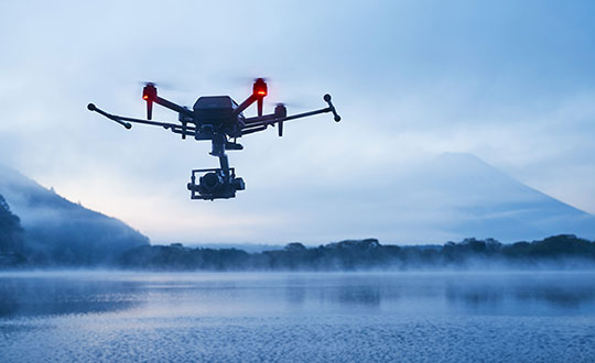
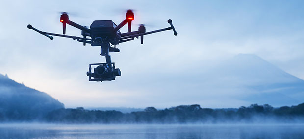
Sony’s first professional drone is small, but can be equipped with alpha mirrorless camera
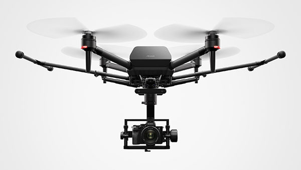
Sony Electronics Inc. has announced its first professional drone, the Airpeak S1. An introductory model in the new Airpeak line, the S1 is a small drone that can be equipped with Sony’s full-size mirrorless interchangeable-lens Alpha camera.
The new drone uses a proprietary motor, propeller, control system and sensing technology, allowing it to fly at extremely high speeds with stable wind resistance.
The Airpeak S1 features an advanced remote controller that can support the production of high-quality aerial images and freely control the aircraft. It also includes obstacle detection, automatic flight control via sensing and increased safety via cloud management of the aircraft and flight information.
“Sony is excited to launch our new drone business with the Airpeak S1,” said Yang Cheng, Vice President, Imaging Solutions, Sony Electronics Inc. “Combining an extremely compact size with some of Sony’s most advanced imaging, sensing, AI and robotics technologies, the S1 will allow content creators, storytellers and commercial professionals to capture that which they’ve never been able to capture before.”
Advanced flight performance
The new Airpeak S1 offers dynamic flying capabilities, including a maximum speed of 55mph (90km/h), a maximum angular velocity of 180°/s, and a maximum tilt angle of 55°.
Propulsion technology using a combination of key devices developed by Sony provides wind resistance in strong wind speeds up to 44.7 mph (20 m/s).
In addition to the lightweight, highly efficient, sturdy and responsive proprietary 17″ propeller and brushless motor, the Airpeak S1 is equipped with an electric speed controller (ESC) for optimal control of these components. A unique, high-performance flight control system integrates the propulsion device and all sensor information to ensure stable flight and high maneuverability, Sony stated.
Stable flight by sensing
Stereo cameras equipped with Sony’s image sensors are installed in five locations (front, back, left, right, bottom) of the aircraft. Sony’s vision-sensing processor, which processes camera data at high speed and with low power consumption, and proprietary algorithms are used to accurately estimate the aircraft’s spatial position and orientation in real time, enabling stable flight even in environments where it may be hindered, such as indoors or under bridges.
The Airpeak S1 is also equipped with a unique high-performance flight-control system that integrates all sensor information such as inertial measurement unit (IMU), direction, barometric pressure and infrared ranging to optimize the propulsion device.
The Airpeak S1 uses multi-directional sensors to enable its obstacle braking function. The front, rear, left and right stereo cameras and the infrared range-finding sensor mounted on the top recognize obstacles in the vicinity of the aircraft, allowing the aircraft to automatically decelerate and stop according to its behavior and the surrounding conditions.
Photo: Sony
Camera and lens variations
Users have the flexibility to choose the right Alpha system for their desired application to expand their filmmaking horizons. The Airpeak S1 is compatible with a wide range of camera bodies including:
Alpha 7S series and FX3 for high descriptive capability with suppressed noise
Alpha 7R series for ultra-high definition
Alpha 9 series and others for distortion-free images
The Alpha 1, which can shoot footage in 8K, is also compatible.
The drone includes Airpeak Flight, an iOS- and iPadOS-compatible application that integrates the aircraft, transmitter, camera and gimbal, allowing the operator to monitor status information such as flight distance and remaining battery power, and change various operations and settings on the screen.
Airpeak S1 also includes a dual-operation mode so that one user can operate the drone while another user can operate the gimbal and camera simultaneously while checking the same image, even in complicated scenes. The first-person view camera, which can be tilt-operated from the remote controller, is mounted on the nose of the aircraft and is useful for the operator to check the direction of the aircraft and the direction of travel.
Photo: Sony
Airspeak Base
The new drone includes “Airpeak Base,” a web application that allows the operator to manage equipment, create flight plans, and manage flight logs. In the equipment management, information on the equipment used is automatically listed and managed based on the flight log. This allows the operator to check the condition of the aircraft before going to the field, minimizing on-set issues.
With Airpeak Base, the operator can create advanced flight plans and automatically fly the aircraft along the same course repeatedly, as if the drone were on rails installed in the air. It is able to set the position (latitude, longitude and altitude) and speed of the aircraft along the timeline, and specify the orientation of the gimbal and the timing of video or still image shooting. It can also draw smooth curves on the map. Reproduction flight is an automatic flight function that reproduces the flight route, gimbal, and camera movements based on the flight logs that have been flown in the past.
All aircraft information, including logs, can be uploaded to the cloud via the mobile app Airpeak Flight. Airpeak Base allows users to check the status of the aircraft and can provide notifications if necessary. Users can manage the status of all managed aircraft in one place before flight. Past flight logs can be viewed on the logbook screen, and details such as in-flight errors can also be reviewed.
Sony Group will be exhibiting Airpeak S1 at Japan Drone 2021, a drone exhibition to be held at Makuhari Messe in Chiba, Japan, June 14-16. In addition, Izumi Kawanishi, Senior Vice President, AI Robotics Business, Sony Group Corp. will provide the keynote speech on the morning of June 14.
In many ways, 2020 would be another big year for commercial drones. The market has witnessed slow and steady growth over the years, and according to Allied Market Research, the global commercial drone market is expected to reach $10.73 million by 2022, growing at a CAGR of 26.2% from 2016 to 2022. This exponential growth is due to the high demand for cost-effective, energy-saving and eco-friendly OLED lighting coupled with growth in display and large screen backlit market. On the other hand, the outbreak of COVID-19 has reshaped every other industry and business function in the world and the commercial drone industry is no exception.
Use of commercial drones during COVID-19 pandemic
Even though complete ramifications of COVID-19 are not clear, some impacts of the standstill of the global economy beginning to be felt. Needless to say, the drastic changes in the drone industry are imminent and the market players would feel them over the coming years.
Search & rescue mission
Initially, several countries used commercial drones for search and rescue missions. Moreover, some countries used them spanning deserts and high population areas. As drones have the potential to visualize and communicate with complicated areas, the demand for them increased to supervise the dense and urban areas during the initial stages of the COVID-19 outbreak when panic was taking its root. Thanks to drone technology, officers could easily scan an area and broadcast necessary instruction if the area is infected while maintaining the safety of the officials.
Delivery of essentials
Since the declaration of a pandemic, the local governments have asked citizens to maintain a safe distance and limit the exposure to the virus. This greatly affected the food and package delivery systems, as it may be a potential factor of contamination. Although drone package deliveries are not used across the globe, few tests in the U.S. and the Dominican Republic have proven to effective. The use of commercial drones is encouraging as most of the commercial drones can be modified with payload drop mechanism and used for package deliveries without risking both parties. The package delivery system by drones is particularly important in areas where the presence of the virus is imminent such as hospitals that actively treat the virus.
Disinfection of public areas
The use of commercial drones is effective in disinfecting area. Even though more information about the virus is being discovered, the officials have declared that it can survive on hard surfaces such as chairs and buses. Thus, public places pose a huge risk of infection. To prevent further spread and disinfect public areas, some countries have deployed agriculture spraying drones filled with disinfectant instead of pesticides.
Apart from this, the entire country of China has implemented commercial drones to perform simple temperature check processes before admitting visitors into the building. As the major symptom of the virus is fever, the use of commercial drones to spot potential patients without compromising the safety of anyone.
Major trends in the commercial drone industry
The increase in counter-drone solutions has almost doubled in the past year and its market is expected to grow rapidly in 2020. Urban air mobility has been a buzzword since the rise of the commercial drone market. In addition, drone deliveries have already started in the U.S., Ghana and Australia. Developing countries such as China and India have actively used drones for drugs and food delivery. In the future, the development of passenger drones will demand more funding to get certified, boosting the passenger drone market.
The increased popularity of drones would press the government to review regulations regarding unmanned vehicles. In the next five years, commercial drones would enter in unmanned traffic management and remote identification.
In the coming years, the adoption of aerial drones and commercial drones are likely to enter various market apart from healthcare, agriculture, and entertainment. Instead, it will grow in industries such as insurance, public safety and first responders, and mining.
Apart from this, the advancements in imaging sensors and aerial imaging software are expected to improve artificial capabilities. Currently, the majority of the technologies applied in commercial drones include cloud-based machine learning and AI-based drones are still in the development stage. The increased adoption of drones and advancements in sensor technology and automation will open new opportunities in the coming years.
Thanks to the early hype about commercial drones and how they hold the potential to transform industries, there will be a huge investment in the market to make such forecasts in reality. Due to the COVID-19 pandemic, the adoption of commercial drones has increased. Over the last few years, there was public distrust in the technology. However, the benefits of use of drones during pandemic have reduced some concerns about commercial drones. In addition, new governmental regulations regarding the use of unmanned vehicles clear the misunderstandings and concerns about drones with safety and privacy. However, one thing is sure, despite the tragic start of the new decade, the COVID-19 pandemic has been favorable for the commercial drone market and is expected to bring opportunities in the future.
Swamini Kulkarni holds a medical bachelor’s degree from Pune University, and works as a content writer exploring the impact of technology on human life.
Streamlined application and 30-minute response improve unlocking process.
DJI’s Matrice 200 drone. (Photo: DJI)
Drone maker DJI is introducing improvements to its geofencing system. Professional drone pilots with authorization to fly in sensitive locations can now use a streamlined application process to receive unlocking codes within 30 minutes.
DJI’s geofencing system uses GPS and other navigational satellite signals to automatically help prevent drones from flying near sensitive locations such as airports, nuclear power plants and prisons. These improvements are carefully designed to help expand the beneficial uses of drones in sensitive areas that have been restricted in DJI’s geofencing system.
While those areas will remain restricted to more casual drone pilots, DJI now staffs its global authorization team around the clock in order to process applications and provide unlocking codes quickly.
Professional drone pilots can apply to unlock restricted zones at www.dji.com/flysafe/custom-unlock. This portal page allows pilots to easily enter information about their aircraft and controller, as well as authorization documents supplied by the controlling authorities in areas where they wish to fly.
Enterprise users can for the first time include multiple aircraft in a single unlocking request.
“DJI now processes most requests within 30 minutes, though requests involving unusual circumstances or requiring additional documentation may need additional time,” said Michael Perry, managing director of North America at DJI. “By making it easier for authorized pilots to put drones to work in sensitive areas, DJI is once again showing why professional drone operators choose our aerial platforms for the most important tasks.”
“DJI first implemented geofencing in 2013, and it is now established as an important tool to help our customers make thoughtful flight decisions, while also addressing legitimate concerns about safety and security by helping prevent unauthorized flights in the most sensitive locations,” said Brendan Schulman, vice president of policy & legal affairs at DJI. “These improvements illustrate DJI’s ongoing commitment as the industry leader to continually improving the safety features we implemented years ago, while enabling beneficial applications for our technology.”
For more information about how enterprises are using DJI products to work safer, faster and more efficiently, visit enterprise.dji.com.
Measure, a United States’ commercial operator of drones, and DJI, manufacturer of unmanned aerial vehicles, are partnering to pair advanced UAV technology with operational excellence so commercial enterprise customers can achieve their most demanding business goals.
“Our partnership with DJI allows Measure to enhance technical capability and scale business operations across all verticals,” said Measure CEO Brandon Torres Declet. “This alliance will allow our companies and franchisees to be the vanguard of innovation for commercial UAV operations, using DJI’s proven technology and our experienced pilots.”
“Businesses increasingly recognize that having a knowledgeable and experienced operator at the controls is key to using UAV technology most effectively,” said Jan Gasparic, Strategic Partnerships and Business Development, DJI.
“Measure’s application-specific pilot training and deep knowledge of flight regulation allows them to set the standard for commercial UAV operations in the field,” Gasparic said. “We are looking forward to expanding our successful relationship with Measure, allowing more businesses to perform critical functions faster, safer, more efficiently and at a lower cost.”
Alongside the service collaboration, Measure and DJI will assist organizations to develop and deploy UAV operations in the fields of agriculture, energy and media. Organizations will now have a comprehensive partner to explore demanding operations such as spraying with DJI’s Agras MG-1 agricultural drone, or broadcasting live directly from a UAV to a newsroom. This partnership demonstrates Measure and DJI’s commitment to fostering a vibrant commercial ecosystem to accelerate the economic growth and innovation of the drone industry.
Esri and Harris Corporation are embarking on a broad strategic relationship to develop modernized foundation GEOINT data production, apps and tools within a WebGIS environment, for federal agencies.
The partnership will advance the state-of-the-art in automated GEOINT (geointelligence) production methods leveraging commercial-off-the-shelf (COTS)-based solutions.
The collaborative effort will help programs across multiple security domains to meet the expected surge of commercial imagery from small satellites, unmanned aerial system (UAS) platforms and open-data sources.
Visit Esri and Harris Corporation at GEOINT Symposium 2016 this week: booth 828 Harris; Booth 600 Esri.
According to a new TechSci Research report, the commercial drone market is projected to grow at a CAGR of 27 percent until 2021, with North America anticipated to continue its dominance as the largest commercial drone market through 2021.
According to the report, the rotary-blade drone segment dominated the global commercial drone market in 2015 because of its various technical features and benefits that enable these drones to perform intensely in photography, mapping, oil and gas sector and mining industry.
Moreover, continuing growth of the global mining market, which was valued at around $1.5 trillion in 2015 and is projected to grow at a CAGR of more than 7 percent during 2016-2021, is expected to further boost the prospects of commercial use of drones in the mining sector over the next five years. Rotary blade drones are designed to fly in all directions as well as hover at a fixed position.
In 2015, these drone types accounted for a market share of more than 75 percent in the global commercial drone market because of their versatility and increasing application areas.
Fixed-wing drones are the other major drone type, and these drones are being widely used in precision agriculture and aerial mapping. Precision farming utilizes several technological advancements such as geo location tracking, data management, and crop health analysis in order to ensure better productivity as compared to conventional farming methodology.
Higher profitability and productivity, coupled with expanding global demand for crop yield are few of the factors poised to drive the global precision agriculture market at a CAGR of over 11 percent during 2016-2021, thereby propelling demand for drones used in the precision agriculture industry.
Insitu and BNSF officials launch ScanEagle in support of the FAA’s pathfinder initiative (Photo: Insitu)
Insitu and PrecisionHawk have formed a strategic alliance to provide UAS solutions that help commercial enterprises achieve safe unmanned flight for extended and beyond-visual-line-of-sight operations. Insitu is a provider of information and unmanned aircraft systems (UAS) for commercial, civil and military operations, and PrecisionHawk is an aerial data provider.
Both companies are exhibiting at this week’s AUVSI Xponential 2016 show in New Orleans.
The alliance also leverages the extensive research and testing capabilities of two of the participants of the Federal Aviation Administration (FAA) Pathfinder Program, which is dedicated to expanding the use of UAS within the nation’s airspace.
“While our businesses are diverse, the areas where we intersect have tremendous potential for creating new opportunities in the commercial industries we both serve,” said Ryan M. Hartman, Insitu President and CEO. “This alliance ensures that more businesses will explore what unmanned technology can offer.”
Thanks to the integration of each company’s proprietary platforms, hardware and software, Insitu and PrecisionHawk plan to deliver even more data insights.
“Our customers are always pushing us to bring more advanced and comprehensive solutions, and we go above and beyond to make sure we are developing tools that serve their specific needs,” said PrecisionHawk president Christopher Dean. “We believe this alliance with Insitu will help us deliver on our promise even more.”
The emphasis of the U.S.-based alliance is on providing business intelligence support for commercial operations, including asset protection, property preservation, safety enhancement and environmental monitoring.
According to a new report from Tractica, by the end of the next decade, annual revenue from drone-enabled services will be more than double the revenue from sales of commercial drone hardware units themselves.
The market intelligence firm forecasts that global commercial unmanned aerial vehicles (UAVs) services revenue will grow from $170 million in 2015 to $8.7 billion by 2025.
UAVs are gaining significant traction in a variety of industries, including oil and gas, insurance, public safety, film and media, and agriculture. While the number of drones being shipped for commercial markets is often the most visible trend, the largest revenue opportunity in the sector lies in the various services that these drones will enable.
The largest service applications will be mapping, aerial assessment and prospecting, but smaller opportunities for drone services will also include disaster relief, early warning systems, data collection and analytics, environmental monitoring, package delivery, and filming and entertainment.
“Commercial drone operators around the world are quickly realizing the potential for UAVs to be harnessed for a variety of services in a more efficient manner than can be achieved using conventional means such as satellites or aircraft,” said managing director Clint Wheelock. “Most commercial applications for drones are related to aerial imaging or data analysis, taking advantage of low-cost components and ever-increasing sensor capabilities.”
Wheelock added that, while regulatory and business barriers remain to the more widespread use of drones for commercial purposes, the path ahead is becoming steadily clearer as business models and policy frameworks continue to be refined in countries around the world.
Tractica’s report, “Drones for Commercial Applications,” examines the market trends and technology issues surrounding the commercial drone industry and presents a comprehensive analysis of the drivers and inhibitors of market development, the regulatory landscape, business models and supply chain considerations.
The report includes a 10-year forecast for drone hardware unit shipments and revenue, segmented by industry, airframe type and world region, in addition to drone-enabled services by application area. An Executive Summary of the report is available for free download on the firm’s website.
Last month I wrote about the drone industry experiencing giddy enthusiasm. One of the points I mentioned was the upcoming Commercial UAV Expo, in which there were predicted to be 100+ exhibitors and 500-700 attendees — an exhibitor-to-attendee ratio of 1:5-7, an unusually low ratio for a conference. At INTERGEO in September, from where I wrote last month’s column, the ratio was 1:31.
Well, I attended the Commercial UAV Expo in Las Vegas last week. The organizers reported ~1,500 attendees instead of the predicted 500-700. Apparently, attendance even surprised the organizers because they ran out of attendee bags by the time I picked up my badge the day before the conference began.
It was a very good conference because there were legitimate users and potential users of drone technology. During sessions, the audience was focused, more so than at most conferences I’ve attended. I think the reason is clear. The audience, consisting of drone users, potential users and manufacturers, wants to know where in the rapidly developing drone market is there a chance to make money?
One of the more interesting presenters was Commonwealth Edison, an electric utility based in Chicago with more than 5 million customers. ComEd discussed its experience and applications for drones from substation tower inspections to transmission line surveys. A representative from CNN, the news organization, spoke about how they are using drones to capture images and videos of breaking news events such as the recent refugee crisis in Europe. Chad Colby, a farmer who claims more than 3,500 drone flights and is active on the drone conference speaking circuit, showed the audience the value of drones in agriculture, which is one of the no-brainer markets for drones. Presentations such as these and a handful of others struck home with the audience because they present meaningful, that is to say monetizable content.
Commonwealth Edison’s use cases for drones.CNN use case for drones.Chad Colby/Nolan Berg describe the impact of drones in the ag market.
Moving from current uses to future uses, British Petroleum (BP) displayed its drone wish list — likely one that most drone dreamers would like to see:
Platforms (hardware/software):
Interoperability
Continuous operation
Autonomous air, land, water
Robots that can maneuver around a facility
Non-military pricing
Regulations:
Tech standards — iSafe, ANSI, HSAC
Beyond line of sight
Data exchange formats
Certification programs
Night operations
Payloads:
Miniaturized
Varied – full EM spectrum, acoustic, gas sensing
Several of the items on BP’s wish list were recurring themes at the conference, with the big elephant in the room being beyond-visual-line-of-sight (BVLOS). The Federal Aviation Administration (FAA) has largely not allowed BLOS operations even for 333 Exemption holders like me. Following is an excerpt from the CoA (Certificate of Waiver or Authorization) issued by the FAA:
d. The PIC is responsible to ensure visual observer(s) are: – Able to see the UA and the surrounding airspace throughout the entire flight
The Visual Line of Sight (VLOS) requirement seriously inhibits the value of drones for commercial use. When you consider that a rotorcraft (helicopter) might be less than two feet in diameter, it doesn’t have to travel very far before it’s difficult to see (without the aid of binoculars or similar devices, which are prohibited). However, rotorcraft are very flexible in that they can be controlled in a small area. They can hover and they can land in very small or constrained areas relatively safely. Fixed-wing (airplane) drones are a different story. At 30-50 miles per hour, it doesn’t take long for a fixed-wing drone to be out of VLOS. So, practically speaking, a fixed-wing drone for production-oriented flying is very limited, unless the operator disregards the FAA VLOS rule.
The other challenge with fixed-wing drones is the take-off, and more importantly, the landing space required to bring a fixed-wing drone back to earth in one piece. One fixed-wing manufacturer said you’ll need several hundred feet to land their aircraft, and that’s assuming a full payload (maximum weight). One has to wonder how fixed-wing drones will be deployed. One can quickly see how impractical it may be to launch a fixed-wing drone in something less than a city park, high school sports field or a crop field.
Ignoring the FAA VLOS (and other) rules is clearly what is happening. There is seemingly no constraint for manufacturers to tell prospective buyers “go ahead and operate on your own property, no one will care.” Farms, mining operations and some construction sites might be so rural that there’s not a human being in sight. In those scenarios, it seems the “no harm, no foul” rule is in effect, or more likely “don’t ask, don’t tell.” It’s definitely happening, to the point that critics are arguing that the FAA rules are so restrictive that it promotes illegal operations. Even a former NTSB (National Transportation Safety Board) member wrote an article entitled “Unreasonable UAS Rules Promote Culture of Non-Compliance”.
However, just when you think it’s a drone free-for-all to fly where you want, the FAA pulls one out of its hat like it did last week and proposed a $1.9M fine to a Chicago-based company, SkyPan International, for conducting 65 drone flights without authorization. Mind you, these weren’t flights in rural Iowa taking pictures of corn fields. According to the FAA, the company flew 43 missions in New York City’s restricted airspace without prior authorization. Well, now we know where the FAA’s tolerance lies.
Back to the Commercial UAV Expo. While the enthusiasm during the technical sessions showed some restraint, it knew no bounds in some areas of the exhibition area. Vendors, especially the venture capital-funded ones, were looking to book orders now. Prices ranged from sub-$1,000 for a “prosumer” drone for snapping high-resolution images to a $100,000+ for the drone equipped with lidar or other specialized payload.
The exhibit hall at the Commercial UAV Expo.
Please don’t take my message the wrong way. There’s a lot of opportunity for drones in the commercial market segments, from agriculture to utility inspection to photography — but the game is very early. While the technical hurdles can be conquered, the regulatory hurdles are substantial. The FAA is working on rules for BVLOS, but as the FAA chairman said, a solution for that is a few years from now.
The U.S. Department of Transportation’s Federal Aviation Administration (FAA) today announced a partnership with industry to explore the next steps in unmanned aircraft operations beyond the type of operations the agency proposed in the draft small unmanned aircraft systems (UAS) rule it published in February.
“Government has some the best and brightest minds in aviation, but we can’t operate in a vacuum,” said U.S. Transportation Secretary Anthony Foxx. “This is a big job, and we’ll get to our goal of safe, widespread UAS integration more quickly by leveraging the resources and expertise of the industry.”
FAA Administrator Michael Huerta announced the initiative today at the Association for Unmanned Vehicle Systems International Unmanned Systems 2015 conference in Atlanta, Ga. See more coverage of the show from Geospatial Solutons.
The FAA is working with industry partners on three focus areas, including:
Visual line-of-sight operations in urban areas: CNN will look at how UAS might be safely used for newsgathering in populated areas.
Extended visual line-of-sight operations in rural areas: This concept involves UAS flights outside the pilot’s direct vision. UAS manufacturer PrecisionHawk will explore how this might allow greater UAS use for crop monitoring in precision agriculture operations.
Beyond visual line-of-sight in rural/isolated areas: BNSF Railroad will explore command-and-control challenges of using UAS to inspect rail system infrastructure.
“Even as we pursue our current rulemaking effort for small unmanned aircraft, we must continue to actively look for future ways to expand non-recreational UAS uses,” Huerta said. “This new initiative involving three leading U.S. companies will help us anticipate and address the needs of the evolving UAS industry.”
The three companies reached out to the FAA to work on research continuing to expand use of UAS in the nation’s airspace. CNN and the FAA already have been working together through a Cooperative Research and Development Agreement (CRDA). BNSF has a draft CRDA that is nearly complete and PrecisionHawk has been working with the FAA on a possible research partnership.
Further developing these operational concepts supports the FAA’s overall strategy to expand UAS access, which currently includes rulemaking, reviewing operational data from the six national UAS test sites, expanding commercial operations via the Section 333 exemption process, and issuing operational authorizations for type-certified UAS.
The FAA published a proposed rule for small UAS on February 23, 2015 and received nearly 4,500 public comments by the end of the comment period on April 24. The agency will work as quickly as possible, but must address all the comments submitted before finalizing the rule. The number and complexity of the comments will play a role in determining the timeline for a final rule.