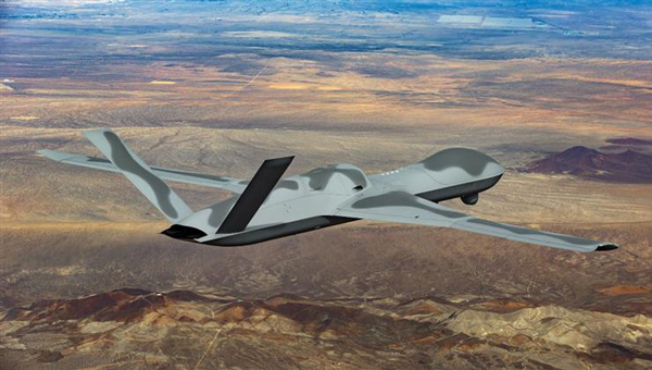
One of the top dogs in the mil-spec UAV world, General Atomics Aeronautical Systems Inc. (GA-ASI) has developed and built several jet-powered demonstration UAVs known as the MQ-20 Avenger, which is currently being used to test out new U.S. Navy communications systems. Derived from the MQ-1 Predator and MQ-9 Reaper, the Avenger is equipped with a Pratt & Whitney turbofan jet engine, allowing it to reach speeds of around 400 Knots at an altitude of up to 50,000 ft.
Predator C Avenger UAV. (Photo: GA-ASI)
After extensive testing since its first flight in April 2009, a larger extended range (ER) version began test flights in 2016. The extended range version has longer wings and an increased fuel capacity with a range of 2,000 miles and an endurance of 20 hours. Avenger has several stealth features, including an S-shaped engine exhaust and an internal weapons bay for precision weapons and sensor packages, similar to the F-22 Raptor and F-35 Lightning front-line fighters. Another recent project saw F-35 technologies passed onto the same jet-powered UAV platform.
The recent Navy communications trials were used to prove the new space-based comms capability and to remotely adjust Avenger’s autonomous internal navigation system while in flight. The aircraft has been designed for long-range, high altitude, speedy, autonomous penetration of enemy areas and this latest capability allows operations where the run-in-to-target phase can be redirected in the very last minutes of an attack. Enemy radar tracking and defenses might, therefore, be misaligned at a crucial phase of an incoming drone alarm without sufficient time to re-align and protect the actual target.
Space-based communications, in this case, used signals via the Proliferated low-Earth orbit (LEO) system of satellites, which is reportedly a mil-spec LEO constellation of communications. satellites — somewhat related to the orbits of the Space-X commercial Starlink LEO internet satellite system.
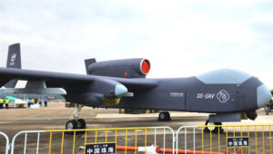
While we are in the military domain, a recently displayed Chinese development is being claimed to be a jet-powered ‘mothership’ UAV. The concept is that the carrier aircraft travels longer distances and releases a swarm of short-range drones when within range of their target(s) — a possible mock-up of such a vehicle was shown before a recent Chinese airshow.
Jiu Tian mothership UAV mock-up. (Photo: Chinese internet)
The center section of the UAV appears to be detachable or has large opening doors – the Chinese and English inscriptions on it imply that it is a module for carrying drones. There have been other reports that Chinese military thinking includes the deployment of large swarms of drones to attack multiple targets simultaneously. However, The Jiu Tian UAV does not come with a stealthy design.
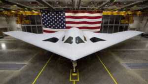
In light of the recent competition between the U.S. and China, an article about the new U.S. Air Force B-21 stealth bomber has been published. The article suggests that, given the F-35 stealth fighter-bomber’s exceptional stealth capabilities and its ability to carry and release multiple weapons from an internal bay, the B-21 may already face obsolescence.
So then, why not re-purpose the B-21 to be a drone-carrying mothership that could, while undetected, penetrate enemy defenses to release swarms of U.S. attack drones?
B-21 next generation Stealth bomber. (Photo: U.S. Air Force)
Currently, a part of the U.S. three-pronged nuclear delivery deterrents alongside submarines and ballistic missiles, the Air Force believes that the role of the existing B-2 Spirit bomber is not obsolete, and the B-21 should become operational as planned in the 2030s with its new stealth and suite of high-end technology sensors and control systems.
The concept of a Chinese “mothership” is designed to transport drone swarms close to targets before launching them. Additionally, there may be a stealthy response from the US, utilizing low-Earth orbit (LEO) satellites for space-based communications to adjust the routing of autonomous drones. This approach raises the question of whether it could be used to deceive drone defenses during the terminal phase of an attack. These solutions are complex but could significantly enhance the effectiveness of future military drone operations.
This month, we have developments across the globe, with drones inspecting power distribution systems and nuclear waste disposal in the United Kingdom, counter UAS (C-UAS ) systems deployed in Greece, and news of cutbacks in the UAV industry affecting two major suppliers.
UK Turns to Drone Power
The UK has reduced coal power generation significantly since 2013 by increasing use of natural gas, nuclear power and renewable sources. Power is distributed throughout the UK by the National Grid Electricity Transmission (NGET) via 4,000 miles of overhead high-voltage lines carried on 21,900 steel pylons. With another 330 substations to also look after, the infrastructure for power distribution in UK always has required a huge maintenance effort. This picture is likely reflected in the power distribution networks of most countries around the world.
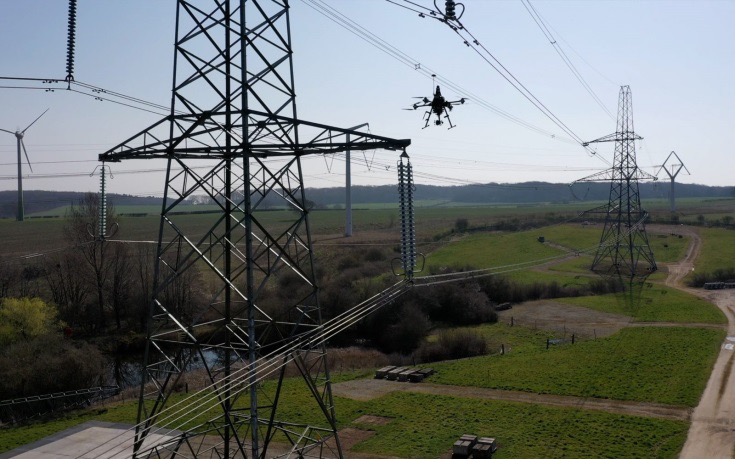
Helicopters have carried a large portion of the workload to enable inspection of cables and insulators, with additional necessary manual inspections taking significant effort to gain access and analyze data. Helicopter time is expensive, and manual inspection processes and data analysis are tedious and time consuming.
Drones are being used for power-line inspection — flown manually by onsite operators — by many organizations in several countries around the world, including by FPL in Florida. But the real reduction in time and effort comes from automating the whole process, and gathering data that provides the detail necessary to assure defects are detected and operational integrity is maintained. The automation of data analysis and generation of useful reports is another area which could yield major savings, and bring rapid focus to areas needing immediate corrective action.
A pylon inspection automation. (Photo: NGET)
Hence, a 12-month trial is being undertaken involving ultimate approval by the UK Civil Aviation Authority (CAA) for beyond-visual-line-of-sight (BVLOS) multiple drone operations. Artificial intelligent (AI) analysis tools are being developed to determine critical changes in collected visual, lidar and positioning inspection data that might herald deterioration in pylon or other infrastructure components.
During an initial test in Nottingham, an autonomous drone was dispatched with minimal instructions. It was able to find its inspection target and complete the programmed inspection in a few minutes. A manual inspection could take up to an hour for the same task. If things go well, it is not impossible to be able to project multiple drones operating with minimal human control, taking on huge swaths of pylons, cabling, insulators and other elements during regular inspections, saving a lot of time and money.
The trials so far have also included remote inspection of the Sellafield nuclear waste decommissioning site, rail infrastructure and a telecommunications network along with investigations towards transport of medical supplies.
Sellafield is where spent fuel ends up from the UK’s 31 nuclear power plants. Also, nuclear waste from reactors in neighboring European countries is reprocessed here. Nuclear waste is processed into 50-ton concrete blocks and spent fuel is “vitrified” into huge chunks of glass, which are encased in an outside metal jacket. Both processes minimize any emitted radiation and allow the contents to safely cool over long term. The staff uses robots inside the facility to remotely dismantle contaminated areas and load material into 55-gallon drums, which might be further processed by robot crushing machines. No one has any real idea how all this nuclear waste could be permanently disposed of, but it’s possible most will ultimately be buried in the ground.
This type of power might seem a “green” boon for humanity, but in a somewhat countrified area on the West Coast of England and in other similar sites around the world, nuclear waste disposal is costly and very, very long-term. The half-life of uranium is between 159,200 years and 4.5 billion years. Monitoring the waste could be a long-term task for drones, such as those now used to detect radiation inside the Fukushima nuclear plant. Certainly, there’s plenty of time to evolve improved drone detection capability for radiation monitoring.
Greece Employs Counter-UAS against Turkish Incursions
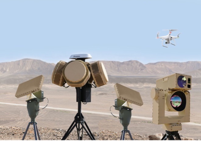
On a defense-related note, apparently the long-running rivalry between Turkey and Greece is, unfortunately, continuing. It seems that Turkey has been repeatedly flying its Baykar-TB2 surveillance drone over Greek islands, perhaps to monitor the movements of Greek warships or island defense installations. And Greece is a little bit more than peeved.
Having established a defense-related relationship with Israel in 2021, Greece has brought Israeli drone defense systems to the Greek islands, installing a “veritable umbrella against enemy unmanned aerial vehicles.” The Israeli system has a number of moving parts: detect and identify; generate related alerts; a directional jamming system that can disable drones in flight (presumably by jamming GPS or the control link); and a laser that can lock onto a small target and, if manually fired, can apparently destroy an intruder drone.
DroneDome elements (Photo: Rafael Advanced Defense Systems)
Because of the directional, narrow beamwidth of the jammer, Rafael claims that the system can be activated within crowded civilian airspace without affecting the navigation of other users. Good news for Greece and their popular, attractive Greek island tourist destinations.
UAV Defense Contractors Struggle — with Each Other
Meanwhile, current economic uncertainty is apparently impacting at least a couple of UAV defense contractors: Boeing/Insitu and Orbital UAV. The two made news when Orbital, as an Australian public company (ASX symbol OEC), had to halt trading. The company was then able to reinstate trading largely because of news of cancellation of a development/production agreement with Insitu.
Apparently, Orbital has previously been delivering two-engine versions to Insitu and was contracted to develop and deliver a third derivative engine. However, Insitu had to scale back Orbital’s work in February, given its sales of the popular ScanEagle and other UAVs may have fallen off in recent months.
Orbital UAV Propulsion System (Photo: Orbital)
This has affected Orbital’s revenue forecast for the year. The company now expects to lose AUD $7 million for the year. It has subsequently prepared a claim under the supply agreement for Insitu’s Termination for Convenience of AUD $1.8 million in costs incurred in the development of the third engine program, which Insitu/Boeing disputes. There will obviously be some wrangling, but hopefully both parties will settle things amicably so as not to damage their ongoing relationship for supply of the existing two engine types.
ScanEagle UAV (Photo: U.S. Navy)
To sum up, for this month we have a trial in the UK which will hopefully lead to significant savings in effort and costs for ongoing power infrastructure inspections, along with some background on UK nuclear waste disposal. Greece is bristling and defending against unwanted Turkish drone overflight using Israeli C-UAS systems. Finally, there’s somewhat negative news for the Orbital UAV engine and Insitu ScanEagle relationship — apparently, not everything in the UAV garden is roses.
Lynx–Lawrence & Mayo, an Indian engineering equipment providers, has expanded its portfolio to include specialized drones, through its partnership with ideaForge, India’s largest UAV manufacturer.
As part of the agreement, ideaForge’s drones equipped with more than a decade of UAV design expertise, will be accessible to Lynx – Lawrence and Mayo for applications across urban development, weather monitoring and testing, agro-technology and other sectors.
Developed by a team of Indian Institute of Technology Bombay graduates, ideaForge has been celebrated for its innovations in the unmanned aerial vehicle (UAV) domain. It built a small, light autopilot in 2009 and India’s first autonomous quadcopter UAV. Their designs have led the development of world class, indigenous UAVs for security and surveillance, reconnaissance, mapping, photogrammetry and other industrial applications. Now, their UAVs even come with the capability to meet the DGCA regulations, to ensure NPNT compliance.
Through this partnership, Lynx–Lawrence & Mayo will have access to ideaForge’s fleet of UAVs for inspection, surveillance, traffic and crowd management, and disaster management. The fleet includes:
Switch UAV – A fixed-wing vertical take-off and landing (VTOL) hybrid for terrain-independent deployment with long range, high endurance and high altitude capabilities.
Q-Series UAV – Enterprise specialist VTOL quadcopter built with military design philosophies.
Ninja UAV – Lightweight and economical micro UAV built specifically for mapping and advanced surveillance.
Netra Pro – Rugged quadcopter for maximum redundancy in extreme conditions.
Netra V-Series – Field-proven UAVs for mission-critical applications, integrated with high zoom HD real-time video transmission.
“We at Lynx have been driving innovation and excellence in advanced precision equipment for engineering and industry. With the addition of innovative UAVs from ideaForge, we are delighted to add a range of advanced and futuristic drones to our portfolio,” said Glenford D’souza , Lynx senior general manager. “We will be strategically deploying these products to create an integrated and specialised service/solution offering to our existing and potential clients. We look forward to a long term and fruitful partnership.”
IdeaForge has deployed more than 700 systems and has trained more than 1,200 pilots in services including the Indian Army, Navy and Air Force; state police forces; Indian railways; and many more agencies.
IdeaForge drones have been used in defense and homeland security for border monitoring, anti-terror operations, counter insurgency operations, disaster management, traffic monitoring, campus surveillance, crowd management and more.
With the flexibility to customize their drones for an array of requirements, ideaForge also provides end-to-end UAV solutions and services to the industrial and commercial sectors.
Raytheon Company has signed a strategic agreement with AirMap, an airspace intelligence platform for drones, to collaborate on projects to safely integrate unmanned aerial systems (UAS) into the national airspace system. This will help unlock the positive economic and social benefits of expanded commercial drone operations, the companies said.
Unmanned air traffic control advances will unlock safe, efficient and scalable drone operations with a myriad of economic and social benefits.
“AirMap is ushering in a new era in drone aviation,” said Matt Gilligan, vice president of Raytheon’s Intelligence, Information and Services business. “Drones must safely operate in an already complex ecosystem, which is where our experience matters.”
The agreement combines the two companies’ expertise:
Raytheon’s Standard Terminal Automation Replacement System, or STARS, is used by air traffic controllers across the U.S. to provide safe and efficient aircraft spacing and sequencing guidance for more than 40,000 departing and arriving aircraft daily at both civilian and military airports.
AirMap is a global provider of airspace intelligence for UAS operations, with over 250,000 registered users. In 2018, U.S. registered commercial drone pilots used AirMap to request more than 45,000 automated authorizations to fly in controlled airspace.
“Raytheon technology has helped safely and effectively manage airspace in the most complex, dense controlled airspace in the world for decades,” said Ben Marcus, AirMap co-founder and chairman. “They are an ideal partner to join AirMap on the path toward enabling safe, efficient, and scalable drone operations in U.S. low-altitude airspace between 0 and 400 feet.”
The two companies are working toward an integrated demonstration that will showcase how AirMap’s unmanned aircraft traffic management platform can increase air traffic controllers’ awareness of potential conflict between drones and manned aircraft near airports to ensure overall safety of the airspace.
This year’s AUVSI Xponential show continued to demonstrate how large, thriving and visionary the UAV market is proving itself to be. With attendance around 8,000 people, an extensive technical program featuring more than 300 speakers, and a huge show floor displaying a wide range of sizes, configurations and applications, this was truly 2019’s place to be, see and — for the exhibitors — be seen.
On the large-format side,
an expanding test-range facility in North Dakota brings experimental capability to the oversize crowd,
Bell and Boeing are going full-tilt with large UAVs, both rotor and fixed-wing, and
a higher level market is emerging at 20 kilometers (12 miles, or 65,000 feet) above the Earth.
In the smaller-sized portion of the market, hydrogen fuel cells are extending operational time, and indoor inspections can be significantly cost- and time-reduced with new task-specific models.
Hurricane Irma response. Tuesday morning’s opening keynote featured an overview of how Florida Power and Light (FPL) and Precision Hawk undertook recovery inspections following Hurricane Irma in 2018.
This rang a bell for me, as Irma was the first hurricane I lived through; it passed 30–50 miles to the east of us, up the center of Florida.
FPL flew 4,000 miles with Precision Hawk drones, looking for downed and damaged transmission lines and blown transformers throughout its massive distribution network.
UAVs on the Show Floor
With roughly 800 exhibitors, it’s impossible to see everything, let alone talk with all the companies. So the following is a small subset from the show, with highlights from the large-format UAV sector and a few smaller ones. Further coverage of the show will appear in next month’s newsletter column.
The Bell Nexus demonstrator drew crowds at AUVSI Xponential 2019. (Photo: Tony Murfin)
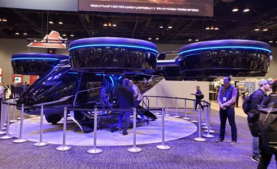
Bell Helicopter. The Bell Nexus demonstration tilt-rotor – judging solely by the number of smartphone picture takers – was the hit of the show.
Nexus is gleaming blue, with six 8-foot tilt-rotors. The booth had a massive display screen in the back running a loop of its exploits, along with what seemed to be animations of future adventures — flying people around city-center skyscrapers.
Tail-sitter package delivery drone. (Photo: Tony Murfin)
This brings up lots of potential failure modes to be mitigated (six rotors rather than one regular helicopter rotor blade and a complex control system, for instance) for the Federal Aviation Administration (FAA) to chew on during the certification process.
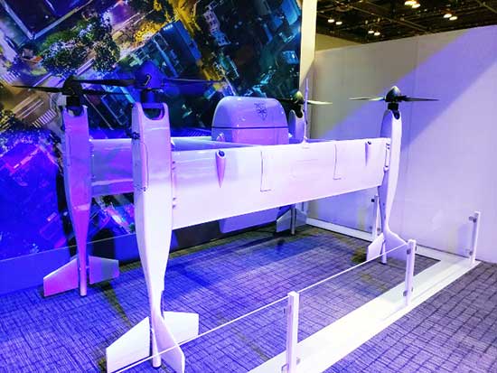
A large four-tail package-carrying sitter drone for larger item deliveries took second place at the Bell booth, even though it is possibly closer to becoming a reality than the gleaming blue star of the show.
Boeing’s tilt-rotor UAV prototype recently flew its first test flight. (Photo: Boeing)
Boeing. Meanwhile, Boeing was apparently preparing to fly a prototype version of a tilt-rotor UAV, only Boeing’s is designed to be a heavy cargo lifter. The Cargo Air Vehicle prototype vehicle has six tilt-capable dual-rotor systems, weighs 1,100 pounds and is 17.5 x 20 x 5 feet tall. It’s interesting how similar the Bell and Boeing (production concept) configurations seem to be.
Boeing design concept for the Cargo Air Vehicle. (Image: Boeing)
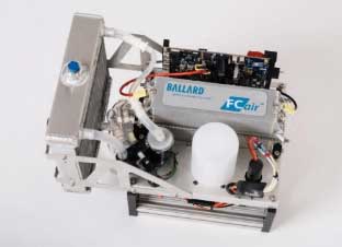
Ballard. Most multi-rotors on UAVs are driven by electric motors, so battery capacity determines the duration of flying time. Ballard has developed the FCair hydrogen fuel cell, which can extend flight time to up to 90 minutes, almost three times that of lithium-ion battery-powered drones.
FCair 600W hydrogen fuel cell. (Photo: Ballard)
Insitu, AeroVironment, Lockheed-Martin, and others have flown the Ballard fuel-cell system; apparently this list also includes the U.S. Naval Research Laboratory and the Air Force.
Grand Sky. The Grand Sky Aviation Park in North Dakota is co-located within the 217 acres Grand Forks Air Force Base (AFB) and has FAA approval as a UAV beyond-visual-line-of-sight (BVLOS) test range.
North Dakota has invested more than $34 million in UAV efforts within the state, with a good chunk going towards the infrastructure at Grand Sky. Now only UAVs fly out of the facility, with Northrop Grumman and General Atomics making it an operational base for Global Hawk, Reaper and Predator drones.
One of the principal benefits is the ability to fly BVLOS operations for large drones at Grand Sky. The system uses two long-range primary radars, one at Grand Forks AFB and the other in Hillsboro, that can detect non-cooperative aircraft.
Harris RangeVue radar and Harris ADS-B sensors coupled with the Air Force’s DASR-11 radar enable BVLOS testing without using a chase plane or staying within line-of-sight. This enables 10–12 hour missions within the 30-mile, 18,000-foot BVLOS range, with continuous electronic monitoring by the ground-based radar system.
A new operational center is being built to house the integrated system and to provide access for visiting drone operators, and the BVLOS range is expected to be ultimately extended all the way to the Canadian border.
Flyability. The Elios 2 UAS system has evolved to include a rotatable thermal and high-definition visual camera payload, 10,000-lumen oblique lighting system, and reversible rotors that enable the UAV to back out of tricky situations.
A geodesic-like cage surrounding the drone makes it collision-tolerant and enables flight in restricted indoor areas such as refinery enclosures, mines, vats, cargo holds and nuclear containment vessels — anywhere, in fact, that inspections today are regularly conducted by people.
A typical nuclear plant inspection might cost $500,000, while this drone system costs around $35,000, and an inspection might take around 10 minutes. For traditional inspections, plants might have to go offline completely while people crawl around in extremely difficult, often dangerous spaces, and manual reports might take significant time to produce.
Flyability claims huge savings in inspection time with their system, as well as automated analysis and production of reports.
AeroVironment. Just before the show, SoftBank, Japan and AeroVironment held a press conference in Japan outlining their HAPSMobile Joint Venture to address the lack of communications access in many parts of the world. Almost 3.7 billion people, or half the world’s population, currently do not have internet access.
SoftBank wants to provide internet inexpensively, without the need for extensive ground infrastructure, by operating high-altitude pseudo-satellite (HAPS) UAVs. HAPS is expected to fly in the stratosphere at a 20-kilometer height for up to six months, powered by solar cells and equipped with payloads that enable direct connection to the internet for users on the ground.
Airborne-type certification and spectrum will be required for the uplink/downlink. Both present significant challenges, but HAPS suppliers, including Airbus, Facebook and others are joining the fight for spectrum. AeroVironment has a $65 million contract from HAPSMobile to develop and produce HAPS UAVs, and build of their Hawk 30 HAPS UAV is well underway.
HAPSMobile has also taken a minority $125 million position with Loon, which has been flying stratospheric balloons for several years, providing wireless coverage in Puerto Rico after Hurricane Irma, and network coverage in South America.
Other suppliers exploring the HAPS market at the show included Airbus, which displayed its Zephyr UAV and recently announced the opening of the Wyndham HAPS launch site in Western Australia; and UAVOS, which announced a new control system for its HAPS vehicle.
In addition, Boeing’s unmanned aircraft subsidiary, Aurora Flight Sciences, has already made significant claims about the capabilities of its own Odysseus HAPS UAV program.
Recapping the Recap. With many more exhibitors and limited time, the rest of the story from Chicago’s 2019 Xponential exhibition will have to wait till next month, to include show news from Sagetech, uAvionics, Sensefly, Fortem, Septentrio, NovAtel and others.
In sum, we see a wide range of different applications all benefiting from unmanned air vehicles of different types and configurations. A number of outfits are working the HAPS gamble, North Dakota’s BVLOS test-range expansion brings experimental capability to the oversize crowd, and Bell and Boeing are going full-tilt with large UAVs, both rotor and fixed-wing.
These developments clearly indicate that the UAS business continues to grow into a huge number of applications and to look very healthy.
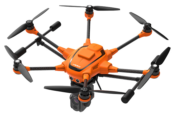
Yuneec International’s commercial hexacopter, the H520, will now optionally be available with an RTK (real-time kinematic) system from the Swiss company Fixposition.
Under difficult GPS conditions, such as in cities or canyons, the RTK system ensures maximum precision and centimeter-precise positioning. The fully integrated RTK satellite navigation enables extremely accurate recurring images and faster 3D mapping. It also makes automated inspection flights easier and more precise, the company said.
The new H520 RTK is suitable for commercial applications that require maximum precision. By using RTK technology, the H520 can now fly much closer to objects for inspection as the UAV positions itself precisely in the centimeter range (1 cm + ppm horizontal / 1.5 cm + ppm vertical) rather than in the meter range, which is standard for the H520.
This accuracy is paramount for applications where several images need to be taken at the same location on different days including:
documenting progress on construction sites,
inspecting mountain landscapes to prevent natural hazards such as rock falls or avalanches, and
forensic accident scene reconstruction.
In addition, the satellite navigation system makes it possible to significantly reduce image overlaps, which means fewer photos and shorter model calculation times, maximizing efficiency in workflows.
The RTK system is not only fully integrated into the hardware, but also into the UAV’s software. This means the user retains the full range of functions of the DataPilot software, including mission flights.
The H520 RTK works with two components: the RTK module on board the H520 and a base station on the ground. For precise navigation, the module supports constellations of up to three different satellite systems from GPS, GLONASS, Galileo and BeiDou.
If the use of a ground station is not possible, the system can also be operated with a national reference station network (network RTK). The network RTK is provided by third-party providers and requires an internet connection, such as a mobile hotspot. All data including satellite data is recorded, which makes the H520 RTK suitable for post-processed kinematics (PPK).
The H520 RTK will be available in the second quarter of 2019. Technical specifications are available here.
The first European Drone Summit will take place Oct. 15 in Frankfurt, Germany, to bring together stakeholders to discuss the future of drones in Europe. The summit is sponsored by UAV DACH e.V. and Interaerial Solutions of Intergeo.
In addition to being a smart, up-and-coming technology, commercial drones are also an integral part of the digitalisation of business and society. The EU member states have agreed to introduce legislation regulating the operation of unmanned aircraft in Europe that takes into account both economic potential and safety requirements.
The programme will be put together by UAV DACH experts and will explore legal aspects, technological issues and various application areas. Legislators, industry representatives and user groups will meet on the eve of Europe’s largest trade fair for commercial drones.
The following experts will speak (with more to be named later):
Peter van Blyenburgh, UVSI
Max Scheck, Vereinigung Cockpit
Jules Kneepkens, EASA a.D.
Martin Brandenburg, DJI
Andreas Lamprecht, AIRMAP
Jörg Seebach, DeDrone
UAV DACH is an association for commercial unmanned aviation in Europe. It represents the interests of 175+ corporate members from research, manufacturing and application located in Germany, Austria, Switzerland, Italy, Spain and the Netherlands.
The Interaerial Solutions part of Intergeo is the largest commercial drone trade fair in Europe. It takes place Oct. 16-18, also in Frankfurt.
Assessing the health of an entire industry is not an easy task, but talking with industry leaders and looking for examples of growth and investment can help.
Our “State of the UAS/UAV Industry” inquiries have lead to discussions with General Atomics, Association for Unmanned Vehicle Systems International (AUVSI), Aeryon Labs and SensoFusion. SensoFusion might be a little well less known that the others, but we felt the need to include the views of an anti-drone system supplier to counterbalance the industry’s perception of itself.
Discussions included questions around the following issues:
The level of maturity of common technologies in use on UAV platforms and systems?
The level of maturity of integration of those technologies?
A sketch portrait of the industry?
Rough numbers or percentage of small players versus large ones?
The rate of consolidation of companies (has it happened or has it yet to happen?)
The financial underpinnings of the market — does it have real “legs” or will it be like the first Internet boom/bust?
If we start with a top-level overview of the industry, as a whole we find that on the commercial side it’s an industry trying to figure out what it is and who its customers might be. But there is also a well-established military part of the industry that is quite mature. A large number of multi-rotor UAV suppliers use simple handheld controllers, all aimed at different applications where they are seeking a niche. The FAA’s release of regulations last year for use of small unmanned vehicle systems (sUAS) has provided a real boost to many more commercial pay-for-service ways these vehicles are now being used.
Multi-rotor UAVs are being put to use in surveying, filmmaking, newsgathering, real estate, crop and pipeline inspection, firefighting, law enforcement, security, search and rescue, and disaster monitoring and relief, just to mention a few applications. And, of course, home/hobby flying your own drone in your backyard or open areas has fueled the Chinese DJI drone manufacturers’ growth significantly. While the FAA requires registration of these private drones, it has not prevented an increase in commercial passenger aircraft pilot reports of UAV incursions into controlled airspace, which appear to be on the increase.
Then there are small, medium and large fixed-wing UAVs that appear to have been mostly developed for and used by the military. Hand-launched surveillance drones for small groups of ground troops; mid-sized, longer range surveillance drones finding applications in commercial inspection; and the bigger General Atomics Predator type aircraft which have become the U.S. military’s search and destroy long-range vehicle, which can carry significant ordinance. At the top end, we have UAVs like Global Hawk which are used for very high altitude, long-endurance surveillance. Not forgetting target drones like the Northrup Grumman BQM-74E, which earns its living pretending to be an enemy anti-ship cruise missile for the U.S. Navy.
Global Hawk (Photo: USAF)
BQM-74E target drone.
Commercial Growth Anticipated
Brian Wynne, president and CEO of the Association for Unmanned Vehicle Systems International (AUVSI), believes for the commercial segment that, “The UAS industry is primed for incredible growth. UAS are being used in all 50 states by industries like real estate, agriculture and the oil and gas industry for more than 40 different types of business applications, including aerial photography, emergency management and utility inspection.”
More than 500,000 people have registered their UAVs with the FAA in the U.S., and around 20,000 of those are looking to start commercial operations. AUVSI expects more than 100,000 jobs will be created when UAS are integrated into and allowed to operate in the U.S. National Airspace System (NAS).
However, Wynne went on to comment, “This this can only happen if the government puts in place a true, holistic plan for full UAS integration that includes flights over people, as well as beyond line-of-sight operations, access to higher altitudes and platforms above 55 pounds.” AUVSI estimates that in the first decade after full UAS integration into the NAS, these commercial operations could generate more than $82 billion is economic impact.
Even before the FAA’s release of formal regulations (known as Part 107) for use of sUAS in June last year, more than 5,500 businesses received approval to fly for commercial purposes. AUVSI published a report that analyzed these applications — the analysis provides an overview of the developing commercial UAS industry in the U.S.
AUVSI analysis of initial UAS applications.
Over 90 percent of these businesses make less than $1 million in annual revenue and have fewer than 10 employees. This also provides an indication that the engine behind this growth comes from small, independent business.
Nevertheless, big organizations such as CNN are also exploring visual line-of-sight operations over people and safely using UAS for newsgathering in populated areas. PrecisionHawk is testing extended visual line-of-sight operations in rural areas, aimed at precision agriculture, and BNSF Railway is testing beyond visual line-of-sight (BVLOS) operations, in rural and isolated areas, for the inspection of rail system infrastructure. These tests are being conducted as part of the FAA’s Pathfinder Program.
More recently, anti-drone systems have joined the party to help defend against unwanted UAV incursions into secure areas already protected by conventional systems like radar, acoustic and optical detection systems. Secure areas include such places as prisons, government buildings/facilities, utility companies (including nuclear power stations) and airports. Sensofusion in Finland is one such company, with its Airfence anti-drone system — one of three anti-drone systems tested last November by the FAA at Denver airport. The other systems were supplied by CACI International and Liteye Systems.
Kaveh Mahdavi, VP of Operations for Sensofusion, thinks that, relatively speaking, the UAV industry is quite mature — what’s still being developed are systems to enable autonomous drone flight. The regulations published so far only address ground-pilot-controlled operations, even though BVLOS testing is progressing well.
Anti-Drone Systems
On the other hand, the maturity level of anti-drone systems range from proven to embryonic. As many as 50 companies with different technical solutions are vying to succeed in this new segment. But as the UAV segment continues to grow, so does the need for detection and prevention of drone incursions.
These systems employ three basic technologies: radar, optical and RF. Radar and optical need direct line of sight and cannot see “over the horizon.” That makes them quite short-range, and detection and defense has to be exceptionally quick to prevent unwanted UAV flying visits. Whereas, the Airfence RF system is omnidirectional and can even detect UAS preparing for take off up to six miles away, as demonstrated at the Denver airport.
So, intrusion warnings at a geo-fence distance of, say, 3-4 miles can be generated, and automatic defense/prevention is readily achieved. For instance, some utility companies want to have detection, warnings and control of intruder drones within a mile of their facilities.
Mahdavi went on to describe how Airfence uses a library of drone control RF signatures for all known UAS, with new signatures being added on a regular basis. They can detect, intercept and directly take control of the offending vehicle. During the Denver tests, Airfence initially only detected one third of the target UAVs, but the RF signatures of all targets were acquired. Then, using remote engineering updates to the library, by day three all were detected. With lower prices, consumer drones are becoming a real threat for these sensitive areas.
The anti-drone industry will no doubt face considerable consolidation over the next couple of years, but Mahdavi feels that Sensofusion is well placed with significant military and government business, which is funding their growth without external investment. “Securing the right contracts with the right customers,” as he says, has well positioned the company for now and the future.
General Atomics Aeronautical Systems Inc. (GA-ASI), makers of the well-known Predator, Reaper and other Medium-Altitude Long-Endurance (MALE) drone systems, has been in this business for almost 25 years. GA considers its products to be proven, mature and resilient for the military and government markets that demand them to be so. The company uses “best of breed” in-house products and technology across the range of air and ground systems that make up its highly successful drone systems.
In an effort to align with European customer interest, GA-ASI has been investing in a “certifiable” version of the Predator-B, recently named SkyGuardian. A derivative for marine applications will be known as the SeaGuardian.
SeaGuardian.
SkyGuardian.
Just as military transport aircraft want to transit through civilian airspace and, in order to do so, have been equipping with certified navigation systems for a number of years, military drone operators want to be compatible with Europe’s high-density commercial flight regulations and to operate within existing air-traffic control corridors. To arrive in time for these European programs, GA-ASI has invested to get ahead of the market. This has entailed assessment of all on-board and ground components, and has led to upgrades and re-designs where necessary.
“Nevertheless, on existing product lines, there is a large degree of commonality across common systems on multiple platforms,” said Mike Cannon, VP of international programs. Common systems include datalinks, power avionics, de-icing systems, and some airframe components.
GA-ASI has developed and integrated its own flight control system in its aircraft for more than 20 years. This has proven to be a key element of the success for the Predator family of products. Because all these systems have been flying for so long, they have been proven and become very reliable, dependable elements of the company’s unmanned systems.
Having said that, Hughes Network Systems has just announced that its Defense and Intelligence and Systems Division (DISD) has been selected by GA-ASI to provide satellite communications on the “Type-Certifiable” Predator B Remotely Piloted Aircraft (RPA) system. Working with GA-ASI, Hughes will customize the aircraft’s satellite communications system with modified Hughes HM series modems. The advanced modems will enable a significant increase in data transfer rates, using an enhanced waveform that ensures resilient and secure communications when operating in challenging environments.
So, its very difficult for new start-up companies to enter this top level segment of the UAV market — its very expensive to develop, demonstrate and prove large airframes, control systems and avionics that customers can rely on. GA-ASI has a unique position alongside major suppliers such as Boeing, Northrup Grumman, Israel Aerospace Industries (IAI), and Lockheed Martin — however, Chinese UAS are beginning to show up in the marketplace, apparently as a result of significant, focused investment.
Nevertheless, with an enviable position as a major supplier of platforms used in multiple applications, with sufficient internal resources to fund their initial vehicle developments, GA-ASI has secured a large number of programs with multiple follow-on orders and funding for increasingly more capable derivative UAS. As the company now looks towards the “certifiable” segment using another internally funded product launch, it is again reinforcing its leadership position in its chosen unmanned market segment.
Small UAS by Aeryon Labs
Meanwhile, the world of small unmanned air vehicles (sUAS) continues to thrive, given the release of FAA regulations last year, and many commercial applications are blossoming, using increasingly capable small multi-rotor drones. David Kroetsch, CEO and co-founder of Aeryon Labs in Ontario, Canada, thinks that the sUAS segment is maturing from an early adoption phase into providing utility to a growing number of organizations. Aeryon is an established player in the sUAS market and has been around for more than 10 years, so it has also had time to prove its platforms and internal systems. Aeryon also built its own flight-control hardware and software, which enables the company to gain substantial power savings and get longer endurance from how it automatically manages rotor speeds.
“The quad platform has been around since 1938, so the concept is hardly new; however, over the last decade, Aeryon Labs has substantially matured and ruggedized our platform, the Aeryon SkyRanger sUAS,” said Kroetsch. Their focus is on not only on the UAV platform, but also on supplying complete systems that meet the various needs of their customers. With electro-optical and thermal-imaging camera payloads and an on-board georeferencing data collection/processing system, Aeryon provides integrated solutions for customers, such as AeryonLive Video and Telemetry and AeryonLive Fleet Management using real-time software tools.
Aeryon SkyRanger sUAV.
AeryonLive tools.
For the oil and gas industry, providing compatibility for off-line flight planning software inputs and importing compatible aerial imagery into existing GIS systems is a significant feature for these customers. The SkyRanger UAS has benefited from many years of use in the field, and has been designed with modularity and ease of use with snap-on/off parts that make operating in bad weather a lot easier.
Aeryon’s business is currently 50%military, 25% oil and gas and 25% public safety (such as rapid traffic accident data gathering). Other entrants to these segments might find it easy to put together an unmanned system from parts bought on the internet; what comes considerably harder is proving reliability and interoperability with existing customer systems. Actually, to develop an industrial-grade UAV takes lots of investment and requires experience gathered over many years. Customers have learned how to differentiate between those dabbling in the market and those with serious capabilities.
Consolidation is inevitable in this market segment — perhaps within the next six months, certainly over the next two years — just because there are so many companies trying. Investment is getting harder to find for these start-ups and it may be too late for most, as the leaders are already well established.
“It’s essential to pick a niche within the increasingly competitive UAV industry,” Kroetsch said. “This is why Aeryon chose early on to focus on enterprise-level offerings in commercial, public safety and military.”
Recall what happened to 3D Robotics. Even though 3D Robotics raised many millions in funding, its Solo quadrotor fell from grace, perhaps due to continuing design issues and being higher priced compared to rapidly declining DJI Phantom 3 prices. “‘Competition and consolidation look to be very similar to that which happened with digital cameras,” Kroetsch said.
For Aeryon, being Canadian appears to be an advantage right now, as U.S. export regulations seem to be handicapping U.S. drone manufacturers. Aeryon sells in 35-40 countries because its product does not contain military-restricted components and only uses commercial parts. Canadian regulations for drone system exports do not prohibit world–wide sales for such products, while U.S. regulations can be difficult for U.S. suppliers to negotiate.
Nevertheless, unexpected hurdles to adoption still exist, such as company policies related to health and safety, union restrictions, and potential internal clashes on responsibility for implementation. But with 100% test, and a hardened design for tough environments, Aeryon sees itself well positioned to grow in its chosen industrial sector.
Conclusion
This has been a brief and incomplete overview of the UAV/UAS industry — a first try, if you will. Nevertheless, it’s a summary that we can use a benchmark for where we are right now, and a departure point for future growth.
We have quite mature capability in both large and small UAS, with integration focused on flight-control and navigation systems. The larger UAS enjoy a relatively mature market with established suppliers of lower numbers of expensive systems, while the sUAS segment is larger, younger and less expensive, with not as many barriers to entry.
Nevertheless, there are mature industrial segments with harder, more integrated requirements that make it hard for new entrants to climb the steps into more difficult commercial operations. The recreational segment is dominated by DJI, and it remains strong with well-performing, easy-to-operate drones.
Because of the ease of access to smaller drones, despite FAA and other countries’ regulations, people seem to want to penetrate secure facilities such as utilities, airports, military bases, prisons and other government locations. Therefore, anti-drone systems using optical, radar and RF are becoming available, and facilities are being equipped to prevent unwanted drone incursions.
AUVSI xPONENTIAL
I’ll be roving the show floor at the upcoming AUVSI xPONENTIAL show in Dallas, and I welcome your added insight, from all corners of the UAV industry, for a continuation of this assessment in an upcoming Professional OEM & UAV e-newsletter column (subscribe free at gpsworld.com/subscribe).
The first operational rules for routine commercial use of small unmanned aircraft systems, announced June 21, officially take effect today.
“People are captivated by the limitless possibilities unmanned aircraft offer, and they are already creating business opportunities in this exciting new field,” said U.S. Transportation Secretary Anthony Foxx. “These new rules are our latest step toward transforming aviation and society with this technology in very profound ways.”
“The FAA’s role is to set a flexible framework of safety without impeding innovation,” said Administrator Huerta, Federal Aviation Administration (FAA). “With these rules, we have created an environment in which emerging technology can be rapidly introduced while protecting the safety of the world’s busiest, most complex airspace.”
The provisions of the new rule — formally known as Part 107 — are designed to minimize risks to other aircraft and people and property on the ground. A summary is available.
Effective today, the FAA has several processes in place to help users take advantage of the rule:
Waivers. The agency is offering a process to waive some of the rule’s restrictions if an operator demonstrates the proposed flight will be conducted safely under a waiver. Users must apply for these waivers at the online portal.
The FAA is issuing more than 70 waivers today, based on petitions for Section 333 exemptions. These waivers will be posted on September1. The majority of the approved waivers were for night operations under Part 107.
Airspace Authorization. Users can operate their unmanned aircraft in Class G (uncontrolled) airspace without air traffic control permission. Operations in Class B, C, D and E airspace need air traffic approval. Users must request access to controlled airspace via the electronic portal at www.faa.gov/UAS.
The FAA will evaluate airspace authorization requests using a phased approach. Operators can submit their requests starting today, but air traffic facilities will receive approved authorizations, if granted, according to the following tentative schedule:
Class D & E Surface Area: Oct. 3, 2016
Class C: Oct. 31, 2016
Class B: Dec. 5, 2016
The FAA will make every effort to approve requests as soon as possible, according to the agency, but the actual processing time will vary, depending on the complexity of an individual request and the volume of applications the FAA receives. The agency is urging users to submit requests at least 90 days before they intend to fly in controlled airspace.
The FAA will use safety data from each phase to ensure appropriate mitigations are in place as small UAS operations are integrated into controlled airspace.
Aeronautical Knowledge Test. Testing centers nationwide can now administer the Aeronautical Knowledge Test required under Part 107. After an operator passes the test, he or she must complete an FAA Airman Certificate and/or Rating Application to receive a remote pilot certificate.
It may take up to 48 hours for the website to record that the applicant has passed the knowledge test. The FAA expects to validate applications within 10 days. Applicants will then receive instructions for printing a temporary airman certificate, which is good for 120 days. The FAA will mail a permanent Remote Pilot Certificate within 120 days.
In the future, the FAA also will address operations not covered by Part 107 without a waiver, including operations over people, beyond line of sight operations, extended operations, flight in urban areas, and flight at night.
Part 107 does not apply to model aircraft. Model aircraft operators must continue to satisfy all the criteria specified in Section 336 of Public Law 112-95 (which is now codified in part 101), including the stipulation they be operated only for hobby or recreational purposes. Click here for more information on hobby or recreation uses.
Today, the Federal Aviation Administration (FAA) has finalized the first operational rules for routine commercial use of small unmanned aircraft systems (UAS), opening pathways towards fully integrating UAS into the nation’s airspace.
These new regulations work to harness new innovations safely, to spur job growth, advance critical scientific research and save lives, the FAA said in a press release.
“We are part of a new era in aviation, and the potential for unmanned aircraft will make it safer and easier to do certain jobs, gather information, and deploy disaster relief,” said U.S. Transportation Secretary Anthony Foxx. “We look forward to working with the aviation community to support innovation, while maintaining our standards as the safest and most complex airspace in the world.”
According to industry estimates, the rule could generate more than $82 billion for the U.S. economy and create more than 100,000 new jobs over the next 10 years.
The new rule, which takes effect in late August, offers safety regulations for unmanned aircraft drones weighing less than 55 pounds that are conducting non-hobbyist operations.
The rule’s provisions are designed to minimize risks to other aircraft and people and property on the ground. The regulations require pilots to keep an unmanned aircraft within visual line of sight. Operations are allowed during daylight and during twilight if the drone has anti-collision lights. The new regulations also address height and speed restrictions and other operational limits, such as prohibiting flights over unprotected people on the ground who aren’t directly participating in the UAS operation.
The FAA is offering a process to waive some restrictions if an operator proves the proposed flight will be conducted safely under a waiver. The FAA will make an online portal available to apply for these waivers in the months ahead.
“With this new rule, we are taking a careful and deliberate approach that balances the need to deploy this new technology with the FAA’s mission to protect public safety,” said FAA Administrator Michael Huerta. “But this is just our first step. We’re already working on additional rules that will expand the range of operations.”
Under the final rule, the person actually flying a drone must be at least 16 years old and have a remote pilot certificate with a small UAS rating, or be directly supervised by someone with such a certificate. To qualify for a remote pilot certificate, an individual must either pass an initial aeronautical knowledge test at an FAA-approved knowledge testing center or have an existing non-student Part 61 pilot certificate. If qualifying under the latter provision, a pilot must have completed a flight review in the previous 24 months and must take a UAS online training course provided by the FAA. The TSA will conduct a security background check of all remote pilot applications prior to issuance of a certificate.
Operators are responsible for ensuring a drone is safe before flying, but the FAA is not requiring small UAS to comply with current agency airworthiness standards or aircraft certification. Instead, the remote pilot will simply have to perform a preflight visual and operational check of the small UAS to ensure that safety-pertinent systems are functioning property. This includes checking the communications link between the control station and the UAS.
Although the new rule does not specifically deal with privacy issues in the use of drones, and the FAA does not regulate how UAS gather data on people or property, the FAA is acting to address privacy considerations in this area. The FAA strongly encourages all UAS pilots to check local and state laws before gathering information through remote sensing technology or photography.
As part of a privacy education campaign, the agency will provide all drone users with recommended privacy guidelines as part of the UAS registration process and through the FAA’s B4UFly mobile app. The FAA also will educate all commercial drone pilots on privacy during their pilot certification process; and will issue new guidance to local and state governments on drone privacy issues. The FAA’s effort builds on the privacy “best practices” the National Telecommunications and Information Administration published last month as the result of a year-long outreach initiative with privacy advocates and industry.
Part 107 will not apply to model aircraft. Model aircraft operators must continue to satisfy all the criteria specified in Section 336 of Public Law 112-95 (which will now be codified in Part 101), including the stipulation they be operated only for hobby or recreational purposes.
Brian Wynne, president and CEO of the Association for Unmanned Vehicle Systems International (AUVSI), issued the following statement:
“Today’s release of the final small UAS rule by the FAA is a critical milestone in the integration process, and a long-awaited victory for American businesses and innovators. It establishes a clear regulatory framework and helps to reduce many barriers to civil and commercial operations, allowing anyone who follows the rules to fly in the national airspace.
“Accelerating civil and commercial UAS operations will not only help businesses harness tremendous potential of UAS, it will also help unlock the economic impact and job creation potential of the technology. Once UAS are fully integrated into the national airspace and become more widely used, the industry will continue to grow as a job creator and generate significant economic impact.
“Our economic report projects that the expansion of UAS technology will create more than 100,000 jobs and generate more than $82 billion to the economy in the first decade following integration. Whether it’s aiding search and rescue missions, advancing scientific research, responding to natural disasters, or helping farmers care for their crops, UAS are capable of saving time, saving money and most importantly, saving lives.
“The final rule allows for many uses of small UAS and a streamlined waiver process to expand applications. We are looking forward to additional rulemaking which has already begun with AUVSI’s support, to enable more complex operations. We need to make sure we are doing all we can to support the UAS industry’s growth and development; otherwise we risk stunting a still-nascent industry and restricting the many beneficial uses of this technology.”
National Association of Realtors (NAR) President Tom Salomone called the rules a win for the industry.
“We’ve worked hard to strike a responsible balance that protects the safety and privacy of individuals, while also ensuring Realtors can put drones to good use,” said Salomone, broker-owner of Real Estate II Inc. in Coral Springs, Florida. “That effort just took another big step forward. The rules unveiled today will help more real estate professionals take flight, making the efficiency and innovation that drones have to offer available to a much broader base of operators.”
The FAA’s announcement marks a long-fought victory for Realtors. Since early 2014, NAR has worked with the FAA and industry partners to integrate drones into the national airspace for commercial use. NAR wrote to the FAA on numerous occasions to weigh in on the final Small UAS Rule, and testified before Congress to support the use of drones in real estate.
Despite eliminating the requirement that operators hold a pilot’s license, anyone looking to fly drones commercially will still have to comply with strict requirements designed to protect people on the ground.
Drones are useful in a number of real estate-related applications, including marketing properties, assisting with appraisals, facilitating insurance claims and overseeing utility work. While many real estate professionals with pilot’s licenses have already put drones to use in these arenas, the new rules are expected to open the door for additional operators to do the same.
Despite the significant progress made in the FAA’s final rule, NAR’s work on this issue will continue. NAR is calling for eased restrictions on a “micro” category of drones; drones in this category weigh less than four pounds and present a much smaller safety risk than certain drones in the under-55 pound category covered by the rule released today.
NAR also believes there is an ongoing need for a drone strategy that allows for “beyond visual line-of-sight” flights, or those where the operator cannot physically see the drone throughout the entire operation. These flights are particularly important for aerial photography across large buildings or tracts of land.
Salomone praised the FAA for their efforts in crafting the rule.
“Getting here wasn’t easy, and the FAA is to be commended for listening to the concerns of real estate professionals throughout the rulemaking process,” he said. “We’re entering a new stage of drone use in real estate, and no doubt there will be additional questions and challenges ahead. NAR will continue educating its members on issues important to the safe, responsible use of drones so they can grow their business and better serve their clients.”
The National Association of Realtors, “The Voice for Real Estate,” is America’s largest trade association, representing more than 1.1 million members involved in all aspects of the residential and commercial real estate industries.
As part of its effort to deliver cost-effective actionable data to enterprise customers, Measure, a drone operator in the United States, has partnered with Canadian drone company Canadian UAVs. Together, the two companies will use drone technology to provide real-time data analysis to businesses in both the U.S. and Canada.
“Measure can now truly offer cross-border drone services,” said Measure CEO Brandon Torres Declet. “As a result of this partnership with Canadian UAVs, we can deliver cost-effective, actionable data to businesses across all 50 states and 10 provinces.”
The partnership between Measure and Canadian UAVs provides businesses with real-time response capability. With Canadian UAVs use of helicopters, fixed-wing aircraft and drones, Measure can now fly anywhere in Western Canada to acquire data for enterprise customers. Both companies conduct flights that are safe, legal and insured using only licensed pilots.
“Measure has a great depth in expertise regarding the American market, as well unprecedented approvals from the FAA,” said Canadian UAVs President and CEO Sean Greenwood. “Teaming up ensures our customers have clarity and piece of mind when it comes to trans-border operations.”