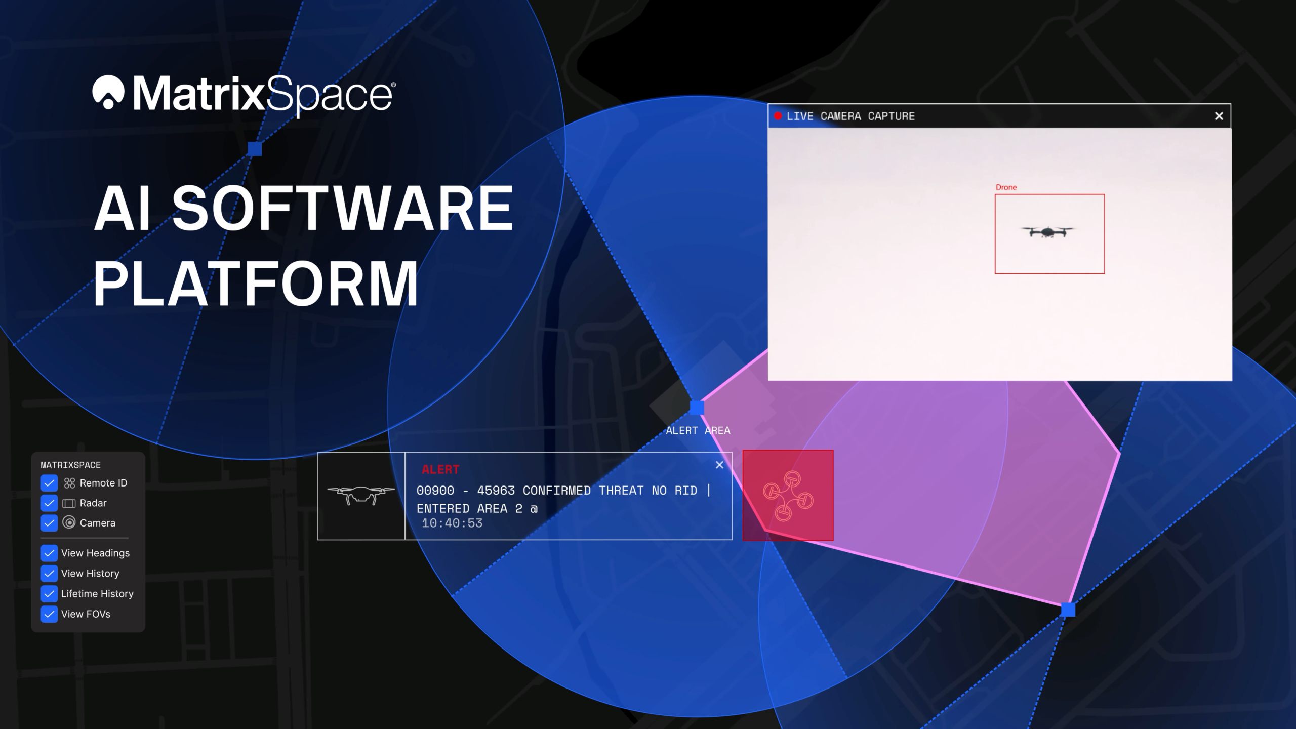
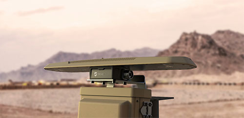
The platform now supports multi-sensor, multi-drone detection in real time for counter UAS applications. It delivers true threat assessment and early warning — detecting, tracking and identifying — to empower on-site and remote operators to make split-second decisions regarding airspace activity. The platform is sensor agnostic and easily integrated into existing systems through open APIs.
The update dramatically improves assessing risk from small, low-flying drones in complex airspace, such as public events, critical infrastructure and battlespaces.
The platform
The MatrixSpace AI Platform consists of MatrixSpace AiEdge, the company’s intelligent sensor operating system, and MatrixSpace AiCloud, a software-as-a-service that collects data from AiEdge-enabled sensors for a unified view of airspace activity. Unlike other offerings retrofitted for AI, MatrixSpace AiEdge and AiCloud are AI-native, making information rapidly actionable and easier to comprehend.
MatrixSpace AiEdge, embedded in every MatrixSpace system, provides actionable intelligence at the point of sensor data collection. It detects, classifies and tracks multiple object types, removing clutter to present a relevant picture of aerial activities, while fusing feeds from different sensors.
AiEdge fuses detections from MatrixSpace radars with complementary sensors such as Remote ID and ADS-B into a single, real-time track. By correlating multi-sensor data at the edge, AiEdge creates a common data representation and cues PTZ (pan-tilt-zoom) cameras for rapid visual confirmation, passing high-confidence tracks to the cloud for enterprise-level analysis.
Sitting above distributed AiEdge deployments, MatrixSpace AiCloud simplifies the management of geographically diverse sensor networks into a single, unified view. Instead of a bank of monitors displaying individual sensor feeds, AiCloud provides operators with clear visibility into low-airspace activity, alerts, and warnings across all protected sites — accessible on any device.
MatrixSpace AiCloud combines fused, real-time data from radar, optical, ADS-B and Remote ID sensors to deliver consistent object tracking and actionable threat intelligence at scale. Within AiCloud, whitelisting and threat classification determine whether objects are friendly, unknown, or hostile, enabling fast, coordinated operator response. Local sensors continue operating autonomously when cloud connectivity is disrupted, with all activity synchronized for review once connectivity is restored.
Winners of the U.S. defense Counter-small Unmanned Aircraft System (C-sUAS) Low-Cost Sensing (LCS) challenge have been announced.
MatrixSpace Inc. was selected as the overall winner and will receive the top award of $500,000. Following the overall winner, the top three performers — Guardian RF, Hidden Level and Teledyne FLIR Defense — will each receive award amounts of $100,000.
The selected systems secured a place among the 10 finalists who advanced to live testing during USNORTHCOM’s Falcon Peak 25.2 exercise, outperforming 115 submissions. The system demonstrated capability in detection, classification, localization, scalability, cost and integration readiness.
Sponsors of the award include Defense Innovation Unit (DIU), U.S. Northern Command (USNORTHCOM), Joint Interagency Task Force 401 (JIATF-401), U.S. Army, U.S. Navy, U.S. Marine Corps and U.S. Indo-Pacific Command.
“Small UAS threats are evolving faster than traditional acquisition cycles, and meeting that challenge requires capabilities that can be deployed at speed and scale,” said David Payne, acting director of DIU’s Autonomy Portfolio. “The selected solutions show how commercial innovation can strengthen our layered defense — delivering affordable sensing that we can field widely, adapt quickly, and keep the warfighter ahead of the threat.”
The MatrixSpace platform combines ultra-low SWaP-C radar, AI-driven edge intelligence, and distributed networked CUAS powered by AiCloud. During the evaluation, it successfully detected, tracked and classified every sortie flown —including RF-dark fiber FPVs, commercial drones, and custom-built UAVs.
A scalable, distributed approach to counter-UAS sensing
The LCS challenge, launched in May 2025, was designed to complement existing sensor systems by identifying emerging technologies that enable broad, distributed, and resilient sensing architectures. During FP 25.2, the 10 selected finalists demonstrated solutions spanning radio frequency passive detection, active radar, acoustic sensing, optical and infrared modalities, and hybrid systems.
These technologies collectively showed potential cost savings of 50–80 percent in total cost of ownership, while still meeting key coverage and performance requirements for C-sUAS defense.
During live testing, vendors were evaluated against a variety of small UAS flown both individually and in coordinated multiples, employing diverse communication protocols. Finalists were not informed which platforms or profiles they would be tested against, ensuring performance was measured under realistic, un-scripted, and operationally relevant conditions.
Evaluated by experts and end-users, against a rigorous selection criteria,challenge winners differentiated themselves by demonstrating tailored technical strengths, high performance against threat-representative UAS targets and demonstrating a cost-effective architecture enabling deployment at scale across fixed, mobile, and austere environments.
About the LCS Challenge
The Counter-sUAS Low-Cost Sensing (LCS) challenge sought to identify emerging sensor solutions that could:
expand detection coverage
reduce total lifecycle cost
integrate seamlessly into joint C2 architectures
provide the resilience and redundancy required to counter small UAS threats.
Launched in May 2025, the challenge drew participation from traditional and nontraditional vendors across the country, representing the full spectrum of sensing modalities. The Falcon Peak 25.2 exercise provided a realistic environment to evaluate these capabilities under operationally relevant conditions.
For more information about DIU’s work accelerating commercial technology into the Department of Defense, visit www.diu.mil.
DroneShield’s RfPatrol MKII body-worn system antennas. (Photo: DroneShield)
DroneShield has received and delivered upon a follow-on order by a U.S. government agency for the company’s portable and handheld counter-UAS (C-UAS) solutions.
DroneShield is the maker of the counter-drone or anti-drone systems including RfPatrol and DroneGun MkIII. It has received contracts from the U.S. departments of Defense and Homeland Security, as well as other federal and state law enforcement agencies.
“We’re grateful for the continued trust that this organization has placed in us to help address a unique set of operational challenges. Our customer relationships are what fuel our commitment to push the boundaries of what’s possible in the counter unmanned space,” said Tom Branstetter, director of business development, DroneShield. “Every teammate at DroneShield understands the significance of the problems we’re solving for our end-users and it’s something we’re proud to support.”
DroneShield also recently announced deployments of its solutions for high-profile events including the World Economic Forum (WEF) in Davos, Switzerland, and IRONMAN Texas 2022.
DroneSentry-C2 with Nearmap location data. (Screenshot: DroneShield)
DroneShield Limited, an Australian/U.S. global leader in artificial-intelligence-based platforms for protection against advanced threats such as drones and autonomous systems, has announced an enhanced version of its DroneSentry-C2 command-and-control software in partnership with location intelligence firm Nearmap.
Nearmap provides city-scale 3D content, artificial-intelligence data sets, geospatial tools, and high-resolution aerial imagery in Australia, New Zealand and North America.
DroneSentry-C2 provides an intuitive and feature-rich software platform, providing counter-UAS awareness and reporting capability. It integrates both DroneShield and third-party C-UAS sensors and effectors. Those include multiple AI-enabled sensing and tracking products, such as RfOne long-range direction-finding sensors for UAS detection and tracking, and camera-agnostic DroneOptID optical/thermal camera AI software.
DroneSentry-C2 will come with a standard mapping solution for cost-sensitive customers, and an optional Nearmap mapping upgrade for mapping data for markets requiring high performance, such as government, intelligence, Homeland Security and defense.
The software comes as an on-premises, air-gapped solution for intelligence, Homeland Security and defense users, or secure cloud for enterprise customers. The on-premises solution also includes a high-grade physical server. Both options come with regular mapping updates, including the ability for the user to load their own maps for sensitive locations.
“One of DroneShield’s differentiators is that we are both a sensor manufacturer and an integrator,” said Oleg Vornik, DroneShield CEO. “Providing a streamlined and standardized hardware / software bundle that gives our user community an easy-to-deploy and run command-and-control software will be critical as more fixed and pop-up site users seek to deploy counter-UAS products. Importantly, the offering is already validated by deployments such as U.S. Air Force and Australian Army, among a number of other tier 1 end users globally.”
DroneShield Ltd. has released CompassOne, a self-contained navigation solution for fixed site, vehicle and marine applications.
The device provides real-time military-grade location, orientation and direction sensing for deployed static and on-the-go assets. The device can be used both in counter UAS systems and general situations requiring satellite navigation.
With a strong focus on durability and ruggedness, CompassOne is suitable for installation and operation in harsh environments. Military-grade (MIL-SPEC) connectors and high-end stainless-steel hardware ensure uninterrupted connection and protection from the elements, while the aluminium underside provides exceptional impact resistance and rigidity while keeping overall weight low.
CompassOne can operate stand alone or integrate with DroneShield’s DroneSentry system. Power over Ethernet reduces cable clutter and VESA compatibility makes CompassOne easy to integrate into new or existing systems. Installation is clear and fast with status LEDs, installation graphics and tool-less fasteners.
“CompassOne, with its ruggedness and incorporation of advanced technologies, integrates seamlessly within DroneShield’s product ecosystem, and equally with third party systems as a stand-alone product,” said Oleg Vornik, DroneShield CEO. “Its accurate navigation is substantially superior to other systems on the market globally.”
The product is expected to be of interest to both counterdrone and other customers requiring a rugged navigation solution.
Counter-unmanned aircraft system (C-UAS) company DroneShield has sold its RfOne MKII long-range sensors to the Australian Army. The capability is being delivered immediately to allow the Australian Army to assess its future counter-drone requirements and options, the company said.
“As an Australian company, DroneShield is immensely proud to support the Australian Army with its long-range counter-drone strategy, said DroneShield CEO Oleg Vornik.
Deployment of the long-range sensors will highlight the flexibility, resilience and capabilities of DroneShield equipment in a dynamic field environment, while also assisting the Australian Army in establishing its counter-drone requirements and future capability options.
The sale, announced July 19, was structured as a one-off sale to the Australian Army. Similar to the standard purchases from DroneShield’s other defence and law enforcement customers, comprises a small purchase of equipment.
Australian counter-unmanned aircraft system (C-UAS) company DroneShield has sold several of its RfOne MKII long-range direction-finding sensors to the Australian Army. The deal, announced July 19. and will “allow the Australian Army to assess its future counter-[UAS] requirements and options”, DroneShield said in a statement, as well as equipping existing platforms with the sensors.
Brazilian Sale
DroneShield also has received formal approval from Anatel, the Brazilian National Telecommunications Agency responsible for issuing the concession of new radio frequencies. Following approval earlier this month, the company has sold a quantity of its DroneGun Tactical units to the Brazilian government.
“Brazil is a large and sophisticated market for military and security equipment, and we are pleased to commence active presence in the country, deploying equipment to the customers,” Vornik said. “We look forward growing our presence in Brazil with the urgent counter-drone requirements mirroring what we are seeing in other countries.”
New Kit
Immediate Response Kit. (Photo: DroneShield)
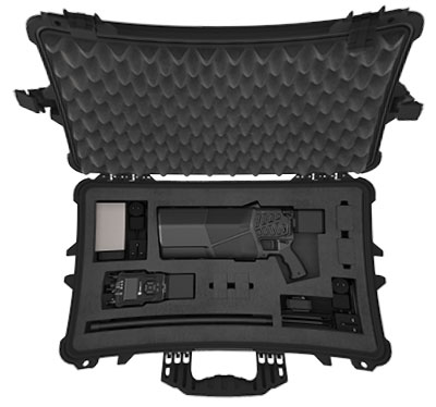
DroneShield also released its Immediate Response Kit (IRK), a rapidly deployable C-UAS detection and defeat kit. The IRK consists of an RfPatrol portable (1.2 kg/2.6 lbs incl battery) detection device and a DroneGun MKIII (2.1 kg/4.7 lbs including battery) defeat device in a rugged carry case.
Both RfPatrol and DroneGun MKIII are currently fielded by military and government customers globally.
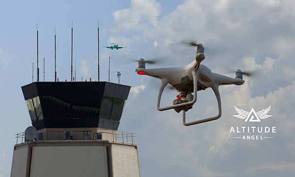
Altitude Angel, a unified traffic management (UTM) technology provider, is bringing to market airspace management solution GuardianUTM Enterprise.
GuardianUTM Enterprise provides a view of the airspace in the vicinity of airports and enables airport to start designing and providing UTM services for drone companies and drone operators, using Altitude Angel’s proven digital authorization and flight-management technology.
GuardianUTM Enterprise will initially be deployed to support regional and local airports and airfields.
Europe’s EASA U-Space regulations are expected to become law on Jan. 1, 2023. GuardianUTM Enterprise is designed to enable airspace authorities to digitize approvals for drone operations using services integrated with Common Information Service (CIS) and U-Space Service Providers (USSP) architectures.
Using GuardianUTM Enterprise, airports can set access policies and create automation workflows accessible via Altitude Angel’s UTM ecosystem. This ecosystem is used by hundreds of thousands of drone pilots, manufacturers and software companies to guarantee the airport the best available view of the sky and nearby drone operations, ensuring a growing sector of the aviation market is able to access the new airport UTM Service.
For larger airports with counter-UAS solutions, data from on-site surveillance systems can be optionally integrated to give airport security staff greater situation intelligence which is a critical step in encouraging greater drone use.
The solution can be rapidly deployed and configured for airports of any size; providing a flexible platform for enabling drones to be safely integrated in the airspace around these facilities: a crucial step in unlocking a wide variety of unique use-cases for drones.
GuardianUTM Enterprise provides digitalization of pre-flight and take-off approvals to drone operators within airspace. It offers high levels of automation, including customized automated access policies and approval workflows of unmanned operations.
THOR stands for Tactical High-power Operational Responder, a counter-swarm electromagnetic weapon for airbase defense. Although AFRL’s THOR is not a hammer-wielding god associated with thunder and lightning, the system provides non-kinetic defeat of multiple targets. It operates from ground power and uses energy to disable drones.
The THOR drone deterrent designed by the Air Force Research Laboratory. (Photo: AFRL)
“THOR is essentially a high-powered electromagnetic source that we put together to specifically defeat drones,” said Stephen Langdon, chief of the High-Powered Microwave Technologies Branch of AFRL’s Directed Energy Directorate.
AFRL is located at Kirtland Air Force Base, New Mexico. A demonstration system has been built and tested on military test ranges near the base, where it has successfully engaged multiple targets. Further testing against a larger set of drone types in swarming configurations is being planned.
THOR stores in a 20-foot transport container, which can be transported in a C-130 aircraft. The system can be set up within three hours and has a user interface that requires little training.
The technology, which cost roughly $15 million to develop, uses high-power electromagnetics to counter electronic effect. When a target is identified, the silent weapon discharges with nearly instantaneous impact.
With much of the necessary basic research previously completed at AFRL, THOR was rapidly developed and tested in 18 months.
Although there are other drone defensive systems available, including guns, nets and laser systems, THOR will most likely to extend the engagement range to effect and decrease the engagement time over the other deterrent devices.
Langdon said the THOR team hopes to transfer the technology to a System Program Office soon in order to get it into the hands of U.S. warfighters as soon as possible.
AFRL exhibited THOR at the 2019 Air Force Association Air, Space and Cyber Conference at the Gaylord National Resort and Convention Center, located just across the Potomac River from Washington, D.C. and Virginia, Sept. 16-18.
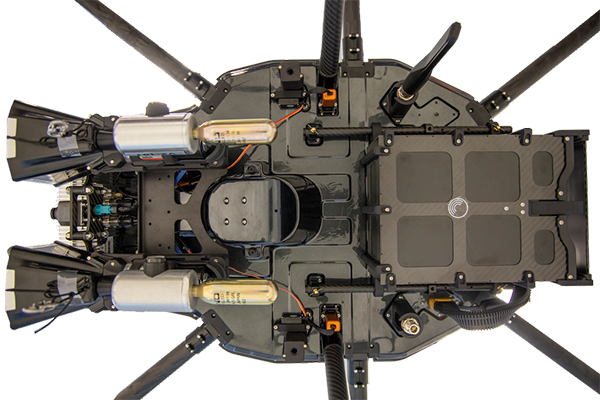
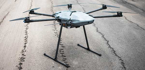
DroneHunter F700 is a radar-based autonomous interceptor drone for tracking and stopping dangerous drones
Fortem Technologies Inc. is now shipping its artificial intelligence (AI)-enabled F700 DroneHunter. The F700 is a safe, effective deterrent against a rising number of careless and criminal drones, the company said.
The F700 has a flexible undercarriage that offers interchangeable counter measures for single, multiple or swarm-based threats. Its new lightweight carbon-fiber frame enables greater athleticism and speed.
The F700 can carry multiple types of anti-drone countermeasures and deploy them in real-time, based on the dynamic threat detected miles beyond the protected area. The undercarriage features pogo pins and payload snaps integrated with AI-enabled firing and flight software.
Underside of the DroneHunter F700. (Photo: Fortem Technologies)Photo:
The F700 offers significant payload capacity to handle situations over civilians where zero collateral damage is required. AI decisions are now made in real-time to select the appropriate effectors for the detected threat. Complex algorithms for flying in urban areas are now supported. Heavier drones are tethered or parachuted with controlled descent into predetermined safe zones.
The F700 is equipped with ground- and airborne-networked radar and corresponding optics, giving users total situational awareness and autonomous precision. F700 is custom designed and manufactured in the United States.
“We have advanced the DroneHunter F700 so that it can deliver any ordinance necessary to stop drones and to protect stadiums, refineries, campuses and entire metro regions,” said Fortem Technologies CEO, Timothy Bean.
Fortem is developing several DroneHunter mitigation types, including directed energy.
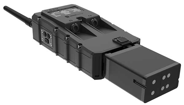
DroneShield Ltd. has released a body-worn drone detection product, RfPatrol. Weighing under 1 kilogram, the mobile unit is expected to be of significant interest to a range of DroneShield’s customer base globally, across military, law enforcement, security and VIP markets.
DroneShield made the announcement at AUVSI Exponential 2019, being held this week in Chicago.
RfPatrol is a passive (non-emitting) product, which substantially broadens the range of customers to whom the product is lawfully available. It was developed in response to customer interest.
Already, a small quantity of the RfPatrol units has been ordered by a western country’s defense department, for evaluation with a potential larger order in the future.
“We are excited to launch RfPatrol,” said DroneShield CEO Oleg Vornik. “Due to its miniaturized/body-worn nature, substantially larger customer universe due to its non-emitting nature, and a relatively lower price point compared to fixed-site products, we expect it to have substantial appeal. In addition to being able to be used as a stand-alone, it is a perfect companion to our DroneGun product.”
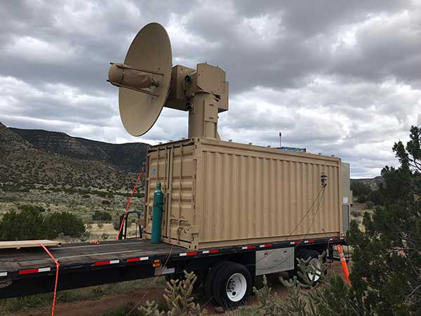
KuRFS radars address urgent operational need against drone threats.
The U.S. Army awarded Raytheon Company a $191 million contract for Ku-band radio frequency radars. KuRFS, an advanced electronically scanned array system, fills an immediate U.S. Army operational need for a counter-unmanned aerial vehicle radar, Raytheon said.
Already deployed, KuRFS delivers precision fire control as well as “sense and warn” capability for multiple missions including detection of swarming UAS threats, as well as rocket, artillery and mortar threats.
Raytheon’s KuRFS radar. (Photo: Raytheon)
“Seeing threats — like swarming drones — as soon as possible on the battlefield is essential to protecting critical assets and saving soldiers’ lives,” said Andrew Hajek, senior director of tactical radars at Raytheon Integrated Defense Systems. “KuRFS makes this possible by delivering a unique combination 360-degree situational awareness, precision and mobility.”
KuRFS enables defense against multiple threat types through integration with the Land-Based Phalanx Weapon System, 50-caliber guns and 30-mm cannons. The radar also supports high-energy laser and the Coyote weapon system in both a ground-mounted or vehicle-mounted configuration, Raytheon said.
Raytheon’ KuRFS is able to quickly address the urgent needs of the army through a model of rapid-turn development and deployment, the company added. This reduces time to fielding, while providing enhanced flexibility to adapt to a quickly-changing threat environment in the drone space.
Special section, October 2018 GPS World. Cover photo: PrecisionHawk
If you blink, you might miss something! The examples here represent only a fraction of this booming field, but they show how diverse drone use has become. Interspersed among them, this article offers further insights on technology integration, the regulatory outlook and the economic future of this fast-moving industry.
By Tony Murfin, Contributing Editor, UAV & Professional OEM
Capturing where the drone industry has been this year and where it is headed in 2019 resembles trying to describe a Florida thunderstorm: how can there be so much rain so quickly, how long will it last, and what will the landscape look like afterwards? (I’m writing this during just such a deluge near Venice on the Gulf Coast.)
The UAV/UAS industry has grown at such an amazing rate, it’s almost impossible to count or describe all the applications that have become normal practice, not to mention the number of companies involved in either making drone platforms or supplying drone integrators with sensors: GNSS, inertial, lidar, cameras photographic, thermal, infrared, video and more.
From accident reporting to crop monitoring to infrastructure inspections, drones are, so to speak, on the rise. This year we have seen substantial increases in investments by equipment suppliers, continuing funding for military businesses, prototype systems for remotely identifying and even taking down drones, and vastly expanded use in mapping and survey.
As precision guidance, autonomous operations, high-definition geocoded images and high-volume data processing all improve, drone usage will continue to increase. OEM receiver manufacturers, sensor suppliers and data-handling companies play key roles in development, and stand to profit thereby.
The Delair Septentrio UX11 mapping UAV. (Image: Septentrio)
In particular, use of drones is growing in land management, construction, mining and farming. An open-pit mine operation can be supported through detailed drone inspection producing high-resolution images. Processed images and data enable keeping tabs on inventory, site changes over time, identifying best areas for further extraction, and monitoring and managing vehicle movement. These tasks required huge amounts of time in the past. Drone overflight and processing tools condense all the effort as well as producing enhanced results to enable faster and clearer decision-making.
Surveillance and reconnaissance are probably the biggest military drone applications. Carrying payloads that include color video cameras and infrared night vision cameras, more than 19,000 drones are now in the arsenal of the U.S. Army, Air Force, Marines and Special Ops, and more have gone to other nations’ militaries. Some fly at relatively low altitude, with limited range and powered by a single quiet electric motor; these drones have become essential in gathering forward-situation intelligence.
The following examples represent only a small part of the industry. I selected them here to show how diverse drone use has become. Interspersed among them, I’ll offer further observations on technology integration, the regulatory outlook and the economic future of this fast-moving industry. If you blink, you might miss something!
Accident Investigations
In the past, when police arrived at a serious traffic accident, investigators had to use tape measures and roller wheels to construct an accurate physical record of the incident. More recently, police have used laser measuring tools but this still entails time-consuming procedures and produces traffic back-ups. Now police departments have started to collect highly accurate aerial images of traffic incidents using drones, and it’s proving quicker and more efficient.
UAVs collect photos and videos, and software then stitches multiple high-resolution images together into a 2D or 3D map. With geolocation annotation provided by the drone, investigators can then take measurements directly from visual accident records.
Previously, an investigation could take up to three hours gathering information manually, but with a drone overflying and documenting an accident this might be reduced to around 45 minutes. This clearly saves time and money for the police as well as drivers who suffer shorter traffic delays. With an investment of about $15,000 in drone hardware and training, payback can happen pretty quickly.
Overall UAV Market Growth
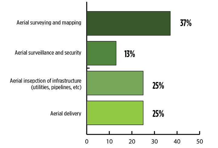
What is the killer app for drones? What professional UAV market sector will most powerfully drive adoption and influence new regulations for unmanned aerial vehicles? (Source: GPS World 2018 State of the GNSS Industry survey)
The drone logistics and transportation market was estimated to be valued at US $11.20 billion in 2022 and is projected to reach $29.06 billion by 2027, at a combined annual growth rate (CAGR) of 21.01%, according to India-based MarketsAndMarkets Research, in its May 2018 report.
The logistics and transportation market was defined to include warehousing, shipping, infrastructure, software, military, freight, and even passenger and ambulance drones. “The increasing use of unmanned aerial vehicles in civil and commercial applications for faster delivery of goods is one of the most significant factors expected to drive the growth of the drone logistics market,” stated the report.
The shipping segment is indeed projected to grow at the highest CAGR, as drones will see increasing use to transport a range of products from small packages to medical supplies and food. Venture capitalist investment in this market has been substantial as well as significant commitments by companies such as Amazon, Google, and Walmart in research and development to commercialize drone delivery services.
Couple that with another report from the same company report on the drone analytics market, valued at $1.17 billion in 2016 and projected to reach $5.41 billion by 2022, at a CAGR of 28.11% from 2017 to 2022. The drone analytics market was considered to encompass agriculture and forestry, construction, insurance, mining, utilities, telecommunications, oil and gas, and scientific research.
Both reports note that “The imposition of restrictions by various government agencies on the use of UAVs in civil and commercial applications is one of the major challenges faced by the drone logistics and transportation market.”
In February of this year, MarketsandMarkets estimated that the overall UAV market was valued at $18.14 billion in 2017 and projected to reach $52.3 billion by 2025, at a CAGR of 14.15%.
Agriculture
Results of a survey of 269 farmers by Munich Reinsurance America indicate that three quarters of all farmers in the U.S.— from those with less than 100 acres to those with more than 5,000 — have either begun to use drones for precision agriculture, and monitoring crops, livestock and soil conditions, or are thinking about using drones. Roughly half of these farmers contract out the work to drone service suppliers and most use drones either daily or more than once a week.
Sensor Integration
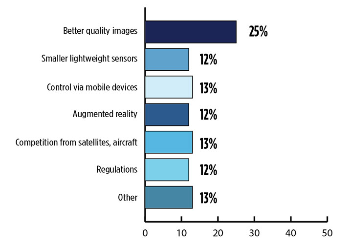
What is the biggest challenge for the UAV industry? (Source: GPS World 2018 State of the GNSS Industry survey)
As the size, weight and power (SWAP) and the accuracy of sensors continue to improve, drone use will continue increasing steadily. OEM receiver manufacturers, sensor suppliers and data-handling companies play key roles in this vital and ongoing development, and stand to profit thereby.
Making it all work is a combination of sensor payloads gathering inertial and GNSS location, stills and video, lidar, thermal and hyperspectral data; the secret sauce lies in how the data is processed and presented to users. All these areas show significant growth. The following are only a few key examples.
Lidar. Light detection and ranging (lidar) detects and measure the distance of an object or surface from an optical source, in this case a hovering or cruising UAV. GPS and inertial provide geo–referencing per each scan point.
Lidar has seen increasing application in surveying and engineering, GIS mapping, accident scene reconstruction, topographic and coastline mapping, digital elevation model and digital surface model generation, mining and quarries, gas and oil pipelines, railroads and other infrastructure. As hardware costs decline, software begins to play more and more of a major role, becoming a larger part of the solution in every way.
The M200 Snoopy series lidar package from LidarUSA is designed specifically for integration aboard the DJI M200 UAV. The laser scanning has a 100-meter maximum range, yielding 4-5 cm accuracy. It carries a tactical grade L1/L2 GPS/IMU unit and weighs 1.63 kg.
Inertial Miniaturization. UAVs are driving even further size-downs of other navigation sensors as well.
As just one example, the miniature μIMU from Inertial Sense incorporates a magnetometer, barometric pressure sensor, and L1 GPS (GNSS) receiver. Angular rate, linear acceleration, magnetic field, barometric altitude, and GPS location outputs are at 1 KHz with UTC time synchronization.
ADS-B.Aerobits in Poland has developed a high-speed, miniaturized (23.0 x 18.0 x 2.5mm & weighing 2 grams) Automatic Dependent Surveillance-Broadcast (ADS-B) module which provides detect-and-avoid for small UAVs. The module accepts external GNSS position inputs and has high speed on-chip processing which enables processing of thousands of ADS-B signals/second from other aircraft/drones. Aerobits claims a reception range of over 200 miles due to a high-sensitivity RF front-end. With FAA-mandated equipage coming for aircraft in 2020, this potentially offers a detect-and-avoid option for even small drones.
Regulatory Outlook
The Association for Unmanned Vehicle Systems International has been an industry voice for more than 40 years. AUVSI president Brian Wynne recently told Congress what needs to be done to fully integrate UAS into the National Airspace System — a critical step in further drone development and growth.
Initial regulations governing civil and commercial UAS operations are now in place. The FAA’s small UAS rule, known as Part 107, established a flexible, risk-based approach to regulating UAS and reduced many barriers to low-risk civil and commercial UAS operations. Since its enactment in 2016, however, demand for commercial UAS has exploded.
“As of March 2018,” Wynne stated, “more than 150,000 platforms have been registered for commercial use. The FAA expects more than 450,000 UAS to be flying for commercial purposes over the next five years.” That’s three times as many as today!
Waivers to Part 107 permit their holders to operate at night, as well as in certain restricted airspaces, beyond line of sight and over people. More than 1,700 operators across the U.S. have received these waivers.
Continued adoption of unmanned flight will require an expanded regulatory framework that extends the waiver provisions much more widely. There are many challenges to this, particularly security concerns. A key step will be “implementing a remote ID system that identifies any UAS flying in the airspace, in real time.” according to Wynne.
The FAA reauthorization bill recently passed by the House of Representatives calls for rulemaking concerning carriage of property, a necessary step for allowing UAS package deliveries — the next big thing.
Military UAV Business Strong
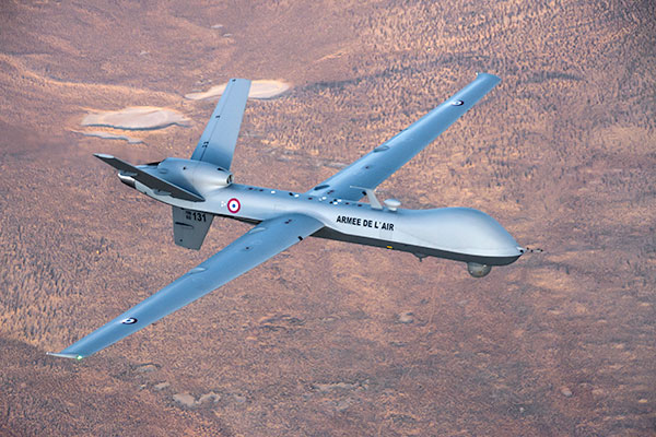
French MQ-9 Reaper. (Photo: DoD press release/UAS Vision)
Military business remains a major source of revenue for the UAV/UAS industry, as demonstrated by the recent award of several contracts to various drone suppliers.
U.S. Naval Air Systems Command recently awarded Insitu a ~$54 million fixed-price contract for four production RQ-21A Blackjack unmanned aircraft systems and eight attrition air vehicles: seven for the Marine Corps and one for the government of Poland. The contract includes ground control stations, launch and recovery equipment, shipboard equipment kits as well as systems engineering and program management support.
U.S. Army Contracting Command recently awarded General Atomics Aeronautical System Inc. (GA-ASI) a Grey Eagle engineering support contract worth ~$11m. Work will be undertaken at the GA-ASI facilities in Poway, CA and will run through to Sept 30, 2019.
GA-ASI has also just won an FMS (Foreign Military Sales) contract worth $123 million for MQ-9 Reaper systems for France – deliveries are expected to be completed by May 2020. An FMS contract is normally how a foreign government procures U.S. government military equipment. The foreign government contracts with a U.S. agency, and the U.S. agency awards a back-to-back contract to the U.S. supplier. In this case, the U.S. contracting authority is the Air Force Life Cycle Management Center at Wright-Patterson Air Force Base.
The U.S. Missile Defense Agency has awarded General Atomics Electromagnetic Systems (GA-EMS), San Diego, California, a contract worth up to ~$134 million to develop, integrate, and flight test an advanced sensor into the MQ-9 UAV. The work will be performed in San Diego, California from August 2018 through October 2021 with realistic flight testing scenarios taking place both within the U.S. and elsewhere.
At the end of August, Boeing won the contest for the U.S. Navy’s unmanned refueling tanker with an $805 million contract award. The award covers the development and manufacturing of an initial four air vehicles. The future MQ-25 Stingray will be the first UAV to operate from U.S. aircraft carriers to refuel and extend the range of several combat aircraft.
L3 Technologies has won a U.S. Army $454M contract to build, deliver and support an electro-optical infrared laser designator for the RQ-7Bv2 tactical UAS. The drone mounted payload will help the Army manage battlespace situational awareness, increase UAS survivability and obtain imagery for target/threat detection.
Counter-UAS Systems
DroneShield out of Australia markets a drone detection and mitigation system, known for its DroneGun, a point-and-shoot device able to disrupt multiple RF frequency bands simultaneously (433MHz, 915MHz, 2.4GHz & 5.8GHz), taking out the communication link to a drone operator — and also GNSS signals when so equipped — up to 1km away.
The full DroneSentry detection system integrates a suite of sensors and countermeasures including radar, optical, RF listening, acoustic, thermal and an RF countermeasure transmitter with greater power/range than the portable DroneGun.
Survey and Mapping
SenseFly recently completed work on a three-year construction project in Northern Ireland to build the new A6 highway. A senseFly eBee Plus drone provided detailed aerial coverage and minimize interruptions with road traffic and ongoing quarry operations.
Adopting an integrated aerial approach enabled the construction contractor to quickly obtain detailed, accurate, professional-grade data, and has helped save time and resources. Reducing the time required in the field and proximity to dangerous quarry sites optimized the mapping task
High-Precision Survey Drone. The TRIUMPH-F1 UAV is built around the JAVAD GNSS TRIUMPH-1M receiver, the company’s high-precision geodetic GNSS receiver with 864 channels to track all current and future GNSS signals.
When used on the ground, the TRIUMPH-F1 can function as a TRIUMPH-1M base or rover. The four motor arms (for eight motors) are detachable. Four screw inserts in the bottom to attach the TRIUMPH-F1 to a pole mount for field use.
The TRIUMPH-F1 features user-friendly mission programming. The four lithium polymer batteries that power the eight propeller motors, arranged in a stacked quad formation.
The TRIUMPH-F1 also has two micro-SD slots for image storage, a SIM card slot, a USB connector for uploading flight plans and downloading collected images, and indicators for satellite tracking and communications. Other indicators are dedicated to flight status and gyro.
Vertical Landing.WingtraOne’s vertical landing technology enables touchdown in confined areas as small as 2 m x 2 m like boats or forest lanes. Combined with a flight range of up to 50 km, this makes large-coverage mapping missions feasible
The vertical-take-off-and landing (VTOL) drone WingtraOne is designed to safeguard its valuable sensors and eliminate wear and tear of the equipment. Instead of broken wings or damaged cameras from belly landings and parachute touchdowns, the WingtraOne lands gently. During the vertical descent, laser sensor data enables the WingtraOne to sense the ground and land safely even on rocky or hilly hilly terrain.
In case of a changing landing environment like a drifting boat or recently parked cars, the landing spot can be adjusted easily.
The WingtraOne works truly autonomously during its entire mission, including take-off and landing. Instead of catapult or hand launches that can cause injuries or damage equipment, the WingtraOne takes off vertically without any human interaction.
Shipping and Logistics
Matternet, based in Switzerland, is testing deliveries using drones under a 3-year program run by the North Carolina Department of Transportation. The NC program is one of 10 authorized by the FAA to evaluate the commercial use of drones.
The objective is to transport small items like blood samples, but initially vials of water will take the ride from a medical office building before landing on a hospital roof. In March, the company was authorized to operate drones over populated areas in Switzerland, carrying samples to hospitals in Lugano.
Items can be securely deposited into the drone station for pick up or retrieved following delivery. A smartphone application is used to authorize pick up and delivery. The item is then scanned for pick up, the station automatically installs the item into the drone for transport, the drone then departs for the assigned destination and on arrival, scanning is required to retrieve the delivered item at the other end.
Conclusion
These examples just skim the surface of an exploding industry which just keeps on keeping on, constantly developing new solutions and applications. High-altitude pseudo satellite drones, drone delivery of goods within minutes of placing an internet order, automated drone facility inspections, power via wireless to keep drones airborne, parachute safety systems for drones….the list goes on and on.
Clearly the UAV/UAS industry has only begun its journey. There are many unexpected places we can look forward to it visiting in coming months and years.