Tag: crop health

  • Precision farming market to reach $12 billion by 2025

    Precision farming market to reach $12 billion by 2025

    Photo: USDA
    Photo: USDA

    The precision farming market is set to grow from its current market value of more than $4 billion to more than $12 billion by 2025, as reported in the latest study by Global Market Insights, Inc.

    The market growth is attributed to the rising adoption of smart agricultural practices to increase productivity. The use of Big Data along with information and communication technologies will provide farmers with more accurate insights into the existing crop conditions.

    Another factor contributing to the precision farming market growth is the popularity of drones and IoT for greater production capabilities and analytics. The IoT plays a substantial role in increasing productivity and providing insights about the recent trends of crops. The technology provides an interconnected and multidimensional view of farming activities and offers actionable insights about the environment.

    The government agencies worldwide are making efforts to spur innovations in the agriculture sector. For instance, in 2017, the Dutch government invested USD 1.5 million in the agriculture sector to allow the use of satellite technology to collect crop data for precision farming.

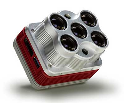
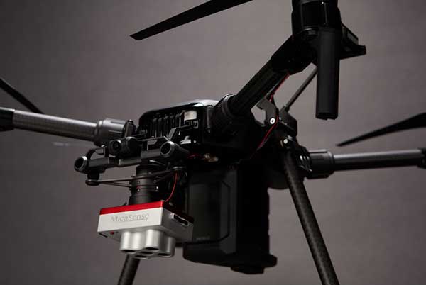
    In the component market, the hardware segment is expected to hold a major market share of over 70% in 2025 due to the rising usage of several hardware devices such as drones, sensors, GPS systems, and smartphones for capturing aerial data. In precision farming, these devices enable farmers and researchers to monitor and optimize their crops and assist in conserving resources such as soil and water in a better manner.

    In the precision farming services market, the managed services segment is expected to exhibit a growth rate of over 27% from 2019 to 2025. The market growth is attributed to the rising applications of IoT and cloud computing in precision farming solutions.

    The agriculture decision support systems are being increasingly hosted on cloud platforms to take advantage of the IoT through internet-connected devices. For enabling improved security and availability, the demand for managed services has to increase to efficiently handle the complexity of running hardware and maintaining different types of middleware.

    Geomapping technologies are expected to hold a share of over 20% of the precision farming market in 2025. The technology proves to be immensely beneficial in agriculture as it offers a cost-effective alternative for localized and wide-scale monitoring of the crop output.

    With the evolution of the technology, 3D geo-mapping techniques have emerged in the market that are particularly useful for the timely detection of existing inefficiencies in the fields, allowing farmers to take immediate corrective measures.

    The irrigation management application segment is projected to grow at a CAGR of over 15% between 2019 and 2025. Using precision farming technologies, the site-specific management of irrigation activities can significantly improve the overall water management.

    Farmers can monitor and control their irrigation pivots from any location using precision irrigation solutions. These solutions enable accurate and uniform water delivery to crops throughout their lifecycle.

    The Asia Pacific precision farming market will witness a growth rate of over 20% during the forecast period. The factors augmenting the market growth are increasing the awareness about the precision farming technologies and several initiatives taken by the government to improve sustainable agriculture.

    For instance, in June 2017, the state government of Haryana in India adopted climate-smart agricultural practices to transform the agricultural systems. This also enabled the regulatory bodies to achieve three objectives such as adapting to climate changes, achieving agricultural productivity, and reducing greenhouse gas emissions.

    The rising adoption of drones and UAVs for capturing crop-related data is also leading to precision farming market growth. For example, in March 2019, the Agriculture Ministry of Japan promoted the use of drones in the agriculture sector. This will help in increasing productivity and improving crop health by closely monitoring the crop condition.

    The companies in the precision farming market are entering into strategic partnerships and acquiring companies to gain more market share. For instance, in September 2018, Topcon Agriculture entered into a licensing agreement with Raven Industries. Under the agreement, Topcon Agriculture’s Slingshot Application Programming Interface (API) was used in Raven’s software platforms.

    The software-to-software interface help users to share data between software systems. Some companies are concentrating on new product developments to enhance the capabilities of their existing offerings and to expand their product line up.

  • MicaSense offers Altum 3-in-1 sensor for ag drone mapping

    MicaSense offers Altum 3-in-1 sensor for ag drone mapping

    The Altum is a 3-in-1 sensor that combines thermal, high-resolution and multispectral imaging capabilities in one sensor. (Photo: MicaSense)
    The Altum is a 3-in-1 sensor that combines thermal, high-resolution and multispectral imaging capabilities. (Photo: MicaSense)

    The Altum sensor, offered by MicaSense, is designed for professional-grade agricultural drone mapping by enterprise and academic researchers. The Altum captures synchronized multispectral and thermal imagery, enabling aligned outputs for advanced analytics.

    Altum’s multispectral imagers are the highest resolution integrated multispectral solution available for drones, allowing for detailed RGB outputs and advanced crop classifications.

    Whereas before they had to fly multiple flights with multiple sensors, researchers, growers and service providers can now capture data for plant health, water stress mapping, phenotyping and more in one flight, with one sensor.

    The Microsense RedEdge-MX sensor aboard DJI's M210 RTK drone. (Photo: MicaSense)
    The Microsense RedEdge-MX sensor aboard DJI’s M210 RTK drone. (Photo: MicaSense)

    “The Altum design resulted from experience developing advanced analytics and understanding needs for advanced research,” said Justin McAllister, CTO and co-founder of MicaSense. “We realized the market is limited by time and cost constraints of owning multiple sensors and flying multiple passes over the same field. The goal of Altum is to simplify the workflow, and with synchronized capture, to provide results that can be correlated and quantified more easily.”

    Altum includes MicaSense’s standard five-band configuration of multispectral bands (red, green, blue, near-infrared and red-edge) and an integrated Lepton radiometric thermal longwave infrared sensor from FLIR Systems, providing temperature measurement for every pixel of the scene for additional crop data and optimization.

    https://youtu.be/Kdim4uol7S4

    Expandable high-capacity USB 3.0 storage allows users to fly longer and cover more area without landing to swap storage. In addition, advancements in image capture rate enables faster flight speeds.

    Users can process Altum data with industry standard software like Agisoft and Pix4Dmapper to generate an aligned, radiometrically calibrated six band (R, G, B, RE, NIR, T) geotiff, or access the raw data from Altum to process data themselves.

    Included with Altum is DLS 2, the patent-pending next generation of the MicaSense Downwelling Light Sensor (DLS). DLS 2 allows for a more streamlined integration as it combines both the DLS and GPS into one product. In addition, through proprietary MicaSense technology, the DLS 2 will offer significantly better calibration for changing light conditions and better measurements over time.

    Integrated solutions

    Altum’s multiple interface options and open API gives users the ability to utilize Altum on a variety of platforms. In addition to the DJI SkyPort integration, Altum is integrated with drone offerings from the following companies (with more to come):

    • North America: Drone Nerds (U.S.), BirdsEyeView Aerobotics (U.S)., OmniView Tech (Canada), Sky Flight Robotics (U.S.), Blue Skies Drone Rental (U.S.)
    • Europe: 3D Target (IT), Globe Flight (DE), C-Astral (SI), Droneparts.de (DE), Ecobotix (DK), NaviGate (PL), Quantum Systems (DE)
    • Asia: Cybernetech (Japan), Shenzhen Qianhai Yaqi Technology (China)

    DJI Payload SDK Program: Altum and RedEdge-MX for DJI M200 Series

    Through DJI SkyPort, MicaSense is able to provide seamless integration of its specialized sensors with DJI’s powerful line of enterprise drones, resulting in the MicaSense Altum and RedEdge-MX solutions. This provides users a high-quality drone and sensor combination they can rely on to capture quality data every time – with virtually no set-up time.

    The DJI SkyPort integration for Altum and RedEdge-MX features plug-and-play integration for Altum and RedEdge-MX right out of the box, including power and quick connect/disconnect, and enhanced light calibration with MicaSense DLS 2.

    “Solutions like the MicaSense Altum and RedEdge-MX demonstrate the value of integrating specialized industrial payloads to DJI’s powerful drone platforms,” said Jan Gasparic, head of Enterprise Partnerships at DJI. “By collaborating with solution providers, we are expanding the benefits of drone technology to more and more industries. In the case of agriculture, a specialized suite of sensors and more advanced level of analytics can truly bring tangible value to business workflows and decision making today.”

    The Altum and SkyPort enabled RedEdge-MX and Altum are available today through the MicaSense website.

  • Farmers on Climate FieldView can access satellite imagery

    Airbus Defence and Space and The Climate Corporation, a subsidiary of Bayer, have announced a global agreement to deliver frequently updated satellite imagery from Airbus to farmers through Climate FieldView, a digital agriculture platform.

    Farmers who use Climate FieldView can access high-resolution data of their fields from the Airbus SPOT 6, SPOT 7 and Pléiades satellites throughout the growing season. This gives FieldView customers the ability to more precisely monitor crop health and performance, helping them take action in the field before yield is impacted at the end of the season.

    They will also be able to visualize this satellite imagery alongside other data layers in their FieldView account, including planting and yield data, to unlock new insights about crop health.

    The large swath and coverage capabilities of the SPOT satellites enable mapping at a national level down to individual farmland parcels, while the Pléiades satellites can be used to pinpoint details in specific areas, thanks to its combination of sub-meter resolution and multispectral bands.

    The complementarity between SPOT and Pléiades resolutions, swaths and revisits is crucial for effectively monitoring crops more precisely and helps enable more-informed decision-making.

    “We are very pleased to be working with The Climate Corporation to enhance FieldView by providing them with access to updated, cloud-free images within the time frame required to efficiently monitor crops at each key growth stage,” said François Lombard, head of Intelligence Business at Airbus Defence and Space.

    “High-quality satellite imagery integrated into a farmer’s Climate FieldView account can bring in more consistent and invaluable field-level insights,” said Steven Ward, Senior Director of Geospatial and Weather Sciences at The Climate Corporation. “This partnership with Airbus supports Climate’s commitment to deliver the most robust imagery ecosystem on the farm, helping farmers make important decisions tailored precisely to their individual fields.”

    The Climate Corporation’s mission is to help the world’s farmers sustainably increase their productivity through the use of digital tools. First launched in the United States in 2015, the company’s Climate FieldView platform gives farmers a deeper understanding of their fields so they can make more informed operating decisions to optimize yields, maximize efficiency and reduce risk.

    FieldView is currently on more than 60 million paid acres across the United States, Canada, Brazil and Europe.