Ness Czech will supply the Czech Railway Administration with a Digital Technical Railway Map (DTRM) with help from Hexagon’s Safety, Infrastructure and Geospatial division. The DTRM project has been underway since September 2022 and will be implemented by 2025.
DTRM is a railway-specific geographic information system (GIS), that provides access to transport and technical infrastructure information to better prepare investments and repair work. The basis of the DTRM project is the Technical Map Information System (ISTEM) developed by Ness and Hexagon.
The project includes digitization and consolidation of all available Czech Railway Administration data, covering more than 9,200 km of tracks, 27,000 km of technical infrastructure and an area of 21,000 ha. The delivery also includes three data centers.
The project is a legislative obligation of the Czech Railway Administration as the state is developing a national map, which will be fully operational by 2024. The Digital Technical Map of the Czech Republic is being built across the country by connecting regional digital maps, maps from the Railway Administration and maps provided by the Directorate of Roads and Highways. The connection is provided by the Czech Land Surveying and Cadastral Office.
Schematic of the GNSS interference detection and analysis system GIDAS. (Image: OHB Digital Solutions)
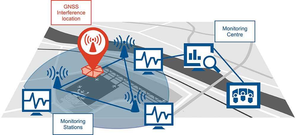
In September 2020, the first GIDAS monitoring stations were installed at the Czech airport in Brno.
GIDAS — GNSS Interference Detection and Analysis System — enables continuous 24/7 monitoring of the GNSS frequency bands within a defined region to automatically detect, classify and localize intentional interference from jamming and spoofing.
GIDAS can raise the alarm in real time, identify the type of interference, and then pinpoint the location of these dangerous portable devices causing the interference so the authorities can take immediate remedial action. It considerably improves safe and robust operation of GNSS receivers, terminals and applications.
GIDAS was developed by OHB Digital Solutions and Joanneum University of Applied Sciences through ESA’s Navigation Innovation and Support Programme (NAVISP).
The system works autonomously and is designed to be easily deployed. It is scalable and flexible; it can be used as a standalone monitoring station or upgraded to a network of stations.
Recent GNSS interference attacks include:
shutdown of navigation equipment at Newark airport
GNSS attacks of North Korea against South Korea
117 incidents within one day at Kaohsiung airport in Taiwan
a U.S. military drone forced to land
a 65-meter yacht drifting off course during field trials
failure of emergency pagers, traffic management systems and ATMs in San Diego caused by U.S. Navy jamming.
“In recent years, GNSS applications have increasingly become the target of intentional interference attacks, since GNSS is widely used in safety and value-critical applications,” said Andreas Lesch, CEO of OHB Digital Solutions. “GIDAS detects, classifies and localizes GNSS interference signals and thus reduces the already existing threat of receiving worse accuracies or even denial of service.”
The GIDAS system user interface helps to pinpoint interference. (Image: OHB Digital Solutions)
GIDAS monitors the GNSS L1/E1 frequency band and reliably detects and classifies intentional and unintentional interference sources using sophisticated algorithms. GIDAS consists of a high performance data processing unit including antenna and RF front-end, and a sophisticated software solution.
GIDAS is able not only to monitor GNSS-based position, velocity and time solutions, it monitors the received signal and baseband processing.
The system is composed of the following software modules:
Software-defined GNSS radio
Position, baseband and C/N0 monitoring
Jammer and spoofing parameter estimation
Localization capabilities through synchronization of several GIDAS systems
Graphical user interface
Initial GIDAS reports show an average of seven GNSS interference events per day. GIDAS was able to successfully classify the signal type in 96% of jamming cases that have occurred.
The European GNSS Agency (GSA) in Prague, Czech Republic, has brought financial benefits to the country over the past five years — 1 billion crowns, according to a report by Czech Radio. The GSA is the only European-wide government agency sited in the country.
The GSA moved from Brussels, Belgium, to Prague in 2012.
The Prague agency – employing around 200 – deals with the programs that will turn the satellite network and signals into applications can be used by companies and the public at large.
One of the main benefits for the Czech Republic of having the headquarters in Prague is that the country is now on the doorstep for many Czech companies. The number of Czech firms are now receiving research and development funds linked to navigation services has increased ten-fold, with 44 Czech companies directly active in the navigation sector.
The Czech government signed an agrement January 27 with the European GNSS Agency (GSA) for Prague to host the headquarters of the Galileo system. The signing took place during the Galileo Application Congress Prague 2012.
Paving the way for the Agency’s presence in the Czech Republic, the host agreement was jointly signed by Pavel Dobeš, minister of Transport, and Carlo des Dorides, executive director of the GSA, in the presence of Petr Nečas, prime minister of the Czech Republic and Antonio Tajani, vice president of the European Commission responsible for industry and entrepreneurship. The accord will see the GSA moved to Prague later this year.
The Galileo Applications Congress in Prague drew experts from around Europe and around the world to discuss Galileo and possible services. representatives of the European Union, the European Space Agency (ESA) and the GSA discussed their future roles in Europe's GNSS programmes, Galileo and EGNOS. The event also took place against a backdrop of key changes in how Europe's flagship GNSS programmes are governed.
"This is a good moment to take stock of where we are and where we are going with Galileo," said GSA Executive Director Carlo Des Dorides. "The focus is on the future, with an expanded mission for our Agency. What we can say now is that the future is bright; the market for new GNSS technologies and services, many of which you will hear about during this congress, will continue to grow, in spite of the current difficult economic conditions."
Under the current European Commission proposal for a new GNSS governance arrangement, the GSA would be charged with the commercialisation and exploitation of Galileo and EGNOS services, including the operations of the Galileo security monitoring centers to be deployed in the UK and France. The Commission itself would provide the policy framework and political support, while ESA would provide the engineering competence. And while some details still need to be clarified, including how the interfaces between these three bodies would operate, most opinions seem to be moving quickly into line with the proposal.
ESA Director General Jean-Jacques Dordain said the measure of Galileo's success will not be in the number of satellites placed in orbit but in the quality of its services. "The very existence of the GSA as the service provider is a key to this success," he said. "Working to support the GSA, therefore, will also be ESA's objective, and we are committed to seeing this happen."