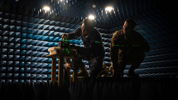
Personnel from the Australian Joint Precision Navigation and Timing Directorate, Joint Capabilities Group and Joint Navigation Warfare Center align GPS test equipment in the JNWC anechoic chamber at Kirtland Air Force Base, N.M., in preparation for a GPS resilience test April 15, 2024. This combined effort not only enhances GPS navigation resilience but also exemplifies the power of international cooperation in addressing security threats. As the world faces evolving challenges, partnerships like these remain essential for maintaining an edge in contested environments. (U.S. Air Force photo by Senior Airman Spencer Kanar)
The Australian Department of Defense has collaborated with the Joint Navigation Warfare Center (JNWC) to enhance the resilience of GPS devices in contested environments. The JNWC’s mission is to ensure positioning, navigation and timing (PNT) superiority for the Department of Defense and its partners. This joint effort aimed to test the performance of GPS devices under simulated jamming conditions.
Personnel from the Australian Joint Positioning, Navigation and Timing Directorate worked with JNWC experts to evaluate the Defense Advanced GPS Receiver (DAGR), a crucial device used by U.S. and allied forces for navigation across land, sea, and air. The testing took place in an anechoic chamber designed to replicate contested and limited GPS conditions, providing insights to improve the device’s resilience.
The JNWC, recognized for its expertise in navigation warfare, created optimal conditions for this assessment. The specialized chamber allowed them to test the DAGR’s performance in a jamming environment, generating data that can inform the device’s warfighting effectiveness. The team explored solutions such as antennas that enhance jamming resilience, and the findings will be shared with coalition partners to strengthen collective space resilience.
The collaboration serves as a model for international cooperation in addressing security threats, enhancing GPS navigation and timing resilience for allied forces.
At the Joint Navigation Conference in San Diego, BAE Systems unveiled NavGuide, an assured-positioning, navigation and timing (A-PNT) device featuring M-code GPS technology. NavGuide is a field-installable replacement to the defense advanced GPS receiver (DAGR), designed for quick integration into current DAGR mounts and accessories without mission interruption.
NavGuide features a 3 in, full-color, graphical user interface for dismounted soldiers, and easily integrates with existing mounted platforms and systems. The device leverages the advanced M-code GPS signal with enhanced jamming and spoofing protection.
NavGuide is portable, versatile, and precise, and enables vehicular, handheld, sensor, and gun laying applications that enable the military to defeat adversaries in a variety of challenging threat environments.
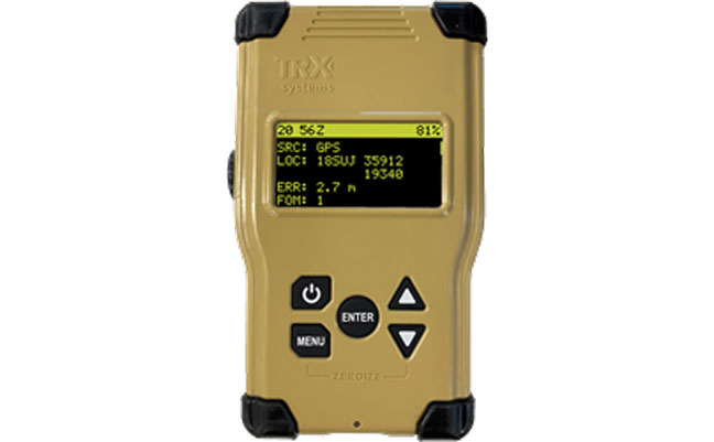
TRX Systems, developer of NEON GPS-denied location solutions, has been selected by the U.S. Army to provide a next-generation Dismounted Assured Positioning, Navigation and Timing (PNT) System (DAPS).
The TRX DAPS solution employs a lightweight soldier-worn device that enables dismounted warfighters to successfully conduct operations when operating in GPS challenged, degraded or denied environments.
Military equipment can be the subject of enemy electronic attacks, potentially resulting in a loss of location awareness that can put army missions at increased risk. The TRX DAPS solution alerts the users when their position isn’t reliable and then leverages multiple sensors and timing sources to provide the best soldier position possible within the GPS-degraded operational environment.
The solution — designed to replace the Defense Advanced GPS Receiver (DAGR) — supports both a standalone configuration and integration with the Nett Warrior ensemble. It combines inputs from small, body-worn sensors and other sources to provide assured PNT while meeting the size, weight and power (SWaP) needs of dismounted soldiers already physically burdened with heavy equipment loads.
TRX Systems has delivered GPS-denied location technology to thousands of military, public safety and security users worldwide.
“Maintaining assured PNT is paramount to the situational awareness of U.S. warfighters in the many conflict zones around the world,” said Carol Politi, president and CEO of TRX Systems. “When initial units are fielded in mid-2022, the TRX DAPS solution will deliver a balance of the highest possible level of integrated PNT capabilities with the smallest package that can be fielded for dismounted warfighters.”
SMC awards multiple rapid prototyping agreements for joint modernized GPS handheld device; four demonstrations to be held
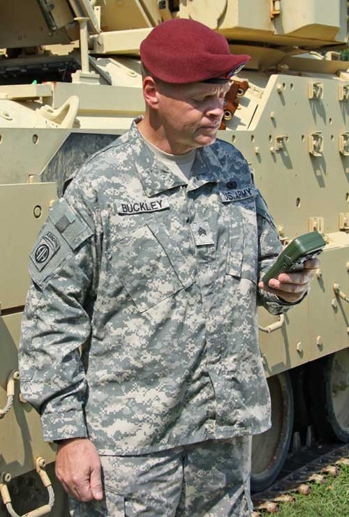
The Defense Advanced GPS Receiver (DAGR) in use in 2011. (Photo: U.S. Army)
On June 26, the United States Space Force’s Space and Missile Systems Center awarded three separate rapid prototyping agreements to Collins Aerospace, Raytheon Intelligence & Space and the Technology Advancement Group for a total of $41.1 million.
The firm-fixed price agreements are for the development of a basic working prototype of the joint modernized GPS handheld device. The contract provides the government with innovative solutions demonstrated via hardware and software prototype development.
The purpose of this rapid prototyping effort is to produce a joint modernized handheld smaller in size with low power consumption, increased military-code capability, and improved anti-jamming and anti-spoofing capabilities compared to the equipment now used by the military.
4 demonstrations coming
This is the second competitive objective under the current Phase I strategy and is the result of a down-select from five to three vendors. It builds off the first objective of Phase I, which focused on mock-ups and drawings.
These agreements provide for four demonstrations to be held with Army and Marine Corps representatives. The demonstrations give the end users an early opportunity to provide feedback and the ability to influence the final design — ultimately making for a more seamless transition to operations.
“This is the first major update to the military’s GPS handheld device in more than 15 years,” said Col. Clifford Sulham, User Products Division chief. “The advanced capabilities of this device will allow our airmen, soldiers, sailors and Marines to conduct operations in GPS-challenged environments.”
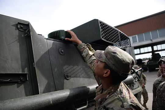
Sixty-two of the first iteration of mounted anti-jam GPS devices were equipped into light armored vehicles in Germany over the past month, with thousands more scheduled to be installed into U.S. European Command vehicles by 2028, said Army leaders in charge of location data on future battlefields.
The Mounted Assured Precision Navigation & Timing System — known as MAPS — was developed to provide trusted positioning, navigation and timing (PNT) to a platform, such as Stryker vehicles, by pairing a GPS receiver with an anti-jam antenna, said Col. Nickolas Kioutas, PNT project manager.
Read more about MAPS, along with other anti-jam systems, here. Also look for our anti-jam feature coming in the December issue of GPS World magazine.
The electronic technology comes amid the Army’s vision for 2028, to best prepare soldiers for possible warfare with near-peer competitors, who have used electronic warfare to disrupt communications vital to Western forces in recent years.
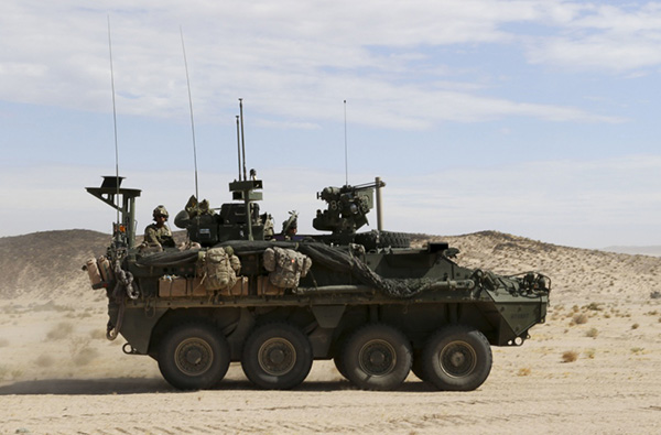
This year, more than 300 Stryker vehicles, all from the 2nd Cavalry Regiment, are expected to be fielded with MAPS technology, said Willie Nelson, the director of the Army’s Assured PNT Cross-Functional Team.
Upgraded first-generation and second-generation technology is also expected to be unveiled in the future.
The Army also plans to equip armored brigades with the technology, and put MAPS in vehicles such as the Bradley Fighting Vehicle, M1 Abrams tank, and the M109 Paladin self-propelled howitzer. After those “priority vehicles,” the Army will evaluate the mounted device in second-tier priority vehicles, Nelson said.
Soldiers from 2-2 Stryker Brigade Combat Team move out in their Stryker during their training rotation at the National Training Center on Fort Irwin, Calif., Sept. 2, 2019. (Photo: Sgt. Ryan Barwick/U.S. Army)
In the past, armored vehicles have used multiple Defense Advanced GPS receivers, known as DAGR devices.
MAPS replaces multiple DAGR devices with one “really good system,” said Kioutas. The new system uses a chip-scale atomic clock for timing, Selective Availability and Anti-Spoof Module, or SAASM, for GPS, and anti-jamming antenna to distribute PNT information.
In addition, future iterations of MAPS will include non-GPS sensors by fusing GPS with alternate navigation and timing technologies to ensure accurate PNT that soldiers can trust while operating in various threat or denied environments, according to a statement.
A single-point GPS also creates multiple practical benefits for soldiers, such as less maintenance and system key-failing, Kioutas said, adding many of his team’s decisions are based on Soldier feedback, because listening to them today helps prepare them for tomorrow.
Simply put, “MAPS continues to work whenever a GPS signal is weakened or compromised,” he said.
“This is the first technology equipping for the Assured Positioning, Navigation and Timing Cross-Functional Team, and one of the first for Army Futures Command,” Kioutas said.
Nelson noted that they’re “working in parallel with both mounted vehicles and dismounted soldier’s PNT gear.”
A soldier checks part of a Mounted Assured Precision Navigation & Timing System — known as MAPS. Sixty-two of the first iteration of mounted anti-jam GPS devices were equipped into light armored vehicles in Germany over the past month, with thousands more scheduled to be installed into U.S. European Command vehicles by 2028. (Photo: John Higgins)
Earlier this year, a requirements document for the dismounted soldier’s PNT was signed. Now, currently in the prototyping phase, the latest iteration of a dismounted GPS receiver can send secure PNT data wired or wirelessly, Kioutas said.
“A lot is happening here, a lot of good success,” Nelson said, adding, the most important thing for his team is to get the best equipment to “warfighters on the front lines and getting their feedback rolled back into the next generation.”
Nelson will host a Warrior’s Corner presentation Oct. 15 focusing on the PNT CFT’s Tactical Space Line of Effort, at the Walter E. Washington Convention center in Washington, D.C.
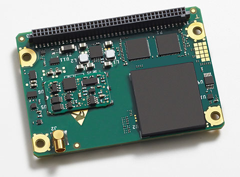
The Rockwell Collins GB-GRAM-M (pictured here) is the product of one of the MUE card development contracts, awarded by the U.S. Air Force Space and Missile Systems Center. The program is developing the next generation of GPS user equipment to include a new military signal and enhanced security architecture
GPS Source and Rockwell Collins have successfully demonstrated the ability of the Military-Code Ground-Based GPS Receiver Application Module (GB-GRAM-M) receiver card to fit within the Defense Advanced GPS Receiver (DAGR) Distributed Device (D3).
GPS Source and Rockwell Collins are the first to provide this capability for the M-code signal, which is one of the key elements in the modernization of military GPS capabilities.
The initial fit checks confirm that the Rockwell Collins GB-GRAM-M Type II receiver fits within the volume of the D3 and is able to acquire, track and navigate using C/A, Y and M-code while enclosed in the unit. Initial testing also validated backwards compatibility of the IS-GPS-153 serial port interface of the GB-GRAM-M receiver.
“These outstanding initial results confirm our confidence that the MGUE integration with the D3, when authorized to proceed, will be achieved in short order and with a very high probability of success,” said GPS Source CEO Robert Horton.
Mike Jones, vice president and general manager of Communication and Navigation Products for Rockwell Collins, added, “This demonstration paves the way for the D3 to incorporate the next-generation GPS capability that our GB-GRAM-M provides.”
GPS Source’s D3 supports new or retrofit programs integrating radio or communications equipment. It removes the burden of multiple SAASM GPS receivers or antennas. As a Selective Availability Anti-Spoofing Module GPS router, it is designed to meet the U.S. Army’s DAGR Distributed Device (D3) performance requirements, mounted into an existing DAGR vehicle mount, utilizing standard DAGR accessories.
The Rockwell Collins GB-GRAM-M is the product of one of the MUE card development contracts, awarded by the U.S. Air Force Space and Missile Systems Center. The program is developing the next generation of GPS user equipment to include a new military signal and enhanced security architecture.
PCTEL, Inc. will display its GPS, GNSS, mobile, and infrastructure communication antennas at the 2013 MILCOM Military Communications Conference. MILCOM is being held in the San Diego Convention Center, San Diego, California, November 18-20.
PCTEL Connected Solutions provides advanced military antenna designs. Its high-precision, ruggedized antennas enable reliable communications, timing, and location services in the field, while its site solutions products aid deployments of communications equipment for outdoor and indoor applications, the company said.
PCTEL’s precision GPS and GNSS antennas are used for munitions guidance, aviation, marine, tactical radio manpack, vehicle tracking, soldier, and asset tracking. Recently, PCTEL expanded its GNSS antenna line to include the GPS-LB12GL-MAG, a multiband GPS L1/2, L-Band, and GLONASS antenna. At MILCOM, PCTEL will be showcasing the GPS-L1L2-28MAG, a GPS L1/L2 antenna that has been approved for DAGR (Defense Advanced GPS Receiver) applications. Both of these antennas can be used as soldier-worn asset trackers, military vehicle trackers, and other military tracking applications.
Reliable communications are critical to any field operation. PCTEL’s ruggedized, high performance antennas have been deployed and qualified for tactical mesh networking, which enables complex field communications. PCTEL designs both SISO and MIMO antennas that cover the NATO IV band, also known as the 4.4 GHz C band. For mesh networking and many other mission critical communications systems, accurate GPS timing information is essential. PCTEL has designed the GPS-TMG-HR-26N GPS timing antenna with high out-of-band rejection for reliable communications in high-interference environments.
In addition to its high-performance antennas, PCTEL provides site solutions that enable indoor and outdoor deployments of communications systems for public safety and defense applications, including enclosure systems, coaxial cable assemblies, fiber jumpers, lightning protection, and mobile towers.
“PCTEL designs products that users can count on to help deliver wireless solutions when it matters–and no situation matters more than military field operations,” said Jeff Miller, president of PCTEL Connected Solutions. “We continue to work closely with our customers to expand our portfolio of GPS, GNSS, and communications antennas and site solutions that address emerging needs,” added Miller.
GPS Source has received an indefinite-delivery/indefinite-quantity, firm-fixed-price contract with a maximum value of $16,613,430 for the procurement of defense advanced global positioning system receiver distributed devices (D3). The Army Contracting Command, Aberdeen Proving Ground, Md., was the contracting activity (W15P7T-13-D-C116).
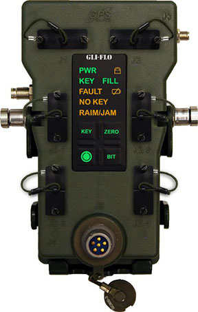
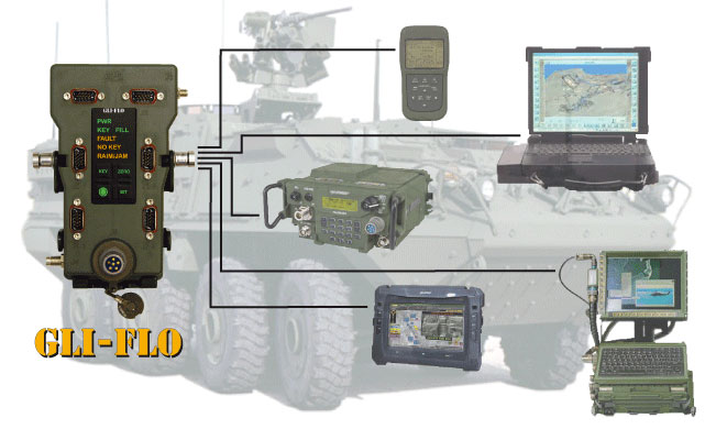
GLI-FLO was developed by the defense contract engineering firm, GPS Source. GLI-FLO is a DAGR Distributed Device (D3) that can replace the position, navigation and timing (PNT) role currently required of the DAGR or other GB-GRAM devices inside a fixed vehicle platform. Designed as a single, secure access point to multiple devices requiring PNT data on a fixed vehicle platform, it saves space, weight and power (SWaP).
“The GLI-FLO contract award is an important milestone in GPS Source’s initiative for the defense market,” said Robert Horton, CEO of GPS Source. “Getting this award was a complicated process, but it helps fulfill our vision of continual innovation in GNSS Signal Availability, especially for the warfighter. We look forward to continuing to provide manufacturing and engineering support services to the Department of Defense.”
GPS Source announced today that GLI-FLO has been granted security approval by the U.S. Air Force Global Positioning Systems Directorate. The GPS Directorate security approval provides GPS Source with the opportunity to supply military end-users and prime contractors with a DAGR Distributed Device (D3) that meets the mandate for reliability and security, GPS Source said.
GLI-FLO is a secure (ICD-GPS-153 compliant) GPS position, navigation, and timing (PNT) distribution device. One GLI-FLO has the same capability as four DAGRs operating in a platform mounted application (eight DAGRs with custom cabling). GLI-FLO serves ICD-GPS-153 PNT data simultaneously to multiple communication or weapon systems that require GPS information. It routes PNT data while secured in the bracket now used by the DAGR, utilizing standard DAGR accessory cables. When GLI-FLO is connected to one DAGR (or as alternative option, interfaces with an internal secure GPS receiver), secure PNT data can be distributed without the integration of GB-GRAM cards to multiple devices.
GLI-FLO meets the stringent requirements for reliability and security by integrating a GPS Directorate-approved SAASM receiver (Selective Availability/Anti-Spoofing Module). SAASM is the security architecture selected by the Joint Chiefs of Staff (JCS) to provide current security functions for GPS-authorized military users.
“We understand the importance of reliable GPS/PNT data for synchronizing military operations and the need to protect against jamming and/or spoofing,” said Robert Horton, CEO of GPS Source. “We further realize the importance of protecting our national assets by designing products that fully comply with all GPS Directorate security requirements. This security approval makes it possible for our GLI-FLO to be deployed by military forces without reservation.”
In addition to the SAASM compliance, other GLI-FLO features include the ability to serve ICD-GPS-153 PNT data simultaneously to multiple communications or weapon systems that require secure GPS information. It is a significant step for GPS Source toward compliance in GPS Signal Distribution (Single PNT Distribution Point). With zero impact to subscriber application software/hardware, it removes the need to rely on multiple, expensive GB-GRAMS found in military platforms.
It happens every year and it is an emotional rollercoaster. It generally starts a couple of weeks before Thanksgiving and continues until just after New Years – and it is simply heartbreaking. The letters and emails start arriving just like clockwork before the holidays and they all ask the same question – where can I buy the PHGPST or the Perfect Handheld GPS Transceiver?
As many of you know, who are faithful readers, I receive hundreds of letters and emails like this throughout the year from our warfighters and first responders, but the letters and emails over the holidays are special because they are from the wives, sisters, children, parents and grandparents of war fighters. They want nothing but the best for their loved ones. It breaks my heart to have to tell them that the PHGPST does not exist – yet.
Without a doubt, our warfighters and first responders, who put their lives on the line so that we may continue to live and thrive in a free world, where innovation and response to customer needs are hopefully met with success both emotional and fiscal, deserve nothing but the best, and that is the goal I continue to pursue on their behalf.
Dissatisfaction
Paraphrasing Walter Kaufman, “Otherworldliness or ‘belief that there is a better world’ is the child of disenchantment with this world.” To say our warfighters are disenchanted with the antiquated legacy MUE or military user equipment they are forced by policy to utilize today is an understatement. DoD’s antediluvian MUE is a joke compared to what is available in the commercial marketplace today. Studies indicate our warfighters are aware of this dichotomy and have shown their disdain in the last ten years by using commercial and civil PNT equipment in theater 40/1 over the government’s archaic MUE handheld devices. Studies further show that MUE is utilized by our warfighters only as a last resort and as a matter of necessity due to the outdated policies and technologies that continue to prevail. However, I am happy to say these anachronistic restrictions are reportedly rapidly coming to an end.
Consider that the USMC (US Marine Corps) decertified the PLGR in 2009 because “the PLGR or Precision GPS Lightweight Receiver is an obsolete GPS military receiver” [ed. PLGR was designed circa 1988] and almost all Services today use the DAGR or Defense Advanced GPS Receiver [ed. the DAGR was designed circa 2002]. The DAGR was a major capability improvement ten years ago but today is technologically obsolete and primarily used as an embedded solution only. As an embedded device the DAGR serves its purpose — providing an antiquated, unfriendly user interface to legacy government equipment. For example, rumor has it that one version of the Stryker, of which the Army has more than 4,200 in service, described as a technologically advanced combat fighting vehicle, uses nine, count them, nine individual DAGRs. Draw your own conclusions. I suspect this has more to do with the inadequacies of the DAGR vice the capabilities of the Stryker. The good news here is that my sources in the DoD tell me there will be no further DAGR purchases. Now if I were giving this as an oral presentation, I would pause here for thundering applause and a standing ovation. Can I have an Amen?
Several years ago, I penned the following: “MUE is necessary because it is the only platform that currently provides SAASM (selective availability anti-spoofing module) protection, along with a second military frequency giving the military user an advantage over his civilian counterpart.” Today none of that statement is true from a purely intrinsic or commercial point of view. There are much more capable receivers with all these capabilities and more, to include real-time centimeter-level accuracy, available on the commercial market today.
Marketplace Responds
This year the PNT (position, navigation and timing) marketplace has finally responded, and I am able to reply to warfighter family enquiries with more positive information. In just the last 18-24 months, the path to an actual PHGPST has been blazed by several major GPS manufacturers, and well-informed pundits say DOD policy changes may be in the wind as well.
The PHGPST
I had a three-hour lunch several weeks ago with the chief PNT engineer from one of the companies pursuing the PHGPST. It was enlightening to hear him wax eloquent concerning their new PNT device and the capabilities it will provide the warfighter, first responders and commercial/civil users as well. Indeed, there is a real possibility, if DoD policy changes lag technology (can you imagine that ever happening?) that civil/ commercial users may be the first recipients of this technological manna from the gods. But not to worry — if the actions of our warfighters during the last ten years of warfare are any indication, the warfighters and first responders will merely purchase what they need, from whatever sources are available, regardless of antiquated policy and doctrine. As one Marine lieutenant colonel warfighter commander so eloquently phrased it, “So please tell me where I can purchase the PHGPST…because when your life and those of your fellow Marines is on the line, who gives a damn about policy … give me the best solution possible … because the current #@*&% MUE is not even in the same ballpark as the best.”
Unfortunately, the chief engineer declined to allow me to use the name of his company, but they have promised me a pre-production unit to test and write about. As to time frame, he assures me there will still be plenty of snow banks and icy mud puddles in Colorado for my exhaustive real-world tests. Ever since that lunch I have been like a kid at Christmas… I just can’t wait for the test unit to arrive.
Trimble
However, while I am waiting with bated breath, another major PNT company/manufacturer pursuing the PHGPST has gone public with its intentions, and that is Trimble. I had the pleasure of visiting with Ann Ciganer and other Trimble executives in San Jose for a day recently, and then in early November attended Trimble Dimensions for the first time. I was simply amazed. Talk about feeling like a kid in a candy store – and that feeling had nothing to do with the venue – the Mirage in Las Vegas. Seriously, Jim Sheldon, general manager of Trimble’s Mobile Computing Solutions (MCS) Division and his team in Corvallis, Oregon, have outdone themselves. Their rugged line of PNT devices is simply jaw dropping in appearance and capability. I was privileged to sit in on some MCS planning meetings and I was blown away by what I heard — none of which I can relate here because of NDAs (non-disclosure agreements) and such — but suffice it to say that Trimble has been listening to its customers (what a concept) including warfighters/first responders, and it shows in the devices hitting the market now and in the next few months.
I was very impressed, and I guess it showed because one company PR/marketing pundit commented that I could probably write about nothing but Trimble rugged equipment for the next twelve months. Although he said it in jest, he was more correct than he knew. Indeed, another person in that group commented that I could write nothing but reviews for the next twelve months and become known as the Gunnery Sergeant Lee Emery military twin for GNSS. You may remember Emery hosted two History Channel programs: Mail Call, where he answered military questions, both modern and historic; and Lock N’ Load with R. Lee Ermey, which focused on the development of different types of military equipment, mostly weapons. I personally never missed an episode of either program and while I am flattered at the comparison, frankly I prefer the written word. But it does offer up the possibility of conducting even more PNT/GNNS equipment evaluations – the only issue being that it takes me about six weeks to properly evaluate a piece of PNT equipment, and it really helps if there is are lots of snow banks and deep icy puddles around. And remember, my rules of engagement are to never write a bad review, because why should you spend your time reading about something you can’t use, and, if at all possible, I won’t review equipment I have not personally used in the field under the most austere conditions available.
So in the next twelve months we will be looking hard at candidates vying for the title of the PHGPST, and I will do my best to keep you abreast of all the technological advancements and policy changes that make that possible. And maybe next year as the holidays approach, I will be able to respond with a plethora of choices for the PHGPST.