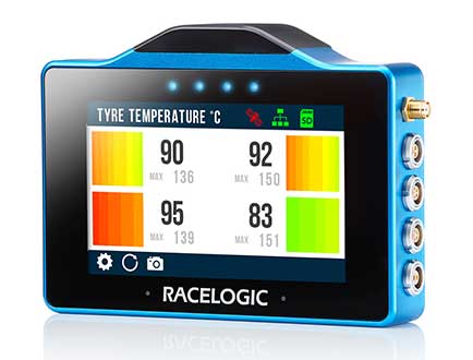
The VBOX Touch from Racelogic is the first in a new generation of highly flexible, enhanced accuracy GNSS dataloggers. The powerful hardware can be used in many types of diverse automotive tests such as acceleration, braking, speed verification, tyre temperature monitoring, lap-timing and durability, according to the company.
The VBOX Touch comes preloaded with a sophisticated performance application that covers many common use cases. Other applications can be downloaded free of charge from the Racelogic online library. Racelogic can also write custom scripts based on customer requirements.
The VBOX Touch has a daylight readable colour touchscreen, 10-Hz GNSS engine, Wi-Fi, Bluetooth, twin CAN ports, serial port, digital input and four multi-color LEDs.
Applications are written in Python script, offering greater flexibility as well as the potential for users to write code to solve their specific testing requirements. If you need a configurable, touchscreen display which can interact with two different CAN buses, log data, know the precise position and speed whilst giving clear feedback to drivers, then the VBOX Touch is for you.
A high-accuracy 2-cm RTK GPS version is available, which uses the latest dual-frequency GPS, GLONASS and Galileo signals to deliver accuracy even under difficult conditions. These new signals significantly increase the RTK resilience near trees and tall buildings, providing precise lap-timing, position triggers and trajectory maps in places where 2-cm GPS has typically not been available.
Founded in 1992, RACELOGIC are based in Buckingham, UK, and have supplied the Automotive industry with reliable and accurate GPS dataloggers for the last 18 years. In the development of the VBOX Touch we have worked closely with our end users to create a powerful tool to help them deliver results faster and more accurately on the test track or open road.
For years, when I was the GIS manager for the Atlanta Regional Commission (ARC), I’d get an annual visit from the Layton Graphics sales rep trying to sell me something. Layton Graphics was an Atlanta blueprint company. I never needed blueprint services so I politely listened and sent the sales rep on his way. In 2005 that changed when the sale rep demonstrated his company’s eye-opener GeoPDF, a significant leap in GIS-enabled map publishing. With the invention of the GeoPDF, the company was reformed as TerraGo, and the rest, shall we say, is history.
Screenshot of Edge on an iPhone showing data capture points in red and current location in blue.
Until GeoPDFs, we published our GIS data as Shapefiles on CDs and relied on users to display the data correctly using their own GIS software. Since many new GIS users had no cartographic training the resultant maps frequently looked terrible or, even worse, completely misrepresented the data. As the publishers of the raw data, we frequently got blamed for some very crappy-looking maps- including those created by our own ARC transportation and land-use planners. GeoPDFs changed that since the cartography remained intact. Not until Esri’s Map Publisher, now ArcGIS Publisher, and subsequent cartographic tools was cartography preserved as the originator intended.
A GeoPDF was a single Adobe document that bundled GIS data, imagery and resultant maps into one compact file with no lost data files, no improperly displayed data and no incorrect data pointers. The Acrobat file was, in effect, an interactive GIS map display that permitted a user to pan, zoom, turn layers on and off, view, import social media and navigate 3D models and many other functions in one single compact file. GeoPDFs proved so valuable that they became the Army’s and other federal agencies’ geospatial publication method of choice.
The Next Geospatial Leap
Recently, TerraGo made another geospatial technology leap, doing for geospatial data collection what the company did for geospatial data display. TerraGo streamlined and sped up geospatial data collection with its new product, TerraGo Edge. TerraGo Edge is a cloud-based application that works on PCs, tablets and even smartphones. A user downloads the app and can then build a data-collection environment that is completely tailored to the needs of an organization. Field personnel can then rapidly collect enterprise data using a PC, tablet or smartphone with very little training and no additional software. The application permits the collection of tabular data, photographs, video clips and more that are georeferenced using the mobile device’s built-in GPS to locate each data point. All data is saved in the cloud and instantly shareable with designated users.
Now the even better news: If the network connection is lost or weak, the field collection can continue in the disconnected environment. The collected data is stored locally, then automatically synced when the connection is restored. The simplicity of the system and disconnected use may help make the Army’s Future Combat Systems vision, in which each soldier is a data user and data collector, a cost-effective reality.
Field Test
Bryan Burns of TerraGo collects data with his iPhone and Bluetooth-connected Bad Elf GPS.
I had to see the system in actual operation, so I paid a visit to the TerraGo Atlanta offices last week. Scott Lee and Bryan Burns of TerraGo gave me a full demo. I previously loaded the TerraGo trial app on my iPhone, which you can also do by going to your app store and downloading the free trial application. The software is fairly intuitive, and I was able to shoot a georeferenced picture and record some notes on my own. Bryan and Scott demonstrated the more advanced Edge features, especially the creation of custom collection forms that greatly speed data collection by field users.
Form creation is an important aspect of Edge, because it not only speeds data collection, it also reduces the chance of errors. As most of you know, sloppy data capture can really corrupt a database. Poor spelling, missed keystrokes, etc., can make database searches difficult and even result in missed records. Developers have found that entry errors can be minimized and collection speed enhanced with several simple data collection tools and techniques that are part of TerraGo Edge. Some of these include the use of pull-down menus for frequently used terms, numeric/alphanumeric entry key restrictions, checkboxes, the use of “radio buttons” for multiple choices, and others. As a result, field users can collect data as quickly as they can walk from one location to another with minimal data entry errors or corruption.
How Much Does It Cost?
$360 per year, with up to three devices. If you want TerraGo to host your operation, storing and backing up your data, that’s another $360 per year. The only additional cost, assuming you already have a smartphone, is additional GPS hardware to achieve better accuracy than the native 5 meters of a smartphone. The additional hardware cost depends on your accuracy needs. A Bad Elf plug-in device gives you 2-meter accuracy for $300 and 1-meter accuracy for $600. Better is a sub-meter accuracy iSX Blue II for $2,000, and even an RTK centimeter system, the EOS Arrow 200, for $6,000. This graph shows the hardware comparisons.
Keep in mind that the GPS units permit data collection even if disconnected, and all available GPS metadata is captured with each fix, so additional post-processing could be done at a later date if needed. The system also comes with a ton of GeoPDF maps, vector data such as OpenStreetMap, WMS feeds and imagery to serve as a backdrop for your data collection. As you would expect, the data you collect can be saved and exported in popular formats such as Esri Shapefiles, KML and GeoPackage, the new OGC handheld standard being supported by AGC and NGA.
How Good Is It?
This image shows the water fountain in front of the TerraGo offices. The green dots show the data points I captured with the Bad Elf Bluetooth GPS.
We then went outside for a short data-collection test using the Bad Elf Bluetooth GPS. It was easy to pair the Bad Elf to my iPhone, and I was able to collect data as fast as I could walk from one location to another. Since this was a short test in the open, I couldn’t judge how quick data collection would be in less than ideal conditions such as building canyons or tree canopy cover. I’d certainly want to spend a day collecting under different conditions to get an accurate feel for the speed, accuracy and reliability of each hardware option in a production environment.
Go to the TerraGo website for a much deeper dive. Edge looks like it will give the competition a real run for the money, not to mention the very significant smartphone accuracy improvements being tested in the labs. So, in short, you can have in your hand a networked GPS datalogger with up to cm accuracy that can operate in a disconnected environment. It seems like smartphones are slowly replacing our stand-alone devices — watches, media players, digital/video cameras, car navigation, compass, level, PC and flashlight. I can even use my iPhone as a magnetometer. Now, even high-end GPS dataloggers are in the smartphone crosshairs.
A good way to see TerraGo Edge in action will be the GPS World webinar at 1300 EDT May 28. Registration is free.
P.S. With Mother’s Day and Memorial Day coming up soon, I’d like to call your attention to my column last year. We frequently read about the bravery and hardships of our military, but the families at home not so much. The mother in the column was so selfless I can’t forget her. You won’t either.
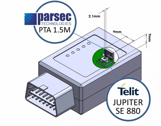
Telit Wireless Solutions and Parsec Technologies today announced that a combination of the companies’ technologies results in a low profile companion solution for GPS receiver and antenna. For host devices able to accommodate higher volumetric symmetry, assembly of the components can be made to fit a 6 x 16 x 8 millimeter volume. A flat component arrangement can yield an ultra-low-profile volume of 6 x 16 x 2.4 millimeters.
“Receivers combining the Parsec PTA/PT Family and Telit’s Jupiter SE880 modules deliver good user experience in finished LBS (location-based services) critical products without sacrificing design flexibility, ease of implementation or cost,” said Michael A. Neenan, CEO and founder of Parsec Technologies, Inc. “The combination is ‘bullet-proof’ in providing a rewarding design experience making RF work reliably, passing end-product regulatory compliance testing without re-test.”
“Miniaturization is a major enabler of new application areas for positioning and M2M,” said Taneli Tuurnala, Vice President and Head of GNSS Division of Telit Wireless Solutions. “With the Parsec antennas, the complete receiver features the industry’s ‘smallest landed footprint,’ making it suitable for use in wearable electronics, UBI devices or adapters for the mobile computing industry.”
Along with miniaturization, the receiver outperforms top traditional designs, handling a loss of 10 dB or greater in GPS signal reaching, for example, the typical OBD port under a vehicle’s dashboard where many usage-based insurance (UBI) dataloggers are installed. The PTA1.5M active antenna delivers the ultra-sensitive Jupiter SE880 micro receiver over 15 dB of additional gain in the operating frequency range. Both companies are making available complete application notes to simplify the engineering effort for system integrators.
The miniature 4.7 x 4.7 millimeter LGA (Land Grid Array), SiRFstarIV-based Jupiter SE880 receiver module employs heterogeneous 3D integrated technology to achieve best-in-class performance in all dimensions critical for regular or size-constrained GPS applications. Its RF front-end employs spatially calibrated waveguide-quality radio paths inside the three-dimensional space of its architecture, reducing parasitic impedances characteristic of traditional 2-D RF designs. Inside, a multi-filter system includes not only the traditional SAW filters typical in GPS receiver designs but also a 2.4-GHz notch-filter capable of nullifying the jamming effects of high-energy radio devices such as Wi-Fi hot-spots, Bluetooth systems, cordless phones, and others, which greatly affect a GPS receiver’s ability to resolve timid satellite signals in the hostile radio environment where they need to operate.
The PTA1.5M, with a gain of 15dB, and PTA1.5x2M, with a gain of 30dB, are tiny GNSS active antenna modules capable of receiving signals down to -192 dBm with frequency centered at 1575.42 (±1.023) MHz. Either model delivers a radiated efficiency greater than 60% when mated to the Jupiter SE880 receiver. Parsec’s PT1233D LNA also has the highest available IP3 at low voltage, helping eliminate interference. Both PTA1.5M and PTA1.5x2M can incorporate the antenna element, an optional SAW filter, the cascadable PT1233D LNA, matching and passives components, on a low cost, easy to integrate 10×16 mm single sided PCBA with “back side” copper clad ground plane. The height of the PTA1.5M and PTA1.5x2M modules vary according to application, allowing their use in even the smallest form factors including Intel’s M.2 Next Generation Form Factor (NGFF) module (23x30x2.4 mm, LxWxH).
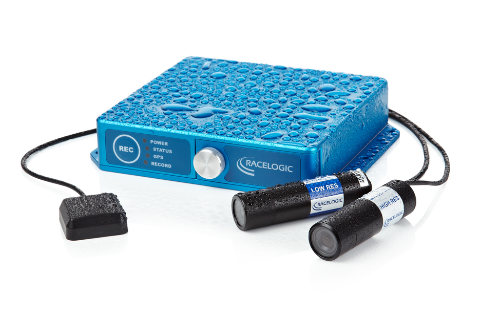
Video VBOX Waterproof by Racelogic combines a powerful GPS data logger with a high-quality multi-camera video recorder and real-time graphics engine, allowing users to carry out detailed driver training and vehicle analysis whatever the weather. Housed in a water-resistant anodized aluminium casing (IP66), Video VBOX Waterproof incorporates a flange and mounting holes to permit users to bolt the system anywhere on their vehicle.
The unit takes video from up to two bullet cameras and combines it with a customizable graphical overlay, recorded on to SD card or USB stick in DVD quality. It is designed for a variety of applications from automotive testing to motorsport, driver training, and industrial applications.
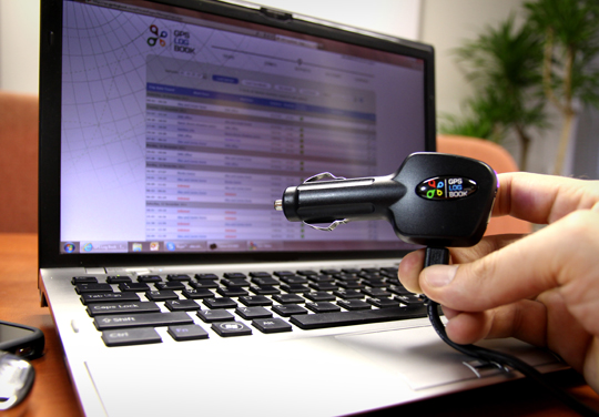
Digital Matter Embedded, a South African based provider of innovative technology providing electronic and software solutions for a wide range of Industry applications, has launched a compact GPS logging device which plugs into any vehicle’s cigarette lighter. The device, the GPS Log Book, is designed around u-blox’ NEO GPS receiver module to provide an easy way for drivers to automatically keep an accurate travel log book which can be securely accessed later from anywhere via a web interface. Information logged includes route, speed, and distance traveled. The device is targeted at businesses where tracking of vehicle usage is an important part of their cost control and accounting: taxi, emergency, and delivery services, as well as for traveling sales personnel.
“The GPS Log Book takes advantage of u-blox’ extremely sensitive GPS receiver technology to provide a simple and useful way to keep an accurate overview of vehicle usage,” said Alex Soldatos, general manager at Digital Matter Embedded. “The GPS Logbook provides a simple, cost-effective way for businesses to keep track of one of their most valuable assets: their cars.”
“The GPS Log Book takes full advantage of u-blox’ leading positioning technology: it requires fast satellite acquisition and re-acquisition speeds, small module size, and high sensitivity to allow the use of a very small GPS antenna,“ said Huub Robroek, regional sales manager at u-blox. “Basing their design on our NEO GPS module has resulted in an impressive, compact device that delivers useful and reliable vehicle usage data.”
The GPS Log Book uploads its log data on both PC or Mac via USB where a web interface application allows users to manage their devices, view trips, and add locations as well as many other useful functions including creating powerful, informative reports. Most notably, the log book can be generated for use with income tax return for individuals. Data is stored for more than five years and can be viewed at any time if required.