AUVSI has launched Green UAS, a program to expand the amount of commercial UAS that have been verified to meet high levels of cybersecurity and National Defense Authorization Act supply chain requirements.
Green UAS meets the Blue UAS certification program of the Defense Innovation Unit. It is designed for users who do not immediately require Department of Defense authority to operate.
Green UAS also offers a streamlined pathway to the Blue UAS 2.0 cleared list.
Green UAS is suitable for users who rely on commercial, off-the-shelf UAVs to conduct diverse operations. These users include federal government agencies, local law enforcement, first responders and state departments of transportation.
Green UAS is also suitable for industrial enterprise users such as energy and utility companies, telecoms, manufacturers, food and agriculture, and logistics and mapping/surveying companies.
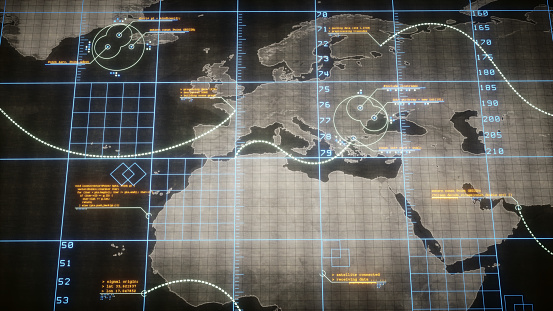
A new platform will detect and characterize GNSS spoofing operations using artificial intelligence and commercially available data
Geospatial intelligence company Orbital Insight has been awarded a contract from the U.S. Department of Defense (DoD) to deliver a technology platform for identifying intentional GNSS interference and manipulation operations across the world.
The platform will leverage commercially available data to detect GNSS spoofing, where falsified or manipulated GNSS signals are used to confuse adversaries or obscure illicit activities, presenting risk to both government and commercial operations. Orbital Insight was selected through DoD’s Defense Innovation Unit (DIU) solicitation process seeking commercial solutions to counter the growing threat of GNSS disruptions to national security.
Research suggests that Russia conducted nearly 10,000 spoofing operations from 2016 to 2018 alone.
The new technology will significantly improve situational awareness for warfighters, intelligence analysts and safety-of-life applications. Orbital Insight’s platform will leverage its multisensor data stack, artificial intelligence and machine-learning capabilities to alert analysts and operators to potential jamming and spoofing events, techniques commonly used by adversarial actors to cover up activities or sabotage operations.
The platform leverages a suite of geolocation data — satellites, AIS, ADS-B and internet-of-things devices — along with new advanced algorithms designed to automatically recognize anomalies linked to spoofing, complemented by research intelligence from the nonprofit partner Center for Advanced Defense Studies. Research suggests that Russia conducted nearly 10,000 spoofing operations from 2016 to 2018 alone.
“Helping organizations understand what’s happening on and to the Earth is at the heart of what Orbital Insight does, and spoofing is a national security problem that has proven challenging to solve,” said Kevin O’Brien, CEO, Orbital Insight. “GNSS spoofing is essentially a data problem, and Orbital Insight’s AI and deep data stack can help identify spoofing, along with other major humanitarian and environmental challenges. This is a perfect example of private and public sectors uniting through technology.”
Other areas that may be addressed: identifying drug trafficking, illegal fishing, sea-borne piracy and unintentional commercial aviation disruptions
The technology has broad implications that extend beyond situational awareness of intentional GNSS interference. Other national security, humanitarian and environmental challenges may be addressed, such as identifying drug trafficking, illegal fishing, sea-borne piracy and unintentional commercial aviation disruptions.
Federal agencies are increasingly complementing their systems with commercial technology and data sources that are unclassified, universally accessible, and shareable with allies. The National Air and Space Intelligence Center will be the first customer to utilize the technology. Upon successful integration, the goal will be to expand this platform widely across the defense, intelligence and civil communities.
Orbital Insight received the DoD contract on the heels of announcing a Phase II Small Business Innovation Research contract from the National Geospatial-Intelligence Agency to deliver a computer-vision model that uses synthetic data to detect novel classes of objects.
The company also recently launched a new class of multiclass object-detection algorithms within its flagship GO platform to help the intelligence community monitor and differentiate activity at thousands of areas of interest. Like all of Orbital Insight’s products, these algorithms are being developed within an ethics framework that shapes the company’s work and values privacy.
The U.S. Department of Defense wants help making sense of commercially and publicly available information that could be used to detect GNSS disruptors, especially over large areas.
Obtaining the ability to detect and geolocate GNSS disruptions has been cited as an unmet need in a number of U.S. national policies and plans dealing with positioning, navigation and timing.
The recently posted solicitation calls the project “HARMONIOUS ROOK – Situational Awareness for Intentional Disruption of Global Navigation Satellite System (GNSS) Users.” The solicitation says:
“The Department of Defense (DoD) seeks commercial solutions leveraging machine-driven analytics and datasets derived from publicly/commercially available information (PAI/CAI) to provide a situational awareness capability for intentional global navigation satellite system (GNSS) disruptions. This solicitation is particularly focused on persistent, large-area coverage of falsified GNSS emitters that result in localized spoofing phenomenology.”
Studies and analyses by non-profit organizations and commercial entities have demonstrated the ability of non-governmental organizations to do this kind of work and produce remarkable results. In 2017, our Resilient Navigation and Timing Foundation detected and reported on widespread GPS spoofing in the Black Sea.
This acquisition is being led by the Defense Innovation Unit, or DIU. The unit was specifically created to accelerate the adoption of commercial technology and services by the defense and national security establishments. While letting a traditional DoD contract for a prototype can often take up to 18 months, DIU aims to award contracts within 60 to 90 days of identifying the problem.
To do this, DIU uses the government’s “commercial solutions opening” process, which is designed to be simple and quick.
Companies who provide analytic services and those who have unique data sets are both encouraged to apply. The deadline is August 23.
Dana A. Goward is president of the Resilient Navigation and Timing Foundation
An Interim Armored Vehicle “Stryker” and AH-64 Apache helicopters with Battle Group Poland move to secure an area during a lethality demonstration as part of Saber Strike 18 in June 2018. (Photo: U.S. Army/Spc. Hubert D. Delany III, 22nd Mobile Public Affairs Detachment)
A surveillance system is demonstrated during a Naval Information Warfare Systems Command (NAVWAR) exercise. (Photo: Rick Naystatt/U.S. Navy)
The U.S. Defense Innovation Unit (DIU) is asking for commercial solutions to fight GNSS disruptions, including jamming and spoofing.
DIU is particularly asking for “solutions leveraging machine-driven analytics and datasets derived from publicly/commercially available information to provide a situational awareness capability” against intentional disruptions.
Responses to “HARMONIOUS ROOK — Situational Awareness for Intentional Disruption of Global Navigation Satellite System (GNSS) Users” are due by Aug. 22.
DIU is a Department of Defense organization focused exclusively on fielding and scaling commercial technology across the U.S. military to help solve critical problems.
The solicitation is focused on “persistent, large-area coverage of falsified GNSS emitters that result in localized spoofing phenomenology.”
It cites intentional manipulation of GNSS signals as enabling “nefarious activities, to include narcotics trafficking, unapproved operation of autonomous vehicles, illegal fishing and sea-borne piracy.”
“Additionally, nation-state use of GNSS jamming or spoofing systems may extend beyond the area of conflict, causing deleterious effects on civilian populations,” the solicitation states. “Such activities degrade or deny critical geolocation capabilities and further introduce hazards to safety-of-life-navigation, critical infrastructure, and emergency response services. “