Tag: Defense PNT

  • The promises of M-code and quantum

    November has certainly been a busy month, and I’ve been lucky enough to be involved in a number of standout events where defense PNT was discussed.

    The National Space-Based Positioning, Navigation, and Timing (PNT) Advisory Board met in California; GPS World hosted a webinar on military PNT technology; and the International Navigation Conference took place in the U.K. Check out a brief roundup of what’s been taking place.

    Next-generation GPS takes steps in the right direction

    The December issue of GPS World magazine has an excellent update from Col. Steven Whitney. GPS itself is often referred to as the “gold standard” by which other GNSS and PNT solutions are benchmarked. And GPS is undergoing a fairly monumental modernization program, in order to stay current and provide the right services to the military. There are broadly three aspects to this: the next-generation ground segment, the space segment, and the user equipment.

    It’s fair to say that the ride hasn’t been a particularly smooth one, and the Next Generation Operational Control System (OCX) has been plagued by delays and challenges. Following a Nunn-McCurdy breach in 2016, the future of the OCX development program looked to be hanging on a knife edge, but the program was recertified and continued.

    At the PNT Advisory Board meeting on Nov. 15, Col. Gerry Gleckel (deputy director, GPS Directorate, Space & Missile Systems Center) gave an upbeat presentation on the status of GPS modernization. Describing the current status of OCX as “working through program challenges,” he described how the first integrated launch rehearsal between GPS III and OCX Block 0 had been completed in August.

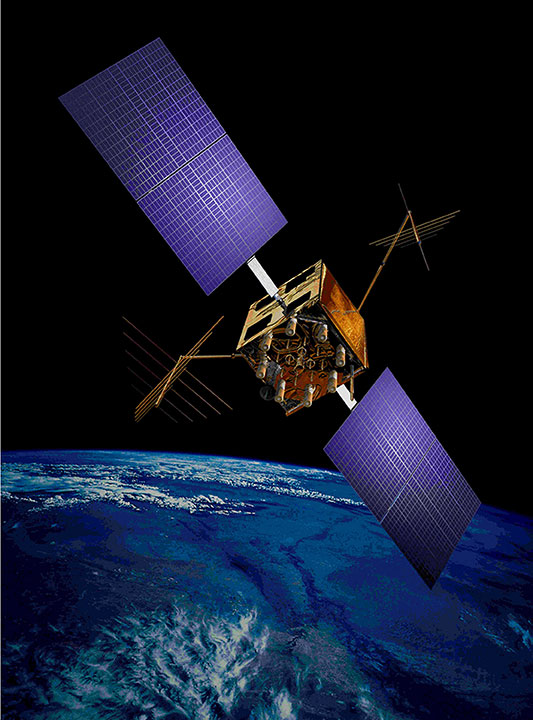
    The GPS III satellites themselves are in full production flow, with five satellites at various stages of assembly.

    Figure 1. Five GPS III satellites are in production flow. (Credit: Gerry Gleckel, Nov. 15, 2017).

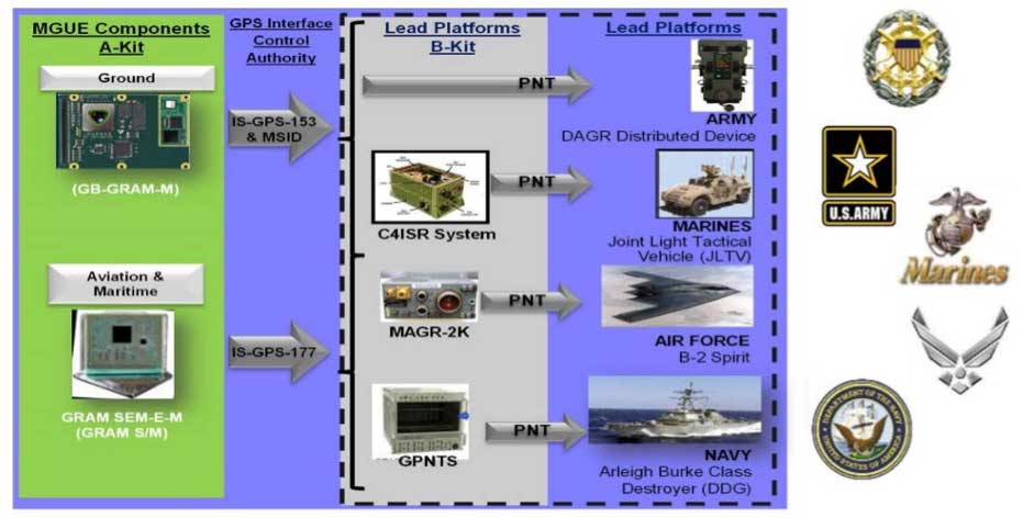
    The next-generation military receivers, known as Military GPS User Equipment (MGUE), are also under development by a range of vendors, of which L-3 Technologies was the first vendor to receive security certification in 2016. A number of equipment form factors are being developed to address land, sea and air platforms, and great progress is being made.

    Figure 2. Military GPS User Equipment (MGUE) will address a range of platforms. (Credit: Gerry Gleckel, Nov. 15, 2017)

    The U.S. Air Force recently completed a number of successful test flights of a prototype M-code receiver on board a B-2 stealth bomber, which marks an important milestone for the GPS modernization effort. Let’s remind ourselves what M-code is, and what it does for us.

    The promise of M-code

    Until now, the military has relied on the encrypted P(Y) code to provide advantage on the battlefield. Compared to the civilian C/A code, the P(Y) offered improved accuracy, ionospheric correction, resistance to spoofing and a marginal level of jamming resistance.

    M-code is quite a different picture. Rather than the traditional BPSK modulation schemes used by legacy signals, M-code utilizes a type of binary offset carrier (BOC) signal. In the case of M-code, the signal is a BOCsin(10,5) modulation, which has a power spectral density given by:

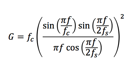
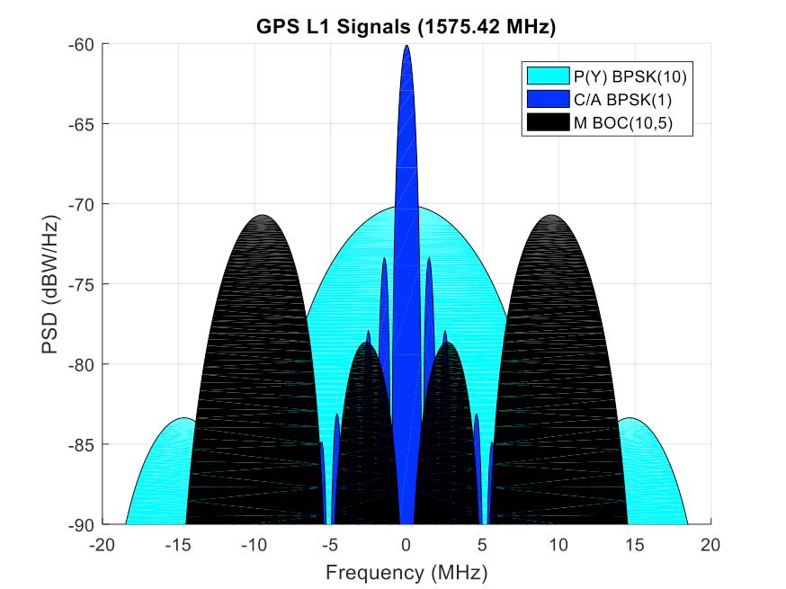
    This power spectral density can be seen in the figures below, along with legacy C/A and P(Y) codes (and also the new L2C signal on L2). The M-code BOC signal has a number of important properties; I won’t describe all of them, but I will pick out a couple.

    Firstly, the signal is able to support navigation warfare activities. Because the energy in the signal is spread in two lobes away from the center, it allows for the C/A code to be selectively jammed without affecting the military receivers. This is often referred to as “blue force jamming” or “blue on blue jamming,” where friendly forces might wish to perform jamming in an environment in which they are themselves operating. Currently, such blue force jamming is not possible with P(Y) code receivers, without also degrading the friendly force’s receiver.

    Another promise of M-code is the ability to use spot-beam transmissions from Block III satellites. This is where a high-gain antenna on the satellites aims the M-code signal at a specific region of the earth, with much greater received satellite power in that region. The received signal from the spot beam is expected to be around 20-dB more powerful than the conventional full-Earth coverage beam. This means that, in a given conflict region, military GPS receivers should be able to benefit from a large increase in jamming resistance.

    Figure 3a. M-code signal compared to traditional L1 GPS signal. (Image: Michael Jones)
    Figure 3b. M-code signal compared to traditional L2 GPS signal. (Image: Michael Jones)

    Shortly after the GPS Advisory Board meeting in California, on the other side of the Atlantic a range of defense PNT technologies was also discussed.

    International PNT experts gather in the UK

    The International Navigation Conference (INC 2017) is now in its third year, and has been steadily growing in prominence. This year’s event, which took place Nov. 27-30, focused on the themes of resilient PNT, autonomy, and sensor and data fusion. As usual, there was a substantial defense presence.

    I had the pleasure of chairing a few sessions, including a panel discussion on resilient PNT. The event began with a cross-government meeting, where representatives from across the UK government met to discuss PNT issues concerning defense and national security.

    What I loved about this conference is the sheer diversity of PNT topics that were discussed. In the military domain, it wasn’t just the traditional subjects of GNSS, inertial, visual and signals-of-opportunity that were discussed. Also considered was cognitive navigation — how does a soldier’s brain work when in an unfamiliar battlefield? And how will quantum technology benefit defense PNT in the medium to long term?

    The promise of quantum

    Quantum technology has for some time been touted as the future of PNT: clocks so accurate that you’ll never need to worry about timing again. Inertial measurement units that have so little drift, you’ll never need anything else for navigation.

    If you’re not familiar with quantum technology, let me explain. Quantum technology exploits science that cannot be explained by classical physics, such as Newtonian mechanics, thermodynamics and Maxwell’s electromagnetism.

    As atoms get colder, they have lower energy levels and move more slowly. Taking this argument all the way down to absolute zero, the atoms would stop moving. By using lasers to cool atoms to very near absolute zero, the atoms are essentially placed under precise control, and hence are sensitive to changes in the local magnetic and gravitational fields. What does this mean for navigation?

    An excellent INC 2017 session on quantum navigation revealed some of the answers. Dr. Tim Freegarde of the University of Southampton gave the keynote “Navigator’s Introduction to Quantum Technologies,” which was followed by sessions on quantum/classical combined navigation, and quantum technology for performing gravity gradient map matching.

    Quantum sensors rely on a phenomenon known as entanglement, where two physically separated systems are linked in such a way that a measurement of one affects the results of the other. Once atoms have been cooled, they can be made to travel in opposite directions around a loop, where the interference pattern generated allows rotation to be sensed.

    But the atoms can also be sensitive to gravitational and magnetic fields, and frequency. So, amongst many other things, quantum technology allows for more accurate atomic clocks, and rotational and gravitational sensors.

    A huge amount of money has been poured into quantum research in recent years and, whilst it’s clear there is still a long way to go, progress is certainly being made. At the UK National Quantum Technology Hub in Sensors and Metrology, the focus is on achieving sensors that are useful, and not necessarily to look for the highest possible precision. This is essential if quantum sensors for PNT are to be adopted by governments and industry.

    Cyber takes center stage

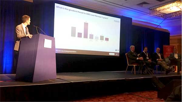
    At the end of the conference, I had the pleasure of chairing a lively panel discussion on resilient PNT, where I put a number of questions to both the panel and the audience.

    Coming back to satellite navigation, my first question was, “What is the greatest threat to GNSS over the next three years?” You may be forgiven for thinking that “jamming” or “spoofing” was the top answer because, no, the top answer was in fact “cyber attack”.

    Figure 4. At the International Navigation Conference, the audience voted “cyber attack” as the greatest threat to GNSS. (Photo: Michael Jones)

    But what exactly do we mean by “cyber attack”? The word “cyber” is a pretty loose word, which is often misused as a catch-all phrase to cover anything that’s not RF related. Let’s quote the NIST definition of cyber attack:

    “An attack, via cyberspace, targeting an enterprise’s use of cyberspace for the purpose of disrupting, disabling, destroying or maliciously controlling a computing environment/infrastructure; or destroying the integrity of the data or stealing controlled information.”

    How does this apply to military PNT? Well, a key theme from the conference was the trend towards more complex PNT systems. No longer do we have a simple GPS receiver, but an ever-increasing mix of different PNT sensors, and a system more comparable to a computer than a traditional GPS receiver.

    What this means is that modern and future military PNT will be susceptible to the full range of cyber attacks currently associated with computing environments. Guy Buesnel from Spirent Communications gave an excellent keynote presentation where he covered this topic. Describing the “attack surface” for GNSS, he noted how many GNSS receivers currently run embedded operating systems such as VxWorks or Linux, and many support standard protocols such as TCP/IP and USB, all of which leaves them vulnerable to cyber attacks.

    But let’s not despair. The good news is that there is an awful lot to learn from the computing domain. After all, when computers first became vulnerable to cyber attacks, we quickly learned to make use of virus checkers, firewalls and other such mechanisms available to us. And now the domain of cyber security gives us an arsenal of defensive measures to combat cyber-space risks.

    I’ll finish by returning to the PNT Advisory Board meeting in California on Nov. 15, where Harold Martin, director of the National Coordination Office for Space-Based PNT, said “GPS is more computer than radio… GPS receivers lack cyber resilience. This is a national issue.”

    Don’t forget it.


    Equation figure: Michael Jones

  • In defense of PNT: Multi-GNSS to the rescue

    In defense of PNT: Multi-GNSS to the rescue

    An artist's concept of a GPS IIR-M satellite in orbit (courtesy of Lockheed Martin).
    An artist’s concept of a GPS IIR-M satellite in orbit (courtesy of Lockheed Martin).

    For more than 41 years, many of us who were there in the beginning have been discussing the attributes, capabilities, enabling features and shortcomings of GPS and other space-based PNT (position, navigation and timing) systems. You have likely heard most of them; historically they go something like this:

    • The signal is weak.
    • The signal is easily jammed.
    • The signal can be spoofed.
    • The signal is subject to atmospheric perturbations.
    • The signal doesn’t penetrate buildings.
    • The signal doesn’t penetrate dense canopies (urban or natural).

    I am sure you have heard most of these. Now, allow me to update the situation with some of the developments enabled by modern signals, new techniques, and multi-frequency, multi-GNSS (Global Navigation Satellite System) “all-in-view” receivers. All of the above bulleted statements are still true, but to a lesser extent, virtually each day. As some well-known pop musicians once sang, “It’s getting better all the time.”

    • Today,  multi-GNSS signals in a fully modern multi-GNSS receiver can to some degree resist interference — intentional (jamming) or unintentional — and  spoofing. It is extremely difficult for a jammer or spoofer to disrupt GPS, GLONASS, Galileo and BeiDou all at the same time. And more help is on the way.
    • Today, multi-GNSS signal corrections remove a large amount of error due to atmospheric perturbations and can sometimes deliver centimeter and millimeter accuracy in real time (in the case of short-baseline real-time kinematic (RTK) using only L1 carrier-phase as data, and/or in some other special situations.)
    • Today, multi-GNSS signals and augmentation signals show some improvement in penetrating dense canopies and canyons by virtue of their multiplied numbers and dispersed geometry.
    • Today, new ground-based technologies show promise at penetrating buildings to provide indoor location. When combined with GPS/GNSS, this is starting to get us closer to the Holy Grail, the ubiquitous PNT solution.

    Debate

    The future looks bright for PNT solutions, ground and space-based. I know it all sounds like a debating society, and you may have heard some of these arguments before. My point, my premise if you will, or bottom-line-upfront in military parlance, being: the GPS (space-based) limitations of the past are gradually giving way to the improved multi-GNSS capabilities of today and the combined ground-based and space-based PNT technologies of the present and rapidly arriving future.

    Unfortunately, there are many uninformed so-called PNT pundits who love to posture for the press — and who are living in the past. The future is right in front of them, or in many cases in their hands, and they cannot or will not acknowledge its existence.

    It’s all in the numbers

    Current estimates are that more than 4 billion users depend on PNT daily for position, navigation and timing, or the multitude of services each of these resources enables. More than half of that number is attributable to smartphone users, which means, at a minimum, more than 2 million PNT users have a two-way communications device incorporated into their PNT receiver/sensor.

    Let’s look at current high-end smartphones as examples of commercial multi-frequency, multi-GNSS “all signals available” devices. The user has a true multi-GNSS device incorporating:

    • GPS — Global Positioning System, United States government
    • GLONASS — Globalnaya Navigazionnaya Sputnikovaya Sistema, the Russian space-based PNT system
    • BeiDou — the Chinese BeiDou Navigation Satellite System, a regional system now, soon to be global (2020 the advertised date).

    with augmentations such as

    • WAAS — U.S. Wide Area Augmentation System
    • EGNOS — European Geostationary Navigation Overlay Service
    • Other SBAS — additional Satellite-Based Augmentation System signals by region
    • Wi-Fi — Signals compatible with a set of broadband wireless networking standards.

    The latest high-end smartphones incorporate an inertial system, a digital compass, a rate gyro, and a pressure sensor integrated with pedometer software that keep track of position, heading and velocity when  external signals are lost. Add cellular tower and network-enabled positioning and timing technology, and you have a two-way communications and PNT-based multi-GNSS sensor that, as long as it has power, is never lost.

    Atomic numbers

    The rubidium-based (atomic-reference system) timing signals from GPS satellite vehicles (SV) are among the most stable timing frequencies ever broadcast from space. The true accuracy of the signal in space is classified, but approaches an accuracy 10 times better than what was once thought to be adequate for our warfighters.

    The best clocks in any current GNSS system are the passive hydrogen masers of Galileo. Thus a PNT set-up that adds Galileo to GPS improves in more ways than one.

    Ephemeris numbers

    Twenty-five years ago, the U.S. military kept track of GPS satellite orbit locations (known as the ephemeris of the satellite) using actual GPS measurements at the control segment tracking stations. The GPS satellite ephemeris was known to a much lesser degree of accuracy than now. At the time, that accuracy was  considered good enough.

    Today, the ephemeris is known much more precisely, and this can be on the order of some centimeters. This has to do with not only the location of the satellite’s center of mass (c.o.m.), but the actual location from which the signal is broadcast. The position of the satellite’s broadcast antenna is known reasonably well most of the time, by very high-end users, after correcting for the arm lever between the c.o.m. and the antenna phase center. The c.o.m. itself can vary by some centimeters over time because of depletion of onboard expendables, but here we are getting into very high-order minutiae.

    Suffice it to say that certain multi-GNSS scientific high-precision receivers today are used to measure tectonic movements on the order of centimeters over the course of a full year.

    Number of signals

    Just recently, with the addition of certain QZSS signals (the Japanese Quasi-Zenith Satellite System) along with the Indian (GAGAN) and Russian (SDCM) equivalents of WAAS and EGNOS, the number of multi-GNSS PNT signals available to a truly international multi-GNSS receiver exceeds 200. For example, one set of global commercial receivers routinely receive and process more than 190 PNT signals in a six-hour period. The receivers are both static and dynamic, and they are networked. The static receivers know their actual location to within millimeters, and use this location as a truth set from which all other signal data is compared.

    Accuracy numbers

    For our example (and all parameters are software-defined and user-programmable), the location parameter may be set at 10 centimeters, meaning that any position derived from PNT signals or augmentations that differ by more than 10 centimeters from the “truth set” are immediately rejected, and that data is broadcast on the systems network, which keeps the dynamic receivers in sync as well.

    The individual receivers each contribute to their own and a networked website with metadata usable by Kalman filters to which other users may choose to subscribe. This makes the multi-GNSS receivers not only receivers, but system and PNT monitors and sensors that can detect  jamming, interference and spoofing attempts, which are reported.

    This monitoring and tracking system is constantly evolving and incorporating new technologies while becoming more secure everyday. This is not a totally new concept, as the core system is a mature enterprise system that has been in operation and commercially viable for more than seven years.

    This should be comforting information for those of you who stay up at night worrying about the safety of autonomous vehicles on land, sea and in the air.

    Don’t let me give you the impression that GPS is just waiting around for other GNSS to come to its aid. GPS is aggressively modernizing itself. In Air Force parlance, “GPS III space vehicles will introduce new capabilities to meet higher demands of both military and civilian users.” As stated by GPS III contractor Lockheed Martin, the modernized system will:

    • Deliver signals three times more accurate than current GPS spacecraft.
    • Provide military users up to eight times improved anti-jamming capabilities.

    Augmentations and improvements

    The bottom line is that a greatly increased number of space-based PNT platforms — along with quantum improvements in computing power, cheap non-volatile memory and software-defined capabilities — have produced a multi-GNSS PNT capability that increases availability via sheer numbers, with more security and reliability on the way.

    A pair of LocataLite transmit antennas overlook a section of the White Sands Missile Range blanketed by the Locata high-precision ground-based positioning system.
    A pair of LocataLite transmit antennas overlook a section of the White Sands Missile Range blanketed by the Locata high-precision ground-based positioning system.

    We are rapidly developing a PNT system that goes far in countering the naysayers. It takes advantage of augmentations and complimentary systems such as newer versions of Loran, (Long-Range Navigation System) and local PNT implementations such as Locata, just to name a couple of examples.

    These ground-based systems are critical to the future of PNT, and have very strong signals. For instance, eLoran is extremely difficult to jam, if not actually unjammable. If a monstrous sunspot were to temporarily knock out the majority of space-based systems, the ground-based systems would more than likely still be available, if — big if here — they are fully developed. At the moment, this is not a sure thing. It is a work in progress.

    Ground-based augmentations and complimentary/backup systems can in the future add a level of security for GPS and other space-based PNT systems: Why bother trying to knock out these space-based systems when there is a suitable and readily available ground-based system as a backup?

    The U.S. government maintains a number of monitor stations around the globe. However, it has not historically taken advantage of the incredible capabilities of multi-GNSS receivers and sensor technology. Although NASA and other U.S. non-military agencies have been involved with multi-GNSS — specifically the Russian GLONASS — for the past 20 years or so, the use has not been widespread. Fortunately, recent changes now permit multi-GNSS receivers for government users, including the military, in certain non-targeting activities, and the government would do well to take advantage of the changes. The good news is that the majority of the capability is in the receiver design, a capability on which the current director of the GPS Directorate at the Space and Missile Systems Center (SMC) “made his bones.”

    To all those critics who take every opportunity to denigrate space-based PNT, both inside and outside the government, I say: Pay attention to multi-GNSS. Stop your diatribes, because the future is arriving. Secure space-based PNT systems are here to stay.

    They continue to improve and become more secure as they incorporate space- and ground-based augmentations, new PNT technologies, software-defined capabilities, multi-GNSS signals, and enhanced computing.  “It’s getting better all the time.”

    Allow me to repeat myself all over again. Space-based PNT is here to stay.

    Until next time, happy navigating, and remember: GPS is brought to you free of charge by the United States Air Force.

  • What to Do, Who to See at the 31st Space Symposium

    What to Do, Who to See at the 31st Space Symposium

    Logo: 31st Space Symposium

    As I write this, the 31st Space Symposium (SS) will kickoff in just 5 days, on April 13 at the incomparable Broadmoor Resort in Colorado Springs, Colo., at the foothills of the beautiful Rocky Mountains.

    Neil deGrasse Tyson (courtesy of PBS)
    Neil deGrasse Tyson (courtesy of PBS)

    If you haven’t figured it out already, the 31st SS is not a WWII German unit designation, but the 31st Space Symposium, which Dr. Neil deGrasse Tyson, famed astrophysicist, bestselling author, director of the Hayden Planetarium and host of the hugely successful television series Cosmos: A Spacetime Odyssey, simply calls “the most awesome symposium in the world.” Very high praise indeed, and a sentiment with which I totally agree.

    Breaking Records

    This year’s Space Symposium, which is sponsored by the Space Foundation, will be the largest ever held in terms of venue, size (number of exhibitors and speakers) and attendance. Approximately 10,000 space enthusiasts are expected to attend, and I hope you are one of them. My sources tell me the classified sessions (Cyber 1.5 and classified space sessions) are filled to overflowing — no new registrations allowed there. The exhibitor space at the Ball Aerospace Exhibit Center and Pavilion is bursting at the seams. The organizers are turning exhibitors away, so better luck next year. But if you just want to attend the greatest space symposium in the world, bar none, there is still time to register.

    By the way, if you haven’t figured it out already, this is a truly international event. My sources at the Space Foundation stated that the 31st Space Symposium will have more international participation than ever, including more than 150 exhibits of the world’s latest space technology, products and services. The Ball Aerospace Exhibit Center will host more than 30 first-time exhibitors with more than a dozen countries represented, including: Austria, Canada, Denmark, France, Germany, Japan, New Zealand, Norway, Scotland, Sweden, Turkey, the UK and the U.S. The symposium is expected to attract space leaders from more than 25 countries, representing all sectors of the global space community.

    Everyone who is anyone in the space world will probably be there or be represented. Consequently, the networking capabilities are unparalleled. Not to mention just being able to avail yourself of the world-famous Broadmoor Resort hospitality, plus the crisp, clean and cool mountain air at 6,000 feet.

    Event Preparation

    For many years, the event was known as the National Space Symposium. It outgrew that moniker many years ago, and is now simply known as the Space Symposium.

    Every year before I attend the Space Symposium, I make a “ToDoToDay” list of topics I want to explore, both as a journalist and in my senior space analyst profession. Plus, of course, I make a list of people I definitely want to talk with or interview. This year, I thought I would share some of those to-dos with you, because you may indeed have some of the same interests.

    GPS III

    Mark Stewart, Lockheed Martin GPS III program manager (Courtesty of Lockheed Martin)
    Mark Stewart, Lockheed Martin GPS III program manager (courtesy of Lockheed Martin)

    Wearing my subject matter expert (SME) hat, so to speak, I recently had the honor of touring the Lockheed Martin (LMCO) Space Systems facility in Waterton Canyon (far West Denver), Colorado, where the GPS III satellites are built, integrated and otherwise readied for launch. I took the opportunity to chat with Mark Stewart and his crew. Mark is vice president for manufacturing and space systems and program manager for GPS III.

    I learned that the first GPS III space vehicles (SVs) is much farther along than most everyone thinks. The problematic MDU (Mission Data Unit — the heart of the system) from Exelis has been fully tested and integrated into the payload. GPS III SV1 was only three days from being totally integrated or mated, as they say, with the on-orbit propulsion portion of the payload (the remainder of the LMCO A2100 bus) and beginning its months-long testing, certification and verification process. According to Mark, GPS III SV-01 — which powered on initially in February 2013 — now is in integration and test flow leading up to final delivery to the Air Force.

    While it was thrilling to see everything finally coming together, I will also tell you candidly that the next milestone everyone is asking about, the first GPS III launch date, is probably as fluid as the Snake River in Spring. So, while I do not feel comfortable quoting a first launch date, and LMCO would not give me a firm date for delivery of the first GPS III SV, I do feel comfortable making this prediction: Barring any unforeseen major issues during testing, LMCO will be ready to deliver to the U.S. government the first ready-to-launch GPS III satellite by the end of this calendar year. That’s right, in my humble opinion the first GPS III SV will be ready to deliver to the Air Force by December 2015. When it will actually be launched is anybody’s guess; obviously, the sooner the better. Apropos of the Boeing IIF initial launches and critical on-orbit anomalies, the sooner the LMCO GPS III is put into orbit for full-scale operational and mission analysis tests the better.

    LADO and OCX

    The critical question of course is: Will the U.S. Air Force (USAF) have a ground control system that can successfully and reliably launch and support a full-up GPS III SV by the end of 2015? Certainly not if they stay the course with OCX, but there are alternatives, and you know who you are! Can you say LADO, Launch/Early Orbit, Anomaly Resolution, Disposal and Operations System?

    Consider that LADO has been utilized to launch GPS satellites as far back as the GPS IIR-M family of satellites, also produced by LMCO, one of which was successfully launched on October 17, 2007, using the then-new LADO system. That milestone ensured the GPS program continued to provide superior space-based navigation for billions of users, military, civilian and commercial, around the globe using industry-leading highly modified (Aces Premier) commercial launch technology. This significant achievement was the culmination of outstanding teamwork between the USAF, Braxton Technologies, the engineering firm and the prime contractor.

    The LADO system formed and is still the backbone of the new GPS Command and Control (C2) functionality implemented by the prime contractor. It known today as the Advanced Architecture Evolution Plan (AEP). Subsequently, LADO is now the primary launch system for all current and future (IIR-M, IIF and possibly GPS III) satellites, which should allow the U.S. Air Force to retire some outdated legacy GPS ground support and command and control systems.

    The first successful 2007 LADO launch and control of an operational GPS IIR-M satellite, and the 1SOPS and 2SOPS operators’ acceptance of the GPS LADO system, was proof that commercial software can be deployed effectively even in a militarily critical mission system, saving the government both cost and schedule without sacrificing mission-unique capabilities.

    In my humble opinion, that is where we need to go today. Let’s return to the tried-and-true LADO and prime contractor partnership and launch the first GPS III SV by the end of this year, or certainly by early 2016. Please notice I have not made any statements concerning scrapping the hugely expensive, 100-percent-over-budget-and-schedule (years behind) OCX program of record. Under Secretary of Defense for Acquisition, Technology and Logistics (USDATL) Frank Kendall recently announced the controversial decision that OCX as the program of record would go forward under strict scrutiny with definite milestones that must be met. Scrutiny is a fickle mistress, and historically on the OCX program, milestones are there to be missed. Meanwhile, the USAF requires a tried, proven and utterly reliable capability to launch GPS III SVs as soon as the first few become available. The USAF must place several GPS IIIs on orbit for a full checkout to ensure there are no major anomalies. Currently, LADO had an eight-year proven track record with no failures, and it remains the only program that can initiate, control and dispose of residual GPS satellites — including the IIAs, which are the longest lived GPS satellites on orbit today.

    Beware, there will be many naysayers in government circles, and you may meet some of them at the symposium, that will tell you it is just not possible. But just stop by and talk candidly with LMCO Space Systems and Braxton Technologies personnel, and see what they have to say. You may be surprised by what you hear.

    Then stop by the Raytheon booth and check on the status of OCX.

    Lynn Dugle (courtesy of Raytheon)
    Lynn Dugle (courtesy of Raytheon)

    Female Executives in the News

    Speaking of OCX and Raytheon, Lynn Dugle retired from Raytheon on March 2, 2015. Historically, Lynn has been a very capable executive. She is the former president of Raytheon’s Intelligence, Information and Services (IIS) business, which handles several key U.S. Air Force space contracts, including OCX, the current program of record for the next-generation ground system for GPS III. Dugle served as president of the division beginning in 2009.

    David Wajsgras (your guess is as good as mine), Raytheon’s former senior vice president (SVP) and chief financial officer (CFO), has replaced Dugle. Wajsgras served as SVP and CFO of Raytheon Company from March 2006 to March 2015.

    David Wajsgras (courtesy of Raytheon)
    David Wajsgras (courtesy of Raytheon)

    As a member of Raytheon’s senior leadership team, he directed Raytheon’s overall financial strategy. In my humble opinion, he has his work cut out for him. He will need all of his financial expertise and acumen to make OCX a success — financially and, hopefully, operationally. The program is grossly over budget, several years behind schedule, and reportedly, my sources tell me, far less capable than originally planned. Good luck, David. 

    As long as we are still speaking primarily of female executives with great track records, USAF Lieutenant General Ellen Pawlikowski, who I have had the honor of knowing and working with for the past 25 years, was recently nominated for her fourth star. General Pawlikowski successfully commanded the SMC (Space and Missile Systems Center) and served as Program Executive Officer (PEO) for Space for three years at Los Angeles Air Force Base in California. Among her many successful space acquisition programs, she was responsible for GPS procurement during her tenure.

    Lt. Gen. Ellen Pawlikowski, USAF (Courtesy of the USAF)
    Lt. Gen. Ellen Pawlikowski, USAF (courtesy of the USAF)

    Currently, General Pawlikowski serves on the East Coast in the Pentagon as the military deputy to William LaPlante, Ph.D., the assistant secretary of the Air Force for acquisition. In other words, LaPlante is the Air Force’s Service Acquisition Executive, responsible for all Air Force research, development and acquisition activities. Previously, just to add to her mystique, General Pawlikowski spent more than one tour at the super secret National Reconnaissance Office.

    When confirmed, General Pawlikowski will be only the third female four-star general in U.S. Air Force history. A well-deserved honor and one that certainly merits acknowledgement. General Pawlikowski is scheduled to speak several times at the Space Symposium, so when you see her, congratulate her on a job well done and on being nominated for her fourth star, and wish her luck in her new assignment as the head (four-star commander) of Air Force Materiel Command.

    Before we leave the female leader category, my sources tell me that USAF Colonel DeAnna Burt, commander of the 2nd Space Operations Squadron (2 SOPS, the GPS squadron) from 2008 to 2010, will in June 2015 become only the third female commander of the 50th Space Wing at Schriever AFB, Colorado — home to 2 SOPS. She follows in the very capable footsteps of then-Colonel Suzanne (Zan) Vautrinot, who was the first female wing commander at the50th Space Wing followed by then-Colonel Teresa (Terry) Djuric. Note that both Suzanne and Terry, who are now retired from active duty, went on to become general officers in the USAF.

    Commander AFSPC – Gen. John Hyten (Courtesy of the USAF)
    Commander AFSPC – Gen. John Hyten (courtesy of the USAF)

    Currently, Colonel Burt serves as director of the Air Force Space Command (AFSPC) Commander’s Action Group for General John Hyten. General Hyten, the current commander of AFSPC, is himself a former 50th Space Wing commander, and he will also be speaking several times at the space symposium. Here’s a big hint: As a four-star general, General Hyten has morphed into quite a forceful, informative, entertaining and engaging speaker. You won’t want to miss any of his presentations.

    If you see Colonel Burt at the Space Symposium, please congratulate her on her new assignment, and you might offer her your prayers for the incredible amount of responsibility she is about to assume. I’m betting she can handle it.

    GPS Directorate

    Another USAF general officer you are sure to run into at the Space Symposium is a newly minted brigadier general known by some as Wild Bill Cooley. General Cooley, who is currently the director of the GPS Directorate at SMC, was pinned on just a few weeks ago and will be speaking several times at the symposium. Wild Bill also deserves your congratulations. By all accounts, he is doing a great job and has more stars in his future.

    The Place to Be

    So, while there are several points to be made, a key one appears to be that if you are heavily involved with the GPS program inside and outside the USAF and you do a good job, it can work wonders for your career. If you want to hear from those who have been successful, the 31st Space Symposium is the place to be.

    I hope to see you at the Broadmoor April 13-16. Come early and wear your walking shoes. Please stop by the GPS World booth and say hello to everyone. I will be there for sure.

    As I wind up this to-do list, I will tell you about another Space Symposium event where it is important, even critical, to be seen. Everyone who is anyone will be attending the Connecting Colorado private function on Wednesday evening, April 15. The event is hosted by the Braxton Science and Technology Group; this is the third year for the coveted event. As I have stated before, I have attended 26 of the 31 Space Symposiums, and I have never been to an after-hours function during that time that even approaches the quality and class that Connecting Colorado exudes. It is a first-class event in a visually stunning venue, where private access passes are required to enter and guards are serious about keeping out gatecrashers. If history is any guide, it promises to be an amazing evening of fine wines, sumptuous food, quality cigars, roaring fireplaces and professional camaraderie that can’t be beat. Plus, the networking opportunities are endless. In other words, the Connecting Colorado event is what all the other after-hours Space Symposium events long to be or wish they could emulate. I can’t wait. I hope to see you there, and at the 31st Space Symposium. By the way, April in the Rocky Mountains means dress appropriately — warmly works for me.

    Until next time, Happy Navigating, and remember: GPS is brought to you courtesy of the United States Air Force.

    Don Jewell
    Don Jewell