NavStar — a deformation monitoring company — has joined the Terra Insights platform of geotechnical brands.
NavStar develops specialized hardware and software for automated detection of movement on slopes and structures, with an emphasis on GPS/GNSS sensors. It provides a scalable and modular data-collection and presentation software platform.
“NavStar perfectly complements Terra Insights’ vision of being the global platform to provide trusted geotechnical, structural and geospatial monitoring technology and data delivery solutions,” said Mark Price, CEO, Terra Insights. “NavStar’s specialized expertise in automated deformation monitoring systems from both a hardware and software perspective expands Terra Insights’ core capabilities while pushing us further into the future.”
NavStar’s team of surveyors, engineers, technologists and software developers has been providing specialized GPS/GNSS solutions, products and support to clients around the world since 2001.
NavStar’s specialized GeoExplorer and deformation monitoring products are used by the mining, oil and gas, power, construction and government sectors.
“We are excited to join Terra Insights,” said Glen Bjorgan, manager of Field Operations at NavStar. ”Over the years we have worked extensively with the companies that make up the Terra Insights platform. Through that experience, we know that Terra Insights will be a great fit for NavStar and our customers.”
The project raised the dam height by 60 centimeters, reinforcing existing abutments and adding two piano key spillways.
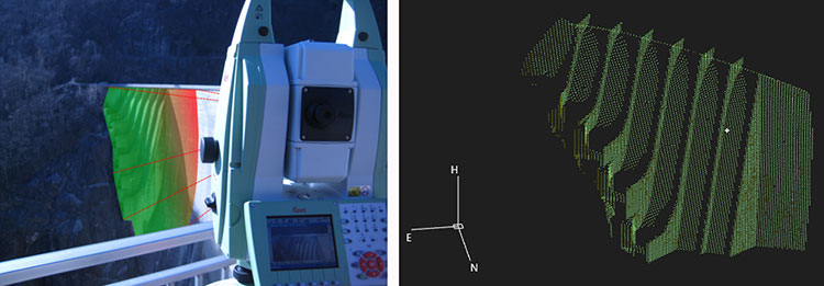
At the Razisse dam in southwest France, a Spectra Precision Focus 35 robotic total station was used to monitor structural movements during major repairs.
The Focus 35 total station on the job.
The Focus 35 monitored to a half-millimeter accuracy movement of the arch dam abutments during a critical six-week period in the project. Raising the height of the dam was expected to cause the abutments to settle, so the Focus 35 was positioned to measure XY movement to ensure they were settling properly and within expectations.
Measurements were taken at each step, with results communicated in real time to the contractor through an Excel file. The results enabled engineers to make critical decisions on whether to move further into the project. The final movement was less than a tenth of a millimeter, well within the acceptable value.
CHC has launched its new N72 GNSS series, a high-end sensor designed for GNSS applications including offshore surveys and machine control, national geodetic networks, crustal deformation monitoring and bathymetry
CHC N72 GNSS series.
The N72 GNSS series is designed to offer all necessary technical features, making it one of the most complete and reliable GNSS receivers for scientific and surveying industries professionals.
“To meet the market requirements from geodetic survey and demanding applications such as CORS, on-board machine control and disaster monitoring, CHC research and development has designed one of the most feature-rich GNSS receivers available on the market. The N72 GNSS went through extensive validation and stringent quality process to achieve high performance and reliability,” said George Zhao, CEO of CHC. “This new-generation GNSS sensor reinforces our commitment to provide complete solutions to GNSS professionals.”
N72 features top level specifications:
Embedded battery supporting 15 working hours without external power supply
32GB internal memory integrated and 1TB+ external memory supported
8 threads of logging with circulating storage and FTP push functions
Wi-Fi, LAN, Bluetooth and serial ports for data communications
LCD display and function buttons for direct configuration
Leica Geosystems has launched a new antenna for static, long-term projects requiring a high number of sensors. The Leica GMX910 can also enable dynamic monitoring with up to 10-Hz data streaming and advanced multi-frequency, multi-constellation tracking.
Starting with the basic GPS single frequency receiver and adding multiple upgradable options, this antenna fits the needs of diverse monitoring projects, the company said. The antenna supports multiple GNSS satellite systems and signals. Tracking up to 555 channels, this antenna anticipates the future and is ready for ongoing changes in GNSS technology.
The smart antenna is also fully integrated in the Leica GeoMoS deformation monitoring solution and seamlessly connects to Leica GNSS Spider offering high-quality GNSS processing results.
The highest reliability of data streaming is achieved by plugging a cable into the GMX910. An IP67 rating against dust and water, extended temperature ranges and low power consumption enables installation of the device in remote areas and severe conditions.
The Leica GMX910 adapts to a wide range of GNSS monitoring applications, from complex man-made to natural structures. The smallest movements of bridges, dams or high-rise buildings are detected in real-time.
Integration for infrastructure monitoring, navigation
By Desislava Staykova and Nico Zill
Rapid development in the technology of combined sensors within complex systems has taken place over the last decade. Such systems provide different accuracy levels, offering the possibility of use in application areas such as surveying, railway and automotive engineering, land administration, and for navigation purposes.
Multi-sensor integration and fusion is a comprehensive process of reading and combining sensor signals to ensure a higher level of data reliability and accuracy. Input data from every sensor and further combination with specially developed algorithms ensures the complete identification of observed features, which would be impossible with data from each individual sensor operating separately.
Because of its flexibility and the possibility for fast and continuous data measurement, multi-sensor integration and fusion has evolved rapidly in different areas. The object of this article is to overview the use of high-end and low-cost system complexes and software solutions for the purposes of the engineering geodesy, transportation and navigation.
Deformation Monitoring
Geodetic measurements for monitoring and displacements analysis of various engineering objects have always played an important role in maintaining structures like bridges, dam walls, building columns, wind power generators, and other construction.
This requires properly designed network schemes enabling continuous and highly accurate measurements. For such angular and length measurements of millimeter-level accuracy that must be performed in intervals of minutes, hours or a day, standard total stations are being replaced by automated ones (ATS) comprising precise servomotors, automatic target recognition sensors, electronic inclinometers, self-calibration control systems and other sensors.
The synchronized process of high-accuracy measurements (angular accuracy better than one second and distance accuracy better than one millimeter) and simultaneously adjustment software enables real-time or post-processing deformation monitoring and analysis. This type of hardware and software combination is often used during the life cycle of a project for construction and reconstruction of objects and for regular monitoring of the object’s stability.
Terrestrial Laser Scanning. The need for precise modeling and geometrical characterization of large structures and open areas as dams, mines, landslides and others cannot be covered by traditional surveying methods which require the use a huge number of points for describing the object’s surface. The development of laser scanning technology in the last decade offers a new way for deformations measurements and becomes part of the infrastructure monitoring.
The high scanning speed, dense measurement of huge numbers of points and high accuracy gives terrestrial laser scanning (TLS) an advantage other technologies used for large structural monitoring. Compared with the technologies using single point monitoring approaches where the displacements detection is limiteded to specific benchmarks, TLS provides high data redundancy. Combined with proper software products, this technique offers the possibility for high-accuracy surface modeling and displacement detection at the millimeter level. The scanned object consists of a large number of points, which allows implementation of mathematical algorithms for modeling and analyzing the object’s behavior.
Another advantage of TLS as a remote sensing measurement tool is the minimized impact of the operator over the observed points and network.
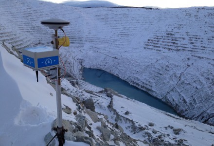
A new method for structural monitoring has emerged recently, comprising the advantages of the TLS, GNSS, geotechnical and meteo-sensors, enabling wide-area coverage and surface monitoring. One such tool is shown in Figure 1.
Figure 1. Terrestrial laser scanning combined with GNSS and other sensors enables wide-area coverage and survace monitoring. (Images courtesy of Leica Geosystems)
Mobile Laser Scanning
For different navigation purposes, for monitoring and investigation of wide areas, static measuring methods are being replaced by complex mobile measuring combinations of both high-end and low-cost sensors, to ensure fast, continuous and accurate data acquisition.
Recently mobile laser scanning (MLS) has experienced rapid development and proved its usage particularly in the railway and automotive sectors, for deformation analysis, for monitoring and documentation of as-built street and railway networks and the corresponding infrastructure objects.
MLS for Rail and Road. The advantages of MLS for fast, high-accuracy and complete scanning of the surroundings make it an important part of current railway and road conditions monitoring.
Continuous data acquisition and processing minimizes operator errors, and significantly reduces the time for performance of the surveying work and a-posteriori data analysis.
Localization and recognition of infrastructure objects forming part of railway and road environment has long been of primary importance in the transportation sector.
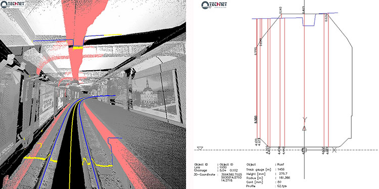
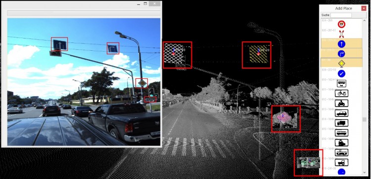
For determination and documentation of as-built railway and street networks from acquired data, Technet-Rail (Berlin, Germany) developed two software solutions, SiRailScan and SiRoadScan, for point-cloud analysis. The integrated mathematical algorithms ensure high-accuracy extraction and adjustment of the as-built left rail, right rail and center line, as well as of the roads’ border lines.
The adjusted geometry forms the basis for driving speed control tests, determination of the as-built environment for clearance detection and documentation, investigation of catenary wire deviations, ballast and road settlements, traffic signal positions, and any changes in the existing situation (see Figures 2 and 3).
Figure 2. Adjusted as-built rail geometry with SiRailScan used as basis for performance of clearance analysis and documentation in chainage based railway system.Figure 3. Adjusted with SiRoadScan road border lines. Detection and recognition of the roads signals.
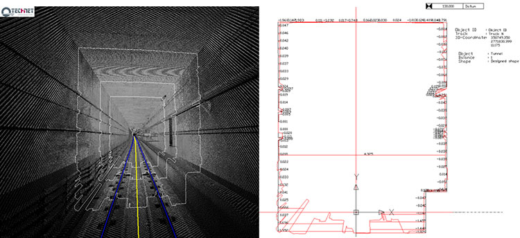
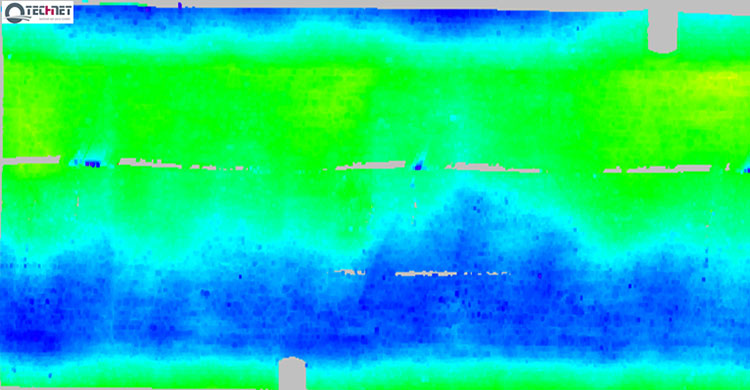
In response to the growing interest in application of the MLS technique and a-posteriori data adjustment for monitoring purposes, Technet-Rail developed additional tools for deformation analysis of structures such as tunnel bodies, railway bridges and road surfaces. The integrated software solutions enable comparison between the designed and as-built situation, epoch-wise analysis, modeling of the structure, development into 2D followed by color-coded deformation map (see Figures 4 and 5).
Figure 4. Tunnel deformation analysis performed with SiRailScan based on the as-built rail geometry. Automated calculation of differences between designed and as-built tunnel structure.Figure 5. Tunnel deformation analysis with SiRailScan based on a pre-defined form and direction.
MLS for Navigation. Multi-sensor integration is the basis for operation of the moving measuring systems integrating hardware devices such as laser scanning devices, GNSS, inertial measurement units (IMU), distance measuring instruments (DMI) and specific software algorithms for data synchronization. A milestone in the development of such systems is the measurement and navigation in indoor places or in areas with low or no GNSS coverage.
The need for safe and reliable navigation in transportation systems such as train control systems, intelligent vehicle systems, system tracking, in urban environments, underground areas, and other areas with no available GNSS signal stimulated much research in the area of multi-sensor integration and fusion. the main scope of some studies is the integration of different sensors delivering information for the attitude, velocity, acceleration such as the IMUs, inclinometers, wheel sensors, and correspondent filtering algorithms to achieve the best possible position accuracy without usage of GNSS signals.
Conclusion
For decades, infrastructure objects such as dam walls, bridges, tunnels, roads and railway tracks form a substantial part of civil engineering and engineering geodesy. The integrity of their structure requires deep knowledge of the behavior of these objects and the various methods for their optimal and high accurate monitoring. The rapid development evolution of multi sensor integration in combination with laser scanning technology makes it an essential method for accurate, continuous and dense measurement for the purposes of the engineering surveys.
Desislava Staykova and Nico Zill are engineers with Technet-rail 2010 GmbH, Berlin, Germany.
Gexcel’s 4D Inspector will be officially presented to the South American market during MundoGEO, to be held in Brazil May 5-7.
4D Inspector software can remotely manage any Focus3D laser scanner and run an automatic 3D monitoring session of buildings and infrastructures. 4D Inspector automatically transfers the scans to a remote PC where automatic deformation check runs and alarm emails can be sent to the site managers.
If required, 4D Inspector can also control a protective enclosure (ScanArmor) that can protect the Focus3D from damages.
The 4D Inspector+ScanArmor system has won the FARO Asia Pacific Product Innovation Award 2014. Designed for real-time monitoring of indoor application, 4D Inspector is has easy-to-use interface and installation procedures, according to maker Gexcel Software Solutions.
Gexcel will provide will provide an interactive demo at its booth, #187, at MundoGEO.
Newly released Leica GeoMoS 6.0 software includes automatic scanning and deformation analysis integrating the new Leica Nova MS50 MultiStation to scan areas of inaccessible manmade and natural structures. The monitoring data is also processed automatically with the new n.Vec technology implemented by Leica Geosystems. Color-coded, visualized 3D deformation clouds enable easy analysis and interpretation of movements so users can make the right decisions to rectify static problems or protect peoples’ lives.
Leica Geosystems announced version 6.0 at a media event held during the HXGN Live conference in Las Vegas today.
Leica GeoMoS Scanning is an automatic scanning solution fully integrated into Leica GeoMoS Monitoring Solution. This ensures fast integration with existing Leica GeoMoS projects and an easy start for new users, Leica said. In addition to total stations, GNSS, tilt and geotechnical sensors, highly detailed scanning can now be added to the automated measurement cycle. The new scanning module is easy to configure and provides the complete workflow for automatic acquisition and processing of the data to visualize deformations and to notify key personnel in the case of an event. With Leica GeoMoS Web, the data can be accessed anywhere at any time. Leica GeoMoS 6.0 enhances conventional monitoring methods with automatic scanning of surfaces with the Leica Nova MS50 MultiStation. Used for inaccessible places or locations where prisms cannot be installed, e.g. a road cover, a roof, a pipeline or a natural structure, Leica GeoMoS real-time scanning solution monitors any deformation and makes sure that no movement is undetected. The big advantage of using the Leica Nova MS50 MultiStation is that it combines laser scanning and prism monitoring, and therefore the measurements to stable control points guarantee highly accurate setup corrections, including orientation and translations. Additional imaging functionality complements the set by providing yet another information source for better deformation analysis. The implemented scan wizard allows the image-assisted definition of scan areas using different parameter settings and different scan result types. Once defined, the scan area can be scanned manually and via the automatic measurement cycle.
Leica GeoMoS 6.0 enhances conventional monitoring methods with automatic scanning of surfaces with the Leica Nova MS50 MultiStation.
The new scanning feature uses all current automatic functionalities such as automatic measurement cycle scheduling, real-time notification via e.g. SMS/email, automatic limit level check, etc. In addition, the embedded point cloud and image viewer assures powerful 3D visualization of all results using color-coded deformation clouds with a fully traceable history of deformations of the scanned area.
The new n.Vec technology in Leica GeoMoS 6.0 provides automatic scan cloud processing to deliver the real-time information about deformations. The data can quickly and easily be interpreted for informed decisions. Leica Geosystems’ unique n.Vec processing technology uses normal vectors to determine movements in man-made and natural structures through color-coded deformation maps. The deformation maps are created by comparing normal vectors from a reference epoch and the current epoch. To ensure maximum deformation interpretation quality, in an iterative and fully automatic procedure, n.Vec removes non-surface related scan artifacts to ensure uncontaminated surfaces and hence correct normal vectors.