Tag: Delft University of Technology

  • Researchers develop 10-cm accuracy navigation system

    Researchers develop 10-cm accuracy navigation system

    Researchers at Delft University of Technology, Vrije Universiteit Amsterdam and VSL have developed an alternative positioning system that is more robust and accurate than GPS, especially in urban settings.

    The aim of the project — SuperGPS — was to develop an alternative positioning system that makes use of the mobile telecommunication network instead of satellites and that has better accuracy than GPS.

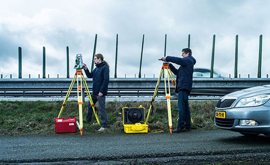
    The working prototype that demonstrated this new mobile network infrastructure achieved an accuracy of 10 centimeters.

    The new technology is important for the implementation of a range of location-based applications, including automated vehicles, quantum communication and next-generation mobile communication systems.

    Much of our vital infrastructure relies on GNSS. Yet systems that rely on satellites have limitations and vulnerabilities. For instance, their radio signals are weak when received on Earth, making accurate positioning no longer possible if the radio signals are reflected or blocked by buildings.

    “We realized that with a few cutting-edge innovations, the telecommunication network could be transformed into a very accurate alternative positioning system that is independent of GPS,” said Jeroen Koelemeij of Vrije Universiteit Amsterdam. “We have succeeded and have successfully developed a system that can provide connectivity just like existing mobile and Wi-Fi networks do, as well as accurate positioning and time distribution like GPS.”

    Photo: Delft University of Technology
    Illustration: TU Delft / Stephan Timmers

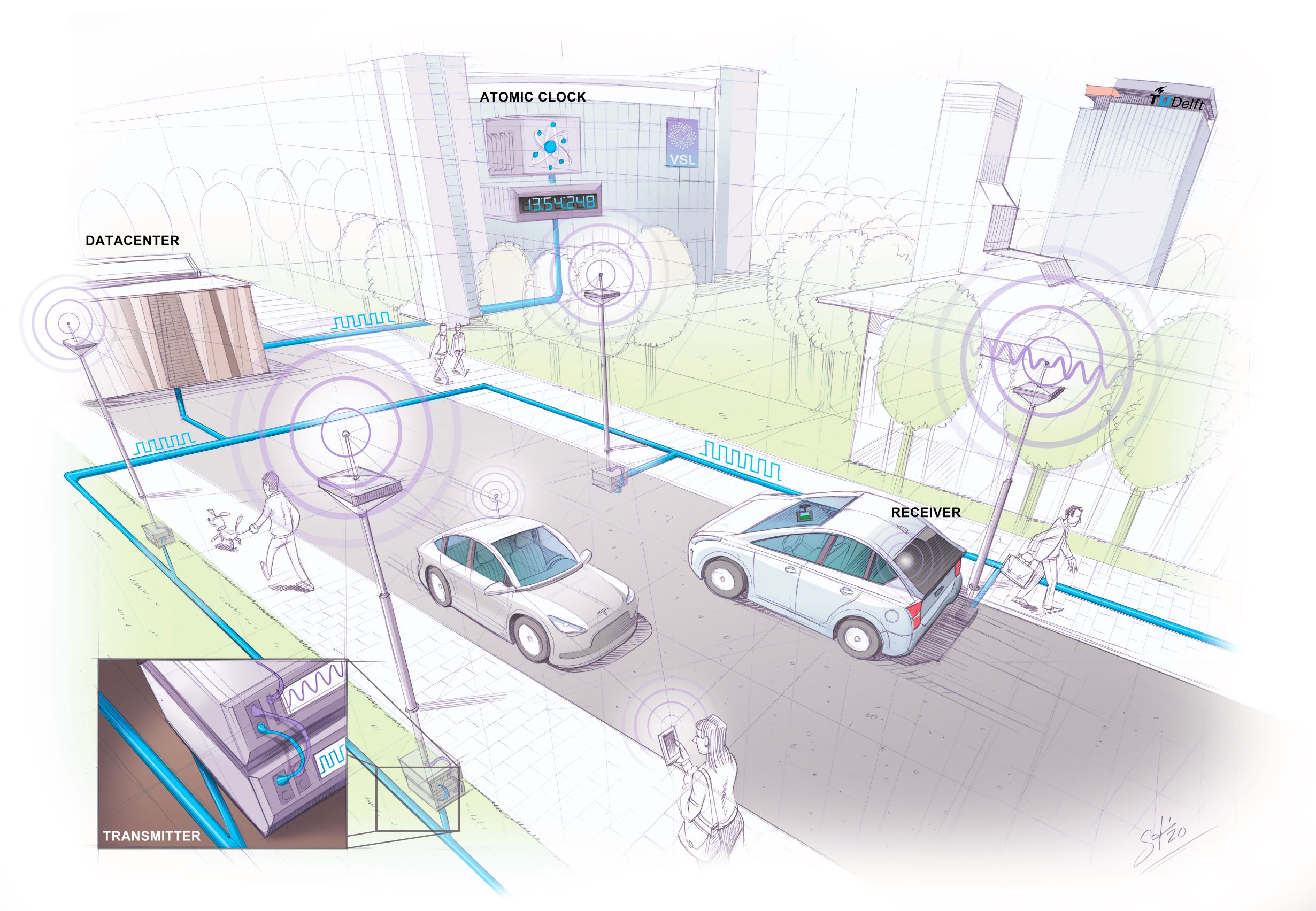
    One innovation is to connect the mobile network to a very accurate atomic clock so that it can broadcast perfectly timed messages for positioning, just like GPS satellites do with the help of the atomic clocks they carry on board. These connections are made through the existing fiber-optic network.

    “With these techniques, we can turn the network into a nationwide distributed atomic clock — with many new applications such as very accurate positioning through mobile networks,” said Erik Dierikx, VSL. “With the hybrid optical-wireless system that we have demonstrated now, in principle anyone can have wireless access to the national time produced at VSL. It basically forms an extremely accurate radio clock that is good to one billionth of a second.”

    The system also employs radio signals with a bandwidth much larger than commonly used. “Buildings reflect radio signals, which can confuse navigation devices. The large bandwidth of our system helps sorting out these confusing signal reflections, and enables higher positioning accuracy,” explained Gerard Janssen of Delft University of Technology. “At the same time, bandwidth within the radio spectrum is scarce and therefore expensive. We circumvent this by using a number of related small bandwidth radio signals spread over a large virtual bandwidth. This has the advantage that only a small fraction of the virtual bandwidth is actually used and the signals can be very similar to those of mobile phones.”

    The results of the peer-reviewed research have been published in Nature.

    Photo: TU Delft / Frank Auperlé
    Photo: TU Delft / Frank Auperlé
  • New surveying and mapping textbook available for download

    New surveying and mapping textbook available for download

    A new surveying and mapping textbook is now available on the OPEN Textbook network.

    book coverWritten in English, the book provides an academic introduction to the field of surveying and mapping. It is based on handouts and readers written for the third-year course “Surveying and Mapping” in the civil engineering bachelor’s program at Delft University of Technology in The Netherlands.

    The textbook covers a wide range of measurement techniques, from land surveying using GPS/GNSS and remote sensing to the associated data processing, the underlying coordinate reference systems, and the analysis and visualization of the acquired geospatial information.

    Although a few parts of the book are specific to The Netherlands, for the most part the material is applicable globally.

    Surveying and Mapping

    Authors: Christian Tiberius, Hans van der Marel, René Reudink and Freek van Leijen / Delft University of Technology / The Netherlands

    ISBN (softback/paperback): 9789463664905

    ISBN (ebook): 9789463664899

    DOI: https://doi.org/10.5074/T.2021.007

    The book is freely available as an OPEN Textbook by the TU Delft library.

  • Seen & Heard: Greenhouse pest drone, COVID-19 vaccination drop

    Seen & Heard: Greenhouse pest drone, COVID-19 vaccination drop

    “Seen & Heard” is a monthly feature of GPS World magazine, traveling the world to capture interesting and unusual news stories involving the GNSS/PNT industry.


    Screenshot: PATS Indoor Drone Solutions video
    Screenshot: PATS Indoor Drone Solutions video

    Seeking out (tiny) aerial threats

    Palm-sized drones are eliminating greenhouse pests in the Netherlands, reports the Associated Press. The drones seek out and destroy moths that produce crop-eating caterpillars. Tech startup PATS Indoor Drone Solutions uses drones as greenhouse sentinels. Cameras scan the airspace, and then steer the drones to fly into moths, destroying them in midair. The drone control system can distinguish between good and bad insects. The system is the brainchild of former students from the Delft University of Technology.


    Photo: Skydio
    Photo: Skydio

    Coming soon to a police department near you

    Drone-maker Skydio claims to be shipping the most advanced artificial intelligence-powered drone ever built, reports Forbes. The Skydio X2 is scheduled to launch later this year. The quadcopter reportedly can latch onto targets and follow them, dodging all sorts of obstacles and capturing everything on high-quality video. It can fly in tight, tactical situations, such as inside buildings or through a forest. Skydio claims its software can even predict a target’s next move, whether pedestrian or vehicle. American-made, the Skydio is popular with police departments and is often used for defense.


    The Loyal Wingman in its first test flight. (Photo: U.S. Air Force 88th Air Wing Public Affairs)
    The Loyal Wingman in its first test flight. (Photo: U.S. Air Force 88th Air Wing Public Affairs)

    Fighter jets to get a sidekick

    A military drone that will accompany fighter jets into combat flew its maiden voyage at the end of February. The Loyal Wingman, designed by Boeing Australia for the Royal Australian Air Force (RAAF), uses artificial intelligence to target enemies. The Loyal Wingman is about the same size as the F-35 jet it will fly alongside. It has a range of 3,700 kilometers. The plane was flown from the ground control station at the Woomera Range Complex in the outback. The RAAF plans to buy three of the drones.


    Photo: Zipline
    Photo: Zipline

    COVID-19 vaccinations air-dropped in Ghana

    Ghana has launched a nationwide program that uses Zipline drones to deliver coronavirus vaccines to rural communities. Deliveries began March 2 under the COVAX program of the World Health Organization (WHO), which aims to provide poorer countries with enough doses to cover 20% of their populations. Zipline has been delivering medical supplies (blood, personal protective equipment, vaccines) since 2016 using its patented, autonomous drones.