The Indian Institute of Technology (IIT) Roorkee is offering a free online course on GNSS and Applications on the NPTEL platform. The four-week course will provide a basic understanding about digital elevation models (DEMs) and their applications in civil engineering and Earth sciences.
During the course, various DEMs and their sources, generation techniques, derivatives, errors and limitations will be discussed extensively. Surface hydrologic modeling using DEMs, modeling derivatives and their applications will also be discussed.
Intended audience. Under- and post-graduate engineering and post-graduate science students and faculty.
Pre-requisites. Current students of engineering, post-graduate science students and Ph.D. students should have basic knowledge of geographic information systems (GIS) and remote sensing.
Industry support. Geoinformatics companies (such as NIIT, Esri India, Leica Geoinformatics, MapmyIndia, ISRO and more).
The course will be taught by Arun K. Saraf, professor in the Department of Earth Sciences at IIT Roorkee. He teaches courses on remote sensing, digital image processing, GIS, advanced GIS, geomorphology and related topics to undergraduate and postgraduate students of Geological Technology and Applied Geology. He has a Ph.D. in remote sensing from the University of Dundee, United Kingdom.
The course takes place July 26-August 20. Registration is open until August 2 and can be done through the SWAYAM platform.
RedTail Lidar Systems partnered with an engineering firm to demonstrate the RTL-400 lidar system’s high-resolution, high-accuracy mapping capability.
Cross-section of lidar point cloud (Image: RedTail Lidar Systems)
According to the company, its lidar imagery was used to generate as-built conditions of a steep ravine to aid in long-term monitoring of the slopes under which a natural gas pipeline was buried.
A narrow road traversing the top of the ravine through which the pipeline was installed was of concern since the instability could be dangerous. Loss of vegetation along the buried pipeline’s path also makes the area especially susceptible to slides after heavy rainfall.
Top view of lidar point cloud (Image: RedTail Lidar Systems)
The RTL-400’s high-resolution point cloud data of the 13-acre ravine area was captured in 10 minutes, RedTail Lidar Systems said. The as-built digital elevation model (DEM) created from the lidar point cloud can be compared to future DEMs to determine if any changes have occurred in the slope’s topology, which would serve to identify hazards and provide input for slip mitigation.
RedTail Lidar Systems is a division of 4D Tech Solutions, a company focused on providing innovative technology-based solutions to address government and commercial customer needs.
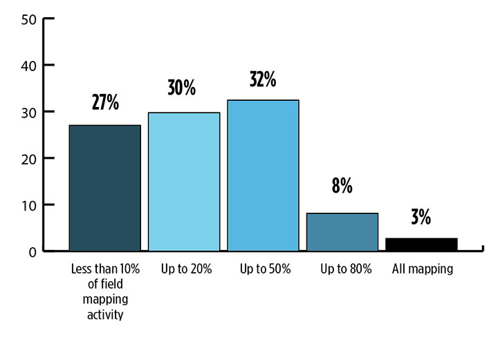
While UAVs are an exciting new technology for mapping, most respondents to our survey recognize the continued value of hands-on, in-the-field data collection.
Most respondents think UAVs could be used for as much as half of data collection, but very few expect UAVs to be used for more than that. UAVs are just one mobile collection method, of course. Others include autos such as SUVs, boats and all-terrain vehicles.
What role will UAVs play in the mapping industry over the next three years? (Source: GPS World 2018 State of the GNSS Industry survey)
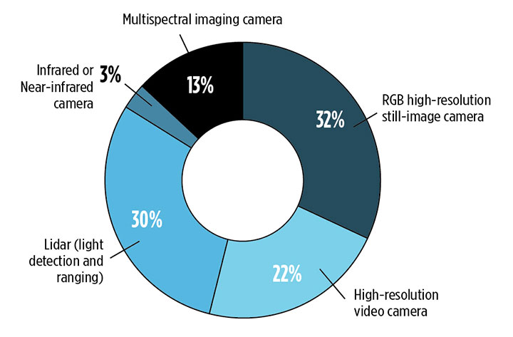
We also asked respondents how they use UAVs for data collection. RGB high-resolution still-image cameras and lidar are the most frequently used, with video cameras not far behind. Other specialty cameras collect infrared or thermal imagery, while specialty sensors collect everything from temperature to pressure and methane levels.
Whether mounted on a UAV, a vehicle, or on the ground, these technologies are used in fields as diverse as forest management, disaster response and infrastructure planning.
For instance, urban planners rely on mapping data for land value, topography and water and electricity resources. Meanwhile, forestry experts use infrared to detect areas of disease or die-off in the early stages.
Software in the Cloud. Turning to software, developments in cloud storage and open-source and subscription platforms are constantly improving geographic information systems (GIS). A wealth of GIS and GPS data is available from Google Maps, Apple Maps, OpenStreetMap and other applications. Specialty applications include Esri ArcGIS, Maptitude, Surfer and more. In the coming years, expect an increase in 3D modeling, digital elevation models (DEMs) and augmented reality.
What is the most valuable sensor to use in conjunction with GPS/GNSS aboard a UAV for mapping and data-collection purposes? What role will UAVs play in the mapping industry over the next three years? (Source: GPS World 2018 State of the GNSS Industry survey)
The automotive sector has been adopting digital mapping applications for use in self-driving cars, as well as fleet management, logistics control systems, and advanced driver assistance systems (ADAS).
Every year, more satellites are launched for mapping and GIS data collection, and they don’t all provide photo imagery. For instance, NASA’s Aqua satellite detected and mapped huge concentrations of carbon monoxide drifting east across the U.S. from western wildfires — important information for public health planning.
For more results from the 2018 State of the GNSS Industry, see this page.
Esri is releasing Sentinel-2 Image Services to all Esri users for no additional cost.
According to the company, Sentinel-2 is an Earth Observation Satellite that provides multi-spectral imagery for any location in the world at 10-meter resolution. Currently in beta, the service is updated daily with new imagery for all ground locations every five to seven days.
The Sentinel-2 Image Services provide temporal, multi-spectral imagery of the entire globe for improved monitoring of agricultural and forest conditions, monitoring of land cover changes, and to assist with natural disaster management.
Sentinel-2 is part of Copernicus, the world’s largest single Earth observation program directed by the European Commission in partnership with the European Space Agency.
Esri makes the multi-spectral data quickly accessible using ArcGIS Image Server and publishes an image service through the ArcGIS Living Atlas of the World, hosted on the Amazon Web Services Infrastructure.
The service includes all Sentinel-2 imagery going back 14 months, enabling change to be easily reviewed. Image analysis can be run directly on the service to create indexes displaying properties such as vegetation health or soil moisture as well as quantifying the changes over time, for better understanding of the environment.
“We are committed to helping our users discover, explore, and better understand our changing planet,” said Jack Dangermond, Esri founder and president. “Pairing Sentinel-2 imagery with our ArcGIS Image Server provides a powerful platform for in-depth analysis which can inform meaningful action.”
Sentinel-2 multi-spectral imagery can provide better visualization and understanding of catastrophic events such as Hawaii’s Kilauea volcano, the company said. The ability to use imagery of the volcano along with other spatial data, such as digital elevation models, provides an unprecedented opportunity to help predict lava flow direction and provide advanced notice to those who may be in danger.
Sentinel-2 can also help provide understanding of the conditions that lead to fires such as this past winter’s Thomas Fire, which is California’s largest wildfire on record. The Thomas Fire burned more than 280,000 acres and triggered massive mudslides. Visualizing factors, such as periods of increased moisture contributing to more lush vegetation followed by hot and dry weather, can help predict future wildfires and mitigate their effects in the future.
The Sentinel-2 imagery is available through the Living Atlas, the foremost collection of geographic information from around the globe. The Living Atlas is included with all ArcGIS online subscriptions. It is comprised of maps, apps, and data layers that support the work of thousands of Esri users around the world. Full service access, including a rolling 14-month archive of the Sentinel-2 data, is now available to all Esri ArcGIS users.
Drone-maker 3DR is teaming up with Esri to integrate 3DR’s Site Scan software with Esri Drone2Map.
3DR made the announcement at the Esri User Conference, held last week in San Diego.
Designed for the field professional, Site Scan is an intuitive, powerful and open aerial data capture and analytics platform that delivers an end-to-end solution ready-made for existing mapping and survey workflows, 3DR said in a news release. With Site Scan and Drone2Map, Esri customers can safely, quickly and easily conduct surveys with the Solo smart drone and effortlessly deliver that data to ArcGIS and ArcGIS Online.
“Aerial data capture technology is bringing about a revolution in surveying and mapping,” said Lawrie Jordan, Director of Imaging and Remote Sensing at Esri. “We are thrilled to partner with 3DR to streamline the creation of professional imagery products with Site Scan and Drone2Map for ArcGIS. Together we will accelerate the development and use of remote sensing across all industries.”
Site Scan automatically calculates a flight plan and Solo autonomously executes both flight and image capture. Images are processed and integrated with Esri Drone2Map to create high-resolution georeferenced maps and digital elevation models to share as tile or feature services in ArcGIS and ArcGIS Online.
“Capturing site data today is costly, time consuming and often dangerous. Drones can easily go where it’s inefficient or unsafe for field personnel, making it easier to accurately measure our world so we can better analyze and manage it,” said Chris Anderson, CEO of 3DR. “We’re delighted to partner with such a great industry leader and integrate Site Scan with Esri Drone2Map. Together, we offer a complete solution for site capture that will help our customers create maps that tell stories, record change over time and perform analysis all while saving time, saving money and keeping humans out of harm’s way.”
Site Scan makes it safer and easier than ever for people in land management, GIS, mapping, energy, infrastructure and related fields to aggregate and process multiple forms of aerial imagery and data and easily incorporate them into the Esri tools they use every day, 3DR said.
Engineering and survey firm McKim & Creed, based in Fort Worth, Texas, is one customer. “Utilizing the 3DR Solo and SiteScan allowed McKim & Creed to confidently collect accurate spatial information in dangerous and demanding environments where it would have been difficult to use traditional survey methods,” said Christian Stallings, R&D Manager at McKim & Creed.
“Using Esri’s Drone2Map software, surveyed ground control and 3DR’s Solo, we were able to collect detailed elevation information and high-resolution orthophotography over a dredging containment pond operated by the United States Army Corps of Engineers (USACE). This approach proved to be accurate and kept people out of harm’s way — which would only be achievable using this approach,” Stallings said.
3DR designed Site Scan as an open and extensible platform. On the hardware side, the Solo smart drone has open gimbal and accessory bays, which give both 3DR and their global technology partners the ability to integrate additional cameras and sensors.
Additionally, Solo firmware updates optimize the drone’s flight profile and performance. On the software side, 3DR continually updates the Site Scan application so that customers can take advantage of the most recent and advanced analytics technologies.
With Site Scan, even users new to drone technology will fly with confidence from day one. The Site Scan app includes 3DR’s airspace safety information software, which alerts users if they’re about to fly in restricted airspace. They can then pull up a map of the area with all restrictions around them clearly marked.
To support enterprise customers further, 3DR offers Success Services, including the Premier Success Plan. Included with their purchase of Success Services, all Site Scan users will have access to experts on Site Scan and Solo. They will also have a Solo overnight replacement guarantee should anything go wrong with one of their drones.
Site Scan with Solo Enterprise is available immediately for order on store.3dr.com, priced at $3249 with a monthly service fee of $499 paid annually with a 12-month commitment.
Today at the Esri User Conference, 3DR announced that it has teamed up with Esri to integrate 3DR’s Site Scan with Esri Drone2Map.
Designed for the field professional, Site Scan is an intuitive, powerful and open aerial data capture and analytics platform that delivers an end-to-end solution ready-made for existing mapping and survey workflows, 3DR said in a news release. With Site Scan and Drone2Map, Esri customers can safely, quickly and easily conduct surveys with the Solo smart drone and effortlessly deliver that data to ArcGIS and ArcGIS Online.
“Aerial data capture technology is bringing about a revolution in surveying and mapping,” said Lawrie Jordan, Director of Imaging and Remote Sensing at Esri. “We are thrilled to partner with 3DR to streamline the creation of professional imagery products with Site Scan and Drone2Map for ArcGIS. Together we will accelerate the development and use of remote sensing across all industries.”
Site Scan automatically calculates a flight plan and Solo autonomously executes both flight and image capture. Images are processed and integrated with Esri Drone2Map to create high-resolution georeferenced maps and digital elevation models to share as tile or feature services in ArcGIS and ArcGIS Online.
“Capturing site data today is costly, time consuming and often dangerous. Drones can easily go where it’s inefficient or unsafe for field personnel, making it easier to accurately measure our world so we can better analyze and manage it,” said Chris Anderson, CEO of 3DR. “We’re delighted to partner with such a great industry leader and integrate Site Scan with Esri Drone2Map. Together, we offer a complete solution for site capture that will help our customers create maps that tell stories, record change over time and perform analysis all while saving time, saving money and keeping humans out of harm’s way.”
Site Scan makes it safer and easier than ever for people in land management, GIS, mapping, energy, infrastructure and related fields to aggregate and process multiple forms of aerial imagery and data and easily incorporate them into the Esri tools they use every day, 3DR said.
Engineering and survey firm McKim & Creed, based in Fort Worth, Texas, is one customer. “Utilizing the 3DR Solo and SiteScan allowed McKim & Creed to confidently collect accurate spatial information in dangerous and demanding environments where it would have been difficult to use traditional survey methods,” said Christian Stallings, R&D Manager at McKim & Creed.
“Using Esri’s Drone2Map software, surveyed ground control and 3DR’s Solo, we were able to collect detailed elevation information and high-resolution orthophotography over a dredging containment pond operated by the United States Army Corps of Engineers (USACE). This approach proved to be accurate and kept people out of harm’s way — which would only be achievable using this approach,” Stallings said.
3DR designed Site Scan as an open and extensible platform. On the hardware side, the Solo smart drone has open gimbal and accessory bays, which give both 3DR and their global technology partners the ability to integrate additional cameras and sensors.
Additionally, Solo firmware updates optimize the drone’s flight profile and performance. On the software side, 3DR continually updates the Site Scan application so that customers can take advantage of the most recent and advanced analytics technologies.
With Site Scan, even users new to drone technology will fly with confidence from day one. The Site Scan app includes 3DR’s airspace safety information software, which alerts users if they’re about to fly in restricted airspace. They can then pull up a map of the area with all restrictions around them clearly marked.
To support enterprise customers further, 3DR offers Success Services, including the Premier Success Plan. Included with their purchase of Success Services, all Site Scan users will have access to experts on Site Scan and Solo. They will also have a Solo overnight replacement guarantee should anything go wrong with one of their drones.
Site Scan with Solo Enterprise is available immediately for order on store.3dr.com, priced at $3249 with a monthly service fee of $499 paid annually with a 12-month commitment.
Icaros Inc., a provider of aerial remote sensing services and software, has announced that Harris Geospatial Solutions, a division of Harris Corporation, will offer the Icaros OneButton family of image processing software as a front-end complement to its ENVI geospatial analytics solution for users extracting information from manned and unmanned aerial sensor data.
“Together, OneButton and ENVI create a complete image processing and analytics workflow for aerial image data,” said Tom Bosanko, Icaros CEO. “Both packages are highly customizable to meet the needs of specific vertical market applications.”
Icaros developed the OneButton family for geospatial end users to easily and automatically generate precise, fully orthorectified 2D maps and 3D models from frame-based aerial imaging systems. Originally engineered for manned aircraft sensors, the OneButton software has been modified to accommodate the collection conditions of unmanned aerial systems (UAS).
“The combination of OneButton and ENVI provide best-of-breed, application-specific image processing and analytics, that enable customers to solve challenging problems related to everything from agriculture and forestry to utilities and city planning,” said Beau Legeer of Harris Geospatial Solutions.
OneButton automatically processes raw raster imagery with onboard GPS/IMU data to stitch the individual scenes together into a seamless, color-balanced orthomosaic meeting photogrammetric standards.
Outputs include digital elevation models (DEMs), true color 3D point clouds, multispectral mosaics and controlled oblique imagery — all ready for ingest directly into the ENVI software environment.
OneButton comes in both Standard and Professional versions. The Standard package asks the end user to specify the application and terrain type for the project at hand. The software then intuitively sets parameters of the photogrammetric engine to perform the mosaicking to the level of precision required. For example, the processing algorithms would handle flat agricultural fields different from a rolling urban landscape.
“The Professional version is more customizable, allowing end users to adjust the processing parameters themselves based on the precision they need, and then edit the resulting mosaic to remove anomalies, like an airplane moving down a runway. OneButton Professional was specifically designed to generate results with the efficiency and accuracy necessary for large scale projects and survey-quality results,” Bosanko said.
OneButton is platform and sensor agnostic, and processes raster image data from small-, medium-, and large-format frame sensors capable of capturing visible RBG, multispectral, near-infrared and thermal infrared data.
The OneButton solution for ENVI is available now to existing and new customers, and both companies expect further technology integration in the near future around cloud enablement of the UAS data processing and analytics workflow.
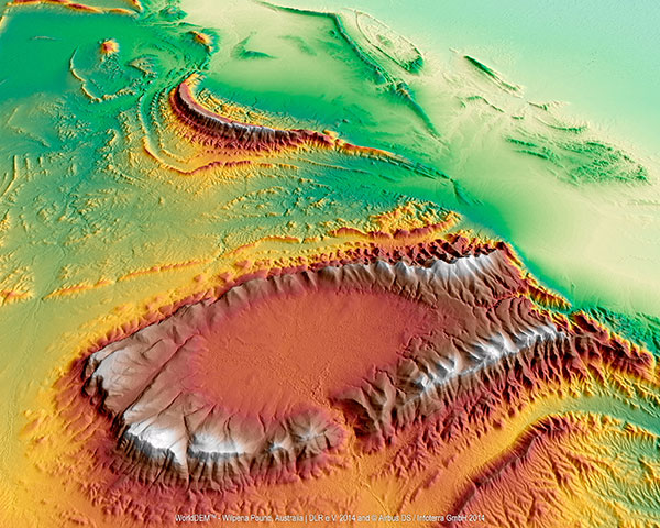
(WorldDEM image courtesy of Airbus Space & Defence)
Wilpena Pound, shown above, is a natural amphitheater of mountains in the heart of Flinders Ranges National Park in South Australia. Wilpena Pound is 17 kilometers long and 8 kilometers wide, covering an area of 100 kilometers. The highest peak is St. Mary Peak, at 1,170 meters.
The WorldDEM Digital Elevation Model of the Pound is based on data acquired by the German high-resolution radar satellites TerraSAR-X and TanDEM-X, which started synchronous data acquisition in December 2010 and completed coverage of the Earth’s entire landmass twice over in mid-2013. The satellites covered more complex terrain areas with a third and fourth acquisition campaign to ensure accuracy for the WorldDEM mapping database, a 3D global pole-to-pole digital elevation model distributed by Airbus Defence and Space.
Since its commercial launch in April 2014, WorldDEM has provided high-precision elevation models to a wide variety of industries. Mining studies in equatorial regions use it to analyze dense vegetation. It’s used for infrastructure corridor design and costing. Military and civil aviation use it for low-altitude flight path and landing-area planning for helicopters and aircraft in remote and difficult to access areas.
The database now covers large parts of North and South America, Western and Southern Africa, the Middle East, Australia, Northern Europe and Asia. The most recent additions include complete coverage of Scandinavia, Ukraine, Iran, Iraq, Angola and Saudi Arabia. In all, 80 million km² of WorldDEM data has been captured.