Intergeo 2020, originally slated to take place Oct. 13-15 in Berlin, Germany, will now take place entirely virtually. Organizers announced in early June that the show would take place partially in person and partially virtually.
“Due to international travel restrictions, the protection of risk groups and the limited possibilities of people coming together in enclosed spaces, the Intergeo 2020 in its diversity and size is not feasible under the usual circumstances,” organizers said in an email to registrants.
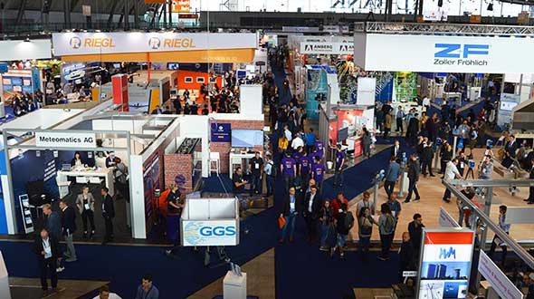
Berlin recently reduced the number of participants of indoor events to 1,000 people, making the show — which attracted more than 20,000 participants in 2019 — unfeasible.
Now called INTERGEO 2020 Digital, the conference will facilitate the transfer of knowledge and exchange of ideas as well as providing “accessibility and opportunity to drop in at the exhibitors.”
The 2020 Intergeo trade show will be hosted both in-person and virtually, said Intergeo organizer Christoph Hinte. The theme of the 2020 event will be “Geoinformation for a smarter world.”
“The hygiene and social distancing concept is currently being coordinated,” Hinte said. “In addition to the live event, this year is the first time we will also offer a virtual twin. Both the conference and the fair will be replicated. By hosting the fair in a virtual format, we expect to attract the same number of visitors as in previous years, if not more.”
Hinte made this announcement at the Intergeo Roundtable, an annual mid-year event for experts to discuss the latest industry trends.
During the roundtable, attendees discussed the latest industry trends. One trend mentioned in particular is the advancement of digitalization because of the COVID-19 pandemic. Trimble’s Janos Faust noticed that attitudes towards digitalization changed overnight after the breakout of the coronavirus pandemic, with people taking the digital transformation more seriously. Hexagon’s Michael Mudra also pointed out that anyone with round-the-clock access to automatically recorded, up-to-date and networked data that is evaluated using AI now has a clear advantage. Finally, Autodesk’s Ralf Mosler pointed out that companies are rapidly moving away from traditional work models and turning to technologies that completely reconnect BIM and GIS workflows.
Attendees also emphasized how the geo-IT industry can make a significant contribution to the climate crisis and current lack of resources. With regard to fleet management, up to 20% less fuel is being used and in Germany alone, precision farming methods are resulting in efficiency gains of 30%, Intergeo said in a press release. Whether it’s greater energy efficiency, enhanced energy utilization or even the simulation of different building methods, attendees agreed the industry is having a noticeable societal impact in both raw materials extraction and construction planning, Intergeo added.
New Matrice 300 RTK and Zenmuse H20 series cameras ready for new generation of work, including digitalization and artificial intelligence (AI)
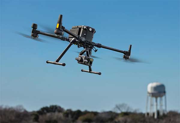
DJI has unveiled its most advanced commercial drone platform, the Matrice 300 RTK (M300 RTK), along with the Zenmuse H20 Series, a hybrid, multi-sensor camera.
The Matrice 300 RTK UAV from DJI is designed for the next level in data collection and site inspection. (Photo: DJI)
DJI engineered the all-in-one, high-tech solution for areas of work never explored before in precise aerial inspections and data-collection missions.
“With the M300 RTK flying platform and the Zenmuse H20 camera series, we are providing a safer and smarter solution to our enterprise customers” said Christina Zhang, senior director, Corporate Strategy at DJI. “This solution sets an entirely new standard for industrial UAV solutions, significantly enhancing operations across public safety, law enforcement, energy, surveying and mapping as well as critical infrastructure inspections.”
The M300 RTK is the first DJI product that integrates modern aviation features, advanced AI capabilities, six directional sensing and positioning system, a UAV health management system, and 55 minutes’ flight time.
The drone platform has AES-256 encryption and an IP45 weather-resistant enclosure. It has a built-in all-new OcuSync Enterprise transmission system that provides a triple-channel 1080p video transmission signal reaching up to 15 km away.
The M300 RTK can support up to 3 payloads simultaneously and has a maximum payload capability of up to 2.7 kg.
“For our teams working in the oil & gas industry, performance and safety are not optional,” said customer Adam Serblowski, Robotics Theme Lead at Shell. “We cannot compromise on our pursuit of utilizing the best and most efficient tools available. The DJI Matrice 300 RTK proves to be an ideal upgrade over the existing DJI product line, and it helps us to further enhance the benefits of our drone programs. Our productive partnership with DJI will continue to help elevate safety in the world’s largest industry.”
With the Zenmuse H20 Series Camera
Combined, the M300 RTK and Zenmuse H20 Series solution offers users two intelligent ways to collect data:
Smart Pin & Track. Intelligent functions that enhance synchronization of aerial intelligence in coordinated missions. It includes PinPoint, a function that allows users to mark the subject of interest and instantly share the precise location data to a second operator or if necessary to ground teams via DJI FlightHub; and Smart Track, which allows users to automatically detect and track a moving object, even at extreme distances, while synchronising the subject’s dynamic location in real time.
Smart Inspection. A new set of features developed to optimize routine data collection missions such as power lines, railway and oil and gas inspections. It consists of Live Mission Recording for recording sample automated missions in real time; AI-Spot Check, which enables data collection from exactly the same location every time, greatly improving the accuracy of automated missions. After photos from a sample waypoint inspection mission have been recorded, operators are able to mark the subject of interest. During subsequent automated flight missions, AI algorithms perform a comparison between the marked subject and current live view, thus correcting the camera orientation accordingly to deliver accurate and consistent results; and Waypoints 2.0 — an improved mission planning system offering up to 65,535 waypoints, while supporting an array of consecutive actions, 3rd party payloads, and more.
Aviation-Grade Situational Awareness. Inspired by today’s modern aircraft, the M300 RTK features a Primary Flight Display (PFD) that merges real-time flight and navigation data into one integrated display. Besides standard telemetry data like altitude and speed, the M300 RTK PFD provides obstacle data for visualising nearby obstacles during flight, enabling pilots to adjust flight trajectory if needed. These enhancements allow users to keep track of the aircraft while further enhancing the pilot’s situational awareness.
Dual-operator mode. New to DJI’s commercial drone platforms and exclusive to the M300 RTK, is Advanced Dual Operator Mode – multi-pilot control protocols that enable the execution of missions with enhanced safety, reliability and flexibility.
The M300 RTK, when controlled by two pilots, gives each pilot equal access to gain flight-control priority, the transfer of which is displayed by a series of icons on the DJI Smart Controller Enterprise. If one pilot becomes compromised or their controller loses battery or connection, the other pilot gains full control over the M300 RTK and its payloads.
When training new pilots, the teacher/main pilot can safely take over flight control if necessary.
Improved safety and reliability
The M300 RTK comes with new and improved safety and reliability enhancements, including:
AES-256 Encryption: for secure data transmission of the command & control uplink and video transmission downlink.
AirSense (ADS-B technology): for enhanced airspace safety.
Anti-Collision Beacon: for increased aircraft visibility, especially in low-light conditions.
IP45 Protection Rating & Self-Heating Battery: for adverse weather conditions (-20 to 50° C).
6 Directional Sensing and Positioning System: offers a maximum detection range of up to 40 m horizontally, with options to customize the aircraft sensing behavior via DJI Pilot.
As with modern-day jetliners, the M300 RTK offers an integrated UAV Health Management System (UHMS) to optimize fleet maintenance. It records the aircraft’s flight data throughout its entire lifecycle, and utilizes the drone’s hardware and software systems to understand current aircraft performance and determine when it should be serviced. Taking advantage of this new system, users can get a quick overview of all critical aircraft systems, manage firmware updates across an entire fleet, track pilot hours and review flight missions.
DJI Zenmuse H20 Series
The new camera payloads are designed to improve mission efficiency. The Zenmuse H20 series offers DJI’s first Hybrid multi-sensor solution, allowing capture of any kind of images for industrial applications and public-safety missions where efficient time management and immediate access to multiple layers of visions are paramount.
The H20 Series is IP44 rated, which protects enclosures from splashes of water from any direction.
The H20 series comes in two versions:
The H20, a triple sensor with a 20-MP, 23x hybrid optical zoom camera, a 12-MP wide camera, and a laser range finder covering distances from 3 to 1200 meters
The H20T, a quad sensor that adds a 640 x 512 radiometric thermal camera, allowing operators to see what is invisible to the human eye using high thermal sensitivity at 30 frames per second video definition.
Integrated user interface
To enable pilots to operate so many sensors at once, the accompanying DJI Pilot app interface was redesigned. The new user interface lets pilots quickly switch between cameras and simplifies the process of zooming in and out by letting pilots preview the zoom field of view on top of the wide angle or thermal camera footage.
With a multi-sensor integrated user interface, the Zenmuse H20 series allows users to smoothly switch between wide, zoom or thermal cameras. It also includes features for maximum flexibility when used on time-sensitive missions.
High-Res Grid Photo: Captures in one snap detailed imagery of defined subjects with the help of a custom grid. The images can be stored for later detailed inspection.
One-Click Capture: Captures videos or photos of up to three cameras simultaneously without having to manually switch between camera views or repeat a mission.
Night Scene: Gains clearer visibility when lighting conditions are not optimal.
The M300 RTK and Zenmuse H20 series are available for pre-order from official DJI Enterprise dealers and will start shipping in Q2 2020.
Intergeo 2019, which is set to take place Sept. 17-19 in Stuttgart, Germany, will cover a number of key geodata topics. The main topics highlighted during the conference will include smart cities, campus geoinnovation, digitalization, building information modeling, emphasis on local authorities and UAVs.
More than 680 exhibitors will be providing insights into the highly dynamic geospatial sector, event organizers added.
“Geodata forms the foundation for our digital society and is thus becoming the currency of the future,” said Hansjörg Kutterer, president of the German Society for Geodesy, Geoinformation and Land Management. “These developments are exciting and our industry is not just affected by them — it is actively shaping them.”
According to event organizers, the show will show what digital change in the field of geoinformation means. Keynote speakers for Intergeo 2019 include Dr. Markus Kerber, state secretary at the Federal Ministry of the Interior, Building and Community; Dr. Juergen Dold, president, of Hexagon’s Geosystems Division; and Hashem Al-Ghaili, director of content at Futurism.
Kerber will cover smart homeland and how digitalization can help achieve equal standards of living. Dold will discuss opportunities through digital business models. Finally, Al-Ghaili will present new ways of communicating science.
The theme for this year’s Intergeo, taking place Oct. 16-18 in Frankfurt, Germany, is “Geoinformation — The DNA of digitalization.”
According to event organizers, this year’s event will focus on the digital transformation of business and society. The event, hosted by the German Society for Geodesy, Geoinformation and Land Management (DVW), will contextualize key developments and scenarios for a geoinformation-based digital future.
“Over the course of three days, the spotlight will be placed on the products, solutions, know-how, innovations and visions behind geoinformation in the era of digitalization,” said Professor Hansjörg Kutterer, president of DVW. “And we confidently label geoinformation the DNA of digitalization. After all, in the same way as humans are shaped by their genes, geoinformation is steering the digital revolution.”
Intergeo 2018 will feature 130 speakers, with each day of the show beginning with keynote speeches. Among the keynote speakers are Kutterer; Professor Jürgen Döldner from the Hasso Plattner Institute in Potsdam, Germany; and Ron Bisio from Trimble.
In addition, more than 600 companies will be exhibiting at the show.