Tag: Directions 2014

  • Directions 2014: Serve the World, Benefit Mankind — A System Matures

    Directions 2014: Serve the World, Benefit Mankind — A System Matures

    Chengqi Ran
    Chengqi Ran

    By Chengqi Ran, Director General of the China Satellite Navigation Office

    By adhering to the principles of independence, openness, compatibility, and gradualness, China has steadily pushed forward the deployment of the BeiDou Navigation Satellite System (BDS), following a planned three-step strategy. In 2000, BeiDou Navigation Satellite Demonstration System was completed. By December 2012, five geostationary orbit (GEO) satellites, five inclined geosynchronous orbit (IGSO) satellites, and four medium-Earth orbit (MEO) satellites had been launched, forming the constellation, and formally beginning service provision to the Asia-Pacific region.

    The important contribution of BDS for Chinese and global users is well-recognized. It will provide services to global users by around 2020.

    System Deployment

    Moving forward in 2014, additional satellites will be launched to form the next constellation, while regional service performances will be advanced and expanded to worldwide scope. Approximately 40 satellites in total will have been launched by about 2020.

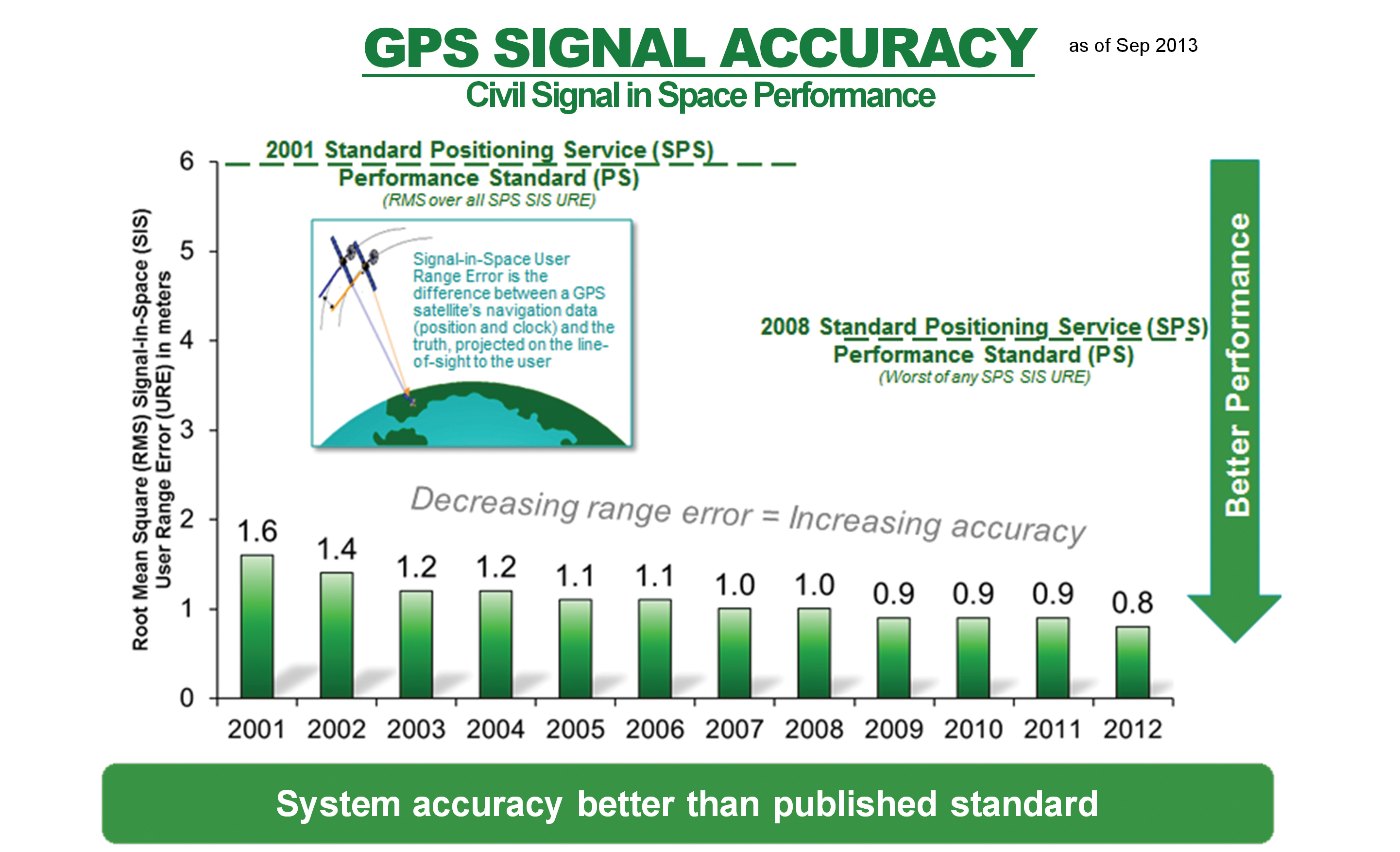
    Current System Performance

    Single-frequency horizontal, vertical, and three-dimensional positioning accuracy has been achieved at levels better than 10 meters, 10 meters, and 14 meters, respectively. Timing accuracy is better than 50 nanoseconds. Velocity accuracy is better than 0.2 meters per second. Carrier-phase differential accuracy is about 2–3 centimeters. During the past year, BDS has been continuously improved and enhanced, while its service performances in some regions dramatically surpassed the indicators given earlier.

    Application Promotion

    The application of BDS has played an important role in China, especially in advancing science and technology. Chinese scientists and engineers have intelligently and enthusiastically embraced China’s independent navigation satellite system and have made great progress in research and development of navigation satellite technologies, as well as new breakthroughs in the production of navigation chips, antennas, terminals, and integrated services.

    In 2012, the total output value of China’s satellite navigation and location-based service (LBS) industries reached 81 billion renminbi (RMB, equivalent to $13.2 billion), which amounts to 8 percent of the global sector. At the end of 2012, BDS civil user terminals totaled 230,000 units, and BDS-related industrial output value was close to 4 billion RMB ($652 million), which is about 5 percent of the national output.

    A series of policies aimed at strengthening the application of satellite navigation are under formulation in China, and the Mid- and Long-Term Development Plan for the National Satellite Navigation Industry has been issued. Satellite navigation has become one of the emerging industries with strategic importance. BDS is propelling China’s satellite navigation and LBS industries into a new era.

    Distribution of visible in-orbit BeiDou satellites.
    Distribution of visible in-orbit BeiDou satellites.

    International Cooperation

    China upholds and adheres to the concept of “BeiDou is of China, and also of the world,” advocating compatibility and interoperability among navigation satellite systems, and endeavoring to stimulate global widespread use of navigation satellite systems. To enable users to enjoy more reliable and ensured satellite navigation services, BDS has joined in international GNSS monitoring and assessment cooperation, making use of global monitoring stations, sharing international monitoring statistics, implementing joint assessment studies, and striving to offer trustworthy monitoring and assessment data and products to users.

    To achieve BDS’ envisioned coverage area more quickly, the BeiDou+ Application Demonstration and Experience Campaign (BADEC) has been initiated. “BeiDou’s tour to the Asian-Pacific region” and “BeiDou’s tour to the ASEAN” have been kicked off to accelerate application promotion of navigation satellite systems in many countries. To popularize satellite navigation technologies, particularly enhancing its recognition and application in developing countries, BDS has provided academic education, short-term training, and thematic lectures with support from International GNSS Exchange and Training Center.

    China also holds the annual China Satellite Navigation Conference, actively participates in international exchange activities on satellite navigation, and engages in academic exchanges, high-level forums, and popularization of knowledge.

    Future Outlook

    BDS is also committed to:

    • establishing navigation-satellite augmentation systems in the Asia-Pacific region and worldwide, developing better service performances, to provide decimeter-level accuracy in real time and centimeter-level accuracy after post-processing;
    • setting up satellite-navigation products-quality testing certification centers;
    • speeding up formulation of standards and intellectual property rights;
    •  joining international organizations such as the International Civil Aviation Organization (ICAO), International Maritime Organization (IMO), and Third-Generation mobile communication standard Partnership Project (3GPP);
    • strengthening compatibility and interoperability with the other navigation satellite systems;
    • promoting BDS/GNSS applications in transportation, energy, power, finance, telecommunication, disaster reduction and relief, and so on, to realize the BDS objective of serving the world and benefiting mankind.

    BDS will fully exploit the unique advantages of navigation, communication, and augmentation integration, enhance its short message service (SMS), and providing faster positioning and timing capabilities. BDS will also effectively integrate satellite- and ground-based augmentation systems, and insist on implementations of compatibility and interoperability among multi-GNSS, to enable its organic integration with mobile communication, LBS, and the Internet, and provide better quality, more reliable and efficient services to eco-social development, public security, and individual users.


    Chengqi Ran is the director general of the China Satellite Navigation Office and press spokesman of BeiDou Navigation Satellite System. He graduated from Tsinghua University with a Master’s degree in industrial engineering, and previously was director of the General Technology Department in the China Satellite Navigation Project Center.

  • Directions 2014: New Horizons of GLONASS

    Denis Lyskov
    Denis Lyskov

    By Denis Lyskov, Deputy Head of the Russian Space Agency, Roscosmos

    The fundamentals of Russian government policy in satellite navigation are defined in Presidential Decree #638 of May 17, 2007, and specify that:

    • GLONASS services are provided globally and free of any user fees;
    • GLONASS is used as a basis of the National Positioning, Navigation and Timing System.

    To efficiently implement the government policy in satellite navigation, in March 2012 the Government approved the dedicated Federal Program focused on GLONASS sustainment, development, and expansion of applications. This program covers activities aimed at:

    • improving the accuracy and integrity of navigation;
    • ensuring conditions for guaranteed positioning, navigation, and timing solutions in restricted visibility, interference, and jamming environments;
    • enhancing current application efficiency and broadening application domains.

    This year, the extensive efforts aimed at development of new generation GLONASS satellites, augmentations, and performance monitoring facilities were taken. The results obtained help to define the main directions of GLONASS development for the upcoming years.

    Space Segment

    The new navigation satellite will ensure navigation services for all categories of users using current frequency-division multiple access (FDMA) signals in L1 and L2 as well as new code-division multiple-access (CDMA) signals in L1, L2, and L3 bands. The full set of GLONASS signals will be transmitted using two separate phased antenna arrays — one for FDMA signals, and the other for CDMA signals. Introduction of new signals broadens the possibilities of improving the GLONASS orbital constellation configuration, structure and composition of navigation message data, as well as accuracy, reliability, and integrity of navigation solutions in various conditions. The constellation sustainment plan includes the launch of GLONASS-M-55 satellite in 2014. This satellite, similar to GLONASS-K-11 launched in February 2011, will carry an L3 navigation payload and transmit a CDMA signal in L3.

    The L3 CDMA signal will also be transmitted from seven more GLONASS-M satellites planned for launch in 2014–2015.

    The implementation of a GLONASS modernization program will produce a more than four-fold improvement of accuracy. This will be made by means of:

    • ground control segment upgrade;
    • introduction of a new on-board atomic frequency standard, based on different technologies;
    • introduction of advanced technologies of satellite control, based on intersatellite links in radio frequency and optical bands;
    • transition to PZ-90.11 Geodetic Reference System aligned to the International Terrestrial Reference Frame (ITRF) at the millimeter level;
    • synchronization of the GLONASS time scale with Coordinated Universal Time UTC (SU, for Soviet Union) at the level of less than 2 nanoseconds while keeping the UTC (SU) own long-term stability at 10-17.

    Augmentations

    Augmentations play an important role in improving GLONASS performance. With the launch of Luch-5V into an orbital position of 95° E in 2014, the first phase of the System of Differential Correction and Monitoring (SDCM) constellation deployment will be completed. SDCM will provide satellite-based augmentation services (SBAS) in L1 (1575.42 MHz). Simultaneously, the deployment in the Far East of the Russian Federation of uploading and monitoring facilities for Luch-5A positioned at 167° E will be completed. Special attention is being paid to ensuring compatibility of Luch-5B satellite (16° E) and Inmarsat-3F2 satellite (15.5° W) carrying a European Geostationary Navigation Overlay System (EGNOS) payload.

    The future transition to using heavier satellites carrying L1/L5 transponders will present an important stage of SDCM development. The first launch of such satellites is tentatively planned for 2018.

    With the purpose of improving the quality of SDCM services, the ground network consisting of several dozen sites will be deployed over the Russian territory, and more stations will be deployed along the Russian border to improve the accuracy of generating the vertical ionospheric delay map.

    Apart from SBAS technology development, a system for ensuring Precise Point Positioning (PPP)service is planned for development. PPP service will be provided using geostationary Earth-orbit (GEO) satellites transmitting in L1/L3 GLONASS bands. The L1/L3 transponders are planned to be installed on board future GEO satellites. Considering the common parameters (carrier frequency, pseudorandom noise pulse rate, data rate) of PPP and GLONASS’ own signals, the informative capacity of the former is an order of magnitude greater to ensure rapid broadcast of high-precision orbits and clocks.

    For PPP technology development, the global network of measuring facilities is of extreme importance. The global network ensures global monitoring of navigation signals and generation of initial data for high-precision determination and prediction of orbits and clocks.

    International Cooperation

    Cooperation with GNSS providers focuses on protecting the spectrum allocated to radionavigation satellite service, pursuing compatibility and interoperability of GLONASS and SDCM with other GNSSs and augmentations, creating an international GNSS monitoring system.

    One of the priority directions of international scientific cooperation is the cooperation with the International GNSS Service through the exchange of measurement information between its members. At the same time, GLONASS measuring and monitoring facilities will receive and monitor all open navigation signals of all GNSSs.

    A lot of attention is paid to enhancing GLONASS awareness. Since 2009, the International School on Satellite Navigation has been held annually in the Russian Federation. The Russian Federation has been preparing to host the United Nations Workshop on the Applications of Global Satellite Navigation Systems.


    Denis Lyskov is state-secretary, deputy head of the Federal Space Agency of Russia (Roscosmos). He started his carrier in the Russian space industry after graduation from the Moscow Aviation Institute in 1996. He has been working in Roscosmos for the last two years and supervising the GLONASS program since June 2013.

  • Directions 2014: Keeping Our Commitment to Civil Users

    Directions 2014: Keeping Our Commitment to Civil Users

    Colonel William T. “Bill” Cooley.
    Colonel William T. “Bill” Cooley.

    By Colonel William T. “Bill” Cooley, U.S. Air Force, Director, Global Positioning System

    The cliché “time flies when you’re having fun” accurately describes how quickly the past six months have passed for me. In a program as challenging, rewarding, and mission-critical as GPS, it is full-speed ahead all the time. As the GPS director, I am acutely aware of the importance of time — particularly high-accuracy time. Since declaring initial operational capability in December 1993, the extremely precise time service delivered by GPS has enabled numerous technological advances around the globe. While extremely proud of the accomplishments over the past 20 years, I look forward to the next 20 years, as GPS brings on new signals and continues to deliver on its promise of a worldwide free positioning, navigation, and timing (PNT) service. This article elaborates on the GPS Directorate commitment, along with the 2nd Space Operations Squadron (2 SOPS), to provide unparalleled space-based PNT accuracy, availability, and reliability to the civil community.

    The first commitment, arguably the most important for users everywhere, is the commitment to high accuracy for space-based PNT. After speaking at the ION GNSS+ conference and meeting many of you in Nashville this September, I realized that some users remain worried that selective availability (SA) — the intentional degradation of public GPS signals — could return and negatively impact GPS signal quality. SA was discontinued in May 2000 to provide an increased level of accuracy to all users around the globe. Since that time, the U.S. government has adopted a policy to no longer use SA and, furthermore, in 2007 removed that function from the upcoming GPS III satellites. The GPS Performance Standard for the Standard Positioning Service reflects our commitment to accuracy by ensuring the signal-in-space (SIS) user range error remains low: better than 4-meter accuracy. Figure 1 shows the record-setting SIS accuracy and how GPS meets and far exceeds this guarantee: consistently better than 1-meter accuracy! The 2 SOPS operators who command and control the GPS satellites do a masterful job ensuring global PNT accuracy is as good as it can be.

    Figure 1. Standard Positioning Service signal-in-space performance.
    Figure 1. Standard Positioning Service signal-in-space performance.

    The quality of these services, however, does not permit the GPS enterprise to rest in the comfort of past success. We are dedicated to updating and modernizing the program.

    The second commitment I’d like to highlight includes the GPS pledge for constellation sustainment and service availability. This is a guarantee to maintain a constellation of at least 24 satellites continuously broadcasting the GPS signals, providing a low dilution-of-precision value around the globe. Current efforts to meet this commitment range from replenishing unhealthy satellites to deploying improved, modernized satellites and corresponding ground support. For example, the GPS IIF satellites are rapidly becoming an integral part of the GPS constellation. With four IIFs on-orbit and a fifth soon to be launched, the constellation continues to exceed the 24-satellite requirement.

    The third commitment — to modernize the GPS constellation with new signals — is best illustrated by, but not limited to, the modernized GPS IIF and GPS III satellites that are beginning to populate the constellation. In addition to four GPS IIF satellites now on orbit, the remaining GPS IIFs are either ready for launch or in final testing.

    Down the road, GPS III satellites are completing development and progressing through early production. They will add the fourth civil signal, L1C, for civil users worldwide. Earlier this year, the GPS III program shipped the GPS non-flight satellite testbed (an engineering development unit) to Cape Canaveral; it successfully communicated with the next-generation operational control system (OCX), essentially as it would for launch and on-orbit check and control of functional GPS III satellites. The operational portion of the GPS ground segment, OCX Block 1 is on track to begin operations in 2016, modernizing the control segment by providing mission operation control of all legacy signals, as well as L2C and L5; later, OCX Block 2 will support L1C.

    GPS civil users will soon be able to take advantage of the L2C and L5 signals that broadcast the modernized civil navigation message (CNAV); this will effectively eliminate the need to access the L1 and L2 P(Y) signals through codeless or semi-codeless techniques. These codes permit civil users to access dual-frequency solutions for precision applications (using dual-frequency enables ionospheric corrections for highly accurate PNT solutions). Compared to the L1 C/A signal, L2C features faster signal acquisition, enhanced reliability, and greater operating range. L5 will provide for increased safety-of-life applications with broadcast power even greater than L1 C/A and L2C combined, increased bandwidth, and advanced signal design. Regardless of the early availability of L2C and L5, semi-codeless users will be able to access P(Y) code — unhindered and unaffected by fully tested and vetted flex-power operations — until the end of 2020. Overall, these modernization efforts emphasize a commitment that availability surpasses simply putting satellites on orbit.

    Finally, the GPS Directorate is committed to providing a high-quality service that is highly reliable. We achieve this by fielding first-rate satellites, conducting extensive test campaigns before deploying new capabilities or launching new satellites, and working closely with the operators at 2 SOPS, ensuring our constellation delivers top-quality PNT signals. An example of diligent testing is the recent live-sky test of the CNAV message on all GPS IIR-M and IIF satellites this past June. An example of a modernization feature that will enhance reliability is the capability of GPS III satellites to autonomously monitor the atomic clocks that drive the signal, thereby protecting users from clock instability and resulting signal errors.

    Our demonstrated commitment to deliver accurate, available, and reliable space-based PNT allows innovators around the world to invest confidently in the creation of a multitude of GPS and GPS-enabled technologies that shape the way we live. GPS and its related technologies go far beyond letting you find the deli down the street and “checking in” to let your friends know what you’re up to on Facebook; it tracks financial transactions, enables precision farming, and allows accurate real-time updates on natural disasters such as earthquakes and tsunamis with capabilities that organizations like the NASA Jet Propulsion Laboratory and the International GNSS Service provide using GPS. The GPS Directorate is keenly aware that innovators invest their time and talent because they know they can depend on GPS availability. Our commitments are not just “feel-good” words; they are our mission and promise to the world.

    I am very proud of the men and women in the GPS Directorate and thrilled to be part of this great team as the new GPS program director. The commitments listed here provide a glimpse into the services provided by the GPS enterprise. I am excited about bringing modernized signals to the world, but more excited to learn how the PNT community will use these signals to develop new innovative and useful applications. The world is easier to navigate because of GPS and GPS-enabled technologies, all of which rely on services the GPS enterprise provides: accuracy, availability, and reliability. We are committed to delivering these services as we modernize and improve the enterprise to continue GPS as the gold standard of space-based PNT.


    Colonel William L. cooley is Director, Global Positioning Systems (GPS) Directorate, Space and Missile Systems Center, Air Force Space Command, Los Angeles Air Force Base, California.

  • Directions 2014: On the Path to Early Services

    Directions 2014: On the Path to Early Services

    Headshots: Eric Chatre, Horst Faas, and Marco Lisi By Eric Chatre, Horst Faas, and Marco Lisi

    With four satellites in space, launched by pairs in October 2011 and October 2012 from French Guiana, the Galileo project is now successfully completing the In-Orbit Validation (IOV) phase. The Galileo space, ground, and user segments have been qualified through extensive on-ground and in-orbit tests, and operations, of a core satellite constellation and the associated ground segment.

    The IOV architecture is being implemented as an integral part of the Full Operational Capability (FOC) — that is, the complete system, consisting of 30 satellites and a set of remote stations distributed worldwide to command and monitor the constellation and deliver the navigation and timing services to the users. Now that the overall design has been validated, the system will be progressively completed, in a staggered approach, to reach the FOC.

    Figure 1. Galileo System Architecture.
    Figure 1. Galileo System Architecture.

    Galileo System Overview

    A joint initiative by the European Union and the European Space Agency, Galileo is one of the most ambitious and technologically advanced service-oriented systems being developed in Europe. A navigation satellite programme under civilian control, it is meant to provide positioning, navigation and timing signals on a global scale.

    Galileo is based on a constellation of 30 satellites organized in a 24-satellite nominal constellation plus six active spares, a worldwide network of ground stations, and a number of Control Centres established in Europe to control the constellation, perform the navigation mission management, and monitor system performances

    The Galileo programme is following an incremental path towards the deployment of the complete system and the exploitation of services.

    Figure 2. Galileo Incremental Implementation Plan.
    Figure 2. Galileo Incremental Implementation Plan.

    The programme has been structured according to the main following phases:

    • IOV phase, to develop and validate in-orbit performance;
    • Initial Operational Capability (IOC) phase, including Early Services, to start delivering limited but guaranteed services, promoting chipset and receiver developments, downstream applications, and pilot projects by EU Member States;
    • FOC phase, to deploy in full the ground and space infrastructure as required for full operational capability;
    • Operations and service provision phase to operate the FOC infrastructure and provide navigation services over the system lifetime.

    The definition, development, and IOV phases of Galileo were carried out by the European Space Agency (ESA) and co-funded by ESA and the European Union. The FOC phase is managed and fully funded by the European Union and supervised by the European Commission (EC). The EC and ESA have signed a delegation agreement under which ESA acts as design and procurement agent on behalf of the EC.

    Galileo Early Services

    ESA began navigation systems research and development in cooperation with the EC and the civil aviation community. The development strategy was conceived with two major pillars: the European Geostationary Navigation Overlay Service (EGNOS), a pan-European augmentation system, complementing GPS to deliver reliability information to users, and Galileo. Today, EGNOS is operational and certified, forming the basis of a wide range of general and safety-critical applications across the European continent.

    Once Galileo becomes operational, a portfolio of navigation services will be offered by Galileo and EGNOS, based on varying user needs.

    Galileo’s full operations and services will commence when all the satellites have been deployed, with the complete constellation of operational satellites and spares, supported by an extensive network of ground stations and local and regional service centres in their final configuration.

    However, after a political decision by EC Vice-President Antonio Tajani, Galileo will start officially delivering Early Services as from the end of 2014.

    Based on the space and ground configuration available in 2014, the following early services are targeted:

    • Open Service: delivery of stable E1, E5a, and E5b signals in space from a number of satellites in orbit, allowing users to perform ranging, E1 and E5a being interoperable with GPS;
    • Public Regulated Service: delivery of stable, secure E1 and E6 signals in space allowing pilot projects with EU Member States, to demonstrate PRS management capabilities;
    • Search and Rescue: guaranteed SAR forward link, which allows the detection and localization of COSPAS-SARSAT distress beacons;
    • Commercial Services: initial demonstration of precise positioning and authentication services with potential service providers.

    The Early Services phase is being prepared in close coordination by engineers from the EC, the European GNSS Agency (GSA), and ESA. The activities include the definition and procurement of infrastructural assets other than the Galileo core system, namely the GNSS Service Centre, which is the interface with user communities, and the Galileo Reference Centre to monitor service performance. Organizational and operational pillars of the Early Services provision are also defined with the public and industrial organizations involved and their governance and with all processes required for the delivery of services with all their dynamics. A service definition document defining expected service behavior and non-functional properties will be made available to all users through the GNSS Service Centre website.

    Figure 3. Galileo Early Services Organisation.
    Figure 3. Galileo Early Services Organisation.

    Service performance will be monitored by the Galileo Reference Centre over time by means of key performance indicators (KPIs), with target values and target ranges to be achieved over a certain time period. As far as processes are concerned, performance (quality, reliability, throughput), productivity (efficiency, effectiveness) and safeguards (security, safety) will be monitored over time.

    Prior to official declaration of the Early Services, KPIs and technical performance will be monitored during a Service Validation Phase, aiming at a confirmation of the readiness of the overall service organization.

    Figure 4. Service Validation Activities.
    Figure 4. Service Validation Activities.

    As part of the service validation, receiver and chipset manufacturers will be offered the possibility to test the performance of Galileo. The objective is to verify the market readiness and optimize Galileo use in a multi-constellation environment. A call for interest went out in July 2013, and leading mass-market chipset and professional receiver manufacturers have expressed interest in participating in the test campaign.

    The tests have been adapted to the nature of the applications and markets targeted by each manufacturer. A first set of tests is planned at ESA, focusing on mass markets. These tests will evaluate assisted GNSS performance in difficult environments such as urban canyons. They will also address the need for a seamless switch from outdoor to indoor.

    Another set of tests is planned at the European Union Joint Research Centre (JRC). They will respond to the needs of high-precision users, testing, for example, dual frequencies. Each test will be performed for different combinations of available GNSS to evaluate and demonstrate the added value of Galileo. The testing will start at the beginning of 2014 with laboratory tests based on simulated data and will continue during 2014 using real Galileo data.

    Conclusion

    Galileo will be an autonomous, global, European-controlled GNSS providing several guaranteed services to users equipped with Galileo-compatible receivers. From a value-chain viewpoint, Galileo is a system providing services meant to support or make feasible other service systems. Together with the introduction of state-of-the-art technology and of very complex system architecture, the delivery of sophisticated services is established on well-defined governance, operational, and regulatory bases.

    After the successful completion of the IOV phase, Early Services will mark a new, substantial milestone towards the system’s full operational maturity and the exploitation of its capabilities and services.


    Eric Chatre is the Head of Sector on Services and Exploitation for the EU Satellite Navigation Programmes in the European Commission, EC. Horst Faas is GNSS exploitation programme manager at the European GNSS Agency (GSA). Marco Lisi is GNSS services engineering manager at the European Space Agency.