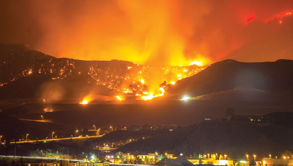
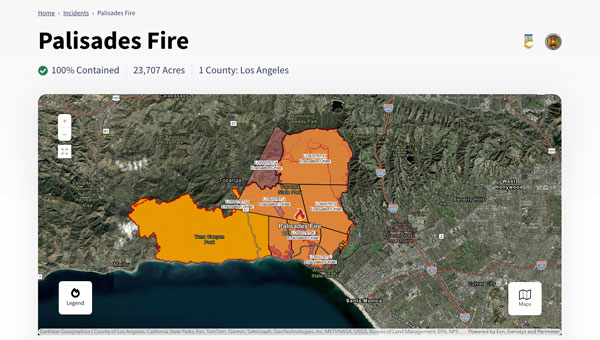
The Palisades and Eaton fires devastated parts of Los Angeles in January 2025 and are largely contained as of Jan. 20. Fueled by extreme Santa Ana winds and dry conditions, these fires have left a mark on the region’s landscape and community.
The Palisades Fire, which originated in the Pacific Palisades on Jan. 7, ultimately burned 23,448 acres, resulted in 12 confirmed fatalities and destroyed or damaged more than 6,800 structures, according to the California Department of Forestry and Fire Protection, known as CAL FIRE. The fire’s rapid expansion was particularly alarming, growing from a small brush fire to a massive conflagration within an hour.
Simultaneously, the Eaton Fire, which began near Altadena and Pasadena, consumed 14,117 acres. This fire proved even more deadly, with 17 confirmed fatalities and significant damage to more than 10,000 structures, according to CAL FIRE. Both the Palisades and Eaton fires have now been classified among the most destructive wildfires in California’s history.
During times of emergency, geographic information systems (GIS) specialists come together to create real-time mapping tools to provide critical support to first responders and keep communities well-informed. These tools have become indispensable in modern disaster management, particularly in wildfire response.
Interactive 3D Maps
Firefighters and other specialists from federal, state, and local agencies work together to fight wildfires. GIS specialists develop interactive 3D maps to display fire perimeters, evacuation zones and other critical data. The geospatial data serves as the foundation for effective communication and decision-making, allowing firefighters and incident management teams to access information in near real-time to make informed decisions.
Fire GIS specialists Peter Rowland, Brett Adler and Dawn Hutchinson shared insights into their teams’ strategies for wildfire management. They emphasize the crucial role of geospatial tools in disaster response by delivering actionable intelligence. GPS World interviewed them during the California wildfires. Rowland and Adler were based at the Palisades fire, while Hutchinson, who is a member of a California Interagency Incident Management Team (CIIMT), was located near the Eaton fire.
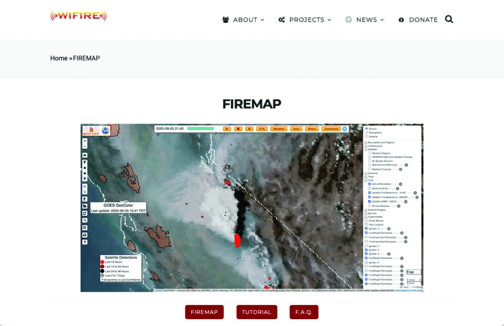
Interagency GIS teams use the Fire Integrated Real-Time Intelligence System (FIRIS) to watch for fire starts and then receive alerts from dispatch centers and satellite imagery. After locating the point of ignition, they create fire behavior models using a program called WIFIRE from UC San Diego. This tool allows them to predict the fire’s probable trajectory and size.
Photo: CAL FIRE
The team will alert the state if the data shows the fire is likely to spread. Hutchinson explains that, within minutes of the start of the Eaton fire, her team produced a fire behavior model that illustrated where the fire was most likely to go and how big it would likely get within the next three hours.
Photo: CAL FIRE
The frequency of IR flights depends on the fire’s size and intensity. Occurring anywhere from once to three times daily, including nighttime, these flights comprehensively map the landscape based on the fire’s specific traits. The decision on how often to fly the planes and collect the IR data depends on the fire’s behavior and potential threat level.
Field observers are also deployed daily to collect data down to the debris. They walk the fire’s edge and move along specific paths created for wildfire management and containment. Once a fire is contained, GIS specialists try to verify ground truth for the perimeter of the entire fire.
GIS specialists constantly update fire perimeters as they get data from the field and the planes. Once a fire is contained, they create final maps to hand over to the local agencies or the Forest Service.
Photo: CAL FIRE
Most of the data that GIS specialists use to map fires comes from field observers and infrared (IR) thermal imagery. The data is collected by third-party contractors, by CAL FIRE’s Intel shift team, or by the FIRIS program by flying manned aircraft.
IR data and information collected by field observers are then uploaded into the National Incident Feature Service (NIFS) for GIS specialists to use to map fires.
Field observers download the maps onto their devices, go out into the field, and ground truth — physically walking the perimeter of the fire and using GPS on their devices to map the fire boundaries accurately.
Photo: CAL FIRE
Paper maps are good to have “just to get everybody on the same page without having to worry about battery life or the glare while you’re working out in the field,” said Rowland.
Along with online maps, the Interagency GIS teams print PDF maps for fire personnel in the field. The field observers use Esri ArcGIS Field Maps to record their tracks. They pair their mobile devices with Avenza or other geolocating applications.
Using ArcGIS Pro, GIS specialists create online maps and dashboards, which are then distributed in print and/or digitally to the agencies that need them, such as sheriff and police departments and departments of public works. The Interagency GIS teams create different map products for different end users. For example, it works with law enforcement to create evacuation maps and zones. Local public information officers also can distribute these maps or post them on their websites.
Photo: CAL FIRE
Crews also have online access to the maps through wildfire FTP (ftp.wildfire.gov). Crews load data and maps there that contain public information. Many agencies plug into the National Interagency Fire Center (NIFC), where the CAL FIRE team edits and analyzes mobile data.
Hurricane Ida assessment imagery and data are now available. Ida was a Category 4 Atlantic hurricane from Aug. 26 to Sep. 4. (Screenshot: NOAA)
Applanix, a Trimble Company, and the National Oceanic and Atmospheric Administration (NOAA) have collaborated to provide critical information to first responders in the wake of Hurricanes Henri and Ida.
Applanix’s high-accuracy direct georeferencing (DG) technology enabled NOAA to quickly collect aerial mapping imagery to
provide valuable disaster remediation information to first responders
demonstrate the value of mapping technology in preparing for and responding to emergency situations such as hurricanes, tornadoes and other disasters.
Within hours of Hurricanes Henri and Ida making landfall, NOAA’s National Geodetic Survey collected post-storm imagery using the latest generation Digital Sensor System (DSS). The sixth-generation DSS, designed and manufactured for Applanix by Lead’Air, is the most powerful to date, thanks to several new features introduced within the solution:
simultaneous full color and near-infrared image capture using high-performance Phase One iXM 100 MP NIR and 150 MP RGB cameras
option to fly the cameras in wide coverage oblique or traditional overhead (straight line down) mode for mapping with uninterrupted measurement
embedded Trimble AP60 GNSS + inertial OEM DG solution for mapping without the need for ground control or aerial triangulation
Applanix POSPac post-processing software featuring the Trimble post-processed CenterPoint RTX correction service (PP-RTX) for centimeter-level mapping without GNSS reference stations
in-air development of raw imagery to JPEG-ready files for creating map products immediately upon landing
Lead’Air’s X-Track flight management, which enables the system to be flown outside of planned flight lines to follow roads, rivers and coastlines.
Applanix’s DG technology suite provides direct GNSS inertial georeferencing, meaning that all pixels in the aerial images taken by NOAA are mapped at their exact location on the ground.
“We have worked with Applanix for nearly 20 years,” said Michael L. Aslaksen Jr., chief of the remote-sensing division, NOAA’s National Geodetic Survey. “The level of sophistication they bring to aerial imagery and mapping keeps our team at the forefront of the industry. Their customer support team is always open to new ideas, new innovations and doing whatever it takes to get the job done.”
First responders have access to this imagery and mapping within 24 hours via the cloud (as does anyone at storms.ngs.noaa.gov) and can map detailed response plans based on highly accurate data highlighting where the greatest need lies.
Access to this turnkey emergency response imagery is available to any federal agency, municipality, insurance company or other entity that depends on highly accurate information to plan for and recover from disasters.
Dewberry, a privately held professional services firm, has been selected as a consultant to Civis Analytics to perform comprehensive data analytics, including flood hazard and property loss modeling and damage estimation, to support the city of Houston’s post-Hurricane Harvey recovery efforts.
Hurricane Harvey flooding in Houston. (Photo: FEMA)
The granular, structure-level understanding of this catastrophic flooding event will be critically important to the city’s efforts to catalog impacts and direct resources to the rebuilding and recovery efforts, Dewberry said.
The resulting data will be made accessible to authenticated city staff and non-profit organizations through the new Houston Estimation and Analysis of Loss (HEAL) platform. A cloud-based system that will be used in disaster mitigation planning, HEAL will aggregate data, analytics, tools and visualizations in a web-based environment available to city, state and federal officials and other stakeholders.
Hurricane Harvey flooding in Houston. (Photo: FEMA)
The data development effort featured a hindcast model of the historic Hurricane Harvey storm event, which dropped 51 inches of rainfall within the city of Houston and surrounding areas over five days in August.
The HEAL platform will provide the city with a comprehensive data collection and analytical architecture with the ability to calculate and report unmet needs at various levels, such as structure, parcel and census block.
The analytics will include extensive modeling to estimate flood depth and extent and the structural and contents losses created by it. Model validation will use a wide set of data from debris removal pickup locations, and community field data collection, to federal assistance information, as well as non-traditional sources such as social media videos.
Hurricane Harvey flooding in Houston. (Photo: FEMA)
For this complex project, Dewberry’s innovative approach has involved strong applications of science and engineering including meteorological data processing, 2D flood risk modeling, and damage assessment to replicate post-Harvey conditions in Houston.
GPS World held a webinar on new unmanned aircraft initiatives on May 21 led by a panel of experts. On hand were Don Mark of the law firm Fafinski, Mark and Johnson; James Spicer and Adrien Perkins, both students in aeronautics and astronautics at Stanford University; and Peter Cosyn site manager and director of research and development at Gatewing, a Trimble company. I also participated.
Alan Cameron, editor-in-chief and publisher of GPS World, hosted the event and introduced the participants. Around 300 people signed up to listen to the webinar and ask questions.
Don Mark provided a legal overview of the FAA’s regulations for UAS, FAA and U.S. Senate initiatives, James Spicer and Adrien Perkins reviewed the Jäger UAV jammer detection project, and Peter Cosyn provided an overview of the Gatewing/Trimble UX5 UAS solution. I provided insight into recent UAS industry.
Finally, the panel discussed a few of several written questions submitted by the webinar attendees. We promised to publish both these questions and our attempt at providing answers. Please bear in mind that this is new area of technology, applications and regulations governing operations — so we welcome clarifications and inputs as we may miss the mark occasionally!
Q&A for GPS World Webinar:
“New Frontiers in Unmanned Flight: Hey You, UAV!”
Is the FAA going to keep requiring a pilot’s license to operate a UAV?
The draft sUAS rulemaking proposed by the FAA does not require a pilot’s license. Instead, there’s a requirement to pass an aeronautical knowledge test, obtain an FAA UAS operator certificate and to pass an FAA knowledge test every 24 months. However, the Section 333 exemptions granted by FAA so far have all required that the operator have a private pilot’s license.
What are the effects (operational, legal) of GNSS receiver failures in UAV missions and what are some technical measures to avoid them?
Most UAS used within a critical or commercial operation not only carry GNSS, but also have some form of navigation back-up system — MEMS inertial being the most common — so navigation is still possible, albeit for a short time with any degree of accuracy. And in the event of a communications link failure, the norm is to have the UAV follow a pre-programmed “return-to-base” route, so the vehicle returns safely to a known location.
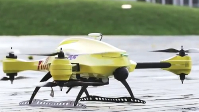
What is the development of UAVs in the healthcare industry?
There are a number of ongoing and proposed applications of drones that are health related. A prototype system in Delft, Netherlands, carries a defibrillator to be used to revive heart-attack victims. The concept is that a network of geographically distributed drones would be called from a cellphone, and the closest UAV would be dispatched and would be able to arrive much quicker than a conventional ambulance.
This drone is part of a prototype healthcare delivery system in Delft, designed to carry a defibrillator to heart attack victims and caregivers.
Other healthcare applications could include the rapid delivery of vaccines, medications and supplies delivered right to the source of an outbreak. This could more rapidly reduce the incidence of life-threatening communicable diseases. Communication equipment, mobile technology and portable shelters could be delivered in a rapid fashion to areas where critical infrastructure damage would prevent ground or typical air transport. Drones have also been used extensively in disaster relief efforts.
Also, in July, unmanned aerial vehicles will deliver medical supplies to a free health clinic in Wise, Virginia. The most urgent prescriptions will be provided by pharmacies located out of town. To get the medicine to the community as soon as possible, the pharmacies will deliver them to their local airport, where they will be collected by NASA’s fixed-winged aircraft and be flown to Lonesome Pine Airport. When the prescriptions arrive there, they will be loaded onto Flirtey drones and delivered to the Wise County Fairground. Flirtey drones are expected to deliver around 24 packages of prescription medication.
Please describe LiDAR systems available for UAVs.
There are many lightweight LIDAR systems on the market for UAV applications — some even come integrated within their own operational drone system. Coupling drone-mounted LiDAR systems with vision cameras, advanced computer processing and GPS, it has now become possible to create a remotely piloted flying LiDAR scanner.
Routescene’s LiDAR pod attached to the belly of a UAV.
Update us on legal matters within the European Union?
The EU has been very active in preparing for the commercial use of UAS, so drone use in the EU appears to be significantly higher than in North America because of the proactive effort of regulators to introduce drones into regular commercial applications. This Forbes article summarizes the approach being taken and the progress towards introducing regulations within the EU by the end of 2015.
You speak of “UAV navigation in environments where traditional GPS receivers may fail.” Are you considering indoors navigation or “just” urban environment?
It’s true that drones are being operated indoors — for instance, within restaurants. In these environments, all the typical indoor navigation techniques will be viable — RF/magnetic fingerprinting, Bluetooth beacons, Wi-Fi source databases, cellphone signals including small cells, and even optical sensors, all often combined with indoor maps.
Urban environments with a restricted view of the sky also continue to challenge GNSS only navigation, which has led to extensive use of integrated inertial/GNSS navigation sensors.
Modularity of UAVs? Different sensors for different types of applications using the same UAV?
A number of professional drone manufacturers offer UAS that could carry different payloads. However, most manufacturers seem to focus on particular applications (flying camera, LIDAR and/or video survey) and don’t carry an extensive range of optional third-party payload equipment.
What regulations are there for self-made UAS?
It’s hard to imagine that the regulations would be different for a commercially manufactured drone or a home-built UAS. Only time will tell as regulations are developed that include this category of UAS.
What background and abilities should a team possess if it wants to develop a UAV?
An engineering team that takes on developing a UAV needs to be aware of the basics of flight, navigation and control/communications — these are the principle elements of UAV operations.
Do you exploit software-defined radio techniques?
Software-defined radios may find their way into UAVs whenever weight/volume are an issue, but they potentially require higher computing capability, and maybe somewhat higher power to run co-processors. Weight and power consumption are at a premium on small UAVs, so any initiative that saves in these areas will no doubt be welcomed.
What are the emerging application areas for UAVs?
It would seem that the application areas for UAVs are virtually unlimited. High interest areas include agriculture, pipelines, buildings and transmission line inspection, aerial survey, filmmaking and newsgathering, wildlife and environmental monitoring, fishing and military reconnaissance/weapons delivery. But there are many, many applications, some of which might not fit into this summary of applications.
When will the UAV market move beyond focusing on the drone itself and get to the important topic of what sensor technology and back-office systems provide the best value to the user? The UAV is a commodity.
Good comment — the utility of the UAV comes from the payload it carries and the analysis of the data it collects and how it can be operated.
I’m curious if the UAV mission will be used in conjunction with autonomous agricultural tractors and construction machinery. I’m assuming an off-site tractor operator would benefit from the aerial data for their scope of work.
Absolutely — another possible UAV application.
Do you know when high-altitude long-endurance solar-powered UAVs will start being used?
The key application being pursued by Google using high-altitude, long-endurance, solar-powered drones is to provide Internet coverage in areas that currently have no ground infrastructure. A number of countries around the world would benefit from connection to the Internet using this approach. Unfortunately, the prototype aircraft built by Titan Aerospace recently crashed. But Google has vowed to continue with its efforts. Another development, called Project Loon, involves the use of high-altitude balloons and is already well underway.
I am currently enrolled in the UAV Pilots Certificate Training Program offered through the Unmanned Vehicle University. Is this certificate, which costs $3500, going to actually benefit me in my future commercial operations? Does the FAA recognize it as anything valid? So unless the certificate provides me some practical advantage, I’m not sure if it was legitimate or a scam. Any thoughts on this or experience with this “University”?
A recent Senate bill seeks to establish the six FAA test centers as the authorities for training UAS pilots. However, it would appear that currently no universal training course has yet been developed or approved for UAS pilot training — so it may be premature at this stage to engage with third parties for training until guidelines are published by the FAA.
What is the positional uncertainty associated with the locational measure of GPS systems on these UAVs? What will it be in five years?
Depending on the application, accuracies between 1 meter and a few centimeters are being achieved. For higher accuracy requirements such as precision surveying, post-processing of data collected during a survey can provide accuracies within a few millimeters.
In five years’ time there will be more satellites in more constellations, and it’s possible that accuracies could improve further. However, the most benefit will come from having more reliable signals, more often, thereby reducing re-test and operational costs.
What industry do you see being the fastest adopter of UAV technology in the USA?
The U.S. military is already leading in the number of applications, number of operational UAS and number of different types of vehicles. Commercial applications have increased substantially now that the FAA has authorized a large number of civilian operations in the last year or so. There are a number of film and TV applications for movie-making and newsgathering, and this appears to be a growing area for commercial UAS. Aerial survey is also growing in popularity, and there is a huge range of monitoring applications for building inspection, pipeline and transmission line inspection, and also for crop growth monitoring — which may turn out eventually to have the highest number of applications in the U.S.
How do you think the industry should protect UAVs from GPS spoofing and other forms of remote or internal component (example ICS or SCADA) attacks?
Solutions to mitigate GNSS spoofing and signal jamming are currently high on the list of most receiver manufacturers’ development agendas, with several options already having reached the market. Anti-jam antennas, improved signal rejection in RF front ends, and algorithms that claim to be able to deduce and overcome spoofing attacks — these are the leading solutions that have been fielded. But we have only just scraped the surface of deceptive techniques being used and the frequency with which they are being encountered, so we should continue to see the solutions evolving to counteract more sophisticated interference and spoofing capabilities over time.
Will the upcoming regulations only impact commercial users, or will they also directly affect non-commercial and/or recreational operators?
In the U.S., regulations governing the operation of recreational or hobby aircraft appear to be less stringent than, say, a drone operating commercially. As long as common sense rules are observed, hobby aircraft operators have been able to operate without the FAA looking over their shoulders — provided they stay below 400 feet in an open space away from sensitive areas such as schools or hospitals and don’t make an inordinate amount of noise, no one has yet proposed more restrictions for hobbyist model aircraft operators. The focus for the FAA is currently on bringing drones safely into the national airspace system for commercial operations, so regulations so far have been mostly formulated to enable this to happen.
Proposed legislation in the USA refers to one pilot per vehicle; no mention is made of swarming or control of multiple vehicles per pilot. Is it worth developing apps that use swarms of UAVs at the moment?
Certainly, it’s been difficult for the FAA to introduce regulations for UAS that are acceptable for most anticipated commercial operators, while still respecting and protecting current manned aircraft operations. So far, we’ve had case-by-case approval for specific operations, while regulations for small UAS (sUAS) have only just been circulated for comments — and a huge number of comments have been received. So regulations for “regular-sized” and operated drones and for larger vehicles have not yet seen the light of day. So, the more complex applications involving the operation of a swarm of UAS may not yet have been even considered by the FAA. It has taken years to get this far, and we still don’t have any published regulations for any class of UAS in commercial applications, so it’s doubtful that there is any work underway on regulations for swarming drones. So develop apps if you wish, but don’t expect much regulatory support for some time yet.
What assurance do we have that a UAV operator won’t deliver a weapon instead of an Amazon purchase?
The exemptions that have been published allow certain well-defined, specific commercial operations of UAS. The unmanned vehicle has to be registered to an individual and get a unique tail number. The operators have to be identified and must regularly demonstrate proficiency and adequate knowledge to become a recognized operator. So authorities get to inspect the UAV, know the owner and know the operator, and even get to review and approve the location of each UAS operation — not that that would prevent someone subsequently modifying the vehicle to carry ordinance, or knowingly attacking a target. It would, however, be pretty easy to track down the offender, but that doesn’t really prevent “weaponization” or delivery. But we are only at the small-vehicle-level currently, so its doubtful if major damage would be possible with small weapons, but an individual attack might still be lethal. Careful screening of individuals seems to be the route the regulators have taken to minimize this risk. This is still a difficult issue that is going to take some policing and close control.
Instead of an actual pilot’s license required for legal flight of a UAV, do you think an all-encompassing UAV pilot’s license will be required? I ask because I am a trained Trimble UX5 pilot, but I do not have my pilot’s license. I also build UAVs, and I am curious how I would get a UAV pilot’s license for a UAV I built? Unless they had an all-encompassing training course for pilot/flight safety.
The FAA proposed rulemaking for sUAS operations did not require operators to have a pilot’s license. Instead, UAS operators are required to undertake a specific recurrent training course for UAS operators, administered by FAA qualified trainers. Regulations relating to “home-built” UAS have yet to emerge, and may be some time away from publication.
It is said that mainland China has over 70% of the world UAV market? How did we fall so far behind?
Lack of regulations in the U.S. may have held back U.S. industry — see related comments by Amazon in testimony to the U.S. Congress.
But also the absence of restrictions in other countries may have helped overseas manufacturers get established and to gain initial market share. While the majority of done R&D was initially within the U.S., it’s clear that DJI and its Phantom line of drones have become very popular, very quickly. Strangely enough, the largest concentration of buyers and operators currently appears to be in the U.S.
Insurance against UAVs crashing and causing damage to humans: what progress has been made in this area?
Several insurance companies are now writing risk-coverage policies for UAS, including Global Aerospace, USAIG, Allianz and AIG.
We are operating a GNSS reference network in Greece, SmartNet-Greece (Leica Geosystems). Is there a tested NTRIP system on UAVs, to be connected and monitored to Ntrip caster? How could this augment real-time GNSS accuracy of UAVs?
Seems like you are trying to get RTCM corrections from a ground network to a flying UAV – correct? So do we need an Internet connection to get your ground network RTCM corrections onto the UAV? I’m not an expert on available mobile Internet hook-ups, but most smartphones have one, so it can’t be that hard to add this onto a UAV. Alternatively, wouldn’t it be easier to have the GNSS receiver on the UAV listen to a PPP broadcast from one of the several services providing these corrections? We could get down as far as 10 cm accuracy with one of these commercially available correction services.
Talk about the possibilities of precise positioning in UAVs, instead of mapping.
Precise real-time positioning on a UAV is a question of which GNSS receiver is onboard and which PPP or local RTK network transmissions are available in the area of UAV operations. Positioning accuracy is possible of a few centimeters down to a few millimeters post-processed.
Realistically, how close are we to being able to fly UAVs for commercial applications such as topographic surveys and earthworks applications such as mining sites?
As we heard during the webcast, obtaining an FAA section 333 exemption is quite possible for these applications, and some have already been granted. The FAA has been streamlining the process recently to reduce the time it takes to obtain these authorizations.
What is a practical ceiling for UAV flight?
The FAA has limited UAS operations to below 400 feet in the Section 333 exemptions that have been granted, while 500 feet is used as the maximum ceiling in the proposed draft sUAS regulations.
What is status of technology for “see and avoid” requirements for UAVs?
NASA, the Federal Aviation Administration (FAA), General Atomics Aeronautical Systems (GA-ASI) and Honeywell International Inc. have successfully demonstrated a UAS proof-of-concept sense-and-avoid (SAA) system. GA-ASI worked with NASA’s Armstrong Flight Research Center to integrate the new system aboard NASA’s Ikhana research aircraft, a civilian version of the company’s Predator B. The flight-test campaign in November and December 2014 evaluated the SAA system in a wide variety of collision-avoidance and self-separation encounters between two remotely piloted aircraft and various manned aircraft and included a sensor-fusion algorithm being developed by Honeywell.
NASA’s Ikhana Predator B drone.
An RTCA subcommittee is also working in parallel to develop the requirements for an SAA system, and these flight-test evaluations will contribute to those technical standards.
Other companies that are also thought to be active in SAA development include Rockwell/Collins, Sierra Nevada and Insitu/ Queensland University of Technology Australia.
So, a large number of questions on a pretty wide range of subjects — hopefully some of the answers we’ve provided will be of assistance — but please provide us with your comments if you have information to share.
Disclaimer: The statements, questions, views and opinions presented in this article are those of the author and webcast audience, and may not necessarily reflect the opinions of GPS World magazine, its owners or staff. Readers are also warned that the answers are provided on a best-effort basis and could be less than 100% correct.
The increased use of Geographic Information Systems (GIS) in disaster management has resulted in the growth of the GIS market in China, which is expected to post a CAGR of 11.75 percent from 2014-2019, according to research from TechNavio.
The report “GIS Market in China 2015-2019” focuses on the increased use of GIS technology across various systems such as forest fire management, flood management and climate change, which has made GIS technology an effective tool for disaster management in China.
“Governments and natural resource sectors are heavily dependent on GIS for disaster management. The technology provides detailed information on an area’s geography, and any changes or deviations in the typical information can lead to an inspection by experts,” said Faisal Ghaus, vice president of TechNavio.
The report emphasizes increased investments in GIS software. The market is witnessing the presence of several large international GIS solution providers that are making huge investments, leading to high economic growth in China. “The increased adoption of GIS solutions across different sectors has motivated large international vendors to make investments in providing GIS solutions in China,” Ghaus said.
The report covers:
Market segmentation, size and forecast through 2019
Market growth drivers: Increased use of GIS for disaster management
Market challenges: Availability of open-source GIS software
Market trends: Increased investments in GIS software
Key vendors:
Autonavi Holdings Ltd.
HERE
Hexagon AB
NavInfo Co. Ltd.
Other vendors:
Autodesk
Beijing Supermap
Bentley System
China Information Technology
Other GIS market research reports available include:
An exercise in planning for months proves timely in light of Hurricane Sandy
By Art Kalinski
I was going to write about the increasing presence of social media at GEOINT 2012, but I’ll cover that next month since Hurricane Sandy made an exercise I attended last week more significant in its timeliness.
The Disaster Response Integrative Logistics Exercise was a joint effort of the Institute for Defense & Business and Lockheed Martin. Heading up the effort was retired U.S. Ambassador David Litt of the IDB and Corey Cook of Lockheed Martin. The almost week-long event was held at the Lockheed Martin Lighthouse located in Suffolk, Virginia, near Norfolk. The 65,000-square-foot high-technology facility is designed for experimentation and prototyping using analysis, modeling and simulation. It’s a reconfigurable command and control operations laboratory that permits participants to test and analyze concepts in a gaming environment.
The stated purpose of the disaster response exercise was: “Given the nature, frequency, location and severity of disasters, inter-organizational collaboration – to include the private sector – is becoming increasingly critical to the efficiency and effectiveness of logistics in disaster responses.” The exercise involved more than a 100 participants from the private sector, government agencies, non-profit organizations, and military services. Lou Kratz, Vice president and managing director, Logistics and Sustainment, Corporate Engineering & Technology for Lockheed Martin, stated that “Today’s crisis response efforts generally struggle with effective logistics collaboration among the multiple public and private stakeholders engaged. With our 21st-century logistics capabilities and global resources available from the public sector and private organizations, together we can develop solutions that will help our communities and businesses recover more quickly and effectively after a crisis.”
And collaborate we did! The list of participants was quite extensive and quite diverse. To give you a sense of the attendees, here is a partial list of organizations represented:
commercial companies included DHL, Maersk, Florida Power and Light, Fluor, Home Depot, Walmart
federal government agencies included FEMA, DHS, GSA, HHS, USAID, State Department
military organizations included NAVSUP, NORTHCOM, USACE, USAF, USMC, USN, SOUTHCOM, National Defense University, USCG, NORTHCOM
NGOs included United Nations agencies, the Red Cross, Operation Blessing, Catholic Relief Services and many more.
Conference attendance was significantly impacted by Hurricane Sandy, which also highlighted its timeliness. FEMA, USAID, USACE, and the Red Cross, who were confirmed attendees and were instrumental in the development of the DRIL exercise, were deployed to Hurricane Sandy just hours before the start of the event. Fortunately, attendance to the DRIL by multiple organizations and substitute personnel was still robust, allowing for a highly successful exercise.
Some of the exercise objectives included defining and understanding different agency logistics capabilities, leadership structures, institutional and regulatory obstacles, differences in cultures, missions and operating procedures while developing metrics to evaluate performance in disaster response efforts. To accomplish the objectives, all the participants were organized into four integrated teams that were then separated at times into functional teams and then reassembled with representatives speaking for each team to the entire group of attendees.
Since this was the first exercise of its type, it was a learning experience for all involved and focused on the basics of personnel interactions and group consensus. Each participant had access to his or her own computer, common computer resources and pre-developed exercise parameters. There were many artificial assumptions presented to the teams, and the team members made even more assumptions and guesses as they worked through the individual scenarios. Most of the exercise consisted of reviewing the effects of Category 5 hurricanes hitting the Dominican Republic, South Florida and Virginia, so there was a domestic as well as international impact. We participated in our groups, listening to individual team members with specialized knowledge and experience, then prioritized the delivery of needed resources and services. As the exercises ramped up, there were many animated discussions in which basics such as water, food, shelter, medical, electric power and transportation infrastructure were prioritized and justification documented.
I made several observations to myself as the exercises progressed. First, there are definite cultural differences between federal, military, NGO and commercial agencies. Not bad differences, just different. Second, individual personalities can steer the group dynamics and outcomes. And third, situational awareness is critical to effective disaster response. Geospatial technology was not part of this first exercise, but would clearly have been valuable to provide a common operational picture. That level of complexity would not have been practical for this initial exercise, but it does lead me to the “Solutions” room next to the main exercise area.
In a space adjacent to the main exercise room was a “Solutions” room that showcased potentially helpful technologies. The room was open to exercise participants toward the tail end of the week. It consisted of a diverse assortment of commercial and government solutions that addressed some of the issues the teams struggled with during the week. Examples include a new computer-based system developed by the Navy Supply Systems Command (NAVSUP) that is similar to the commercial Kayak flight search system. The Transportation Exploitation Tool (TET) was explained to me by Greg Butler, division director, NAVSUP GLS Transportation, who initiated the effort. He explained that all too often resources are wasted flying parts or personnel on dedicated aircraft that are duplicate trips of other aircraft or ships with available space traveling to the same location. The new geospatial network scheduling system optimizes transportation resources across all branches of service and already saved the Navy $23M on a $750k investment.
Lockheed Martin displayed several technologies, including communications and data management technologies. One of the most interesting was its Hybrid Aircraft that was initially developed for military use. However, its ability to transport equipment and supplies efficiently to undeveloped sites while providing a persistent platform for communications and to collect and download imagery makes it a valuable asset for emergency response activities. To learn more, view the following video.
A representative from NATO explained the NATO Civil-Military Fusion Center, including a map library and custom services. Several exhibitors demonstrated the use of social media, which can be a very valuable and timely source of information to build situational awareness during emergencies. A company I work with, Soft Power Solutions, integrates GIS resources such as Google, USGS, ortho and oblique imagery married to geographically placed social media to build situational awareness that is quite robust. It was especially dramatic that during demonstrations, a 7.2 earthquake was reported off the coast of Guatemala. One could easily see the growing number of tweets that almost immediately confirmed the earthquake and level of damage. Here is a ShakeMap generated by USGS within minutes of the earthquake showing the level of impact on the Guatemalan coast (shown in yellow).
One of the exercise objectives was to develop metrics that would evaluate performance in disaster response efforts. There were many metrics developed that one would expect – roads open, electricity restored, utilities restored, etc. However, the one informal metric that was developed through personal experience of Florida emergency responders was the “Waffle House” metric. Waffle House is a ubiquitous restaurant chain with locations throughout the southeast. The Florida responders observed that driving from one county’s Waffle House to another open Waffle House was a good indicator that the location was in OK shape. Since a Waffle House needs minimal staffing and utilities compared to larger restaurants, it was a good indicator as to how bad conditions were in the location. Perhaps someone will develop a “Waffle House Open” type GIS layer as a metric to “okayness.” Sounds like a good thesis for a GIS graduate student.
Everyone who participated was enthusiastic about conducting another similar exercise. Planning is already underway to make that happen. I, for one, feel that this kind of exercise can have a significant positive impact on future disasters because it builds face-to-face relationships that are so valuable during actual events. I’m going to do what I can to help with a geospatial aspect in future exercises.
Note to Readers: The CoreLogic storm-surge analysis provided below was developed based on the projected path of Hurricane Sandy as of 12:30 p.m. ET Monday, October 29.
CoreLogic has released data showing the top 25 zip codes in New York City-Northern New Jersey-Long Island that are at risk of exposure to residential property damage from hurricane-driven storm-surge flooding when Hurricane Sandy hits the Atlantic coast later today. Massapequa, located on the South Shore of Long Island, holds the top spot with more than $4.6 billion in total structure value at risk.
In a report issued Saturday, CoreLogic also provided an estimate of the total number of residential properties at risk among the coastal Mid-Atlantic states, assuming Sandy hits the coast as a Category 1 hurricane. Within that seven-state region, nearly 284,000 total residential properties valued at almost $88 billion stand at risk:
According to CoreLogic, the number of residential properties in eight major metro areas and their respective potential exposure to damage are as follows:
CoreLogic reports that hurricane-driven storm-surge flooding can cause significant property damage when high winds and low pressure causes water to amass inside the storm, releasing a powerful rush over land when the hurricane moves on shore. The CoreLogic analysis measures damage from storm surge and does not include potential damage from wind and rain associated with hurricanes.
To view a map showing hurricane-driven storm-surge risk through Google Earth, visit here. To download the map as a KML file, visit here. Static maps depicting storm surge in the Northeast are available upon request.
Esri announced a strategic alliance with Microsoft to assist public and private agencies and communities around the world during disasters. Microsoft will display Esri public information maps on its cloud-based Disaster Response Incident Portal, as well as point citizens to the maps via its online outlets, such as MSN and Bing. Esri's ArcGIS integration within a number of Microsoft's disaster response management solutions will provide governments and leading aid organizations with a more comprehensive set of tools to address key challenges.
Esri and Microsoft unveiled the alliance during the Esri International User Conference at the San Diego Convention Center in California.
"Esri is excited to work with Microsoft because of its world-leading software and services," says Russ Johnson, global director of disaster response for Esri. "This alliance leverages the strengths of both companies. The first phase involves using our technologies to support affected organizations and provide public information faster and in a more intuitive web map format during crises."
"The ability to include Esri intelligent, interactive web maps with Microsoft's suite of disaster response offerings increases our ability to assist government agencies and private citizens," says Harmony Mabrey, senior operations manager, Microsoft Disaster Response. "Both responders and citizens will have access to a more detailed level of knowledge about the impacts of a disaster, enabling them to make more informed decisions."
Accordinging to the announcement, these growing efforts will exponentially increase situational awareness and information sharing during disasters.
Benefits include the following:
Rapid data dissemination to targeted audiences and the general public during a disaster
Better situational awareness through Esri and Microsoft technologies for critical decision support
More information management resource availability for governments and leading response organizations through the combined efforts of Esri and Microsoft