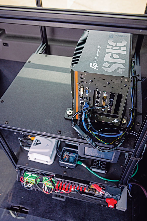
Hexagon | AutonomouStuff’s hardware rack inside the Ford Transit shuttle. (Photo: Hexagon | AutonomouStuff)
When it comes to ground transportation, most of the R&D regarding GNSS is aimed at developing driver-assist systems and, ultimately, driverless cars and trucks. For that purpose, GNSS receivers are integrated with inertial navigation systems, radar, lidar, computer vision and ultrasonics.
Leveraging decades of robotics experience and knowledge of control algorithms, AutonomouStuff, part of Hexagon’s Autonomy & Positioning division, has developed a software stack for autonomous vehicles based on the Apollo open-source software stack.
“Think of this software stack as a brain powering the autonomous platform,” said Kevin Fay, product manager for Hexagon’s platforms and vehicle software business. The software stack can be customized across platforms and to meet equipment needs.
Most recently, in a collaborative project with the National Advanced Driving Simulator at the University of Iowa, AutonomouStuff worked with the Automated Driving Systems for Rural America project to outfit a Ford Transit 350HD shuttle for autonomous operation. First, it created a drive-by-wire system that enabled electronic control of the vehicle, and then it installed positioning, navigation and perception sensors. The result is a platform ready to be autonomous as soon as the software stack is integrated.
Rural roads — which have a wider range of speeds than urban ones — may be encumbered by wildlife or heavy equipment. They also vary in surface from asphalt to gravel, providing a particularly challenging test environment for the autonomy software.
“The Iowa vehicle has done a sizable amount of automated driving on a combination of urban and rural roads, where traditional sensing falls flat,” Fay said. “It has excelled in areas such as gravel roads that have limited or no lane markings, or are narrower than normal. We deployed it earlier this year to do things such as traffic-light detection with the cameras on board, so that it navigates traffic-light intersections appropriately.”
While rural roads are generally free of the GNSS multipath challenges presented by urban canyons, they also provide fewer navigation landmarks. Another challenge is inclement weather. During snowstorms, Fay pointed out, country roads might be unplowed. “If you run on the right lane of the road all the time, you might be out of the ruts that are on the road, and then you’re struggling to get through.” The vehicle must learn to navigate appropriately in those conditions.
The University of Iowa Ford Transit shuttle is a limited deployment, mainly to collect data for research purposes. Meanwhile, it is giving real rides to residents, though with a safety driver. “They’re always attentive, but their hands will be next to the wheel,” Fay said. “There will be times where they may have to take over.”
Other universities and companies are using the platform to further their autonomy programs. Most of them are doing urban driving in complex routes with live traffic, for a total of a dozen vans nationwide.
Hexagon equips the vehicles with a variety of sensors, including a front-mounted adaptive radar, a roof-mounted Velodyne lidar, a roof-mounted NovAtel GNSS receiver and cameras mounted inside the vehicle. “Which ones we provide depends largely on the customer and on which software they’re deploying,” Fay said. “We provide our customers a complete package that can be used with minimal work out of the box. It has the software, the interface to the vehicle, and sensors on it. But we can also provide them with a vehicle that simply has an interface for control, and they add their own computer and software on top of it.”
Hexagon’s first Ford Transit was deployed in 2021. The company released the current version in the spring of 2022, and the Iowa project is slated to run through the middle of 2023. “We’ve not had something running in live traffic before,” Fay said, “so it allows us to continue to grow our skill sets and our overall expertise.”
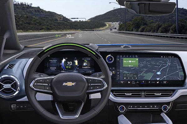
More than 34 million miles have been driven with Super Cruise engaged on General Motors vehicles. (Photo: GM)
General Motors and Trimble have reached more than 34 million miles of hands-free driving with Super Cruise engaged on General Motors vehicles.
GM teamed with Trimble to develop a reliable way to maintain in-lane positioning for hands-free driving, putting safety top-of-mind.
Trimble’s precise GPS technology enables a vehicle to maintain its lane position in a variety of environments, including inclement weather conditions (rain, snow, fog and more), which often challenges other sensors. GM’s Super Cruise, a hands-free driver assistance system, uses Trimble RTX (Real-Time eXtended) technology to deliver high-GNSS accuracy corrections since it introduced the technology in 2017 on the model year 2018 Cadillac CT6.
“Trimble RTX has been in commercial use for more than 10 years, and in 2018 was the first precise point positioning correction service to log miles in a commercial autonomous driving system,” said Patricia Boothe, senior vice president of Autonomy, Trimble. “It works with Super Cruise to help a vehicle maintain its lane position, bringing more consumers access to a more enjoyable and convenient driving experience.”
Standard GPS receivers can have a margin of error of up to 25 feet, which is not suitable for vehicles that require precise absolute position information to maintain lane-level positioning. Trimble’s RTX technology removes errors in GNSS satellite data broadcasts to improve location accuracy on our roadways.
“Super Cruise is a life-changing technology, allowing customers to experience hands-free driving on compatible, mapped roads nationwide,” said Mario Maiorana, GM chief engineer, Super Cruise. “The technology is a collaborative effort internally and externally to bring this advanced driver assistance technology to life. Trimble Autonomy has been a valuable collaborator in bringing Super Cruise to our customers.”
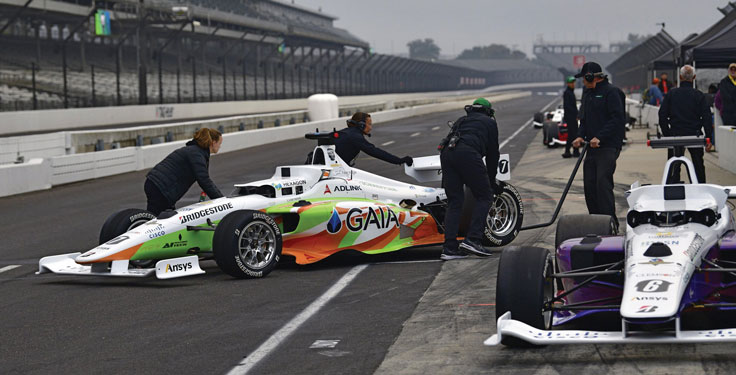
Flipping the traditional scenario, in which car racers risk their lives on a racetrack, the Indy Autonomous Challenge (IAC) aimed to help save lives by improving collision avoidance systems, train future automotive engineers, and make the public more comfortable with autonomous cars. Held Oct. 23 at the Indianapolis Motor Speedway and organized by Energy Systems Network, the race saw 21 universities from nine countries forming nine teams to compete for a $1 million grand prize. Following in the footsteps of the DARPA Grand Challenge, first held in 2004 and later renamed the DARPA Urban Challenge, the IAC was the world’s first high-speed autonomous race. The winning team was TUM Autonomous Motorsport from the Technical University of Munich, Germany.
All competing teams were given the same identical vehicle to work with, a Dallara AV-21, modified to carry no one in the cockpit and equipped with two Hexagon | NovAtel PwrPak7-Ds multi-frequency, multi-constellation GNSS receivers, six cameras (two of which faced backward), three lidar scanners and four radars. Each team had to develop its own autonomy-enabling software stack, including the algorithms and neural networks. All the components, except the computer, had to be commercial-off-the-shelf, available on the market. No sensors could be custom-made.
Since 2001, Dallara has been the sole supplier of the Indy Lights series, a championship to prepare drivers for the NTT IndyCar Series. The Dallara AV-21 is a collaboration between Dallara’s Italian headquarters in Varano Melegari (Parma) and Dallara IndyCar Factory in Speedway, Indiana. The new car offers a modern, stylish appearance and provides the proper training required for drivers as the final step on the ladder to the NTT IndyCar Series.
The process by which the automated vehicle sensors and computers were fused into a singular package and integrated into the AV-21 was led by Clemson University’s International Center for Automotive Research’s Deep Orange 12 (DO12) project. The Deep Orange process mirrors that of automotive original equipment manufacturers (OEMs), and the DO12 project scope allowed for engineering and innovation across multiple subsystems. Student groups within the DO12 team explored solutions within and across multiple subsystems, including:
vehicle-to-vehicle communications
perception systems
onboard computing
drive-by-wire chassis control systems
vehicle dynamics
vehicle-to-infrastructure communications
powertrain design and integration
vehicle demonstration based on high precision GPS.
Hexagon’s Autonomy & Positioning division provided GNSS receivers and subject-matter experts to the Deep Orange 12 team. The team architected the sensor kit for the Dallara reference vehicle, which AutonomousStuff then replicated 10 times. The team did not compete in the IAC to avoid a conflict of interest and allow students to work closely with competitor teams from universities around the world. The PwrPak7-E1 contains a MEMS IMU to deliver Hexagon | NovAtel’s SPAN technology, a deeply coupled GNSS + inertial engine in a single-box solution. Each GNSS receiver has two antennas to provide heading. The Deep Orange 12 team used HxGN SmartNet RTK corrections, which brought the accuracy down to a few centimeters.
Without developing a driverless decision-making algorithm, Clemson students tested the vehicle with the help of a high-precision positioning system. They developed a control algorithm that can track the optimal line around the Indianapolis Motor Speedway such that all vehicle systems could be validated in a simulated racing environment. Data from these tests were shared with the competition teams to aid in their development of driverless algorithms.
Energy Systems Network will host a head-to-head, high-speed autonomous racecar passing competition at the Las Vegas Motor Speedway on Jan. 7, 2022, during the Consumer Electronics Show. Several of the teams that competed in the IAC, including the winner and finalists, will participate. The primary goal is to advance technology to speed commercialization of fully autonomous vehicles and deployments of advanced driver-assistance systems.
TomTom has launched TomTom AutoStream, an innovative map delivery service for autonomous driving and advanced driver assistance systems. The first partners to use the technology — Baidu and Zenuity — were unveiled at the 2018 Consumer Electronics Show.
TomTom AutoStream enables vehicles to build a horizon for the road ahead by streaming the latest map data from the TomTom cloud. By ensuring that the map used to power advanced driving functions is always the latest, TomTom AutoStream enhances driver comfort and safety.
“The launch of TomTom AutoStream is a game-changer for OEMs and technology companies that are working on the future of driving,” said Willem Strijbosch, TomTom’s head of autonomous driving. “TomTom AutoStream allows vehicles to access the latest, most up-to-date TomTom map data for their driving automation functions.”
TomTom AutoStream is designed in a flexible way, allowing customers to customize the map data stream based on criteria such as sensor configuration and horizon length. It can stream a wide variety of map data including ADAS attributes such as gradient and curvature, and the TomTom HD Map with RoadDNA. This flexibility allows customers to use AutoStream to power a wide range of driving automation functions.
Strijbosch continued, “Our early investment in the TomTom advanced map-making platform means that we can continue to deliver revolutionary innovations like TomTom AutoStream. With TomTom AutoStream we can significantly simplify and shorten the development time for our customers, accelerating the future of driving.”
TomTom AutoStream ensures that the TomTom map data used to power advanced driving functions is the latest, most accurate available, enabling a safer and more comfortable experience.
“With AutoStream TomTom is offering an innovative map delivery system targeted at automated driving,” said Roger C. Lanctot, director, Automotive Connected Mobility for Strategy Analytics. “The development is targeted at helping automakers bring ADAS and autonomous driving functions to market faster.”
TomTom AutoStream will be available for production usage in 2018.
u-blox has provided global positioning technology to Cohda Wireless‘ vehicle-to-vehicle (V2V) and vehicle-to-infrastructure (V2I) equipment, collectively called V2X. V2X will be a key technology for the next generation of advanced driver assistance systems (ADAS) as well as autonomous vehicles, the companies said.
Cohda’s DSRC (dedicated short-range communications) based V2X system uses accurate satellite positioning with embedded dead-reckoning technology provided by u-blox. The system enables early warning of imminent collisions, oncoming traffic, the presence of road workers and unsafe speed based on vehicles in the vicinity.
“Cohda’s V2X DSRC-based solutions make full use of u-blox’ advanced automotive-grade positioning technology to enhance driver safety through ample warning time and excellent non-line-of-sight performance. Such technology will soon be a standard feature embedded in all vehicles,” said Michael Ammann, VP platform partnerships at u‑blox.
“Our V2X vehicle warning systems are dependent on highly accurate position and velocity data to deliver the performance that is crucial to meet the safety demands of next generation cars,” said Fabien Cure, Chief Engineer at Cohda Wireless. “u-blox’ satellite positioning solutions, leading automotive dead reckoning technology, module roadmap and clear strategy to deliver lane accurate performance in challenging urban environments was convincing.”
CSR has added significant upgrades to its SiRFDRive software dead-reckoning algorithms, improving automotive positioning performance and meeting the requirements of leading OEMs across the globe. This video demonstrates how these latest algorithms improves the overall performance in Chicago, once of the most challenging environments to obtain accurate vehicle positioning results.
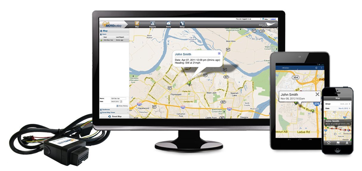
Agilis Systems, LLC, a provider of GPS-based software solutions for businesses, now offers MOTOsafety Teen Driving Coach — a specialty consumer product designed to help parents monitor location and driving behaviors of their teenage drivers.
According to the National Highway Traffic Safety Administration (NHTSA), inexperience and speeding are top contributors to teen automobile accidents. The team at Agilis recognized this as an opportunity to leverage the company’s experience improving safety ratings of professional drivers to develop a similar product that would help young drivers become better, safer drivers.
Expanding Agilis’ product line to include a consumer product that will help teens stay safer on the roads was an easy step to take, says Agilis Systems’ President and CEO, David Barford. “Most of us here at MOTOsafety are parents. I, myself, am the father of four children. I know the stress and worry you feel as a parent the first time you hand the keys to a new driver. So evolving our technology from business use to helping safeguard and teach our kids… absolutely. It was a must-do.”
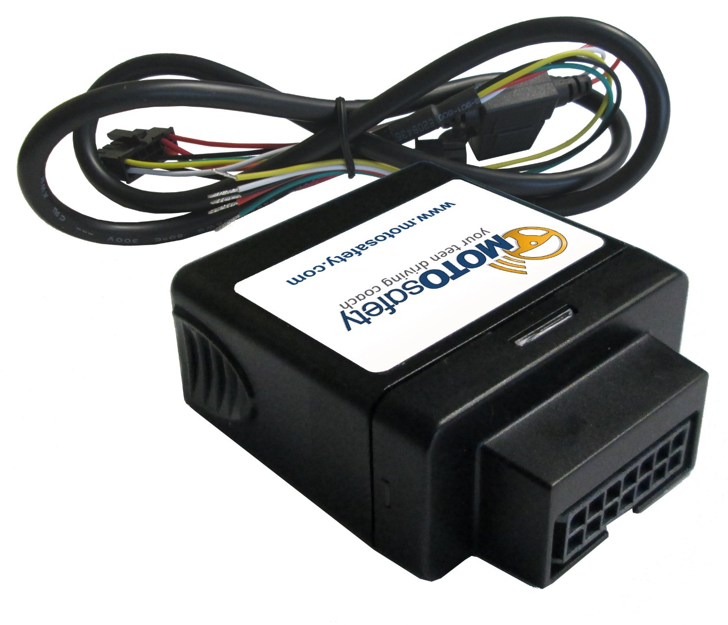
Photo: Agilis Systems
Agilis Systems developed MOTOsafety in collaboration with a former police officer and driving school owner and an advisory board of parents.
MOTOsafety was first offered to the public with a soft launch in 2011. Today, MOTOsafety is the largest and most trusted GPS teen-driving product on the market.
MOTOsafety is a web-based software and mobile app that provides parents with real-time and historical information on their child’s daily driving habits. Data is collected using a small GPS device that installs directly into the vehicle. Customers may choose between a removable plug-in tracker or a hard-wired option. Both devices are small in size, easy to install, and are not visible in most vehicles.
Parents login to secure web-based software to review daily reports on speed, rapid acceleration, harsh braking, routes traveled, and times and locations of driving activities. The MOTOsafety software also allows parents the option to set approved driving hours and designate geofences — customizable, virtual mapped boundaries where their child may or may not travel. Parents may also opt to receive real-time text or email alerts if their teen driver violates speed limits or other established rules, or if the MOTOsafety device is removed from the vehicle.
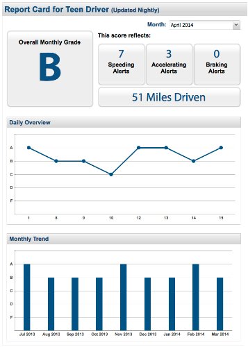
Another MOTOsafety feature is the Daily Driver Report Card. This specially designed report provides a summary of the prior day’s driving activity in a familiar letter-grade format. The Report Card is automatically emailed each day, and serves as a coaching tool for parents to review with their child and facilitate on-going conversation on his or her driving performance, safe driving practices, and goals for improvement.
Geotab, a telematics engineering company, is announcing its J1939 integration launch with Mobileye’s Advanced Driver Assistance System — the Mobileye 560. In combining these two solutions, businesses with heavy-duty fleets will be able to use advanced warning alerts to reduce the likelihood of vehicle crashes from occurring.
In addition to the reports provided by Mobileye and Geotab that target unsafe driving practices, the solution also provides lane departure warnings, forward collision warnings, pedestrian and bicyclist warnings, distance keeping (headway) warnings, and speeding alerts. The ultimate goal is to give drivers added visibility and insight in the unexpected moments they need it most.
Edward Kulperger, VP of Business Development for Geotab, commented on the cooperation by explaining that “fleet management technology has evolved to include proactive and dynamic solutions that incorporate real time data in the vehicle and in a fleet’s operations to predict and alert both safety and efficiency elements of fleets.” Isaac Litman, Mobileye Inc.’s CEO, Mobileye Aftermarket, said, “With Geotab, we have provided businesses with an unbeatable driver monitoring and evaluation system. It is the one of the most effective risk management tools available in the marketplace today.” This enthusiasm was also mirrored by Neil Cawse, Geotab’s CEO, “The ease in which businesses can adopt this technology makes it possible for fleet managers to show real savings that make an impact on the bottom line.”
According to Mobileye, fleets using this collision avoidance technology typically realize a return on their investment in about 6-8 months. The benefits are abundant: Safe driving habits are significantly improved, costs associated with accidents are reduced or completely avoided, smooth driving patterns are reinforced on a continuous basis, and fuel and maintenance costs are minimized. Geotab and Mobileye are working together to bring the solution to the global market.
Navevo specialists in satellite navigation solutions for heavy-goods vehicles (HGV) drivers, now offers the ProNav HGV Cyclist Alert. Supplied as standard on the new ProNav PNN420 satnav for truck drivers and soon to be rolled out across all current ProNav systems, the safety feature provides junction alerts at high convergence areas of trucks and cyclists and prompts drivers to take extra care.
The number of cyclists in London is on the rise, along with safety risks that arise when trucks and cyclists both are traversing busy London junctions and interchanges.
The ProNav HGV Cyclist Alert software was developed in association with Transport for London (TfL) to provide a commercial vehicle driver with an audible and visual alert as he or she approaches a junction (or section of road) that has been determined to be a location where there are high volumes of HGVs and cyclists. A warning symbol is displayed on the navigation system’s mapping that projects a 50-meter radius “warning zone” around each HGV/Cyclist convergence area. Drivers are also provided with a short audible tone as a reminder, giving the driver plenty of time to check for any cyclists on the road, Navevo said.
The HGV Cyclist Alert software uses data provided by TfL and the up-to-date Department for Transport HGV and pedal cycle flow figures for London’s road network. The dataset uses this information to identify locations where large numbers of HGVs and cyclists converge. Initially, 100 high-convergence areas across London have been included (alerts at every junction would be counterproductive to drivers). Working with other local authorities both in London and nationally, Navevo plans to increase the level of coverage and will provide free updates when new data becomes available.
“A navigation system is something a driver is likely to be listening to as they approach a junction, and so it makes perfect sense to also alert the driver of the risk of cyclists, reminding them to be observant and drive safely,” says Navevo CEO, Nick Caesari. “The safety of drivers, cyclists and other users of the road is a concern for everybody, and we are proud to lead the navigation industry by launching this ‘world first’ safety feature, which we believe could significantly contribute in improving road safety and reducing the number of incidents involving HGVs and cyclists.”
“For many years, London has worked to lead the way in pushing for the adoption of safer lorries and safer lorry driving,”
Ian Wainwright, head of Freight and Fleet at Transport for London. “The creation of a specific cyclist alert for HGV drivers is another positive step forward and will help to further raise awareness and improve cycle safety across the capital.”
A new technology to combat dozing off when driving is being developed by two universities with industry partner Ficosa. The drowsiness alerter, Somnoalert, is a smartphone application that uses inertial sensors and GPS data to detect movements that are characteristic of nodding off at the wheel, such as deviation from the driving lane or sudden corrections. A later prototype also incorporates biomedical sensors to analyze respiration data.
“One of the main causes of car accidents is drowsiness, especially on long highway trips,” explains Santiago. “Most monitoring systems developed in the last few years have been integrated systems that need to be connected to the car’s system. Our device combines our group’s expertise in sensors and biological data analysis with FICOSA’s vehicle know-how, and is completely portable.”
“Accidents related with drowsiness have a very high social and economical impact, that the key automotive industry players are facing as a whole, in order to reduce current accident statistics,” said Alan Montesi, who heads the project for FICOSA.
Most GPS devices in cars today give the driver two choices: shortest route or fastest route. GreenGPS provides a third option: most fuel-efficient route.
With gas prices skyrocketing, many drivers would be happy to spend a few more minutes on the road, or take a different route, if it meant burning less gas.
The answer could be the GreenGPS navigation service, now being developed by researchers at the University of Illinois at Urbana Champaign (UIUC), which finds the most fuel-efficient route for your vehicle.
“The most fuel-efficient route may be different from the shortest route because the latter may pass through downtown stop-and-go traffic,” explained Tarek Abdelzaher, project lead and computer science professor. “It may also be different from the fastest route because vehicles are not as fuel efficient at higher speeds.”
All cars manufactured in the U.S. since 1996 come with a standard interface to their internal gauges and engine measurements called the On-Board Diagnostics Interface, or OBD-II. GreenGPS runs on the driver’s GPS-enabled cell phone and uses an off-the-shelf wireless adaptor plugged into the vehicle’s OBD-II port to receive engine readings via Bluetooth.
The cell phone collects the readings and connects to a server that models the engine’s fuel efficiency and customizes navigation advice to the particular vehicle, Abdelzaher explained.
The best route computed by GreenGPS to the same destination may differ from one vehicle to another. “For example, my vehicle uses about 20-25 percent more gas in stop-and-go traffic compared to free-flowing traffic, whereas my wife’s car uses closer to 40 percent more,” Abdelzaher said. “GreenGPS may recommend to her a path that is longer but has no traffic, whereas it might recommend to me a path that incurs some traffic but is shorter.”
To users, GreenGPS looks like a regular navigation service. The driver specifies a destination, then ask the service to find a route. “It runs on your cell phone, except that in addition to the fastest and shortest route options, it offers the ‘least-fuel route’ option,” Abdelzaher said. “If the driver chooses that option, they receive the GreenGPS-recommended fuel-efficient route.”
The program works best with a small hardware addition to collect readings specific to the vehicle. “In order for the advice to be customized to the performance of your specific vehicle, the driver should invest in buying the OBD-II adaptor. It costs about $50 and is a one-time investment,” Abdelzaher said.
“If the driver does not wish to buy the adaptor, they can still use GreenGPS and supply the make, model, and year of their vehicle. In this case, GreenGPS will use data from other vehicles of the same make, model, and year, or vehicles as close to them as possible to compute the navigation advice,” Abdelzaher said. This social networking component is also being developed as part of the project.
The system pulls the GPS data from the driver’s cellphone. “If you use a GPS phone (and most smartphones have GPS), the system simply finds out your current location from your phone. Otherwise, you would need to supply both source and destination addresses (like you would when you get directions from Google Maps) and the system will show you the route on a map.”
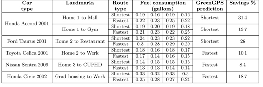
Gas-Saving Pilots. In the first stage of testing, the team solicited volunteers to drive in the area of their university, in Urbana-Champaign, a city of 170,000. In all, 1,000 miles were driven by 16 different cars. Results demonstrated that following the fuel-efficient route saves on average 6 percent over the shortest route, and 13 percent over the fastest. “This was done on flat terrain and in the absence of significant congestion,” Abdelzaher said. “We expect that testing in higher traffic and richer topology will increase the variability in fuel consumption among different routes, resulting in even more potential savings when following the most fuel-efficient route. Verifying this conjecture is currently a topic of investigation for our ongoing research project.”
Abdelzaher said his team has just started the second stage. “In the second stage of testing, we will deploy GreenGPS on the UIUC Facilities and Services fleet (about 100 cars) and monitor performance over a longer period of time. Preparations for this deployment are currently under way. We also expect to offer GreenGPS publicly to any other volunteers who wish to help with testing.”
Impressed by early findings of gas savings, the second phase is being funded in part by a $300,000 grant from the National Science Foundation. Abdelzaher and Robin Kravets, another UIUC computer science faculty member, were awarded the grant this spring. It will help deploy GreenGPS among the campus fleet cars, and track and analyze the results.
“By sharing data on speed, fuel efficiency, and location of vehicles, better real-time navigation services can be developed that guide drivers to routes that are maximally fuel-efficient for their cars, hence reducing transportation carbon footprint,” the grant reads. “This project helps usher in a new era of sensing applications with more integration of humans, networks, and the physical world, which may have a significant impact on the economy, energy, and the environment by reducing transportation energy cost and carbon footprint.”
Other grant providers are the Office of Naval Research, which is funding research on the technology’s networking component, and IBM through its Smarter Planet initiative. As a part of this project, 200 or more cars in the Urbana-Champaign area of various makes and models will be fitted with GreenGPS. Through a social network of drivers, data and routes collected can be shared and used by those who don’t have the OBM-II adaptor installed.
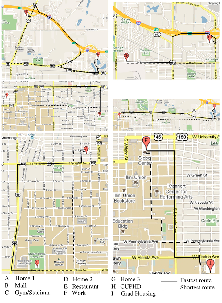
Fuel consumptions for the various roundtrips between different landmarks.The landmarks and corresponding shortest and fastest routes.
Today, some of the most exciting innovations in consumer electronics aren’t the ones in your living room or your office — they’re the ones inside your car. — Audi CEO Rupert Stadler
While most automobile magazines do a great job of reviewing the performance of automobiles and trucks, they do not adequately address the vehicles’ GPS or positioning, navigation, and timing (PNT) capabilities, sensors, or electronics suites. Nor do they endeavor to fully grasp how these sensor suites, many enabled by GPS and other PNT devices, add to their safety, peace of mind, and overall situational awareness. My pick of the best automobile currently on the market for driver situational awareness is the 2011 Audi A8.
Lest you think the choice was easy, it was not. For two years I drove more than 26 different candidate automobiles and I found myself repeatedly comparing them to the A8L. The Audi 8L is designated by its maker to premiere and test all electronic features — hardware and software, including situational awareness devices — that may eventually go into production on other Audi models.
I noticed when I began testing automobiles that, on the high end, they were fairly uniform in performance. The majority of them went from 0 to 60 miles per hour (0 to 100 kilometers per hour) in less than five seconds. They all stopped or went from 60 to 0 in approximately 100 feet (30.48 meters), depending on the tires, weather, and road surface. They were all reasonably quiet and to some degree comfortable. The average fuel mileage varied from 15 to 27 miles per U.S. gallon, with the Audi A8L taking honors in this class. However, the models varied tremendously in their electronic sophistication, integration, and situational awareness: some vehicles kept the driver situationally aware, and some failed miserably at this critical task.
I look not only at the electronics and how they are integrated, but also how easily and completely they inform the driver in all sorts of traffic and weather conditions. Do the windshield wipers activate automatically when it rains or you enter a fog bank? Does the navigation system automatically reroute you or at least offer that option when weather, accidents, or delays are encountered? Does the PNT system alert you in time to take evasive action in a potential dangerous situation? Does it present the mapping interface and alerts so that you are aware of your options both aurally and visually? Do you have to manually intervene or merely follow clear and precise directions?
Every major automobile maker and dealer I spoke with said that the majority of serious buyers today look for performance and style as always — but those have become secondary to the options provided, mainly the electronic awareness, safety, and entertainment suites. Of course, makers and dealers also appreciate the fact that these options, while adding safety, convenience and awareness, also add — often significantly — to the bottom line, or the vehicle’s drive-away price. So, yes, situational awareness does come at a price and sometimes a steep one. However, if it gives you peace of mind, lower stress, and saves lives, it is hard to complain. One can certainly make the argument that all these devices should be available on all automobiles. As time goes by they will be, and at a lower price. For now, we pay a premium for them. But what price can you place on a human life? Rest assured, many of these features are potentially life-saving.
Stealth GPS
I want to alert you to a phenomenon some GPS subject matter experts and I discovered while researching for the Department of Defense. It surprised us, but in retrospect we have always suspected the phenomena existed; we have chosen to call it Stealth GPS.
Stealth GPS exists in many military platforms today, and the practice now extends to the automotive industry as well. Basically, 90 percent of the more than 1 billion GPS users in the world use GPS for time or timing purposes and not for just position or navigational purposes. Obviously, in automobiles with very high-tech systems onboard, timing and synchronization are critical. Since GPS chips today are relatively inexpensive, they occasionally show up in unexpected places. No less than five major auto makers told us that every model they produce has a single and more likely multiple GPS chip(s) embedded somewhere in the electronic suites. These automobiles may or may not have a standalone GPS display, and it may not be obvious to the owner or even the mechanics that work on the vehicle, but GPS information, including timing data, is essential to proper vehicle operation.
For example, on the Audi A8L the Quattro sensors measure tire adhesion or slip up to 100 times per second and report that information through the traction-control system’s electronics. This requires precision timing and a tightly integrated timing or synchronization system.
Consider that GPS time is distributed freely around the world, and relatively cheap quartz crystal clocks can act to hold over precise GPS timing for a considerable period when the vehicle’s GPS antenna, also usually a stealth device, cannot see the sky. GPS chips in addition to position and navigation information may provide time of day to include day, month, year, hour, seconds, and divisions of seconds down to 1 x 10-14, along with altitude, attitude, heading, and velocity information, all independent of any other sensors on the car. As you will see, when GPS data are tightly integrated with other sensor data and display systems, the resulting displays and capabilities can be almost staggering in their versatility and ability to make the driver situationally aware.
How many GPS chips, stealth or otherwise, does the Audi 8L carry? Frankly, I am not sure, and it’s just possible that neither is Audi; after all, some of them are likely very stealthy. But regardless of how many there are, they inform and enable a dizzying array of displays, capabilities, and overall situational awareness second to none.
When I drove the A8L, every time I wanted a piece of information that the situation demanded, it always seemed to be readily available, and usually in more than one location. There is a pop-up full-color 8-inch display screen in the center console and a full color 7-inch display screen directly in front of the driver, between the speedometer and tachometer. The 7-inch screen is so well integrated that until information starts to appear, you never know it exists. I did not have to search or push buttons or pull levers — the information was simply there when I needed it.
The Audi’s displays were the most intuitive I have experienced to date. So much so that after experiencing the Audi’s non-intrusive total situational awareness capabilities, they were subsequently conspicuously absent on any other vehicles I drove.
The Audi A8L is available with all of what Car and Driver calls Audi’s latest “electronannies,” including a multimedia interface (MMI) and voice-controlled GPS display, which disappears when not in use or when the automobile is turned off. There is also active and adaptive cruise control with low-speed stop-and-go capability that will actually initiate and fully stop the vehicle if you are about to collide with an object, person, or another vehicle — and you fail to stop the car yourself.
The A8L has
a blind-spot monitoring system;
a camera-enabled lane-assist mode that turns on above 40 miles per hour and warns you with a steering wheel vibration when you are wandering in your lane or about to intrude on another;
a night-vision system that displays yellow silhouettes for anything warm-blooded ahead, including pedestrians and those lovable but pesky Bambis lurking by the side of the road; when such creatures are directly in the car’s path, the alerts turn bright red.
a visual reverse navigator in the center pop-up that clearly displays the exact parking path the car will take depending on how you turn the wheel. The proximity sensors beep with increasing frequency as you near objects and turn to a solid tone when you are within four inches of the object. I parked the Audi A8L several times solely by monitoring the center display.
While these wonders are merely enabled by GPS, the display screens in the vehicle are nothing short of amazing in their capability and versatility. The touch-screen color display can enable almost any feature of the automobile through a mere touch while many features are MMI- and/or voice-activated. You quickly learn, if your hands are occupied keeping you on the road, that you merely need to speak, and the Audi quickly obeys.
Road Trip
Before driving from Colorado Springs to Denver and back, I spent two very informative hours with the dealer staff going through the A8L’s features and capabilities. They do this with every prospective buyer — a good thing because the number of features can be daunting. But once you are actually driving, everything seems intuitive and, most important, non-distracting. I never once had to hunt for switches or buttons, because if you can’t remember, just use the audio system and tell the Audi what you want or need.
On the open road, I headed north to Denver. I set my destination merely by asking aloud for the Denver airport; the system immediately gave me a choice of the three airports in and around Denver, and I selected one. I could have looked up all airports within 100 miles, or put in the address if I knew it, or just browsed local transportation options, or even input the coordinates if I had them.
The center display always gave me the speed limit of the road I was traveling; it allows you to set a warning if you exceed that speed by your choice of number. The car is so quiet, there are no audible clues as to your actual velocity. If there had been any speed cameras on I-25, the Audi would have warned me about them as well.
The car always displayed the next three turns in blocks that clearly gave the mileage to the turn, the direction and degrees of the turn, and the name of the exit and road to turn onto. A mile before each exit, the navigation system displayed all its amenities and points of interest (POIs): gas stations, motels, hotels, restaurants, hospitals, and cash machines. It can display much more or less, depending on how you program, it, but the logos for the amenities show up just like they do on some road signs with the same information (although the road signs never seem to be there when you need them, or they go by too fast to read). Plus, both the center and driver’s panel displays show in bright vivid blue your route and the turns to make, the lane you should be in, and very accurate distances and times to the next turn, your final destination, and any intermediate points.
Wonder of wonders, when I turned off the prescribed route (on purpose), I never heard the dreaded “Recalculating…” The system adjusted and gave me new data to my destination based on my waywardness, and a pleasant suggestion to “proceed along the highlighted route.”
Back on I-25, all of a sudden yellow triangles appeared on both navigation displays, with a visual and audible warning of slow traffic ahead; a few seconds later came an indication that an accident had occurred. The nav system immediately zoomed out to show alternate routes with major thoroughfares that would take me around the slowdown. I took the first turn off the Interstate without making any manual adjustments to the system. It routed me effortlessly around the accident and back to I-25. I never pushed a button or had to ask a question. If I’d wanted to continue on secondary roads, it would have accommodated that automatically.
On the outskirts of Denver, I programmed the system to find the nearest Starbucks, which was less than a half-mile off the Interstate. There I reprogrammed my return route to go through seven POIs. Having accomplished this feat without once looking at a manual, I was off again.
I made the trip back on secondary roads mainly so I could cruise with both sun roofs open and listen to the 19 speakers of the wonderful Bose stereo system (Bang and Olufsen option). I stayed about 5 miles below the speed limit and was passed innumerable times, but I didn’t care because I was having so much fun. This automobile is so comfortable, you find yourself looking for ways to extend your journey: 22-way adjustable leather seats; five-way, five-intensity massage system, automatic seat heating/cooling.
I made it to all seven POIs, including a couple I had heard of but never visited before, because of the frustration of getting lost trying to find them. Before I was ready, I found myself back at the dealership. The excellent staff encouraged me to keep the car longer, but frankly I was afraid if I did, it would wind up in my garage, and that is just not in the budget right now. That reminds me, I need to ask for a raise.
Bluetooth connectivity is available; the Apple iPhone can be fully controlled and/or downloaded onto the A8’s terabyte hard drive and accessed from any of the three color touchpad screens in the car.
You can control the GPS navigation interface to include new destinations, from the full color 10-inch touch screens in the rear passenger compartment, giving new meaning to the phrase “back seat driver.” There is a single DVD-CD drive slot in the center dash console as well as a six-disk changer unit in the optionally refrigerated glove box. That is, if the large cooler that extends into the rear cabin from the trunk space is not enough for you. Understandably, the rear cooler is a bit hard to reach from the front seat while you are barreling along the Autobahn at 130 miles per hour, or down I-25 at 75.
Information Everywhere
Bottom line for the Audi A8L: the information you need is displayed almost everywhere you look, and can be called up with the touch of a button, the scroll of a finger, or the sound of your voice. All internal and external data is provided in an atmosphere that is second to none climatologically and ergonomically. It is the only automobile I have driven lately with four full-color touchscreens that, while keeping you situationally aware no matter where you are seated, can simultaneously control all the systems in the automobile. The two 10-inch rear-seat screens can be used to read e-mail, browse the Internet, or watch the latest movies or television programming. Add to this an incredibly performance-minded vehicle, the highest gas mileage rating in its rank, amenities that want to make you slow down and enjoy the journey, and you have my pick for the best GPS-enabled, situationally aware vehicle in its class.
Thanks to Vince Cimino, general manager at the Phil Long Audi dealership in Colorado Springs, and his staff for unfettered access to the Audi A8L and all their expertise.
Until next time, happy navigating.
Burkhard Hunhke, executive director of Volkswagen Group’s Experimental Research Laboratory: “We are now able to keep up with and even surpass the technology in mobile devices.”
Interview with Audi Research Director Burkhard Huhnke
While testing Audis for this article, I had the opportunity to interview Dr. Burkhard Huhnke, executive director of the VW/Audi Experimental Research Laboratory (ERL) in Palo Alto, California. Palo Alto is also home to Stanford University, and thus to Stanley and Shelley, autonomous vehicles that have driven into the record books. ERL supports all brands within the Volkswagen Group: Audi, Bentley, Bugatti, Lamborghini, Seat, Skoda, and Volkswagen.
The integration of external and onboard capabilities with GPS and a screamingly fast new Nvidia Tegra 2 chip make the Audi navigation system the first in-car navigation system with 3-D display capabilities.
Don Jewell (DJ): How is this integrated GPS different from a mobile device adhered to the windshield?
Burkhard Huhnke (BH): Let’s say the driver is overwhelmed in a very difficult situation, like approaching a traffic jam in bad weather at high speed. The Audi will sense this — we call it pre-sense — alert the driver, begin a series of automatic safety measures, such as tightening the seatbelts and closing windows, and then automatically start to brake the automobile. For us, the systems in the Audi are for more than just displaying information or blinking warning lights. The systems actually take over some of the functions and support the driver, especially in emergency situations. GPS provides a way for us to localize the car in its environment with data such as time of day, weather and traffic conditions, and any other information that both onboard and external sensors, such as the Internet and Google, connected provide.
DJ: What happens when GPS data is not available?
BH: We must provide additional sensors and train our systems to learn to bridge the time with GPS outages or interruptions without the driver being aware that GPS is no longer being received, make it seamless. The intelligence, the metadata from other sensors is onboard in the embedded systems, and they are programmed to provide the necessary data when GPS is not available.
DJ: How does this translate to a better experience for the customer?
BH: We put a lot of effort into the optimization of the human-machine interface (HMI). We have psychologists working on the HMI along with our designers and programmers. Some car manufacturers provide systems that force you to think like an engineer to operate them. We realized this approach won’t work. To create an intuitive navigation system requires much, much more. It requires input from our customer, what is intuitive to them. For this as I said we use simulators, customer inputs, along with psychologists, clinical studies, and a great deal of effort that goes into understanding what makes a truly intuitive interface and a system that people will like and enjoy using.
You do not need a handbook to operate our systems. I actually hate handbooks and I believe that if you cannot figure out how to do something, such as program a destination into a GPS in just a few seconds, without a handbook, then the customer will not like it; so we purposely made the system intuitive and very user friendly. The learning curve is very short and our customers find themselves using the system in no time at all.
We found out one of the key things our customers want is beautiful, high-definition, and fast graphics. So we started working with one of the leading companies (Nvidia) for graphical interfaces. In the end, we created an environment in the Audi A8 that is more like your home living room than a normal automobile.
In the A8 we combined the Internet and the onboard Audi network with things like Google Maps so you can continuously download Google Maps as they are needed: beautiful high-definition color graphics and maps with connectivity. The POI search is absolutely as up-to-date as it can be, often including data updated the same day or possibly just a few minutes before from the Internet. In the A8 for a POI you get the same information as if you had searched on your computer at home.
DJ: How much do you care about accuracy for your GPS/PNT systems in the Audi? Is one meter enough?
BH: We are extremely interested in a very accurate GPS position down to the centimeter level. Not all manufacturers are. Since you live in Colorado you may have heard about the Audi TT that successfully drove autonomously up Pikes Peak. To do this, we used differential GPS signals to take hairpin turns at race-like speeds.
But we realized that it is a risk to only depend on external signals such as GPS. GPS information is critical, but we find ourselves depending more and more on our onboard sensors. This gives us a huge advantage, such as with our onboard camera system. It gives us the ability to develop better adaptive cruise-control functions. All these extra sensor inputs combined with GPS gives you the best precision, but when you don’t have GPS, you have to rely on other sensors to take over.
We launched a navigation system with a processor from Nvidia at the same time it was announced as a capability in a mobile device. In the past, we were always behind the time with technology because we were conservative with what we put in the cars, but with this move we are now able to keep up with and even surpass the technology in mobile devices. We created a very smart motherboard so we can exchange and process data quickly.
DJ: What do you see as your mission?
BH: Producing the safest car in the world, and I think we are there. The United States still has 37,000+ traffic fatalities every year, so we took it as our responsibility to create the safest systems onboard any automobile. Our new navigation system predicts curves and safe speeds for the conditions and sometimes automatically reduces the speed of the automobile. We talk a lot about driverless cars, but actually I think we all enjoy driving, like you do, Don, with your Q7 in the snow in Colorado. But there are also times when we are extremely bored and not paying attention to our driving and just wish we could press an autopilot button and start answering e-mails or something. This could be in a traffic jam or any circumstance where it is no longer fun to drive. So that is something we would like to accomplish.
Recently we created a new program with Stanford University to work on solutions for mobility challenges. We want to be able to obtain more external information, use onboard information, and create the car of the future with the smart people at Stanford and those of us at ERL. We want a navigation system that is smart and can predict traffic, which helps and supports the driver, and therefore makes driving extremely safe. That is now our mission.