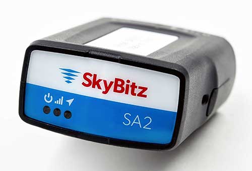
SA2012 offers customers configurable GPS tracking device on the latest 4G network
Photo: SkyBitz
SkyBitz has launched the SA2012, equipped with the latest 4G LTE with 3G fallback, positioned for the light- to medium-duty vehicle tracking market.
With the option to purchase a range of price packages with configurable feature sets, the SA2012 is designed for customers looking for a scalable vehicle telematics solution they can use to increase profit margins and satisfy customer demand.
The hardware can be installed using the Ops Center mobile device, either directly plugging it into the vehicle diagnostic port or covertly installing it behind the dashboard, depending on customer preference.
Once installed, the device feeds into the SkyBitz Ops Center platform, where users can manage the new device alongside all others via a single interface. Customers will have coverage across North America, including Mexico and Canada.
The basic package includes GPS location data and estimated odometer and engine hours. With several options leading up to the Pro package, SkyBitz offers a variety of location, engine, and safety data that can be selected based on the customers’ operational goals and budget.
Customers can configure their solution with minimal training, adding features such as advanced alarms and notification schedules and over-the-air upgrades when future features are released.
“SkyBitz strives to bring the latest technology to market that meets industry demand but also exceeds our customers’ expectations. This is one more device added to the SkyBitz product line that is now delivered on the latest network, and integrated into the SkyBitz Ops Center platform so customers can easily see vehicle and asset data on one dashboard,” said Debbie Sackman, senior product manager with SkyBitz. “This device targets small and medium businesses and offers a flexible package choice where customers can add additional features with OTA upgrades as their business grows.”
Kratos Defense & Security Solutions, a developer of advanced unmanned system technologies, has teamed with Royal Truck & Equipment, which builds Truck Mounted Attenuator (TMA) vehicles and highway safety systems, to deploy the Autonomous Truck Mounted Attenuator (ATMA), a self-driving work zone vehicle. The ATMA is an autonomous vehicle that uses driverless technology.
According to the company, highway workers are routinely placed in high-risk situations, but are at especially high risk when assigned to drive a TMA vehicle. The TMA vehicle, also known as an Impact Protection Vehicle, is a truck that follows behind slow moving highway maintenance vehicles as a human-driven mobile crash barrier absorbing the impact of traffic accidentally entering the work zone.
“Driving a TMA is extremely dangerous and drivers are at serious risk of lifelong injury, painful rehabilitation and even death,” said Maynard Factor, business development director at Kratos Defense. “To eliminate this dangerous assignment, Kratos Defense developed the Autonomous TMA (ATMA) by retrofitting standard TMA vehicles with driverless technology to enable unmanned operation.”
The first ATMA systems were deployed in 2017 and have since then been deployed across the United States and Europe. The unmanned ATMA operates in a multi-vehicle leader/follower configuration with a human driven highway maintenance vehicle, the companies said. In the leader/follower configuration, the system enables the maintenance vehicle (leader) to transmit navigation data via encrypted V2V communications to the ATMA (follower). From there, the ATMA uses the data to follow the leader, unmanned, as it travels along the route.
The ATMA systems features component redundancy, an active safety system, high accuracy GPS/GPS-denied navigation, encrypted V2V communications, and multi-modal front and side-view obstacle detection, the companies added. It also includes a user interface that provides system feedback, situational awareness, multi-camera views and operator controls.
“Highways are becoming increasingly dangerous due to distracted drivers texting, following too closely, falling asleep, etc., and work zone fatalities from traffic-related crashes average in the hundreds per year,” Factor said. “Our main goal in developing the ATMA was to increase worker safety by removing them from behind the wheel of a vehicle deployed for the sole purpose of operating as a crash barrier.”
Kratos Defense & Security Solutions will be exhibiting at AUVSI’s Xponential 2019 at booth #226.
Teletrac Navman, a global software-as-a-service provider that leverages location-based technology for GPS tracking solutions, has launched its fully integrated Driver Safety Analytics Solution.
Part of the Teletrac Navman Director platform, the safety analytics solution combines GPS tracking data and event replays, dashboard camera technology, driver scorecards and analytics on a single platform so fleet managers have all the information needed to reduce risks and implement safe driving practices across their fleets, the company said.
“I have a full view into safety and the solution makes everything fact-based. Before I had perceptions of how my drivers behave on the road, but now I have proof,” said customer Bonnie Lantz, director at P&B Transportation. “I can see training needs and, of equal importance, our drivers’ incredible defensive driving when cars around them behave erratically. Our insurance company and drivers both wanted the cameras, and I expect it will save us money and give our whole fleet a better grasp on safety.”
The Director Safety Analytics module provides insight into driver-specific and fleet-wide behavior to create a safety-focused culture, recognize and retain great drivers, and improve the insurance claims process. Features include:
The Integrated Event Viewer lets fleets simultaneously view driving event replays and unsafe behaviors on Google Maps, using GPS tracking data, and second-by-second Dashboard Camera video footage for quick response to and resolution of incidents.
Front-Facing Dashboard Cameras continuously record HD quality video footage, with recordings of all events stored in the cloud. In addition to getting a complete picture of events, footage can be used as supporting material in the event of an insurance claim and to protect against driver fault in accidents.
Driver Scorecards track and rank driver improvements over time for personalized training, in combination with event replay and live footage, and to recognize positive driver behaviors.
Reporting & Alerts measures speeding, harsh breaking, erratic cornering and other dangerous behaviors through GPS tracking and proactively alerts fleet managers. It lets fleet managers build dashboards around safety KPIs and do in-depth evaluation on fleet-wide and individual driver safety performance to easily communicate performance trends, create targeted improvement plans and build incentive programs that encourage safe driving.
“We built this solution to give fleets absolutely everything they need to build a culture of safety,” said Daren Lauda, general manager of North America, Teletrac Navman. “The high-level fleet benchmarking is easy to drill down into to understand how individual drivers are performing. Add in the integrated telematics and corresponding video footage and fleet managers have a complete, real-life picture of safety to fuel individualized training, track progress and protect their drivers in incidents.”
SmartDrive Systems has introduced the SmartDrive SmartChoice Program, a video-based safety program that provides fleets the freedom to choose the level of video protection that best aligns with their specific business priorities and needs.
Whether the company’s primary objective is exonerating drivers from frivolous claims or preventing collisions with 360-degree visibility to risk, SmartDrive’s SmartChoice Program offers a product line to meet each fleet’s requirements. The new SmartDrive Shield and SmartDrive Defender, in conjunction with SmartDrive Assurance, offer flexibility in video-based safety by providing a program allowing users to start now and upgrade at any time with existing hardware.
“With our SmartDrive SmartChoice Program, we put choice squarely in the hands of our customers, ensuring every fleet now has a better way to protect its drivers with video,” said Steve Mitgang, CEO of SmartDrive, “We understand that a video safety program needs to fit the culture of the individual fleet. With three video-safety product lines and our distinctive open platform, SmartDrive’s SmartChoice Program lets fleets decide what they need, how best to deploy video within their operation and when the time is right to scale their investment, by moving up to a more comprehensive solution as their requirements expand.”
With the SmartDrive SmartChoice program, fleets can choose from among three product lines, each with unique capabilities and benefits, as described below:
SmartDrive Shield — A road-facing camera combined with on-demand video offload and easy-to-use review workflow, SmartDrive Shield is designed for fleets that have owner operators or are not yet ready for integrated coaching, and are focused on capturing every collision, exonerating when not at fault and providing drivers the ability to record issues on the road, such as delivery verification and security incidents.
SmartDrive Defender — Configurations of up to two cameras offer road-facing and cab views, with automatic video offload, risk scoring and integrated coaching. SmartDrive Defender is designed for fleets that want to protect every driver by identifying high-risk incidents — including speeding, lane departure, hard braking and collisions — and provide proactive coaching to reduce collision frequency, improve safety and reinforce good driving skills.
SmartDrive Assurance — Deployment of up to four cameras enables a 360-degree view of the vehicle and insight into the most frequent causes of collisions — such as U-turns, backing, unintended lane changes, roll-overs and close following — delivering a high level of coverage and complete visibility to risk. SmartDrive Assurance is designed for fleets focused on maximum protection and prevention of safety and compliance-related incidents.
The SmartDrive multi-tiered video-based safety program identifies unsafe driving with an extensible platform, integrating video, vehicle data, audio and driving data for a unified and comprehensive view of risk. The SmartDrive SmartChoice Program offers unmatched flexibility for fleets with a wide range of priorities, while ensuring that companies’ investments in video solutions are protected and can evolve as their operational needs change and technology advances.
Fleets that previously felt video safety didn’t fit their driver or operational environment now have an option with SmartDrive Shield, a no-coaching, road-facing only solution focused on exonerating drivers in not-at-fault collisions. When ready for an integrated safety program, fleets can easily move to SmartDrive Defender or SmartDrive Assurance, leveraging the same flexible video analytics platform.
“With our SmartChoice Program, it’s all about letting fleets decide what’s best for them, in terms of onboard system integration, how many cameras they incorporate, what type of risk they want to measure, and how or if coaching is part of their operations,” emphasized Mitgang. “SmartDrive Shield, Defender and Assurance not only reduce collisions, but also save fleets time and resources, which can then be focused on delivering increased value to their customers through on-time delivery, accuracy and better overall service.”
Geotab, a telematics engineering company, has released its IOX-CAN extender, a plug-and-play solution that allows partners to send data from their device over a private CAN network in the vehicle, supporting integrations on all vehicle types.
Geotab is exhibiting at Mobile World Congress 2015, at Hall 3, Stand 3J20.
According to Geotab, Fortune 500 companies, including 40 percent of the top ten fleets and 18 percent of the top 100 fleets in North America, rely on Geotab’s solutions to improve productivity, optimize fleets through the reduction of fuel consumption, enhance driver safety, and achieve stronger compliance to regulatory changes.
A number of companies are already leveraging the IOX-CAN extender to send data from their devices to the MyGeotab system. Geotab’s integration with Mobileye, a technology company that develops vision-based Advanced Driver Assistance Systems (ADAS) providing warnings for collision prevention and mitigation, has been upgraded with the IOX-CAN extender allowing full support for all vehicle types, including OBDII (on-board diagnostics II) vehicles.
Geotab’s new add-on solution allows Mobileye devices to plug into Geotab’s GO6 and GO7 devices, allowing Mobileye data to be sent to the MyGeotab software platform, where it can be viewed and analyzed by dispatchers and fleet managers.
“Our solutions are designed to make the roads safer for everyone as the issue of distracted driving continues to be a problem,” said Elad Serfaty, vice president and general manager of Mobileye Aftermarket. “Working with Geotab allows us to not only provide feedback to the driver, and with managers who can effect change where needed, but we can do this across all vehicle types.”
“Expanding our integration capabilities and continuing our work with Mobileye is a natural evolution as more and more companies realize the benefits of fleet management,” said Neil Cawse, CEO, Geotab. “Providing collision warnings to drivers just before a crash is the first step to creating a safer driving environment for everyone.”
Editor’s note: Dennehy is GPS World’s editor for location-based services, writing a monthly column for the LBS Insider newsletter. The views expressed are his own. He will be covering the Mobile World Congress in Barcelona for GPS World. Contact him at [email protected] with your news.
Sen. Ed Markey’s new car technology report, released earlier this month, basically says that connected vehicles can be hacked, causing danger to drivers and presenting major privacy concerns. While some critics believe Markey’s report was meant to drive media hysteria, others say it raises serious issues that the industry needs to address. In other location news, I’ll be covering the Mobile World Congress in Barcelona for GPS World. What will be the showcased location technology? Wearables? Connected vehicles? Or something new?
Kevin Dennehy
By Kevin Dennehy
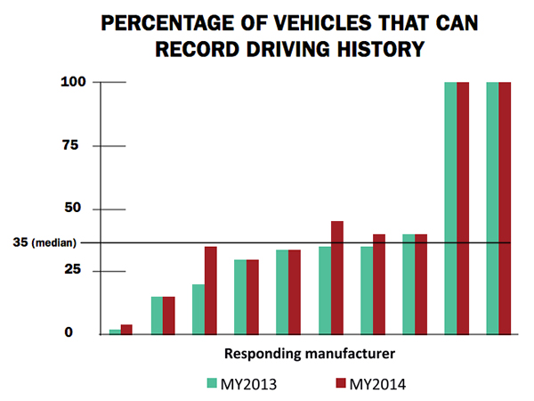
A report released by Sen. Edward Markey (D-Mass.) earlier this month says that even though drivers have come to rely on new connected technologies, automakers haven’t done their part to protect them from cyber attacks or privacy invasions
First reported by CBS News’ 60 Minutes, Markey’s report, Tracking & Hacking: Security & Privacy Gaps Put American Drivers at Risk, includes information from 16 automobile manufacturers who were given questions about security and privacy. However, few of the carmakers’ answers included how vehicles may be vulnerable to hackers — and what driver information is collected.
Location industry veteran Kim Fennell, deCarta CEO, said the report should be a real concern to the industry. “But it’s more of an issue for autonomous driving and the security of the car’s electronic control system. Even today, the OnStar service, which was a pioneer in the connected car space, can remotely slow your vehicle down in the event of a theft,” he said. “This feature, if hacked, could definitely create massive problems if the proper security technologies are not implemented.”
Markey’s report raised additional concerns about the use of navigation and other features that record and send location or driving history information.
Fennell said there should be a distinction between the infotainment systems in the vehicle and the on-board control systems of the car.
“We believe that there should be a strict firewall between these systems so that nothing malicious can happen that is initiated from the connected infotainment system. Any data should flow one way — from the control system of the car to the infotainment system,” he said. “This is not to say that the connected infotainment system shouldn’t be secure, it should be. In working with our OEM and Tier One partners, we have implemented strict security protocols between our servers and their apps.”
Markey’s report found that “[automakers] use personal vehicle data in various ways, often vaguely to ‘improve the customer experience’ and usually involving third parties, and retention policies — how long they store information about drivers — vary considerably among manufacturers.”
In addition, the report found that customers are often not made aware of data collection and, when they are, they often cannot opt out without disabling features, such as navigation.
Percentage of Vehicles that can record driving history
Overall, Fennell hopes that the most malicious thing that could happen in the event of a hack of an infotainment system is that a “Pandora station is changed to play nothing but Justin Bieber songs, the traffic information for your route is projected to be ridiculously long or the Yelp rating of the restaurant that you are going to is lowered down to one star.”
Ultimately though, the driver should be in control of the car and nothing in the infotainment system should affect the behavior of the vehicle, Fennell said.
In terms of driver safety, in a recent survey, deCarta found that more than two-thirds of respondents considered dashboard screens that display videos and other Internet content to be the most dangerous types of onboard information systems. Approximately 79 percent of those polled preferred “voice-activated mapping systems that allow drivers to keep their eyes on the road” as an essential safety-enhancing feature.
“There are two things that infotainment systems could do better to prevent driver distraction. First, instead of replicating the stove-piped app store environment of the smartphone, in-car infotainment services could be better integrated,” Fennell said. “If I find a destination on Yelp, I’d like to send that to my navigation system instead of typing in the address. Second, with today’s better automated speech-recognition technology and text-to-speech engines, it’s now possible to make requests of your infotainment system using natural language commands. Voicebox is doing some great things in this area.”
Fennell said that most existing systems are not connected. “But those that are, aren’t predictive enough. Your navigation/infotainment system should almost work as a concierge,” he said. “It should recognize what time it is and realize you are most likely leaving for work and offer up the best route based on traffic conditions. It should recognize that you are going to a destination in an urban area and offer the most convenient parking to your destination.”
Company Rolls out Indoor Positioning Product that Doesn’t Require Retailer Involvement
After testing and demoing the product in San Francisco last year, IndoorAtlas is rolling out a consumer app called GPSindoor, which uses smartphones to locate shoppers inside a mall. The product features product proximity advertising to allow shoppers to see where they are relative to a product for promotion marketing.
The product includes a crowdsourcing function to allow user-generated data to build indoor maps, wayfinding and other options for shopping promotions, said Wibe Wagemans, IndoorAtlas president.
“We don’t need any retailers per se. We need only the shopper and [their] smartphone,” he said. “There is no brand or retailer involvement if you use our app. Unlike Wi-Fi and Bluetooth beacons, since GPSindoor relies on a community of shoppers, it allows for higher accuracy than static maps. That gives us the confidence to take on the giants like Apple Beacons and Google Indoor Maps head on — we are completely independent of retailers and not dependent on them for our success in becoming the GPS of indoors.”
In other location news:
HERE released a new version of its mapping system for Android, saying it made significant improvements. According to the company’s blog, after more than 3 million downloads, it is shedding the “beta” label with this version. In the beta version, when users asked for a route, the app gave them three car routes. If a user wanted public transit or pedestrian routes, they had to switch to the appropriate tab. This process was slow and inconvenient for people who don’t use a car all the time, HERE said.
In its recent financial statements, Garmin indicated a growing, and profitable, segment is its wearables/fitness band product line. Mio is also expanding its wearable offerings. This should be a big topic at next months’ Mobile World Congress.
I’ll be covering the Mobile World Congress in Barcelona for GPS World. Contact me at [email protected] with your news.
u-blox has provided global positioning technology to Cohda Wireless‘ vehicle-to-vehicle (V2V) and vehicle-to-infrastructure (V2I) equipment, collectively called V2X. V2X will be a key technology for the next generation of advanced driver assistance systems (ADAS) as well as autonomous vehicles, the companies said.
Cohda’s DSRC (dedicated short-range communications) based V2X system uses accurate satellite positioning with embedded dead-reckoning technology provided by u-blox. The system enables early warning of imminent collisions, oncoming traffic, the presence of road workers and unsafe speed based on vehicles in the vicinity.
“Cohda’s V2X DSRC-based solutions make full use of u-blox’ advanced automotive-grade positioning technology to enhance driver safety through ample warning time and excellent non-line-of-sight performance. Such technology will soon be a standard feature embedded in all vehicles,” said Michael Ammann, VP platform partnerships at u‑blox.
“Our V2X vehicle warning systems are dependent on highly accurate position and velocity data to deliver the performance that is crucial to meet the safety demands of next generation cars,” said Fabien Cure, Chief Engineer at Cohda Wireless. “u-blox’ satellite positioning solutions, leading automotive dead reckoning technology, module roadmap and clear strategy to deliver lane accurate performance in challenging urban environments was convincing.”
Agilis Systems, LLC, a provider of GPS-based software solutions for businesses, now offers MOTOsafety Teen Driving Coach — a specialty consumer product designed to help parents monitor location and driving behaviors of their teenage drivers.
According to the National Highway Traffic Safety Administration (NHTSA), inexperience and speeding are top contributors to teen automobile accidents. The team at Agilis recognized this as an opportunity to leverage the company’s experience improving safety ratings of professional drivers to develop a similar product that would help young drivers become better, safer drivers.
Expanding Agilis’ product line to include a consumer product that will help teens stay safer on the roads was an easy step to take, says Agilis Systems’ President and CEO, David Barford. “Most of us here at MOTOsafety are parents. I, myself, am the father of four children. I know the stress and worry you feel as a parent the first time you hand the keys to a new driver. So evolving our technology from business use to helping safeguard and teach our kids… absolutely. It was a must-do.”
Photo: Agilis Systems
Agilis Systems developed MOTOsafety in collaboration with a former police officer and driving school owner and an advisory board of parents.
MOTOsafety was first offered to the public with a soft launch in 2011. Today, MOTOsafety is the largest and most trusted GPS teen-driving product on the market.
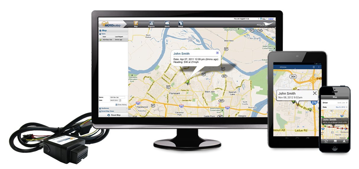
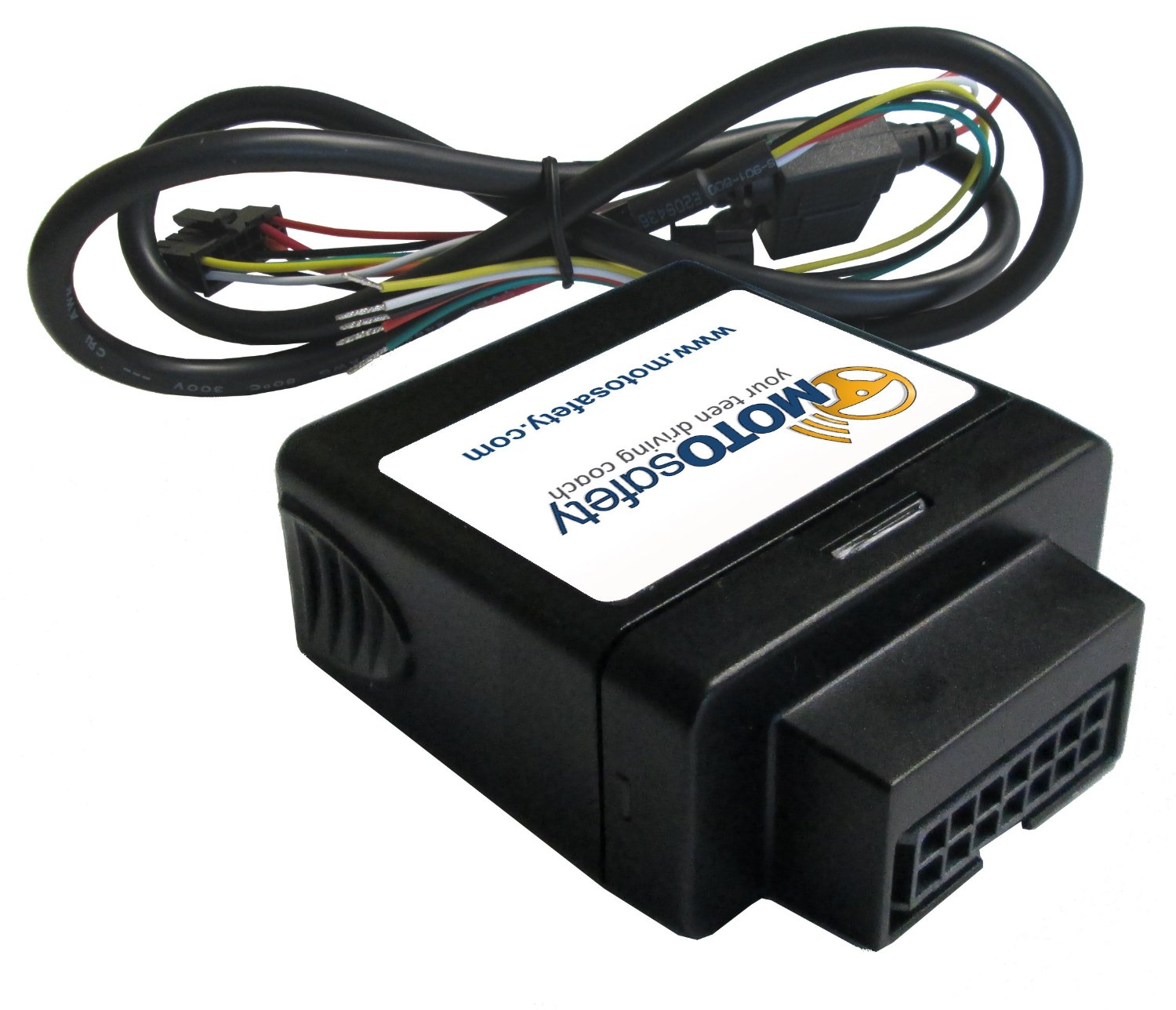
MOTOsafety is a web-based software and mobile app that provides parents with real-time and historical information on their child’s daily driving habits. Data is collected using a small GPS device that installs directly into the vehicle. Customers may choose between a removable plug-in tracker or a hard-wired option. Both devices are small in size, easy to install, and are not visible in most vehicles.
Parents login to secure web-based software to review daily reports on speed, rapid acceleration, harsh braking, routes traveled, and times and locations of driving activities. The MOTOsafety software also allows parents the option to set approved driving hours and designate geofences — customizable, virtual mapped boundaries where their child may or may not travel. Parents may also opt to receive real-time text or email alerts if their teen driver violates speed limits or other established rules, or if the MOTOsafety device is removed from the vehicle.
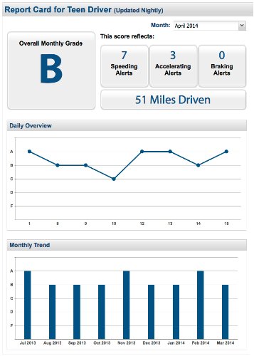
Another MOTOsafety feature is the Daily Driver Report Card. This specially designed report provides a summary of the prior day’s driving activity in a familiar letter-grade format. The Report Card is automatically emailed each day, and serves as a coaching tool for parents to review with their child and facilitate on-going conversation on his or her driving performance, safe driving practices, and goals for improvement.
When comedian Larry Wilmore started out Day 2 at CTIA Super Mobility Week by reporting from a connected car on the show floor, he was only half joking when he said, “It’s almost like you’re driving in a smart phone, and with smart phones getting bigger it’s not too far off. I think I saw an HTC this size.”
The experts in the keynote Connected Car panel agreed: The car is the new smart phone.
Just ask Ralph de la Vega, CEO of the just-formed AT&T Mobile and Business Solutions Group, who called the Chevy Corvette “the best smart phone I’ve ever gotten to test.” The Corvette was conveniently displayed next to the stage, along with a connected Tesla Model S.
As CTIA CEO Meredith Atwell Baker pointed out, what was once relegated to the CTIA show floor is now in dealerships all across the U.S. The statistics thrown out by de la Vega supported this observation. Thirty-two percent of new cars sold globally (and 60% of new cars sold in the U.S.) by 2017 will be embedded with cellular technology. Seventy-two percent of people would delay a new car purchase one year to buy a connected car by their preferred automaker.
De la Vega co-moderated the panel with Glenn Lurie, his successor as CEO of AT&T Mobility. Panelists representing General Motors/OnStar, Ericsson, VoiceBox and Tesla overwhelmingly agreed that the emphasis on the connected car going forward has to be safety.
“[Drivers are] trying to fill the time and be productive. People naturally want to do that. They’re going to bring the phone in, reach over, grab it and try to do things. And the more capabilities, the more they’ll do it,” said Mike Kennewick, co-founder & CEO of VoiceBox, maker of natural language technology. “It’s imperative as we bring the Internet into the car, there’s a component that allows you to do it safely.”
What that would mean, exactly, though, was a matter of opinion. Each panelist had a chance to discuss their company’s recent and coming advancements.
De la Vega says AT&T’s studies show people prefer a shared family data plan that would allos them to share data across people and across devices, and a belief by the wireless provider that customers should be able to add their cars to their rate plans.
GM has successfully integrated 4G/LTE into 33 different models in the U.S. and Canada and next plans expansion in Europe, Mary Chan, President of Global Connected Consumer at GM shared.
VoiceBox’s Kennewick calls the voice recognition in cars today “just like the movies” but says VoiceBox strives to simplify the apps in cars and make voice activation less about reiterative command-and-control.
Telsa, a leader in over-the-air auto updates, will be launching a mass market car “in a few years” and is now exploring how best to keep the customer experience focused in the car. Tesla CIO Jay Vijayan also said the company is considering opening up its infotainment stystem to other partners.
GPSTrackIt.com has introduced a new Driver Safety Alert that tracks hard turns. Driver Safety Alerts already track and report driving behaviors like rapid acceleration, hard braking, and seatbelt usage. GPSTrackIt engineers have now added the ability to identify “hard turns” to the alert list.
Driver Safety Alerts are used by businesses across the country to help dispatchers and managers understand how drivers are doing in the field. Businesses ranging from small-to-medium sized service companies to large transportation companies with fleets of hundreds of vehicles are able to help drivers understand the importance of safe driving behaviors.
“Drivers represent their employers to the public,” said Eddie Bermudez, GPSTrackit.com’s product development manager. “A vehicle that is driven badly or, more to the point, dangerously, does not reflect well on that employer. These alerts notify managers and dispatchers via email or SMS text messages when their drivers are driving in a potentially aggressive manner.”
Rapid acceleration and hard braking are indicators of bad driving behaviors that also impact a vehicle’s mileage. Seat belt alerts indicate that the vehicle is moving while the driver’s seat belt is unfastened. Statistics show that wearing a seatbelt dramatically reduces deaths and injuries from collisions.
“Hard turns are another driving behavior that puts the driver and vehicle at additional risk,” continued Bermudez. “It also puts additional wear on a vehicle. We were able to utilize the accelerometer and gyroscope technologies built into the GPS tracking devices in a similar manner to the hard braking alert.”
According to the National Transportation Highway Safety Administration’s 2008 report to Congress, “National Motor Vehicle Causation Crash Survey,” about 36 percent of vehicles involved in collisions were turning or crossing at intersections just prior to the crashes.
“When we’re making a turn, we become more vulnerable,” added Bermudez. “Clearly in a left turn situation you’re putting your vehicle in the path of oncoming traffic. But right turns can be hazardous as well to both pedestrians and drivers. Turn too soon and you clip the curb, which doesn’t do much for your wheel alignment. Turn too late and you could end up making a wide turn. If the device on the vehicle transmits a hard turn event, Fleet Manager checks if an alert is configured for that vehicle. If so, it sends the time, date, and location information to the email and/or text recipients.”
Navevo specialists in satellite navigation solutions for heavy-goods vehicles (HGV) drivers, now offers the ProNav HGV Cyclist Alert. Supplied as standard on the new ProNav PNN420 satnav for truck drivers and soon to be rolled out across all current ProNav systems, the safety feature provides junction alerts at high convergence areas of trucks and cyclists and prompts drivers to take extra care.
The number of cyclists in London is on the rise, along with safety risks that arise when trucks and cyclists both are traversing busy London junctions and interchanges.
The ProNav HGV Cyclist Alert software was developed in association with Transport for London (TfL) to provide a commercial vehicle driver with an audible and visual alert as he or she approaches a junction (or section of road) that has been determined to be a location where there are high volumes of HGVs and cyclists. A warning symbol is displayed on the navigation system’s mapping that projects a 50-meter radius “warning zone” around each HGV/Cyclist convergence area. Drivers are also provided with a short audible tone as a reminder, giving the driver plenty of time to check for any cyclists on the road, Navevo said.
The HGV Cyclist Alert software uses data provided by TfL and the up-to-date Department for Transport HGV and pedal cycle flow figures for London’s road network. The dataset uses this information to identify locations where large numbers of HGVs and cyclists converge. Initially, 100 high-convergence areas across London have been included (alerts at every junction would be counterproductive to drivers). Working with other local authorities both in London and nationally, Navevo plans to increase the level of coverage and will provide free updates when new data becomes available.
“A navigation system is something a driver is likely to be listening to as they approach a junction, and so it makes perfect sense to also alert the driver of the risk of cyclists, reminding them to be observant and drive safely,” says Navevo CEO, Nick Caesari. “The safety of drivers, cyclists and other users of the road is a concern for everybody, and we are proud to lead the navigation industry by launching this ‘world first’ safety feature, which we believe could significantly contribute in improving road safety and reducing the number of incidents involving HGVs and cyclists.”
“For many years, London has worked to lead the way in pushing for the adoption of safer lorries and safer lorry driving,”
Ian Wainwright, head of Freight and Fleet at Transport for London. “The creation of a specific cyclist alert for HGV drivers is another positive step forward and will help to further raise awareness and improve cycle safety across the capital.”
Researchers at Israel’s Ben-Gurion University of the Negev (BGU) say reveal that data culled from geosocial networks like the GPS traffic app Waze can help prevent traffic incidents with better deployment of police resources at the most accident prone areas.
“Only now are we beginning to discover the potential in the huge amount of data collected daily,” explains BGU researcher and Ph.D. student Michael Fire. “Studies of this kind, which monitor events such as traffic accidents over time, can help the police identify dangerous sections of roads in real time, or alternatively, locations where few police are needed.”
The paper, “Data Mining Opportunities in Geosocial Networks for Improving Road Safety,” was presented at the IEEE 27th Convention of Electrical and Electronics Engineers in Israel.
Waze records location data and enables users to upload and share comments on any detail, including traffic alerts, accidents or police presence. According to its website, Waze has 30 million worldwide users and describes itself as “a community-based traffic and navigation app whose users share real-time traffic and road info, saving time and gas money.”
Using Waze data and Google Earth, the BGU researchers determined that three-quarters (75 percent) of the locations in Israel with the highest number of accidents were intersections. They then analyzed references to a police presence to determine if the police were present at the spots that had the worst traffic accidents.
“There were numerous instances where the police were manning quieter intersections, while busier intersections went unmonitored,” Fire explains. “According to the data, police response time varied from 20 minutes to 40 minutes in some situations.”
Using Waze, data from May and June 2012 was collected and analyzed on accident reports, police presence, traffic jams, and speed traps. BGU researchers identified 579 different locations in Israel that had at least five reoccurring accidents during this time where 5,156 reported accidents occurred. Police were reported at least 15 times at more than 3,500 locations.
Other researchers involved with the study from BGU’s Department of Information Systems Engineering and BGU’s Telekom Innovation Laboratories include Prof. Yuval Elovici, head of the lab, as well as Dr. Rami Puzis, Prof. Lior Rokach as well as student Dima Kagan.