Tag: drone camera

  • UAVs monitor marine emissions, string powerlines

    UAVs monitor marine emissions, string powerlines

    A couple of interesting drone applications came up this month — marine smoke emission monitoring and studies from a little known European drone manufacturer.

    Monitoring marine emissions

    Climate change: Some might say these are words we don’t really need to hear. Such a big to-do about how much human activity is affecting the weather changes that we are now seeing globally. Or is it all part of a natural cycle that the Earth is going through as many might say?

    I don’t really want to get into that argument, but it would seem useful that someone is doing something to reduce the use of dirty fuels by ships. After all, we seemed to readily acquiesce to unleaded fuel for our vehicles without a lot of protest; why would we accept this as the norm when marine transport still uses dirty bunker fuel, belching out a significant amount of pollution?

    If it’s good for people and their cars, and we quite possibly incurred some costs getting there, why not stick it on the marine industry too?

    So that’s what the International Maritime Organization (IMO) did in January this year, reducing the allowable sulphur content in marine fuel from 3.5 to 0.5%. Enforced under the international convention for the prevention of pollution from ships, this is aimed at cutting sulphur oxide emissions from ships by 77%, equivalent to a reduction of about 8.5  million metric tons annually.

    That’s the tricky bit – enforcement. Ships spend most of their time miles away from land, so knowing what their smoke emissions contain is somewhat difficult. Now (this is where I manage to tie things back to what I’m supposed to be reporting on) its useful that Schiebel, along with its partner operator Nordic Unmanned, thought about enforcement of the new regulations.

    Schiebel Camcopter S-100. (Photo: Schiebel)
    Schiebel Camcopter S-100. (Photo: Schiebel)

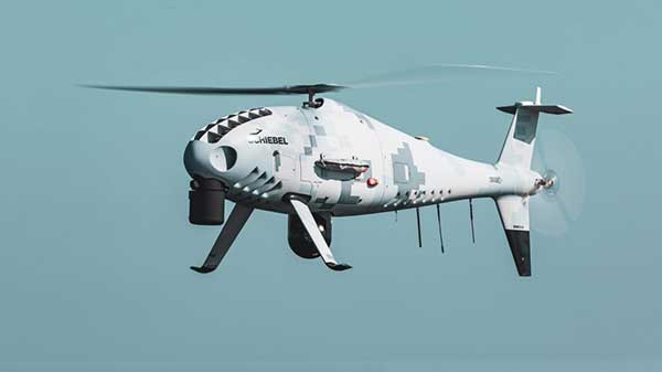
    With a range of up to 200 kilometers (~125 miles) the Camcopter S-100 can get out to the shipping lanes to check on what’s coming out of the smokestacks. Equipped with an automatic identification system (AIS), a sulphur sniffing sensor and an L3 Harris Wescam MX-10 real-time electro-optical/infrared (EO/IR) camera, the “enforcement drone” can determine which ship it’s flying over, what the smoke plume sulphur content might be, and even take geo-coded pictures to show in which jurisdiction the ship is sailing. If necessary, it can even take pictures of who’s throwing what at the overflying UAV.

    In recent tests, the Camcopter flew out of Gniben, Denmark, where European regulations on emissions applied, and marine exhaust fumes are limited to contain no more than 0.1 percent sulphur oxide. The Camcopter S-100 performed two 4- hour flights and provided real-time readings of the sulphur level in ships’ exhaust plumes.

    With these successful tests in the bag, Nordic Unmanned has indicated its capabilities to worldwide maritime authorities that they are ready and able to help enforce the new IMO regulations.

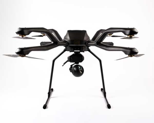
    European-built multi-rotor drone

    Acecore Technologies in the Netherlands makes multi-rotor drones which have found some unique applications:

    The NEO 8-rotor UAV. (Photo: Acecore)
    The NEO 8-rotor UAV. (Photo: Acecore)

    Stringing power-lines using NEO (SPIE website)

    In order to extend power transmission line capacity, the approach used is often to first pull a lead cable. This  normally involves several power company personnel and a whole bunch of specialized equipment.

    However, in a first-of-its-kind test, SPIE Nederland used an Acecore NEO drone to pull a lead cable over 150 meters between high-voltage pylons.

    Equipped with suitable cameras and other sensors, Acecore drones have also been used for power-line and gas-plant thermal inspection, movie making (including Game of Thrones), live broadcasts, autonomous aerial surveying, and tethered security applications. They also make crop health monitoring possible.

    Designed with durability in mind, Acecore drones are weather-proof, built with strong carbon-fiber frames, have triple redundant autopilots, and are ADS-B-ready to broadcast GPS position to support sense-and-avoid capability.

    Acecore is also promoting the fact that its drones and controllers are manufactured entirely with European parts. In other words, they would like to grab a chunk of DJI’s huge market share by jumping on an apparent global move to switch over from Chinese sourced goods and equipment.

    So, drones are taking on environmental monitoring. They’re reducing the environmental impact of transmission-line build-out. And they’re moving  toward building drones locally — all are interesting new applications of unmanned aircraft systems.

    Tony Murfin
    GNSS Aerospace

  • MicaSense offers Altum 3-in-1 sensor for ag drone mapping

    MicaSense offers Altum 3-in-1 sensor for ag drone mapping

    The Altum is a 3-in-1 sensor that combines thermal, high-resolution and multispectral imaging capabilities in one sensor. (Photo: MicaSense)
    The Altum is a 3-in-1 sensor that combines thermal, high-resolution and multispectral imaging capabilities. (Photo: MicaSense)

    The Altum sensor, offered by MicaSense, is designed for professional-grade agricultural drone mapping by enterprise and academic researchers. The Altum captures synchronized multispectral and thermal imagery, enabling aligned outputs for advanced analytics.

    Altum’s multispectral imagers are the highest resolution integrated multispectral solution available for drones, allowing for detailed RGB outputs and advanced crop classifications.

    Whereas before they had to fly multiple flights with multiple sensors, researchers, growers and service providers can now capture data for plant health, water stress mapping, phenotyping and more in one flight, with one sensor.

    The Microsense RedEdge-MX sensor aboard DJI's M210 RTK drone. (Photo: MicaSense)
    The Microsense RedEdge-MX sensor aboard DJI’s M210 RTK drone. (Photo: MicaSense)

    “The Altum design resulted from experience developing advanced analytics and understanding needs for advanced research,” said Justin McAllister, CTO and co-founder of MicaSense. “We realized the market is limited by time and cost constraints of owning multiple sensors and flying multiple passes over the same field. The goal of Altum is to simplify the workflow, and with synchronized capture, to provide results that can be correlated and quantified more easily.”

    Altum includes MicaSense’s standard five-band configuration of multispectral bands (red, green, blue, near-infrared and red-edge) and an integrated Lepton radiometric thermal longwave infrared sensor from FLIR Systems, providing temperature measurement for every pixel of the scene for additional crop data and optimization.

    https://youtu.be/Kdim4uol7S4

    Expandable high-capacity USB 3.0 storage allows users to fly longer and cover more area without landing to swap storage. In addition, advancements in image capture rate enables faster flight speeds.

    Users can process Altum data with industry standard software like Agisoft and Pix4Dmapper to generate an aligned, radiometrically calibrated six band (R, G, B, RE, NIR, T) geotiff, or access the raw data from Altum to process data themselves.

    Included with Altum is DLS 2, the patent-pending next generation of the MicaSense Downwelling Light Sensor (DLS). DLS 2 allows for a more streamlined integration as it combines both the DLS and GPS into one product. In addition, through proprietary MicaSense technology, the DLS 2 will offer significantly better calibration for changing light conditions and better measurements over time.

    Integrated solutions

    Altum’s multiple interface options and open API gives users the ability to utilize Altum on a variety of platforms. In addition to the DJI SkyPort integration, Altum is integrated with drone offerings from the following companies (with more to come):

    • North America: Drone Nerds (U.S.), BirdsEyeView Aerobotics (U.S)., OmniView Tech (Canada), Sky Flight Robotics (U.S.), Blue Skies Drone Rental (U.S.)
    • Europe: 3D Target (IT), Globe Flight (DE), C-Astral (SI), Droneparts.de (DE), Ecobotix (DK), NaviGate (PL), Quantum Systems (DE)
    • Asia: Cybernetech (Japan), Shenzhen Qianhai Yaqi Technology (China)

    DJI Payload SDK Program: Altum and RedEdge-MX for DJI M200 Series

    Through DJI SkyPort, MicaSense is able to provide seamless integration of its specialized sensors with DJI’s powerful line of enterprise drones, resulting in the MicaSense Altum and RedEdge-MX solutions. This provides users a high-quality drone and sensor combination they can rely on to capture quality data every time – with virtually no set-up time.

    The DJI SkyPort integration for Altum and RedEdge-MX features plug-and-play integration for Altum and RedEdge-MX right out of the box, including power and quick connect/disconnect, and enhanced light calibration with MicaSense DLS 2.

    “Solutions like the MicaSense Altum and RedEdge-MX demonstrate the value of integrating specialized industrial payloads to DJI’s powerful drone platforms,” said Jan Gasparic, head of Enterprise Partnerships at DJI. “By collaborating with solution providers, we are expanding the benefits of drone technology to more and more industries. In the case of agriculture, a specialized suite of sensors and more advanced level of analytics can truly bring tangible value to business workflows and decision making today.”

    The Altum and SkyPort enabled RedEdge-MX and Altum are available today through the MicaSense website.

  • Phase One launches cameras, lenses for UAV-based aerial imagery

    According to Phase One Industrial, the iXM 100MP is a high-productivity metric camera with a range of high-resolution lenses. Photo by Allison Barwacz

    Phase One Industrial has launched the iXM series, an aerial camera platform driven by its fast medium-format imaging sensor.

    Engineered for UAV-imaging missions, the iXM 100MP is a high-productivity metric camera with a range of high-resolution lenses. It is ready for integration with various UAV platforms, including Phase One’s DJI Matrice 600 Pro solution.

    The iXM 100MP metric camera incorporates the first medium-format sensor with backside-illumination technology, enabling high light sensitivity and extended dynamic range. Fast, highly responsive, robust and weatherproof (IP53 compliant), the iXM 100MP delivers superior quality aerial imaging and flexible operation to satisfy diverse mapping, surveying and inspection applications, the company said.

    In addition, Phase One announced four new specially developed RSM lenses — with focal lengths ranging from 35mm to 150mm — to seamlessly fit the new sensor’s 3.76 μm pixel size and 33 x 44 mm frame size, ensuring image sharpness across the entire FOV. The lenses are available with either fixed-focus or motorized-focus functionality.

    The fixed-focus 35mm and 80mm lenses provide superior image radiometric quality, high ground resolution and large coverage, suitable for surveying applications.


    The motorized-focus 80mm and 150mm lenses are designed for a wide range of inspection applications, including electricity poles, wind turbines, bridges, and other private-sector or government structures.

    Motorized-focused lenses, having no external moving parts, enable a number of new uses for inspection applications where the focusing distance can be predefined based on flight planning, or by the operator, using a wireless remote control. With the motorized lens, the camera captures sharp and highly detailed images of multi-distance or 3D objects.

    The cameras’ RSM lenses incorporate a new leaf-shutter technology, which supports 3 fps capture — with a speed of 1/2500 sec — while guaranteeing 500,000 actuations. The lenses are thermally stable to ensure consistent focus over a wide range of temperatures and flight altitudes.

    With optics designed to exploit the full benefits of the new sensor technology, the lenses provide with greater productivity, flexibility and reliability, offering superb image quality.

    The new iXM platform adds XQD high-speed storage technology to handle the sensor’s extremely fast frame rate. Also on all cameras, HDMI output from actual exposure provides UAV operators simple and outage-free feedback of actual view, exposures, and camera status in overlays.

    In addition, the new platform includes USB-C and 10G Ethernet for versatility of connectivity to large UAVs and aircraft.

    “Working with our UAV partners, we see a fast-growing market driven by great potential for time and cost savings over traditional inspection and surveying methods,” said Dov Kalinski, General Manager of Phase One Industrial. “With its new technology, design, and capabilities, the iXM 100MP promises to help start a new era in inspection missions with UAVs. Phase One Industrial continues to push technical boundaries to equip drones and larger UAVs with superior imaging technology — engineering advanced systems, cameras, and software — to help achieve that potential.”

    The iXM 100MP and iXM 50MP metric cameras are available for advance order  from Phase One Industrial partners worldwide  with delivery in June 2018.