Skyward, a Verizon company, has announced its integration with Pix4D, a photogrammetry software suite for drone mapping. The partnership gives customers the ability to turn drone data into 2D maps and 3D models.
Enterprises and drone pilots can now plan flights, receive approval to fly in controlled airspace with LAANC, fly with Skyward’s InFlight ground control station, and process data using Pix4D — all from within the Skyward platform.
“Skyward has been bringing our customers tools to access airspace, plan and fly — now they can produce business-ready data deliverables without leaving Skyward,” said Mariah Scott, Skyward president. “Enterprises in construction, energy and utilities, and the public sector can get even more ROI out of their drone programs when combining Skyward’s drone management platform with Pix4D’s market-leading photogrammetry tools.”
Skyward Mapping & Modeling, powered by Pix4D, enables customers to create, view, measure, and export 2D orthomosaic maps and 3D photogrammetric models right from Skyward’s web app. With the processing power of Pix4D, Skyward customers can get business-ready data sets through a seamless plan, fly, process workflow.
“Enterprises are seeking to scale their drone operations and transform their businesses with better data and faster time to insight. Skyward’s platform, along with the power of Pix4D, delivers a powerful, comprehensive solution,” said Christopher Cressy, Pix4D managing director for North America.
To learn more about Skyward’s mapping and modeling features, join a webinar on June 8 at 2 p.m. ET. Enterprises and commercial operators can try Skyward Mapping & Modeling powered by Pix4D free for 30 days.
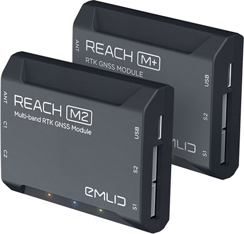
Emlid is offering two positioning modules for mapping with unmanned aerial vehicles (UAVs). Both the Reach M+ and Reach M2 provide centimeter-level accuracy in real-time kinematic (RTK) and post-processed kinematic (PPK) modes, enabling precise UAV mapping with fewer ground control points.
The Reach M+ single-band receiver has a baseline up to 20 kilometers in PPK. The Reach M2 is a multi-band receiver with a baseline up to 100 kilometers in PPK.
Usually autopilot triggers the camera and records the coordinate it has at that moment. When the drone is flying at 20 m/s and GPS works at 5 Hz, the UAV autopilot will have position readings only every four minutes, which is not suitable for precise georeferencing. In addition, there is always a delay between the trigger and the actual moment the photo is taken.
Reach solves this problem by connecting directly to the camera’s hot-shoe port, which is synced with the shutter. The time and coordinates of each photo are logged with a resolution of less than a microsecond. Reach captures flash sync pulses with sub-microsecond resolution and stores them in a raw data RINEX log in the internal memory. This method allows ground control points to be used only to check accuracy.
The Reach RS2. (Photo: Emlid)
The Reach M2 PPK UAV mapping kit consist of the Reach M2 multi-band GNSS receiver onboard the aircraft that records the location of each photo at a frequency of 20 Hz. It is combined with the Reach RS2 GNSS multi-band receiver on the ground, drastically reducing the number of ground control points and simplifying the setup process on site, while maximizing the accuracy to centimeter levels even in remote areas.
The M2 tracks GPS/QZSS (L1, L2), GLONASS (L1, L2), BeiDou (B1, B2), Galileo (E1, E5) and SBAS (L1C/A), and receives a fixed solution almost instantly.
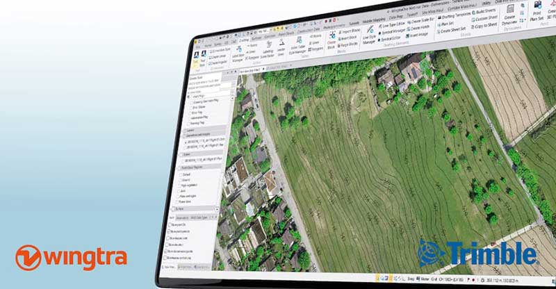
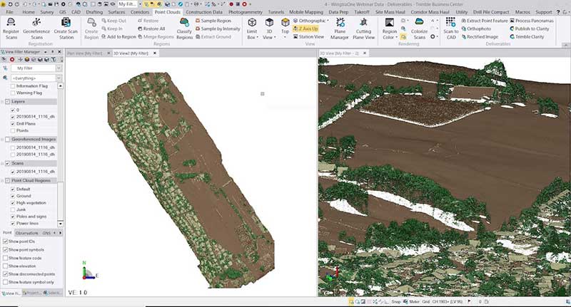
With Wingtra’s latest software release, surveyors and geospatial professionals can now directly import WingtraOne drone data into the Trimble Business Center (TBC).
According to Wingtra, the new integration seamlessly combines WingtraOne high-accuracy drone data within TBC, optimizing drone mapping workflows for survey and construction projects within a single software platform.
The integration allows users to drag and drop data into the software suite. Automated point cloud tools, such as classification and feature extraction, can then be used to quickly generate surface models, topographic plans and as-built deliverables.
Photo: Wingtra
“It’s a solid step forward to enable our data to work smoothly with Trimble Business Center,” said Francois Gervaix, Wingtra’s geospatial expert. “TBC is a reference software in the industry, because of its success as a data hub for construction and geospatial workflows. Optimizing the workflow lets TBC users smoothly integrate data from the fastest drone data capture platform on the market — WingtraOne.”
This latest Wingtra software release that introduced JobXML (TBC file format) compatibility also brought various other product updates. Namely, high-altitude flight capabilities, longer flight times and more intuitive battery level readings in-flight, Wingtra added.
The Skyfish platform is controlled by the tiny SkyNode computer, which integrates with optical, thermal, navigational and lidar devices along with sensors, algorithms and robotics. (Photo: Skyfish)
UAV technology developer Skyfish has introduced a computing platform for commercial drones that fully automates crucial infrastructure inspection and measurement tasks.
The Skyfish platform was unveiled and is being demonstrated at Booth #133 at the Commercial UAV Expo Americas conference being held Oct. 1-3 in Las Vegas.
Skyfish supports DJI and PixHawk flight controllers and other popular drone architectures, as well as 3D modeling software from companies such as Bentley Systems Inc.
Skyfish provides a smarter platform so anyone can fly, inspect and model complex infrastructure with an easy-to-use interface, the company said. The platform also pre-processes the collected infrastructure data and metadata to help create impeccable 3D models.
Available now to selected early-adopter customers, the Skyfish platform comprises:
SkyNode. Application-specific, onboard microcomputer controls the Skyfish system (and any Pixhawk 2.1 or DJI A3-based airframe.)
SkyControl. Flight planning software that facilitates the creation and execution of complex flight plans in a few clicks.
SkyFish Smart Gimbal. Delivers precision angle measurement with encoded motors to capture deep, highly accurate metadata for 2D mapping and 3D modeling.
SkyFish M6 or a DJI Commercial Drone. An expandable and collapsible commercial-grade UAV.
“The Skyfish platform represents a sea change in commercial drone technology for infrastructure inspection, measurement and analysis,” said Mike Barkasi, project manager at Bentley Systems. “For our infrastructure customers that want to enable the benefits of drone sourced data — but need engineering grade accuracy for their 3D modeling — I believe leveraging both the Skyfish and Bentley platforms together is a good answer.”
“As a leader in the unmanned aerial system (UAS) industry since 2013, Vision Aerial’s been waiting for a well-designed, autonomous solution that provides both precision navigation and built-in sensor integration,” said Shane Beams, CEO at Vision Aerial. “Skyfish delivers exactly that.”
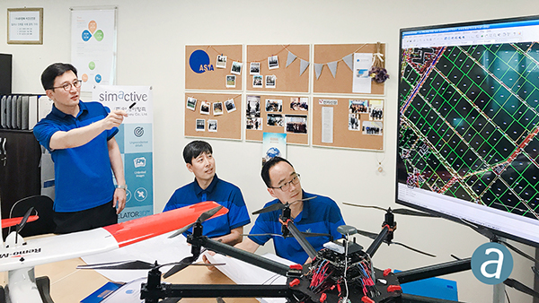
SimActive Inc., a developer of photogrammetry software, has enabled the first government drone mapping project in South Korea.
Asia Aero Survey (AAS), a SimActive regional partner, used Correlator3D for the public survey delivered to the Korean National Geographic Information Institute (NGII) and the Korean Association of Spatial Information, Surveying & Mapping.
While such projects were previously conducted using manned aircraft, a drone was preferred because of the difficulty in accessing the area of interest through traditional aerial and ground surveying methods.
The NGII officially published guidelines for public surveying and mapping with drones in March 2018, with the AAS project being the first delivered and accepted as adhering to the new guidelines.
AAS is also deploying UAV solutions with hyperspectral and lidar for other projects in conjunction with SimActive software.
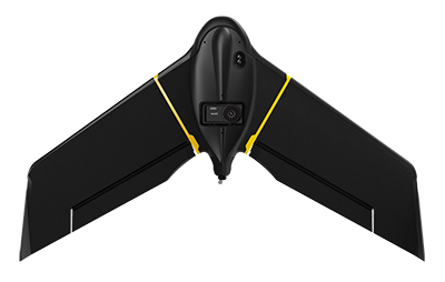
SenseFly, provider of fixed-wing drones, has launched the eBee X for mapping.
The eBee X, part of the Parrot Business Solutions portfolio, is designed to boost the quality, efficiency and safety of an operator’s geospatial data collection.
The eBee X. (Photo: senseFly)
It offers a camera to suit every job, the accuracy and coverage capabilities to meet the requirements of demanding projects, and is durable enough to work virtually every site, the company said.
“The eBee X is a giant leap forward for mapping technology and underscores senseFly’s position as the leader in the fixed-wing drone market,” said Gilles Labossière, executive vice president and COO of Parrot Group and senseFly CEO. “No matter what type of project a professional is undertaking, the eBee X has the coverage, data and accuracy capabilities needed to get the job done.”
The eBee X includes a range of cameras for jobs ranging from land surveying and topographic mapping to urban planning, crop mapping, thermal mapping, environmental monitoring and more. Cameras include:
The senseFly S.O.D.A. 3D: a unique drone photogrammetry camera with a one-inch sensor, which changes orientation during flight to capture three images (two oblique, one nadir) every time, instead of just one, for a much wider field of view. The result is stunning digital 3D reconstructions in vertically-focused environments—such as urban areas, open pit mines and coastlines—over larger areas than quadcopter drones can achieve. senseFly S.O.D.A. 3D is optimised for quick, robust image processing with Pix4Dmapper software.
The senseFly Aeria X: a compact drone photogrammetry camera with APS-C sensor. This rugged innovation offers an ideal blend of size, weight and DSLR-like image quality. Thanks in part to its built-in Smart Exposure technology, it provides outstanding image detail and clarity, in virtually all light conditions, allowing operators to map for more hours per day than ever before.
The senseFly Duet T: a dual-camera thermal mapping rig, which lets mapping professionals create geo-accurate thermal maps and digital surface models quickly and easily. The Duet T includes both a high-resolution (640 x 512 px) thermal infrared camera and a senseFly S.O.D.A. RGB camera with one-inch sensor. Both image sources can be accessed as required, while the rig’s built-in Camera Position Synchronisation feature works in sync with Pix4Dmapper photogrammetry software (optional) to simplify the map reconstruction process.
The eBee X is also compatible with the Parrot Sequoia+ multispectral camera for agriculture, the senseFly S.O.D.A. drone photogrammetry camera and senseFly Corridor for simple linear mapping.
The eBee X can meet the exacting requirements of every project. Its unique Endurance Extension option unlocks a flight time of up to 90 minutes (versus a maximum endurance of 59 minutes by default).
With this capability activated, the drone is able to achieve vast single-flight coverage of up to 500 hectares (1,235 acres) at 122 meters (400 feet), while the eBee X’s built-in High-Precision on Demand (RTK/PPK) function helps operators to achieve absolute accuracy of down to 3 centimeters (1.2 inch) — without ground control points.
According to senseFly, the eBee X allows users to work virtually every site, no matter how demanding, thanks to the drone’s built-in Steep Landing technology, ultra-robust design, live air traffic data and more, all backed by senseFly’s professional, localized support.
The eBee X is ideally suited to the varied and evolving needs of mapping professionals. These include: surveying and construction companies, quarry and mine operators, agronomists and forestry engineers, professional drone service providers, aerial imagery companies, environmental researchers and more, the company added.
The eBee X is supplied with senseFly’s eMotion flight planning and data management software.
Great view of the Pentagon while departing from the U.S. Hydro conference held in Washington, D.C.
I’ve attended five conferences in the past couple of months; Esri Water Conference (first one!), Esri Partner Conference, US Hydro 2015, APSG (Association of Petroleum Surveying & Geomatics) and the Esri Petroleum User Group (PUG) conference. It may look Esri-heavy, but the fact is that Esri is doing a really good job of organizing vertical market GIS conferences, and people are showing up. Even with crude oil prices in the cellar (relatively speaking), 1,200 people still showed up at the PUG.
There were a lot of good presentations at these conferences, and I’ll post links to some of them below. Not surprisingly, drones are a major topic of discussion at most GIS conferences. There was even a drone demo (I missed) at the Esri Partner conference showing Esri’s workflow in working with drone-collected data.
If you don’t follow me on Twitter, you might consider it. Twitter is easy and free. When I’m at a conference, I send tweets (most with a photo) in near real-time when I see something of interest. For example, I tweeted when Jack Dangermond showed up at the Esri PUG (he usually doesn’t, but did this year because it was the 25th annual conference) and had something interesting to say (read below). You can sign up for Twitter here, and then choose to follow me at https://twitter.com/GPSGIS_Eric. I get that you may be hesitant to invest any time in this, but it looks like Twitter is becoming the standard for near real-time news (as opposed to other social media such as Facebook or LinkedIn.)
Of all the new technology I’ve heard about over the past few months at these conferences, two subjects continue to excite me.
Drone Mapping. Of course, one of them is drone technology for mapping. It seems like I’ve beat this horse to death over the past few months, but it continues to get juicier and juicier. Technology development in this industry is moving really fast. It seems like new drones are being announced as frequently as new smartphones, maybe more so.
Other ancillary technologies are being developed to support commercial drone operations. For example, in my hometown (Portland, Ore.), a company called Skyward just raised $4+ million in venture capital funding to provide “professional services for UAV operations.” Essentially, the company’s software helps drone operators stay within FAA regulatory compliance.
Last year, the Oregon Unmanned Systems Business Enterprise was formed “with a two-year $882,000 state grant from the Oregon Business Development Department and the Oregon Innovation Council and will be working to match the government money with private investment and other grants.” The organization will award grants up to $75,000. The point is, the money is flowing and it’s a wide-open market.
The drone market is so wide open, in fact, that most drone companies are just buying common airframes and associated parts, putting their brand name on them, and selling them. Perhaps oversimplified, but the point is there’s not much “special sauce” (technology) being added. The manufacturers that aren’t innovating and adding valuable “special sauce” will eventually disappear. Essentially, following are the parts needed for a fixed-wing drone for mapping:
Aircraft components:
Airframe (off the shelf)
Motor (off the shelf)
Servos (off the shelf)
Propeller (off the shelf)
Radio (off the shelf)
GPS (off the shelf)
Autopilot (off the shelf)
Batteries (off the shelf)
Camera trigger (off the shelf)
Camera (off the shelf)
Ground compoments:
900-MHz controller (off the shelf)
Battery chargers (off the shelf)
Mission planning software (off the shelf)
Propeller balancer (off the shelf)
As you can see, all of these components are available off the shelf. You can order each component (maybe all of them from Amazon!), have them shipped to you, and assemble your own UAS for mapping. That said, someone who has gone through the process of building, flying and producing a valuable deliverable that you can make decisions from can add value. But, as competition increases, there’s no doubt that the companies that don’t offer much added value will not be able to operate a sustainable business.
Finally, the U.S. Federal Aviation Administration (FAA) is being surprisingly nimble, approving “333 Exemption” requests at record pace and moving towards using a “summary grant” process to issue bulk approvals of 333 Exemption requests for commercial operations.
UAS presentation from Texas A&M University, one of six FAA-designated UAS test sites.
You may want to take a look at some of the other presentations at the APSG meeting. They were very good. Here’s a quick summary of each by Jon Stigant, long-time member of APSG:
This was a primer in LiDAR technology and methodology — while most of the paper is well understood in the survey community, it is and excellent overview. A reminder for some and a way to fill in the gaps for those not so close to this technology.
Integration of UAVs into O&G Operations — Stacey Lyle, BP (presentation forthcoming)
Stacey provided a valuable summary of the direction in which the FAA is going to regulate the emerging UAV technology. A “must read” for any company that intends to either provide or use this technology. As with most government regulation there is a lot of detail, the devil is in them. Stacey recommended that the APSG engage by developing some standards for the oil and gas industry.
Ron Hughes theme is massive data and managing it — also something of a common theme for all the talks. He focused on automating data processing and recommended a concept of doing this in an automated way with 80 percent of the data. This requires careful procedural development in collaboration with a given client’s business workflows. He gave an example of a large utility company, and how the development of an enterprise metadata server had functional impact for individual business units, but also had the knock on impact of improving inter-functional/inter-community collaboration within the enterprise.
Mike provided input on Geiger mode LiDAR, differentiating Harris’ approach from the more regular LiDAR methodology. The major difference is in data density, data frequency, volume and speed used from higher flying aircraft covering a larger area faster. Providing 10-cm accuracy and expecting 7-cm acuracy development using a/c at 25,000-ft height. Focus on fast processing of immense data volumes (pedabytes) – 24-hour delivery using Harris proprietary processing. Achieve higher density at lower cost.
Mark introduced developments in GIS associated with Common Operating Picture (COP), focusing on the combining of video and data in GIS system. DPFOS mnemonic: Data Management, Planning & Analysis, Field Mobility, Operational Awareness, Stakeholder Engagement. A new SIMOPS (SIMultaneous OperationS). The key is a single source of approved data. Examples of data required in COP from specific disciplines are provided — ROVs, shore clean-up, life of field data, asset and material tracking, live/recorded video, RT data and weather integration, “in the field’” vessel implementation.
GIS, Geospatial, Geomatics…Organizational Capability Evolution — Brian Boulmay, BP (presentation forthcoming)
Rethinking Geospatial Data Management at a major operator. One Map program — not physical, one-way provision. Focus on users vs. geospatial specialists. Users business driven, specialists IT and S driven. Geospatial data integrity and analytics – people, processes and technology. ID goals — massive deployment worldwide — has to be automated. Federated system — regions only have to deal with their own regional data, not be overwhelmed by whole enterprise on their doorstep. IT has the role of providing/maintaining a worldwide solution.
Update on Spring 2014 APSG meeting — All major networks launching satellites. Very soon will have 30 live in-view satellites (U.S., Russia, Europe and China). RTK coverage in China is the best due to BeiDou, supplemented by both Indian and Japanese systems SBAS. $100 RTK on cell phone giving centimeter accuracy eventually, and changing the commercial dynamic!
Set up for managing and analyzing LiDAR data in Global Mapper. Workflows: terrain modeling, visibility, biomass (change monitoring); asset: inspect and maintain pipelines, as-built modeling, simulation. High-accuracy at relatively low cost, outpacing regulatory management. Much public data available — earthexplorer.usgs.gov. xyz values — minimum height threshold, dense RGB point cloud (almost photographic).
Automated dashboard approach, reducing pilot distraction risk, speeding up RT transfer and operational activity reporting.
Esri Conferences
Here are a couple of neat things from the Esri conferences.
First, Jack Dangermond was his usual visionary self at the Esri PUG conference, making his appearance for the 25th annual PUG. He is a master at communicating his GIS vision.
The Evolution of GIS.
In speaking about the evolution of GIS, Mr. Dangermond spoke about the far-reaching impact of email and stated that eventually web-based GIS will be deployed organization-wide, just like email. I agree with this vision. I believe the only question is timing. Is it two years from now? Five years from now? 10 years?
Onto the less visionary and more tactical tidbits…
Of particular interest to me is high-precision GNSS in the Esri environment. A lot of people I talk to are screaming for this. What does high-precision GNSS in the Esri environment mean?
support for high-precision metadata in ArcGIS Collector (ArcPad already supports this).
support for high-precision horizontal (eventually vertical) datum transformations in ArcGIS Collector.
This is important because Esri is supporting ArcGIS Collector across all mobile platforms (Android, iOS and eventually Windows), and people want to use their smartphones and tablets. ArcPad will never run on iOS or Android, so Collector is the GIS collection tool of choice, at least for the Esri environment. It needs to support high-precision GNSS, and by the looks of the following slide, it will. It’s just a matter of timing…
ArcGIS Collector to support high-precision GNSS.
The other potentially neat product Esri announced was Navigator for ArcGIS. Imagine trying to guide a work crew to a buried valve across town (or in the next neighborhood). Displaying a system or region-wide map of valves would not be an efficient way of driving your way across town to find the valve. However, giving a crew turn-by-turn street directions to the street-level, then displaying the valves on that street section, might be a very efficient way of finding the valve.