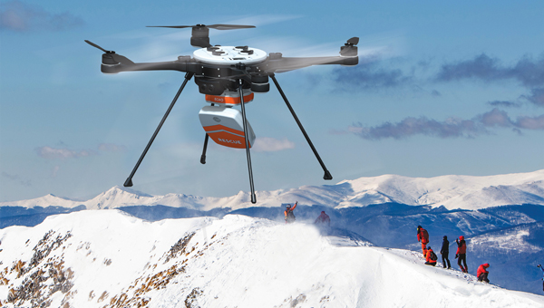
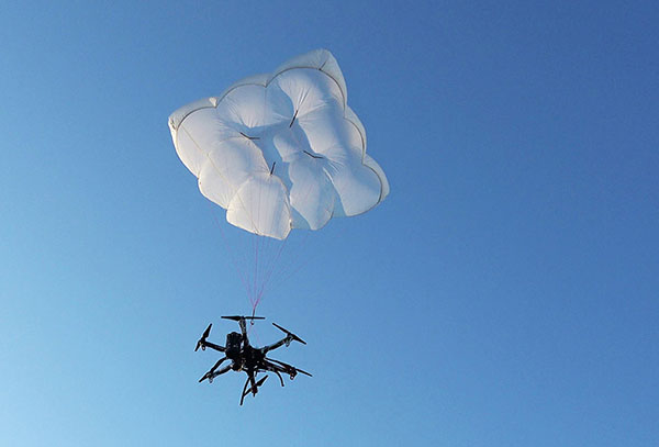
Smith Myers showcased ARTEMIS, a mobile phone detection and location system designed specifically for airborne search and rescue (SAR) and disaster relief, at a helicopter trade show in Dallas.
The company, founded 35 years ago in the United Kingdom, also designed and developed software-defined radio and cellular protocol stacks designed specifically for the SAR role. According to the company, ARTEMIS turns any mobile phone into a rescue beacon, only requiring two antennas to generate a latitude/longitude fix at up to 19 nautical miles (35 km), offering an alternative to traditional airborne sensors.
ARTEMIS’s features include:
texting and calls in no service areas
possible automatic cueing of electro-optical/infra-red (EO/IR)
deployment as a stand-alone with embedded mapping or integration with mission system providers
making missions in low light / instrument meteorological conditions (IMC) safer and more successful and
availability in several SWaP configurations for manned/unmanned platforms.
Smith Myers announced in February that ARTEMIS has been integrated into the new Robotics Centre Echo SAR payload for small unmanned aerial systems (UAS) built by Teledyne FLIR Defense.
ARTEMIS airborne capabilities are available for use on manned rotary and fixed-wing platforms and drones with large and small payloads. It has already been in service with the AW101 Norwegian all-weather SAR helicopter and can be deployed across payload categories down to a small quad-rotor UAV.
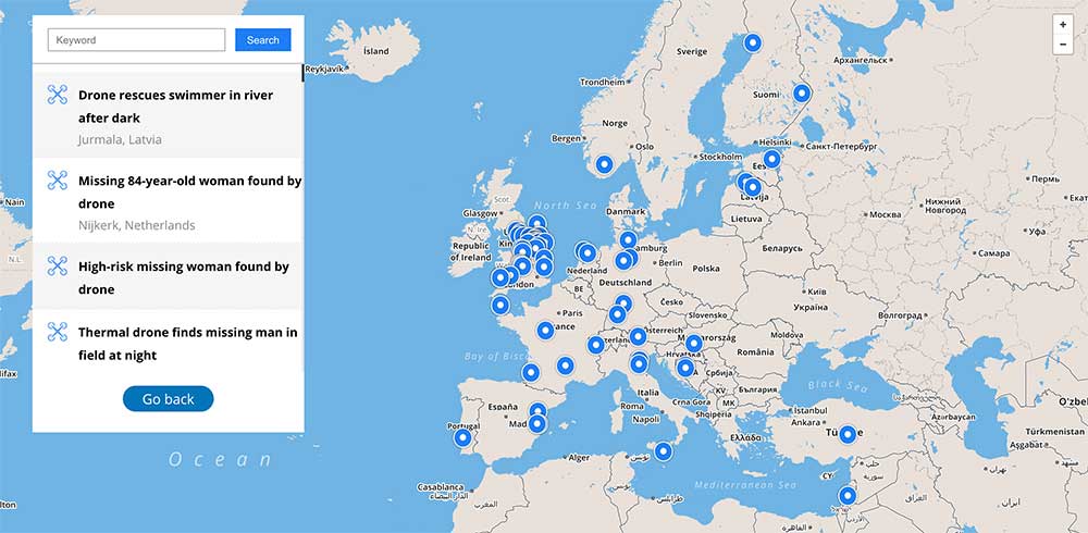
Global reference includes more than 400 people rescued by drones to date
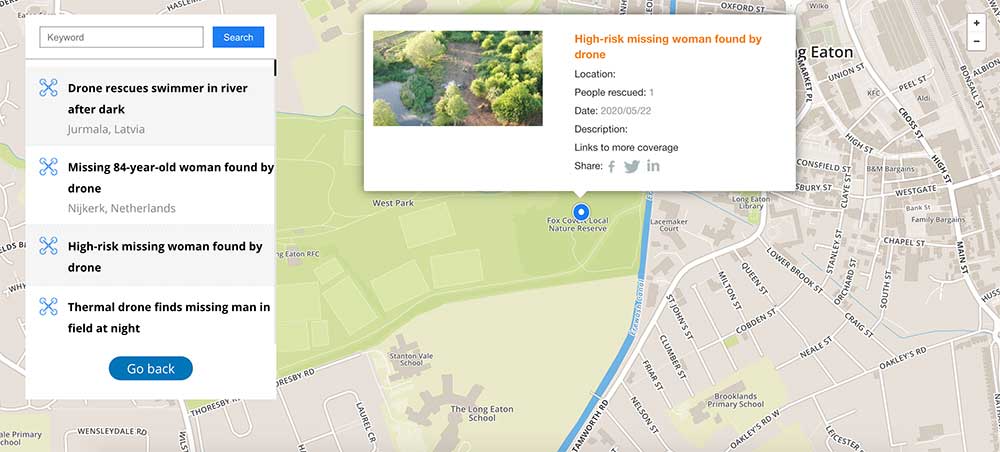
DJI has launched an online reference to track events around the world when a drone helped rescue someone from peril. The Drone Rescue Map shows how more than 400 people around the world have been helped by drones in more than 200 emergencies, and will be continually updated as new rescues occur.
The DJI Drone Rescue Map has been compiled from news stories and social media posts from authoritative sources such as police departments, fire departments and volunteer rescue squads.
Each entry on the map includes the location and date of the incident, a brief description, a link to the original story or post, and an easy way to share those incidents online. To make the map as definitive as possible, DJI encourages public safety agencies to share additional drone rescues so they can be included.
Once a week on average
The map includes rescues recorded in 27 countries across five continents, and shows how drone technology has moved from an experimental concept to standard public safety equipment.
The first drone rescue was recorded in Canada in 2013, the next one was more than a year later, and early examples of drone rescues were as likely to be performed by helpful bystanders as by professionals.
Today, drone rescues are reported about once a week on average, and public safety agencies routinely share those success stories on social media.
“The DJI Drone Rescue Map is now the best global reference for how effective drones are in emergencies, and allows the world to see the tremendous impact drones have had in finding lost people, shortening searches, reducing risks to rescuers and saving lives,” said Romeo Durscher, DJI senior director of public safety integration. “Public safety workers already know how drones are revolutionizing their work, and now the rest of the world can see their amazing stories in one place. The DJI Drone Rescue Map honors the incredible rescues they’ve made, and will allow everyone to see how drones help save people in the future.”
Types of rescues
The map includes instances of drones:
finding people lost in forests, fields and mountains, often in darkness using thermal imaging cameras
dropping life preservers to people struggling in water
locating boaters stranded on remote waterways
helping rescue people who were at risk of harming themselves.
The map does not include incidents when a drone is simply used as part of a larger search process; instead, a drone must have directly located, assisted or rescued a person in peril.
Many of these incidents illustrate how drones can find missing people more quickly than a traditional ground-based search, allowing victims to be brought to safety faster, more easily and with less risk and burden for their rescuers.
In some of the incidents on the DJI Drone Rescue Map, the drone helped accelerate a rescue and allow first responders to operate more efficiently.
In other incidents, the drone clearly made the difference between life and death.
Volunteer rescue
“I know how important drones are for people in distress, because a drone saved my life,” said Jason Mabee, a Maryland man who was injured and near death last year in a local park when he was found by a volunteer drone pilot. “My family and I are eternally grateful that a total stranger was able to use his drone to find me. It’s comforting to know that drones are helping so many other people around the world too, and I hope the DJI Drone Rescue Map demonstrates just why drones are so important in emergencies.”
“Drones have changed the game for finding and saving people lost in difficult conditions, and twice last year drones made the difference for us in finding and saving stranded hikers in dangerous terrain at night,” said Kyle Nordfors, Drone Team Coordinator for Weber County Search and Rescue in Utah. “Drones helped make these rescues possible while reducing risk and strain on our volunteer rescue force. We’re excited to see our successful efforts represented on the DJI Drone Rescue Map, and we hope it shows people all over the world how important drones are for saving lives and protecting the rescuers.”
DJI has previously released two detailed reports on how drones have been used to rescue people from peril around the world. The first, in 2017, counted 59 people rescued by drones, and the second saw the global total rise to 124 by 2018.
PC Tom Shainberg, senior drone pilot of the Alliance Drone Team for the Devon & Cornwall and Dorset police forces in England, said, “The Alliance Drone Team is proud to be a leader in adapting drone technology for police incidents, and we’re glad to see our successful drone rescues — such as finding a vulnerable man huddled near the edge of a cliff — being shared wider, along with similar accomplishments from other public safety agencies from around the world via the Drone Rescue Map.”
“Hundreds of examples now make clear that making drones widely accessible, with low barriers to entry and subject to a progressive set of operational regulations, leads inevitably to saving more lives around the world,” said Brendan Schulman, DJI Vice President of Policy & Legal Affairs. “The DJI Drone Rescue Map is a powerful resource for policymakers to understand the impact drones have on protecting vulnerable people in their own communities, and the detrimental consequences of policies that would restrict or discourage the use of drones, or increase the cost of using them. Regions with less favorable operating rules for drones appear to have substantially fewer reports of drone rescues.”
Seeking submissions
DJI monitors global news coverage, drone-related social media, and other sources to find new examples of drone rescues, but understands that many similar incidents may not yet be recorded on the map.
Anyone who knows of a drone-involved rescue not included on the DJI Drone Rescue Map can submit it through a form at the bottom of the map page.
These submissions will be reviewed for publication on the map, so DJI asks anyone submitting information about a rescue to respect the privacy rights and expectations of the persons involved, and to not share any confidential or sensitive information about agency operations.
Another month, another hurricane in the southern United States. News channels showed drone-captured video of the mess left behind in Northern Florida, Georgia and the Carolinas. More useful is the video damage assessments UAVs are providing for first responders.
A basketball hoop and backboard hang forlornly while both front and back walls of a school gym are gone, huge buildings are nothing but matchsticks, fallen trees and powerlines blocking roads — familiar scenes from hurricane Michael’s devastation of Panama City and area — video provided by drones operating in the disaster zone.
Although the videos have now largely gone from the TV news, Panhandle residents will be living through this nightmare for months to come.
Photo: Glenn Fawcett/Customs and Border Protection/Handout)
Working with emergency teams — including the North Carolina Surf City Fire Department, Airborne Response, Florida FEMA Task Force and Missouri Task Force FEMA — Edgybees’ AR drone software was able to provide collaborative, real-time, situational visualizations of the areas affected by Michael. Status and location updates were available during critical missions, and key geographical data was provided to teams on the ground.
Beach Patrol
Another life-saving drone application comes from the other side of the Pacific – finding and deterring sharks which threaten bathers off the beaches of Australia.
An artificial intelligence application on-board a SharkSpotter UAV monitors for shark attributes as it overflies inshore areas where the predators are known to hunt. If there is a match for typical shark behavior — size, shape, color, and movements in the water — an alert is transmitted to enable lifesavers to respond. The drone can even drop a flotation device to swimmers in trouble. A number of beaches in New South Wales were patroled this past summer, and many more UAV beach patrols are planned to be added for the coming season.
SharkSpotter drone. (Photo: Ripper Group)
Other work is underway to deter the animals using devices in the water which create electric fields aimed at interfering with shark sensory systems. Another cell-phone application estimates the probability of the presence of sharks based on a number of environmental factors. Several U.S. agencies are keenly watching these developments as shark attacks have increased here, off both Atlantic and Pacific beaches.
Meanwhile, there has been another important step forward for drone integration into the US National Airspace System (NAS) and for integration in other countries’ airspace. Enabling drones to fly over people and property is a key part of potential airspace operations, and a safe recovery system which avoids possible injury to people is becoming essential. Most drones have a return-to-base fallback in the event of loss of the control signal, but this doesn’t help in the event of a fundamental mechanical failure.
Parachute Recovery Systems
DJI Matrice 600 with DRS-10 rescue system. (Photo: Drone Rescue)
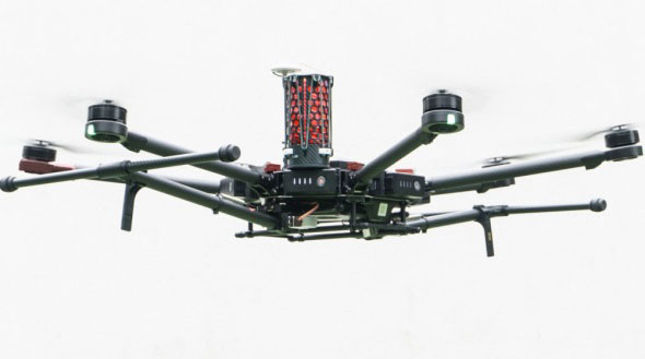
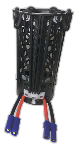
Effective auto-release parachute systems may be key to solving this problem. Another supplier has emerged with a lightweight automatic system for the DJI Matrice 600 multicopter.
Drone Rescue (DR) from Austria has announced its DR-10 parachute recovery system,for drones weighing 5-20 kg (11-44 lb). The DR-5 system is for lighter UAVs (8kg – 17.6lb).
The DRS-M600 system has apparently been derived from the DR-10 specifically for the DJI Matrice drone.
Photo: Drone Rescue
The parachute is mounted in a carbon cage and is released when a self-contained electronics system automatically detects an imminent crash. DR claims that their system works even in the event of control data link failure, and that incident data is collected in an on-board UAV flight-data recorder for subsequent analysis.
It was previously announced that an FAA waiver for flight over people was granted to North Dakota UAS operator, Botlink using a ParaZero Israel drone recovery parachute system.
Initial flights were conducted during a tailgating event prior to the North Dakota State University vs South Dakota State football game in North Dakota. The drone flew over crowds in the stadium’s parking lots and provided real-time video for local law enforcement and media companies.
This drone parachute safety system includes a fully autonomous triggering system that deploys quickly and reliably without being dependent on any manual operator’s response. During FAA testing it was necessary to demonstrate that the descent rate was slow enough to provide acceptably low impact energy and that the system would operate correctly in multiple types of failure conditions.
DHL Drone Delivery
Meanwhile, DHL has joined other drone delivery companies to establish a medical delivery trial in Africa. DHL’s trial is in the Lake Victoria region of Tanzania.
The six-month trial has focused on delivered medicines by UAV within 40 minutes to an island in Lake Victoria — the trip normally takes six hours by road.
Photo: DHL
Over the course of 160 proving flights, using a 4-kg-capacity Wingcopter, medical supplies were successfully transported over the 60 kilometers between Mwanza and the hospital on the island of Ukerewe.
The medicines reach their destination at least 3 hours earlier than by any traditional mode of transportation, and as a result of these tests, 400,000 people in the Ukerewe District will now have access to medical care and support in hours rather than days.
Conclusion
Drones helping out hurricane Michael recovery efforts in the Florida Panhandle, specialized drones tracking sharks to mitigate possible attacks off beaches in Australia, parachute recovery systems enabling drone flights over people, the integration of drones into regular airspace moving ahead, and more medical delivery trials in Africa. These are a few recent UAV applications that appear to be supporting even further drone use around the world.
Drone Rescue will present its parachute systems DRS-5 and DRS-10 to the professional public for the first time at Intergeo, at stand 12.0B.112 in Hall 12, Oct. 16-18.
Parachute rescue system DRS-5 is designed for multicopters with a total weight of up to 8 kg. The system consists of a carbon cage in which the parachute is stored, as well as the associated electronics.
The electronics, including the sensors, monitor the flight status of a drone independent of the flight controller. A sophisticated algorithm merges this sensor data, through which an automatic crash detection can be realized, the company said. In an emergency, the pilot no longer needs to react and press an eject button. (Often, this is technically no longer possible anyway, such as with a failure of the radio link.)
Furthermore, the algorithm reacts faster than the pilot: the system ejects the parachute itself. All flight data and movements are recorded in a black box. In an emergency, these can be read out at the request of the customer and made available to insurance companies or authorities.
“Our goal is to ensure that even in an emergency beyond visual line of sight the drone can be safely intercepted. With our parachute system, that is always possible, due to the electronics that are completely separate and independent of the flight controller,” said Andreas Ploier, CEO and co-founder of Drone Rescue. “In addition, our system has the advantage that it manages completely without explosive, pyrotechnical solutions. Consequently we have a system that is considerably lighter, and functions even in a worst-case scenario.”
DRS10 system. (Photo: Drone Rescue)
The reliability of the system has been verified in extensive tests by Joanneum Aeronautics in Graz, Austria. In the framework of the tests, 100 flights were conducted during which the parachute system was ejected.
Half of the flights were conducted with a DJI F550 weighing 1.6 kg. The rest of the tests were performed with the 3.8 kg Vulture, which was developed by the FH Joanneum.
In both cases, the DRS-5 was attached to the side of the main body of the drone. In each of the tests the parachute was ejected at a height of 30 meters. Every test was documented.
Furthermore, the data were saved both in the flight controller as well as in the DRS-5 sensor system. After every 10th test, the parachute system was subjected to a visual examination and checked for possible damage or wear.
“After conclusion of the tests, it can be recorded that all 100 flights were successfully completed,” Ploier said. “In every test the multicopter landed safely. Thereby, the kinetic energy was significantly below the limit of 79 J. All requirements specified by the European Aviation Safety Agency (EASA) were observed.”
Besides the DRS-5, the structurally identical parachute system DRS-10, which is designed for multicopters with a total weight between 5 and 20 kg, will also be presented at Intergeo 2018. “The DRS-10 system functions exactly the same as the DRS-5 and falls back on the same components. These are constructed identically, just oriented for a higher payload. The functioning method of both parachute systems is identical,” Ploier said.
With flight tests for the DRS-5 completed in late summer, the first systems will be delivered to end customers in winter 2018.
At least 65 people have been rescued by drones in the last year, according to a new report issued by DJI, a civilian drones and aerial imaging company.
The report gathers accounts from news outlets and public safety agencies around the world, and includes 27 separate incidents on five continents.
The report, “More Lives Saved: A Year Of Drone Rescues Around The World,” is available for download. It highlights how improved drone technology, rapid adoption by first responders, and smart aviation regulations have combined to increase the pace of drone use in critical public safety missions.
dropped buoys to struggling swimmers in Australia and Brazil,
spotted unconscious victims in sub-freezing weather in England and America, and
found stranded people in fields, rivers and mountains.
“Drones allow rescuers a way to find missing people, deliver supplies like food and life vests, and cut search and response times from hours to minutes,” said Brendan Schulman, DJI vice president for policy and legal affairs. “When laws and regulations allow public safety agencies to deploy drones easily, rescuers are able to save time and money, protect their personnel, and most importantly, rescue people from peril.”
More than one person a week was rescued by a drone over the last year on average, the report found, including at least 18 found by thermal imaging cameras that can sense a person’s body heat even in darkness or when hidden by thick brush.
In one case, police in Lincolnshire, England responded to a car crash on a dark rural road on a cold night but were unable to find the driver. A drone with a thermal imaging camera spotted the driver in a ditch away from the crash scene, and captured the dramatic moments when it guided officers to find him. See video below.