Drone Safety Day (DSD) is returning for its fifth consecutive year on April 29. The annual campaign, designed by the Federal Aviation Administration (FAA), is dedicated to educating the drone community on the importance of flying safely.
The event will highlight the societal, economic, and safety benefits of safe drone operations. DSD will feature in-person, virtual and hybrid events in areas such as education, economics, equity, environment and emergencies.
DSD provides opportunities for businesses, schools and organizations to share how they use drones, as well as kick off new safety initiatives. The 2023 campaign encourages drone pilots and recreational flyers to “Fly RIGHT” by focusing on five safety elements:
Register your drone
Interact with others
Gain knowledge
Have a safety plan
TRUST and Train
A full list of events and registration can be found on the FAA website.
DJI Mavic 3 has better sensor, dual-camera system, omnidirectional obstacle sensing, smarter flight modes and longer flight times
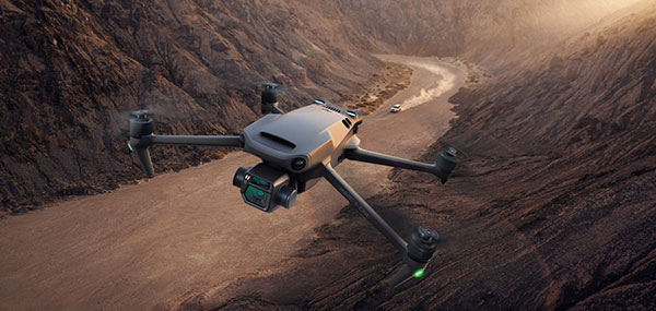
Mavic 3 drone. (Image: DJI)
The new DJI Mavic 3 is an update of the company’s folding camera drone, providing comprehensive improvement and boosting performance for aerial photography.
The Mavic 3 has improved navigation and obstacle sensing systems. A powerful positioning algorithm improves hovering precision with signals from GPS, GLONASS and BeiDou satellites. This enables Mavic 3 to lock onto multiple satellite signals faster. The increased positioning precision also makes the drone less likely to drift in the air and more stable when shooting long exposures and time lapses.
For its obstacle sensing system, Advanced Pilot Assistance System (APAS) 5.0 combines inputs from six fish-eye vision sensors and two wide-angle sensors, which seamlessly and continuously sense obstacles in all directions and plan safe flight routes to avoid them, even in complicated environments.
The obstacle-sensing system also enables more intuitive subject tracking with the upgraded ActiveTrack 5.0. Previous iterations of ActiveTrack enabled the camera to follow a subject as it moved directly toward and away from the drone while remaining largely stationary as well as fly alongside a moving subject. ActiveTrack 5.0 allows Mavic 3 to move with the subject as it moves forward, backward, left, right and diagonally, and fly alongside as well as around a moving subject.
If the subject moves too fast and temporarily goes out of frame, visual sensors on the aircraft will continue to track and frame the subject intelligently and pick it back up when it reappears. These new directions enable much more fluid and diverse drone and camera movement while using ActiveTrack.
Other safety features include geofencing, which alerts drone pilots when they fly near sensitive locations; altitude limits to ensure pilots are aware of altitude restrictions; and the AeroScope Remote ID system that allows authorities to identify and monitor airborne drones in sensitive locations.
Mavic 3’s integrated AirSense system, first widely introduced in DJI Air 2S, warns drone pilots of nearby airplanes and helicopters transmitting ADS-B signals, so they can quickly fly to a safer location.
Hasselblad camera
Mavic 3 has a 4/3 CMOS Hasselblad camera and 28x hybrid zoom camera. Omnidirectional obstacle sensors have a 200-meter range, and redesigned batteries provide up to 46 minutes of flight time.
Upgraded hardware and software can process 5.1K video at 50 frames per second and support 4K/120 fps for high-quality results for slow-motion footage. An enhanced Mavic 3 Cine edition offers Apple ProRes 422 HQ encoding for richer video processing, with an internal 1TB SSD onboard for high-speed data storage.
DJI Mavic 3’s customized L2D-20c aerial camera embeds a professional-grade 4/3 CMOS sensor with a 24 mm prime lens in a sleek and compact form. Rigorous Hasselblad standards for hardware performance and software algorithms allow it to shoot 20-MP still images in 12-bit RAW format and videos in 5.1 K at 50 fps and 4 K at 120 fps. The higher video definition creates smoother footage and more generous cropping possibilities and allows for slow-motion video at 120 fps.
The larger image sensor gives Mavic 3 higher video resolution and dynamic range and more effectively suppresses noise in low-light environments. A native dynamic range of 12.8 stops helps retain more details in highlights and shadows, preserving rich visual information with a greater sense of depth and elevating imagery to a professional level. An adjustable aperture of f/2.8-f/11 is available to meet the needs of aerial photographers in a wide variety of lighting scenarios to get sharper and clearer images.
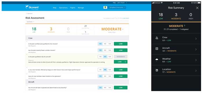
Skyward has released a new risk assessment tool for its Aviation Management Platform, which is designed to help drone program managers proactively identify and document critical risks to an operation.
For assessing risk, users answer a series of risk questions developed by Skyward’s drone experts and based on aviation best practices. Each answer is assigned a risk level: low, moderate or high. As each question is answered, an overall risk summary score is generated based on the highest level of risk present, Skyward said.
Photo: Skyward
Users can also add mitigation for any risk level by adding explanations and adjusting the risk levels. The mitigated risk will be noted in the summary, and the note will be synced across the Skyward software platform.
Skyward, based in Portland, Oregon, develops drone programs for industries such as construction, industrial inspection, media, insurance, real estate, mining, precision agriculture and more. Skyward was acquired by Verizon in 2017.
When it comes to producing film imagery, it’s all about perspective.
Picture this: You’re in a courtyard surrounded by four high-rise buildings, looking up. You’re tasked with flying a drone equipped with a movie camera between two of the buildings, and then up one of them.
It’s a challenge, but perspective is critical when it comes to filming technology-focused movies like Pacific Rim: Uprising.
High-resolution imagery has become a critical component for Hollywood film producers over the years, and drones have played a paramount role in offering unique viewpoints.
More importantly, drones allow users to capture imagery that humans alone can’t produce.
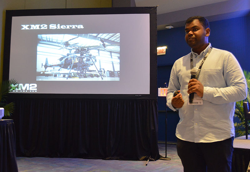
XM2’s Aaron Corera discusses the company’s drone imagery at Xponential 2019. (Photo: Allison Barwacz)
XM2, an aerial cinematography and photography company based in Melbourne, Australia, uses drones to capture this compelling imagery. The company has worked on a number of big-name projects, including Pacific Rim: Uprising, Thor: Ragnarok, Aquaman, season two of Westworld, Pirates of the Caribbean: Dead Men Tell No Tales and Star Wars: Episode IX.
“Star Wars: Episode IX was certainly a big challenge,” said Aaron Corera, drone pilot and safety manager at XM2, at an education session at Xponential 2019. “It was a massive challenge logistically to get all of our equipment over there, and then in an environment where there’s very little infrastructure, essentially, to be able to do some high-pressure tasks. It’s just a matter of being well prepared, being switched on and working through a checklist to make sure every box is being ticked.”
The company has manufactured a number of its own drones to meet the needs of its clients. One of its drones — the XM2 Sierra — is capable of carrying payloads up to 66 pounds.
“It is designed to be able to carry cameras that traditionally aren’t drone-based cameras,” Corera said. “That aircraft can carry the same cameras that are being used for the ground-based shooting, and that’s a big advantage. Having all platforms using the cameras saves them time in post-production.”
The company’s other house-manufactured drones include the Tango, Echo and Inspire Pro 2, which have been deployed over a number of the company’s projects.
The work didn’t come immediately, though. The 14-person staff at XM2 has only been working in the film industry for about seven years, Corera said.
“The work came in bits and pieces, and we gained momentum into it a little bit, then realized, ‘There’s a real opportunity here,’” he added.
One of the biggest challenges the company has had to face is unfamiliarity with the products and what XM2 can offer.
“I think one of the challenges includes familiarity, ultimately,” Corera said. “And that’s familiarity in the systems for the client and what it can and can’t do.”
Because a lot of people aren’t familiar with drones and the legal requirements to fly them, XM2 has had to find alternatives for client requests, as well as educate and ensure the safety of the people working around them.
“From the people management side of things, when we’re operating on a film set, it’s about coordination between the people that are involved in the shot itself and then the people that are managing the film set,” Corera said. “And then there will generally be on-set safety, as well. We’ll have a briefing in the morning, and explain what we’ve got planned for the day.
“When it comes to a specific shot, we take it upon ourselves to know exactly where everyone is, exactly what they’re doing and where they’re going. We make sure everyone knows what the plan is and what to do in case something goes wrong. It’s a combination of technical safety protocols and people safety protocols.”
Still, as technology evolves, the demand for high-resolution, drone imagery does, too. It’s all about perspective and, more importantly, capturing imagery from a viewpoint otherwise unseen.
New app will improve the safety and reliability of drone flights across the United States.
The Federal Aviation Administration (FAA) has partnered with Kittyhawk to redevelop B4UFLY to further its safety mission and create a new and improved mobile application to help recreational drone operators learn where they can and can’t fly.
The project is being done at no cost to the FAA.
Photo: FAA
The B4UFLY app will continue to be available to the public until the new app is deployed. The data will continue to be updated, but no new features will be added.
“We want to provide drone pilots with the best tools possible so they fly safely and responsibly,” said Acting FAA Administrator Dan Elwell. “As drone sales increase and our nation’s airspace becomes busier and more complex, it’s vital that we work smarter and partner with the private sector to develop innovative products that advance safety.”
The FAA and Kittyhawk’s Feb. 13 agreement will provide the public with a simple, easy-to-understand mobile application that provides situational awareness for recreational drone pilots. The FAA and Kittyhawk plan to launch the new app later this year.
Kittyhawk is an enterprise drone operations software company and has been an FAA Low Altitude Authorization and Notification Capability (LAANC) UAS service supplier since October 2018.
Drone operational rules have quite a few restrictions, largely aimed at keeping unmanned aircraft away from manned and commercial aircraft operations. The Federal Aviation Administration (FAA) has set a boundary limit for UAV operations to stay a minimum of 5 miles away from any airport. So it’s a little surprising that at least one airport is actually carrying on trials to fly drones within airport property.
The reason is birds. Most airports are large, open spaces where birds love to land in large numbers to seek food and to rest, so airports and aircraft have to cope with the problem of avoiding bird-strikes in the critical phases of take-off and landing.
Airports have used remotely compressed air cannons, and manually fired ordinance that “screams” or explodes making various forms of loud noise, or dogs or even hunting falcons of different species. Birds, however, become habituated to cannons and guns, and neither dogs nor hunting falcons can be relied on to actually herd birds away from runways.
All this is in an effort to drive flocks of birds away from runways and low-altitude aircraft traffic corridors. At high altitude, a bird strike is usually survivable and an aircraft still has sufficient energy to be able to glide in the event of a complete engine-out situation, giving the pilot time to find a landing place. U.S. Air’s Chesley Sullenberger was a great airman to save his passengers and aircraft, but he was also lucky to have the Hudson right there to ditch into. He was some cool dude when he put his Airbus A320 down on the river, once losing both engines at low altitude on take-off after flying through a flock of Canada Geese.
Enter Robird, a drone that looks — and behaves, in the right operator’s hands — like a female peregrine falcon, with flapping wing propulsion and attack moves emulating the predatory bird. Flown by a pilot and accompanied by an observer whose primary job is to ensure the UAV “bird” stays away from runways, the pair seeks resting flocks of birds that pose risk to aircraft within the boundaries of an operational airport.
https://youtu.be/-gc8kBmzOOI
Clear Flight Solutions in Holland has recently undertaken a trial at Edmonton airport in Alberta, Canada, where it obtained special flight clearance to fly within the airport grounds to demonstrate how its mechanical falcon could clear birds away from airport danger zones.
Of course, drones and aircraft don’t mix either, so flight rules within the drone systems (GPS/autopilot?) apparently include geofenced no-go areas corresponding with runways and approach areas, and there is a shutdown mode in case of loss of signal or other failure — avoiding runway incursion is all important.
Registration is back on
Since U.S. Federal Aviation Administration (FAA) regulations requiring registration of small UAVs (sUAV) and model aircraft were struck down last spring by the appeals court, the need to register has been in abeyance. However, Congress has rolled a new requirement back into the recently signed $700 billion National Defense Authorization Act, making registration of any sUAS or recreational model aircraft a legal requirement, subject to fines for lack of compliance.
The FAA has continued to advocate registration as a means to track wayward operators and to enforce separation of drones from manned aircraft. AUVSI has also continued to support the FAA position. A 2012 law, on the other hand, was said to prevent the FAA from making rules covering “model aircraft,” defined as “unmanned aircraft” flown for recreational purposes.
The new regulation within the Defense Authorization Act has now apparently clarified and overcome any contradictions — recreational model aircraft and drones all have to be registered.
DJI claims and counter-claims
The U.S. Immigration and Customs Enforcement’s (ICE’s) recent claims that manufacturer DJI could be spying for the Chinese Government have been refuted by DJI.
DJI has responded that allegations are wrong and that ICE should consider withdrawing or correcting unsupportable assertions. But claims persist that the Chinese government may be using information gathered by DJI UAVs to target potential assets for purchase.
A large wine producer in California used DJI UAS to survey its vineyards and monitor grape production, but soon afterwards a number of Chinese companies apparently purchased vineyards in the same area. So it’s being alleged that the companies appear to somehow have used DJI data.
DJI UAVs collects reflective images of leaves to calculate the nitrogen levels of plants using a specialized infrared scanner. The scanner enables growers to deduce how much nitrogen to add to the soil to optimize plant growth. Information on the location and stages of crop growth can also be collected. As of May, it’s been reported that DJI’s only customers using this particular scanner were wine producers along California’s Pacific Coast.
Most UAVs would seem to be capable of collecting location and geographic information data; however, these claims are being leveled at manufacturer DJI. In a website statement, DJI denied any wrongdoing but hinted that some of its data storage may have been compromised.
This story may be far from over.
Potential new aircraft control systems?
I recall climbing around in the fuselage of a Jet Provost training jet back in my apprenticeship years at BAE in the UK — I was wiring in auxiliary systems. But the thing I remember most was the mass of control cables running down the top center of the aircraft and winding their way to control surfaces via pulleys, with in-line tensioners and rubber lined holes to pass through bulkheads. I thought, How reliable could this be? Of course, it’s the way almost every aircraft control system has been constructed since Wilber, Orville and wing-warping. Up until we got fly-by wire and electrical actuators, that is — then mechanical cables became less prevalent, except for reversionary back-up.
But making surfaces pop up into the airstream around an aircraft is how we’ve been able to take off, maneuver and land aircraft/UAVs — up to now. Elevators, rudders, ailerons, leading and trialling edge flaps, speed brakes — all of them control pitch (up and down), yaw (left to right), roll and manage lift. These mechanical control surfaces sprout out of the wings and horizontal and vertical stabilizers, and provide control for the pilot, autopilot or onboard flight computer.
Now BAE Systems and Manchester University (MAN U) in the UK have come up with a different way to control a flying vehicle without using moving control surfaces. If the smooth surfaces of a stealth aircraft were to be never disturbed, the stealth radar signature of the vehicle would remain unchanged even during maneuvering — a handy enhancement to have to keep an aircraft as invisible as when it’s “clean” in level flight.
The BAE/MAN U innovation, incorporated into a new MAGMA drone, uses internal, redirected air from the engine to “blow” the aircraft into a different direction. The small demonstration UAV has apparently completed a successful first flight.
These innovations could both reduce mechanical complexity and improve the integrity of a stealth signature, by removing conventional control surfaces. Wing circulation control redirects supersonic air from the engine and blows it through the trailing edge of the wing. Thrust vectoring changes the direction of the aircraft’s exhaust.
When used together, these control the direction of the aircraft by manipulating the air around it. Hydraulic and electrical actuators have been replaced by air redirecting ducts and air blowers, which may simplify build and flight controls without making the air vehicle more visible to radar. Of course, taking additional airflow from the engine means the engine has to be more powerful to provide the additional airflow, so this doesn’t come for free.
The technologies being developed may enable cheaper, higher performance, next-generation aircraft. Its hoped that R&D will contribute towards technological improvements for advanced military aircraft. These trials are an important step forward in the exploration of adaptable airframes — along with other work to improve the performance of UAVs in collaboration with the University of Arizona and NATO Science and Technology Organization.
MicroPilot adds sense and avoid
MicroPilot in Manitoba, Canada, is a leading supplier of autoflight solutions for the UAS industry. The latest MicroPilot autopilots include integrated control datalinks, and they are small, lightweight and interface with a wide range of sensors. MicroPilot has now integrated its UAV autopilot with the FLARM sense and avoid system, adding an essential element for autonomous and beyond-visual-line-of-sight (BVLOS) operations.
FLARM is a traffic awareness and collision avoidance technology used by light aircraft and UAVs. When integrated with MicroPilot’s autopilot, the system alerts the autopilot of any close-by, suitably equipped aircraft. FLARM outputs the velocity and altitude of these detected targets, and the autopilot then decides how to avoid them.
FLARM collision avoidance systems, used by manned aircraft for more than a decade, now come with an ADS-B out option that broadcasts the UAV’s position to alert other aircraft to its location. Together, the MicroPilot autopilot and integrated FLARM system offer a unique combination of automated flight control and sense-and-avoid capability for UAS developers.
Summary
So bird-hunting, wing-flapping, bird-like UAVs being used to clear airports to prevent collisions between birds and aircraft; you will need to put down your $5 registration fee with the FAA if you want to fly your own UAV because new legislation has replaced that previously struck down in the courts; DJI and the U.S. ICE seem to be on some sort of a collision course; BAE and MAN U appear to be on the verge of a potentially revolutionary system with which to affect flight control of aircraft and a combined system for autoflight and collision avoidance — just a few of the many things happening this month in the UAV industry.
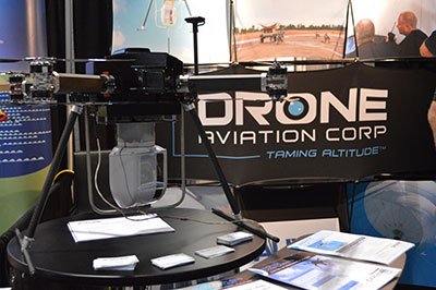
CNN will use Drone Aviation’s tethered drones to gather footage in in urban areas from never-seen-before angles and heights. The company’s WATT-200 was unveiled at the AUVSI this week.
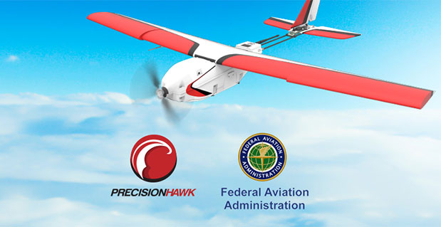
Federal Aviation Administration (FAA) Administrator Michael Huerta announced two new initiatives related to unmanned aircraft systems (UAS) today at the Association for Unmanned Vehicle Systems International (AUVSI) Unmanned Systems 2015 conference in Atlanta, Ga.
Administrator Huerta told the large gathering of national journalists, “The unmanned aircraft industry is changing faster than any segment in the aircraft industry. A new project to harness that energy, the Pathfinder program, is partnering with three leading U.S. companies to expand unmanned aircraft operations in the United States.”
The FAA is working with industry partners on three focus areas:
CNN (Cable News Network) will research visual line of sight (LOS) operations for newsgathering in urban areas. CNN will continue working with Georgia Tech University to improve newsgathering for all organizations.
PrecisionHawk will investigate agricultural operations for rural areas, flying outside LOS.
BNSF Railway, second-largest freight railroad network in North America, will undertake inspection of rail infrastructure, also beyond visual LOS.
Huerta said that the partners, collectively, “are trying to push the envelope, what can we accommodate, accommodate safely, and what can we learn from that. We’ll test a little, learn a little, then test some more. How do we see a staged implementation? To integrate unmanned aircraft, but to do it safely, as directed by Congress. We’re trying to push the edges of what we can allow, working with partners who have specific uses and resources that they will apply to those.”
When asked for a timeframe to reach new UAV regulations, he replied, “I can’t comment a lot on the rule itself, but it’s fair to say that in the rulemaking comment process [which closed on April 24], we received more than 4,500 comments. It’s too early to say how those comments will shape what the final rulemaking will take. Assessment will be done in the coming months, perhaps by the end of the year, but that’s an aggressive timetable. This effort will go on as long as the partners want us to go on doing it. That’s not accomplished in six months, nor should it take a million years.”
As to LOS restrictions, and beyond LOS, he replied, “The framework of the previously published rule was focused on LOS, and on the use of visual observers in addition to the operator. Now we’re taking the next step, to explore beyond LOS uses. What are reasonable applications for that, and what mitigations for safety should be put in place for that? Everyone wants to get there. It’s important to figure out how we get there safely.”
What mitigations will be put in place for beyond LOS? A vice president of BSNF Railway said that the company is “working with FAA and several vendors around command and control infrastructure. This is yet to be fully defined. The railroad is a very safe an unforgiving environment. This doesn’t replace anything we’re doing today, it’s an addition.” He defined the operating environment as ” a 300 or 400-mile capability, to fly looking for broken rail, etc., beyond the visual, on-the-ground inspections that rail crews already do. ” He anticiated the use of “sense-and-avoid technology [for the UAVs], not using chase planes but perhaps using communications capabilities from cell towers and railway infrastructure along the right of way.”
The CEO of PrecisionHawk commented similarly, “We’re not changing much of our operational flow, just extending the baseline for it. We will implement a traffic-management technology, called Lattice, leveraging to ensure safety and reliability beyond the operator’s LOS.”
Gregory Agvent, CNN’s director of News Operations, said he looked forward to “some camera shots that were previously impossible for us, that now we’re going to be able to do.” Under the terms of the Certificate of Authorization (COA), Agvent said that “We’re capable of doing it [undertaking UAV missions] without asking for (FAA) permission” for specific flights.
The three industry participants concurred that they will work with their [UAV] partners in parallel with the rules to develop a certification process, so that the FAA can determine their vehicles are uniformly safe, the same way the y do with piloted aircraft currently. Both the railroad and PrecisionHawk have one currently operating flight platform each, and are looking at others, as theirs do not fit all applications.
“These are not exclusive [agreements],” emphasized Huerta, “limited to particular platforms or applications. This is a practical research effort to apply, learn, and integrate on the broadest scale.” When asked about possible further participants in the Pathfinder project, Huerta indicated the three companies represented on the briefing platform with him: “They came to us. You can interpret that as an invitation. We’re casting a very wide net. How do we et to a broader integration and implementation? We need multiple ways to gather information.”
Agvent urged, “It’s critical for manufacturers to come to the table, to get certified by make as opposed to individual models, to get free access to the sky.”
Huerta concluded, “We are learning together, as an industry and as a regulator. How can we collectively, as an industry, learn more in order to see a much more robust integration of unmanned aircraft into our aviation industry? We’re all interested in pushing the boundaries, and sharing the information broadly across the industry.”
The surprise preview of the pending announcement drew scores of curious and concerned industry representatives and exhibitors at the massive AUVSI show, who gathered anxiously outside the press briefing room, to which they were not admitted.
“The FAA is moving ahead with safe integration of UAS into the busiest, most complex airspace in the world,” according to an FAA statement issued prior to the briefing.”Even as the agency proceeds with rulemaking for small UAS, it continues to look at new ways to foster safe UAS operations by both hobbyists and businesses.”