Tag: DroneSAR

  • Humanitarians using life-saving drones honored at AUVSI Xponential

    Humanitarians using life-saving drones honored at AUVSI Xponential

    Five organizations that flew drones on critical, life-saving missions are winners of the inaugural XCELLENCE Humanitarian Award by the Association for Unmanned Vehicles Systems International (AUVSI).

    The award, which is sponsored by DJI, was presented at the AUVSI Xponential 2018 conference at the Colorado Convention Center in Denver.

    “We are thrilled to recognize and reward organizations who have utilized drone technology to make great contributions to their communities and the environment, through AUVSI’s inaugural Humanitarian Awards,” said Michael Perry, managing director of North America at DJI.

    “We congratulate the winners and thank all those who have participated for sharing the innovative ways they use drones to support humanitarian and life-saving efforts around the world,” Perry said. “We hope this award will inspire more organizations and drone operators to accomplish great feats and help others in their community.”

    In Rwanda, fresh blood is launched to a hospital using a Zipline drone. (Image: CNN video)

    These first recipients of the AUVSI XCELLENCE Humanitarian Award were recognized for using drones for disaster management, medical assistance and search-and-rescue operations at locations around the world:

    • Aeryon Labs Inc.: Aeryon SkyRanger UAS provides critical aerial intelligence to first responders in Sint Maarten in the wake of Hurricane Irma (Canada).
    • DroneSAR, DroneSAR UAV Search & Rescue (SAR) Solution: Executing autonomous aerial search and delivering live drone data to augment first response efforts (Ireland).
    • Nepal Flying Labs: drone hazard and vulnerability mapping in Nepal (Nepal).
    • ONG DroneSAR Chile: Emergency response team and humanitarian aid through the use of drones (Chile).
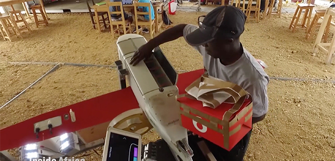
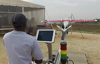
    • Zipline International: Zipline’s medical drone delivery operation in Rwanda (Rwanda).

    “As these organizations have shown, unmanned aircraft systems that are typically flown for commercial purposes are also capable of accomplishing vital humanitarian missions,” said Brian Wynne, president and CEO of AUVSI. “With sophisticated on-board cameras and sensors, drones can quickly fly to remote locations or areas that are inaccessible to ground vehicles because of roads blocked by storm debris or flooding.”

    The five organizations will equally divide a $25,000 donation as prizes for their ground-breaking humanitarian and philanthropic efforts.

  • DJI and DroneSAR launch rescue app for first responders

    DJI and DroneSAR launch rescue app for first responders

    DJI, maker of unmanned aerial vehicles, and DroneSAR, an Irish tech start-up for search and rescue, on Thursday announced a new search and rescue app that seamlessly integrates a drone’s unique aerial perspective on life-and-death searches into incident management software, ensuring rescue crews can use drones effectively to save lives.

    DroneSAR can stream live images and video, from a regular or thermal imaging camera, to an incident command center as well as other rescue teams on the ground. The software can tag the GPS coordinates of a victim and automatically transmit them by email or SMS, enabling ground crews to reach victims more quickly. Completed search patterns are all recorded and logged for easy handover to oncoming rescue crews.

    Screengrab: DroneSARThe app takes into account various types of terrain, allowing the drone to fly patterns to survey an area faster and more effectively. Flight paths can be adjusted for any terrain including hills, mountains, trees or flat land. The software allows users to choose an automatic aerial search pattern based on variables such as altitude, field of view, battery life and probability of detection. By organizing the process of data collection and providing a framework to manage and analyze it, DroneSAR ensures drones can be used methodically as part of a rescue protocol, allowing personnel to work more safely and effectively.

    “From understanding on how to use the technology, to communicating findings and data, to figuring out the most appropriate tactical approach, first responders can benefit greatly from this software app on our DJI hardware,” said Romeo Durscher, director of Education at DJI. “Many of the tasks and strategies deployed during a search and rescue operation can get sped up with automation, helping to reduce the time it takes to find a victim and save lives.”

    The software was developed based on research done by DJI in conjunction with the European Emergency Number Association and Ireland’s Donegal Mountain Search and Rescue team. The groups found that while a five-person rescue team on foot needs an average of two hours to find a victim in one square kilometer, a drone can do the job in 20 minutes or less while taking additional active steps to achieve a successful rescue.

    “Our aim is to save lives,” said Oisin McGrath, co-founder and CEO of DroneSAR. “Our software will reduce risk to search teams and reduce search time. If we can save just one life, that is mission success for us at DroneSAR.”