Tag: DT Research

  • Product review: Rugged tablet tackles survey tasks

    Product review: Rugged tablet tackles survey tasks

    Photo: DT Research
    Photo: DT Research

    Technology continues to develop and put more capability, data storage and ease of use into many professional’s hands, and surveyors are no different in their needs.

    Spatial data collection has become an important task in the diverse service world of today’s surveyor with a variety of platforms, sensors and techniques being used to provide this operation.

    The movement toward completing a “digital twin” of existing improvements and facilities worldwide has opened the door for new means and methods for data collection. Surveyors are taking a front-line role in producing the spatial data necessary for much of the internal and external infrastructure being used in today’s cutting-edge digital modeling.

    Necessary accuracy and precision

    However, not all data-collection systems offer the accuracy and precision deemed necessary by today’s surveying profession. These systems also need to be tough enough to handle the environmental conditions surveyors face in their everyday work, yet be user-friendly enough to make the data-collection process efficient.

    Surveyors require a system designed for rugged use, yet built with a high-visibility screen, easy-to-use interface and reasonable battery life to allow effective and confident data collection. Many data collectors tout these features, but many of them fail when subjected to the harsh conditions of surveying and construction sites.

    Times, however, are a changing and a new tablet is raising eyebrows.

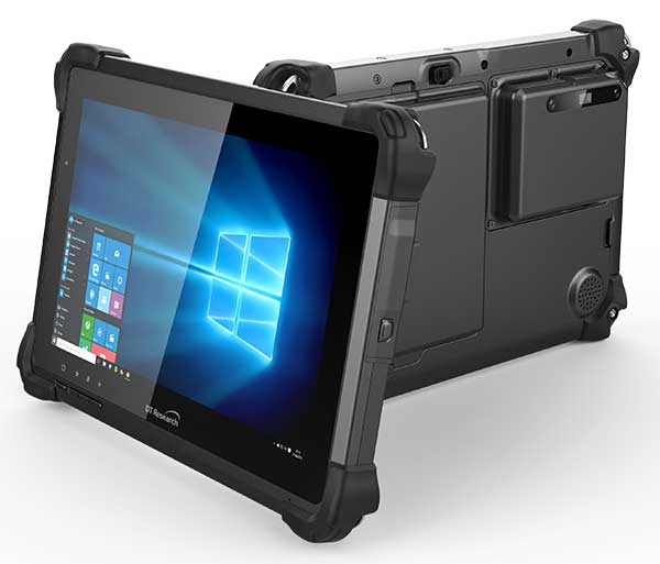
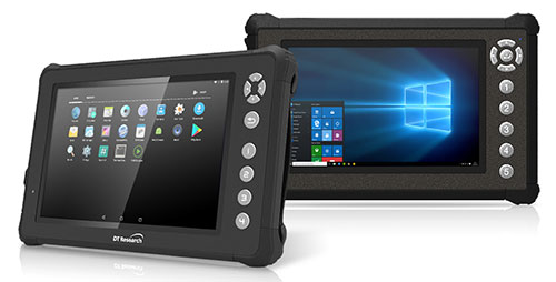
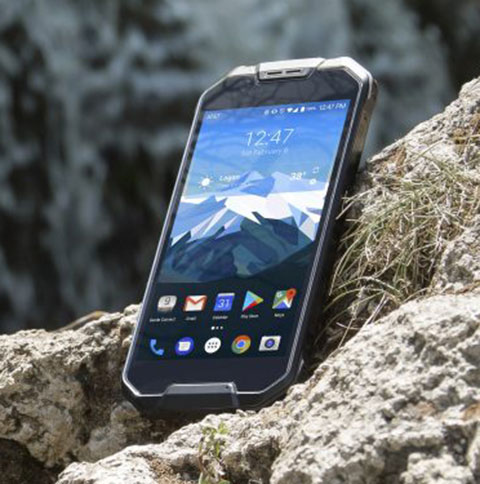
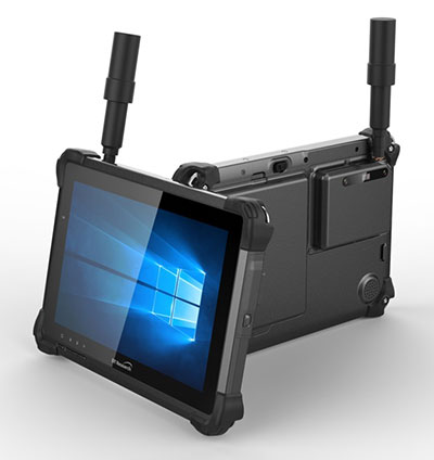
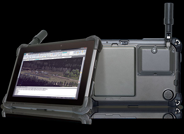
    DT Research Inc., a Silicon Valley electronics provider, has provided mobile and medical computing devices to many professions for more than 20 years. They have taken one of their most popular models, the DT301, and added integrated significant upgrades that brings it squarely into the surveying and geospatial world.

    This rugged tablet can now include a multi-frequency GNSS module and a second, 3D-capable, stereo-imaging camera for capturing photometric information.

    Specifications

    Here are the overall specifications for the DT301X-TR Rugged Tablet:

    • Intel 8th-generation core i5/i7 processor
    • Microsoft Windows 10 IoT Enterprise operating system
    • 10.1-inch sunlight readable capacitive touch screen
    • High-capacity, hot-swappable battery pack with power-saving modes
    • IP65-rated for water and dust resistance
    • MIL-STD-810G for shock and vibration protection
    • MIL-STD-461F for EMI and EMC tolerance
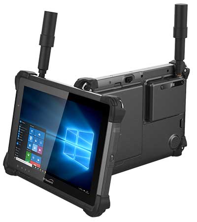
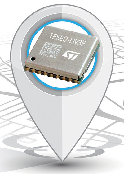
    • Multi-frequency GNSS (including GPS, GLONASS, Galileo and BeiDou)
    • External GNSS antenna capable
    • Intel RealSense Depth camera, 2D barcode scanner
    • Long-range Bluetooth, 4G LTE, digital pen support
    • Sturdy external keyboard with various mounts for static installation
    • Rugged yet reasonable weight of 3.1 pounds
    • Multiple mounting options for precise measurement

    Rugged, but not too heavy

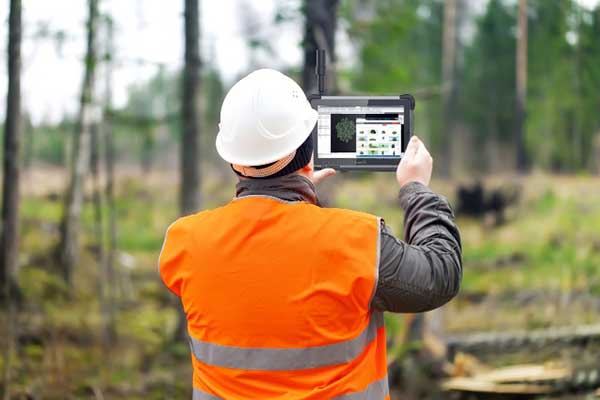
    The first impression a new user of the DT301X-TR will notice is that while it is heavier than the normal personal tablet, it is very rugged yet not noticeably heavy. The additional weight it does carry, however, gives the user a sense of durability and confidence to take it into fouler environments without fear of infiltration or hazardous climate concerns.

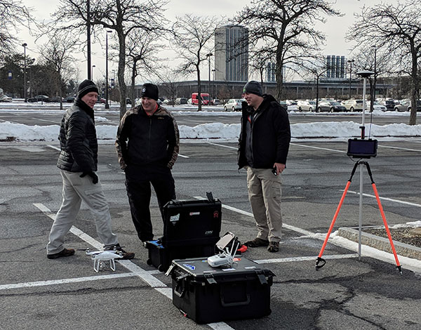
    The external bumpers can take significant abuse, and the rubber rear guard is used for gripping the tablet effectively during data collection tasks. Several mounts are available for this unit, including a pole mount in conjunction with the external GNSS antenna for higher accuracy location determination.

    This unit runs the Microsoft Windows 10 IoT (internet of things) Enterprise operating system, so most users will already have a general feel for the overall interface. All the normal Windows tools are there (email, browser, etc.), so little training is needed for beginners.

    Connectivity is available through dual-band Wi-Fi and/or 4G LTE communications as well as long-range Bluetooth connections where needed. The unit runs on an Intel 8th-generation core processor and SSD storage for fast computing and data access needs.

    In addition to computing performance, this model also exceeds expectations with its robust screen. Where most high-def screens on phones and tablets suffer in daylight conditions, the DT301X-TR allows the user to maintain great visibility and keep working with visual confidence.

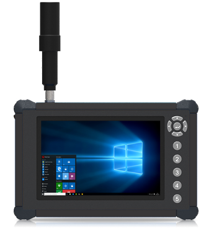
    GNSS module and antenna

    The DT301X-TR can be loaded with several data-collection software packages, depending on your application. For traditional surveying, Microsurvey’s Field Genius is used for locating survey points with the GNSS module. Several programs for data collection are available, depending on the accuracy required by the user.

    Photo: DT Research
    Photo: DT Research

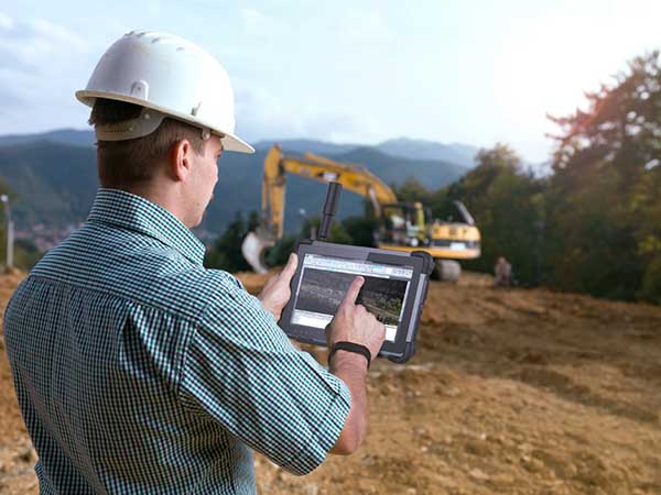
    A helical mobile dual-frequency GNSS antenna is mounted directly on the tablet for receiving survey-grade positions with an RTK correction service. The tablet can also be used with an external GNSS antenna mounted on an extendable pole for a more conventional surveyor-style method of data collection while providing stability for the user.

    The data-collection process for mapping is intuitive and allows for uploading existing shapefiles for reference to existing conditions. Exporting information after the data-collection task can be completed in two different formats: shapefiles and KML files.

    Photo: DT Research
    Photo: DT Research

    For the higher accuracies typically required for surveyors, the unit utilizes the pole mount to ensure the accuracy level is not compromised by human interaction, and it connects to an external GNSS antenna. The software allows the user to collect more precise locations through several means: static, real-time kinematic from the user’s base station, or through a real-time network solution from an external source.

    The data collection process in Field Genius is very user friendly and allows for customized point naming and automatic linework between points. Field Genius also contains standard COGO tools and routines that allow the user to perform field calculations right on the job, saving valuable time and money for the practitioner and the client.

    Exporting of field data is robust and allows for creation of DXF/DWG files of linework and LandXML files for surface and point downloads. The user can also export raw data in a GNSS Survey format or the industry standard “field book” format as well. Importing background files is just as simple, so the user can have additional information at their fingertips for reference during their data collection process.

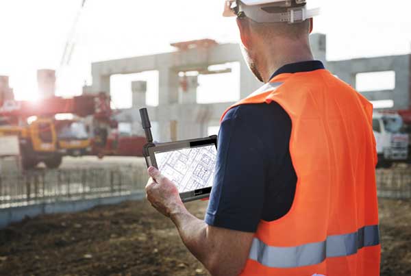
    Also, the DT301X-TR can be utilized for construction staking with an extensive array of staking reports available for user verification. Proposed TIN surface models can be imported for site and roadway staking for placing cut/fill points on the fly.

    Cameras make it shine

    The DT301X-TR, however, is not just a fancy conventional surveying data collector; the Intel RealSense Depth camera and DOT3D Pro software from DOT Product is the latest development to be added to the rugged tablet that makes this platform shine. This latest technology from Intel allows the user to photograph and video spaces that even the newest laser and lidar scanning equipment can’t access.

    Stereo depth modeling is enhancing the data-collection process for surveyors as a new tool to collect important information for engineers, architects and contractors. By collecting close quarters information in real time, a more complete BIM and/or “digital twin” data set can be accomplished faster and more cost efficiently than ever.

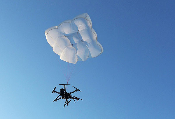
    This version of remote sensing is becoming very popular with other vehicles and platforms (such as UAVs), yet being integrated into a single unit with GNSS capability is key to making the DT301X-TR a game changer.

    The divide between the macro (GIS mapping) and micro (traditional surveying) of spatial data collection is closing, but it will take some time before satisfying the surveying community. The DT301X-TR is closing that gap by marrying the accuracy of GNSS measurement with the precision of 3D analyzation technology.

    DT Research began by creating a bulletproof tablet made for durability and dependability, but has raised the bar with a state-of-the-art satellite measurement module and remote-sensing capability through the RealSense camera system.

    Wrapping all this technology into a rugged unit running on an industry-standard software platform, DT Research has provided an insight to what the future of data collection looks like, no matter what profession one is in.

  • Rugged tablet offers 3D imaging for field work

    Rugged tablet offers 3D imaging for field work

    Photo: DT Research
    Photo: DT Research

    DT Research has designed a new rugged tablet with 3D imaging that is purpose-built for 3D mapping with a built-in GNSS module.

    The DT301X has an Intel RealSense Depth camera that provides real-time 3D imaging combined with dual-frequency GNSS module for real-time mapping and positioning. The digital images are better than high-definition standard, and are suitable for construction building information management (BIM) graphics.

    The DT301X rugged tablet is compatible with existing applications with Microsoft Windows 10 IoT Enterprise operating systems for flexible integration, and it brings together the advanced workflow for data capture, accurate positioning and data transmitting.

    Key features of the DT301X

    • Highly durable. IP65 and MIL-STD-810G rated tablet in a slim case offers the versatility to be used in the field, office and vehicles.
    • Indoor/outdoor display. A high brightness 10.1-inch touchscreen offers flexible viewing in a wide range of lighting.
    • Wi-Fi and Bluetooth. Long-range Bluetooth for 1000-foot range and 4G LTE mobile broadband for the latest in high-speed communications.
    • High performance. Intel 8th-generation Core i5 or i7 processor offers high-performance while still being energy efficient.
    • Hot-swappable batteries. With high-capacity 60- or 90-watt hot-swappable batteries, the DT301X keeps working continuously.
  • Rugged tablet designed for accurate real-time measurements

    Rugged tablet designed for accurate real-time measurements

    RealSense 3D Camera is Fully Integrated to Capture Detailed Images

    DT301X-TR rugged tablet. (Photo: DT Research)
    DT301X-TR rugged tablet. (Photo: DT Research)

    DT Research is offering the new DT301X-TR rugged tablet, a lightweight military-grade tablet. The tablet is purpose-built to enhance the precision for bridge and construction inspections, 3D surveying and mapping of underground utilities.

    The DT301X-TR provides multi-frequency GNSS real-time kinematic (RTK) with carrier phase for mapping and positioning, and supports GPS, GLONASS, BeiDou, Galileo and QZSS.

    The optional foldable antenna supports high-accurate measuring field work, which can be measured with RTK GNSS positioning directly, or used to connect to an external antenna for higher precision.

    Its 10.1-inch high-brightness capacitive touch screen can be read in a wide range of lighting indoors and outdoors. The tablet comes with a choice of Intel 8th-generation Core i5 or i7 processors. Its MIL spec and IP ratings means it holds up to real-world hazards and performs in many industries and environments.

    Integrated 3D camera. The DT301X-TR integrates the optional Intel RealSense Depth camera which provides real-time 3D imaging to quickly and accurately create measurements for CAD, engineering, design, utility and project management, and crime/crash scene forensics. Scientific grade data, which is important for evidence as well as building plans, is now easier to access and use for specialists and non-credentialed workers alike.

    With this 3D camera technology, depth perception is integrated to add the most accurate image to make projects stay factual and consistent. The integration of the 3D camera with a rugged handheld tablet improves the mobility and reduces the bulk and limitations of a laser scanner for small, hard-to-reach spaces and brings the measurement, real- time scanning, and positioning together in one device which can also be used to process and transmit the data.

    Using rugged tablets with 3D technology allows the as-built status of a project to be tracked and documented in real time, reducing the project cycle time, and also allows data to be shared with the owner, general contractor and subs as it is captured. This boost to efficiency and accuracy validation shortens payment cycles as well as improving the overall BIM (building information modeling), getting infrastructure going quickly and getting payments to contractors faster.

    “The combination of the DT Research rugged tablet with the RealSense depth camera and DotProduct’s Dot3D Pro software enables projects to be quickly set up, tracked, and completed for all staff and tasks whether in the office or on the site. The ease of use these tools bring to 3D workflows can benefit a wide range of applications from construction verification to asset management to crime scene mapping.” says Tom Greaves, chief marketing officer at DotProduct.

    Data capture options besides the 3D camera are a 2D barcode scanner for equipment/location tags, long-range Bluetooth for 1,000-foot range suitable for connecting to robotic total stations and 4G LTE mobile broadband for the latest in high speed communications.

    The flexibility for set up and use is enhanced in the DT301X-TR rugged tablet with Microsoft Windows 10 IoT Enterprise operating systems for convenient integration with existing applications, bringing together the advanced workflow for data capture, accurate positioning and data transmitting.

    Another option is a bright LED light that can be attached to the DT301X-TR and stay consistently on for up to two hours, bringing light to underground infrastructure mapping and scanning.

    With high capacity 60 or 90 watt hot-swappable batteries, the rugged yet lightweight DT301X-TR keeps working continuously whether in the field, office, or vehicles, complemented with a variety of battery chargers so fully charged batteries are always available.

    This rugged tablet gives detailed accuracy combined with the latest 3D camera technology all in one tablet that is rugged and easy to use in the field. Whether at the construction site, mapping underground utilities, or at the freeway crash scene, the cost-effective DT301X-TR is ideal for accurate measurements to enable data-driven decisions, able to travel to wherever the work is.

    The DT301X-TR rugged tablet will be available in May 2019 from DT Research’s authorized resellers and partners. DT Research will be at booth 217 at AEC’s BuildTech show.

  • Oregon transportation expands use of GNSS tablets

    Oregon Department of Transportation workers use DT Research’s GNSS rugged tablets. (Photo: DT Research).
    Oregon Department of Transportation workers use DT Research’s GNSS rugged tablets. (Photo: DT Research).

    The Oregon Department of Transportation (ODOT) has expanded its use of DT Research GNSS rugged tablets to all 15 of its construction management offices across the state, and also use the tablets for biology, geology, roadway and wetland projects.

    DT Research worked closely with ODOT to design purpose-built rugged tablets that empower state workers to easily collect and transmit geospatial measurements in the field using GNSS real-time kinematic (RTK) technologies.

    “DT Research’s GNSS rugged tablets have enabled us to bring high-accuracy geospatial measurements to workers across the Department of Transportation, which has literally changed the way we work,” said Chris Pucci, construction automation surveyor at ODOT. “The tablets have enabled us to save time, reduce costs and improve the accuracy of projects through ‘digital-as constructed’ measurements and real time data capture.”

    The tablets have a dual-frequency GNSS module built in, which provides stand-alone sub-meter accuracy to centimeter-level accuracy with RTK from GPS, GLONASS and Galileo satellites.

    The tablets are compatible with existing survey and GIS software for mapping applications and provide an advanced workflow for data capture, accurate positioning and data transmitting.

    “We now have essentially created one-person survey crews because the DT Research tablets are so much easier to use than a tape measure and paper to accurately calculate and record measurements during complex construction projects,” Pucci said. “Using the tablets saves us an average of $2,000 for every survey-grade measurement job that does not require a full survey crew.”

    “In addition, the tablets have provided us with a contract verification system by having highly accurate digital-as-constructed measurements that are delivered immediately and stored forever, which saves the state time and money by avoiding independent re-measurement checks due to billing discrepancies at the end of a project,” added Pucci.

    The DT Research GNSS tablets can store up to 1 Terabyte of data for field data collecting. Users can avoid down time with a high-capacity hot-swappable battery pack, which delivers 60 or 90 watts for up to 15 hours of continuous mobile communications. The units include Long Range Class 1 Bluetooth, which powers wireless connectivity up to 1,000 feet and 4G mobile broadband.

    “The simplicity of how the DT Research tablets work is amazing,” Pucci said. “Unlike complex professional survey equipment, the DT Research tablets are a Windows-based mobile device with a user interface that is familiar to workers. In just two hours, I can easily train state workers with diverse skill sets to measure quantity, linear features and volumes for a variety of projects — and they are ready to go.”

    The tablets run on Microsoft Windows 7 Professional or Windows 10 IoT Enterprise and are high performance devices with an Intel 6th or 8th Generation Core i5 or i7 processor. The rugged tablet is designed for outdoor use with a brilliant LED-backlight, 800 nits sunlight-readable screen and capacitive touch.

    “We have found the DT Research tablets to be incredibility easy to manage and highly durable — we just turn them on and they work,” said Pucci. “In the three years that we have used the tablets, we have had very few technical support questions and they hold up well in different weather conditions. There isn’t a comparable product on the market at the price point.”

    The DT Research tablets are military-grade durable devices, yet lightweight, offering the versatility to be used in field-to-office settings. For use in harsh environments, the tablet is fully ruggedized to meet the highest durability standards with an IP65 rating, MIL-STD-810G for vibration and shock resistance and MIL-STD-461F for EMI and EMC tolerance.

    For use in a variety of environments, the tablets are complemented by many accessories including: external antennas, pole mount cradles, detachable keyboards, battery charging kits and digital pens.

  • Launchpad: GNSS firewall, drone rescue, modules and mappers

    Launchpad: GNSS firewall, drone rescue, modules and mappers

    A roundup of recent products in the GNSS and inertial positioning industry from the November 2018 issue of GPS World magazine.

    OEM

    Simulator signals

    GPS L5 and Galileo E5 added to simulator

    Rohde & Schwarz adds GPS L5 and Galileo E5 simulation capabilities to the R&S SMW200A GNSS simulator. (Photo: R&S)
    Photo: Rohde & Schwarz

    Rohde & Schwarz has added GPS L5 and Galileo E5 simulation capabilities to its R&S SMW200A GNSS simulator. The R&S SMW200A GNSS simulator is designed for efficient test and characterization of multi-constellation and multi-frequency GNSS receivers. It now enables generation of complex and highly realistic test scenarios with up to 144 channels in the GNSS frequency bands L1, L2 and L5. In addition to GPS (L1/L2/L5), GLONASS (L1/L2), Galileo (E1/E5) and BeiDou (L1/L2), the R&S SMW200A also supports signal generation for QZSS and SBAS on L1. Channels can be routed to up to four RF outputs, so that even multi-antenna systems can be tested. The R&S SMW200A can generate complex coexistence and interference scenarios with multiple interferers.

    Rohde & Schwarz, rohde-schwarz.com

    GNSS firewall

    Provides secure, continuous timing integrity

    The BlueSky GNSS Firewall enables critical infrastructure providers to harden the security of their operations from GPS threats and deliver a more reliable and secure service. The security-hardened system provides protection against GPS threats such as jamming, spoofing and complete outage. It also supports a range of precision timing technologies, including atomic clocks, to enable continuous operation when GPS may be completely denied for extended periods. The TimePictra software management suite provides centralized control and visibility of GPS reception across regional, national and global geographic areas. It can incorporate an optional internal miniature atomic clock.

    Microsemi, microsemi.com

    GNSS antenna

    For reference deployments, CORS networks and monitoring

    The VeraChoke GNSS antenna. (Photo: Tallysman)
    The VeraChoke GNSS antenna. (Photo: Tallysman)

    The VeraChoke is a high-accuracy choke ring antenna with a choice in form factor for reference and monitoring applications. The VC6100, the first model variant of the VeraChoke, shares a common high-efficiency element design with its counterpart VeraPhase. With the choke-style form-factor, however, the rings have been optimized for all GNSS signals and are slightly pyramidal in shape to improve reception of low-elevation satellites. The VC6100 offers a tight phase center variation (PCV) of no more than ±1 mm for every frequency. It is capable of receiving all GNSS signals, and achieves a very low axial ratio. The antenna also supports large and small SCIGN radomes.

    Tallysman, www.tallysman.com

    GNSS + INS module

    Combination improves availability

    Duro Inertial fuses GNSS and inertial measurements into a combined solution. (Photo: Swift Navigation)
    Photo: Swift Navigation

    Duro Inertial is a ruggedized version of Swift Navigation’s Piksi Multi dual-frequency real-time kinematic (RTK) GNSS receiver combined with Carnegie Robotics’ SmoothPose sensor fusion algorithm, which fuses GNSS and inertial measurements into a combined solution. The blending of GNSS and inertial measurements provides a dead-reckoning capability that allows Duro Inertial to provide a highly accurate, continuous position solution during brief GNSS outages and to deliver a robust precision navigation solution in harsh GNSS environments.

    Swift Navigation, www.swiftnav.com; Carnegie Robotics, carnegierobotics.com

    Smartwatch

    Features GPS, GLONASS and Galileo

    Photo: Garmin
    Photo: Garmin

    The durable Instinct has GNSS; three-axis compass; barometric altimeter; and wrist-based heart-rate sensor. The watch includes a built-in sports apps, smart connectivity and wellness data. It is built to endure challenging environments, and is constructed to military standards for thermal, shock and water resistance. The multi-GNSS feature helps users track their location in challenging environments, while the Garmin Explore app helps plan and track a trip.

    Garmin, garmin.com

    SURVEY & MAPPING

    Navigation system

    GNSS + inertial for surveying

    Photo: SBG Systems
    Photo: SBG Systems

    The Navsight Land & Air Solution provides high-performance inertial navigation to make surveyors’ mobile data collection easier, whether for mobile mapping, GIS or road inspection. The solution consists of an inertial measurement unit (IMU), available at two different performance levels, connected to Navsight, a rugged processing unit embedding fusion intelligence and a GNSS receiver. It also has connections for external equipment such as lidar, cameras or computer. SBG’s fusion algorithms allow the company to get the best performance from inertial, odometer and GNSS technologies; exclude false GNSS fixes; and improve the trajectory in complicated areas such as urban canyons, forests and tunnels. The solution supports all GNSS constellations, and real-time kinematic (RTK) and precise point positioning services such as Omnistar and TerraStar.

    SBG Systems, www.sbg-systems.com

    Mapper

    Edge-to-cloud big data system

    iSTAR Pulsar is designed to capture 360-degree data while mounted on a vehicle, drone or on foot. An upcoming feature in cloud-based processing software VR.WORLD uses artificial intelligence and image recognition to analyze the images captured by iSTAR Pulsar so that objects like cars, trucks, traffic lights, road signs, pedestrians and cyclists can be automatically identified in images. Handheld 3D mobile mapping company GeoSLAM and mobile mapping software company Orbit GT have introduced integration with iSTAR Pulsar.

    NCTech, www.nctechimaging.com

    Smart antennas

    Offers L-band access to TerraStar

    Photo: NovAtel
    Photo: NovAtel

    The SMART7 family features NovAtel’s GNSS + inertial navigation system (INS) SPAN technology; future-ready GNSS; Wi-Fi and internet protocol connectivity; superior tracking performance; and TerraStar-C PRO corrections. It is designed to increase GNSS availability, accuracy and reliability for major precision-agriculture equipment manufacturers. The SMART7-S includes SPAN technology, the SMART7-W includes Wi-Fi and an integrated NTRIP client, and the SMART7-I model also incorporates Ethernet. All SMART7 models provide exceptional positioning availability using signals from all constellations and frequencies to deliver assured positioning anywhere.

    NovAtel, www.novatel.com

    Rugged tablet

    For high-accuracy measurements

    Photo: DT Research
    Photo: DT Research

    The DT301X rugged military-grade tablet is purpose-built to enhance the precision of 3D surveying, crime and crash scene reconstruction, and bridge and other construction inspections. An option is a dual-frequency GNSS module for real-time mapping and positioning. The tablet integrates the Intel RealSense depth camera, which provides real-time 3D imaging providing accurate measurements for CAD, engineering, design, utility management and crime-scene forensics. A high brightness 10.1-inch touchscreen offers flexible viewing in a wide range of lighting, and an Intel eighth-generation Core i5 or i7 processor offers high-performance while still being energy efficient. With high-capacity 60- or 90-watt hot-swappable batteries, the DT301X keeps working continuously, complemented with a variety of battery chargers so fully charged batteries are always available.

    DT Research, www.dtresearch.com

    Rugged smartphone

    For data collection

    Photo: Juniper Systems
    Photo: Juniper Systems

    The Cedar CP3 rugged smartphone is capable of data collection and communication. It has a high-visibility 5.5-inch AMOLED display; 14- to 16-hour battery life operating at full brightness and running GPS; 16-megapixel user-facing camera and dual 12-megapixel rear camera; and 6 gigabytes of RAM with 64 gigabytes of internal storage.

    Juniper Systems, www.junipersys.com

    UAV

    Drone rescue system

    Parachute systems for multicopters

    Photo: Drone Rescue
    Photo: Drone Rescue

    Parachute rescue system DRS-5 is designed for multicopters up to 8 kg; the DRS-10 for multicopters weighing 5–20 kg. The system consists of a carbon cage in which the parachute is stored as well as associated electronics. The electronics, including the sensors, monitor the flight status of a drone independent of the flight controller. A sophisticated algorithm merges this sensor data, enabling automatic crash detection and parachute ejection. All flight data and movements are recorded in a black box.

    Drone Rescue, www.dronerescue.com

    UAV data analysis tool

    New analytics tool for drone pilots

    PrecisionPass assesses UAV data collected in the field. The toolkit lets pilots quickly determine if a data-collection job meets the required criteria or if it needs to be collected again. PrecisionPass assesses coverage, assesses image resolution and quality, reviews required metadata, speeds upload and processing times, and packages data for processing. The immediate feedback reduces the risk of failures during the analysis stage, all but eliminating the need to re-fly a mission, so customer needs are met in a timely and cost-efficient manner.

    Harris Geospatial, www.harrisgeospatial.com

    Computing platform

    Automates commercial drone tasks

    The Skyfish platform is controlled by the tiny SkyNode computer, which integrates with optical, thermal, navigational and lidar devices along with sensors, algorithms and robotics. (Photo: Skyfish)
    Photo: Skyfish

    The Skyfish computing platform fully automates crucial infrastructure inspection and measurement tasks. It supports DJI and PixHawk flight controllers and other drone architectures, as well as 3D modeling software from companies such as Bentley Systems. Its easy-to-use interface enables anyone to fly, inspect and model complex infrastructure. The platform also pre-processes the collected infrastructure data and metadata to help create impeccable 3D models.

    Skyfish, www.skyfish.ai

    TRANSPORTATION

    Development kit

    Open-source GNSS+IMU kit for autonomous guidance

    Photo: Aceinna
    Photo: Aceinna

    OpenIMU is a professionally supported, open-source GPS/GNSS-aided inertial navigation software stack for low-cost precise navigation applications. Integrating an inertial measurement unit (IMU)-based sensor network improves navigation and self-location capabilities. It is aimed at developing autonomously guided vehicles for industrial applications, autonomous cars, industrial robots and drones. OpenIMU enables advanced localization and navigation algorithm solutions; its extensible software infrastructure provides the code needed for algorithm development. A hardware development kit includes JTAG-pod, precision mount fixture, EVB and an OpenIMU300 module that features Aceinna’s 5 deg/hr, 9-Axis gyro, accelerometer and magnetometer sensor suite with an onboard 180-MHz ARM Coretex floating-point CPU.

    Aceinna, aceinna.com

    GNSS module

    Leverages the Teseo III receiver

    Image: STMicroelectronics
    Image: STMicroelectronics

    The Teseo-LIV3F module incorporates the Teseo III receiver. It speeds application development and adds up to 16 MB of Flash memory for firmware updating or data logging without a backup battery. Used by automotive and industrial sectors, the Teseo III multi-constellation receiver combines high accuracy with fast response time and low power consumption. The Teseo-LIV3F module enables makers and small engineering teams to leverage the Teseo III advantages in creating new products in the industrial and consumer market segments such as vehicle trackers, drones, anti-theft devices and pet locators, and systems for services such as fleet-management, tolling, vehicle sharing or public transportation.

    STMicroelectronics, www.st.com

    Digital mirrors

    Coming to Europe in late 2018

    Photo: Ficosa
    Photo: Ficosa

    Audi’s latest e-tron electric car will launch in Europe with a digital rear-view system. Developed by Ficosa, the camera monitoring system is made up of cameras and displays that replace traditional external side mirrors to increase safety and comfort. The vision system is comprised of two cameras, integrated into the sides of the car’s chassis, and two tactile displays inside the doors.

    Ficosa, www.ficosa.com; Audi, www.audi.com

  • Rugged tablet purpose-built for high-accuracy measurements

    Rugged tablet purpose-built for high-accuracy measurements

    RealSense 3D camera is fully integrated to capture real-time detailed images

    DT301X rugged tablet. (Photo: DT Research)
    DT301X rugged tablet. (Photo: DT Research)

    DT Research has released the DT301X rugged tablet, a lightweight military-grade tablet that is purpose-built to enhance the precision of crime and crash scene reconstruction, bridge and other construction inspections, and 3D surveying.

    DT Research made the announcement at Intergeo, being held Oct. 16-18 in Frankfurt, Germany.

    The DT301X rugged tablet has MIL spec and IP ratings, yet is lightweight — offering the versatility to be used in the field, office and vehicles, the company said. A high brightness 10.1-inch touchscreen offers flexible viewing in a wide range of lighting, and an Intel eighth-generation Core i5 or i7 processor offers high-performance while still being energy-efficient.

    With high-capacity 60- or 90-watt hot-swappable batteries, the DT301X keeps working continuously, complemented with a variety of battery chargers so fully-charged batteries are always available.

    The DT301X integrates the Intel RealSense depth camera, which provides real-time 3D imaging to shorten the workflow and create extremely accurate measurements for CAD, engineering, design, utility management and crime-scene forensics.

    Scientific grade data, which is important for court evidence as well as building plans, just got easier and is now available to a wider group of workers. With this 3D camera technology, depth perception is integrated to add the most accurate image to make projects stay factual and consistent, DT Research said.

    Optional data capture offered on the DT301X besides the 3D camera are a 2D barcode scanner for equipment/location tags, a dual-frequency GNSS module for real-time mapping and positioning, long-range Bluetooth for 1000-foot range, and 4G LTE mobile broadband for the latest in high speed communications.

    The rugged tablet gives detailed accuracy combined with the latest 3D camera technology all in one device that is rugged and easy to use in the field.

    “DT Research’s high-performance rugged tablet equipped with the RealSense depth camera combined with DotProduct’s Dot3D Scan software allows speedy and efficient field-to-office 3D workflows for a wide range of applications from construction verification to asset management to crime scene mapping,” said Tom Greaves, chief marketing officer at DotProduct.

    The DT301X is built to operate in real-world situations, with an IP65 rating for water and dust, MIL-STD-810G for shock and vibration protection, and MIL-STD-461F for EMI and EMC tolerance. The tablet can be paired with a detachable keyboard for ease of use, and Wi-Fi and Bluetooth for smooth networking and constant communications.

    The DT301X rugged tablet is compatible with existing applications with Microsoft Windows 10 IoT Enterprise operating systems for flexible integration, and it brings together the advanced workflow for data capture, accurate positioning and data transmitting.

    Whether at the electrical substation, at the crash scene, or at the construction site, the DT301X is ideal for accurate measurements as well as other needed tasks, able to travel to wherever the work is.

    The DT301X rugged tablet will be available in November 2018 from DT Research’s authorized resellers and partners.

  • DT Research’s newest tablet provides scientific-grade GNSS

    DT Research’s newest tablet provides scientific-grade GNSS

    Photo: DT Research
    Photo: DT Research

    DT Research has launched the DT372AP-TR rugged real-time kinematic (RTK) tablet, a lightweight military-grade tablet that offers RTK to enhance the precision of position data derived from satellite-based positioning systems.

    The tablet enables 3D point cloud creation with centimeter-level accuracy to meet the high standards required for scientific-grade evidence in court, the company said.

    The DT372AP-TR RTK tablet is military-grade with an IP65 rating, yet lightweight — offering the versatility to be used in the field, office and vehicles.

    A dual-frequency GNSS module is built into the tablet, which uses real-time reference points within 1- to 2-centimeter accuracy to position 3D point clouds created from aerial photogrammetry, using GPS, GLONASS and Galileo satellites. Users can measure with the RTK GNSS positioning directly using an external antenna for better survey-grade precision.

    “We designed a more compact tablet that still offers all the functionality of a rugged RTK tablet, to give ultra-mobility to law enforcement and first responders who are already weighed down with heavy equipment,” said Daw Tsai Sc.D., president of DT Research. “With programmable side buttons and directional pad, this tablet combines ease of use with a small form factor and centimeter level accuracy, there is nothing in the market now in the same category that can offer this combination.”

    The DT372AP-TR RTK tablet is compatible with existing survey and GIS software for mapping applications and brings together an advanced workflow for data capture, accurate positioning and data transmitting.

    The tablet can be used in a variety of scenarios, including:

    Forensic mapping. Public safety teams, investigators and crash reconstructionists can use the DT372AP-TR to accurately collect measurements that are scientifically and legally defensible by using the real-time centimeter reference points to position 3D point clouds created from aerial photogrammetry or take stand-alone measurements. By using the tablet with a drone for crime and crash scene investigation, cost goes down while accuracy and speed improve, helping to clear areas faster, thereby improving overall public safety.

    Land surveying. Surveyors can use the DT372AP-TR RTK tablet to measure the altitudes, angles and distances on the land surface so that they can be accurately plotted on a map to determine property boundaries, construction layout and mapmaking.

    E-construction. Construction workers can manage the collection, review, approval and distribution of highway construction contract documents in a paperless environment using the DT372AP-TR RTK tablet.

    The tablet has been purpose-built for precision mapping in a variety of environments and includes the following features and capabilities:

    • Dual-frequency GNSS module. GNSS L1 and L2 RTK that receives GPS, GLONASS, Galileo, BeiDou and QZSS signals up to 372 channels
    • High-performance CPU and Windows OS. Intel Pentium processor with Microsoft Windows 10 IoT Enterprise with 8 GB of RAM.
    • Brilliant sunlight-readable display. A 7-inch LED-backlight, high-brightness (800 nits) sunlight-readable screen with capacitive touch and 1280 x 800 resolution.
    • Superior wireless connectivity. Long-range Class 1 Bluetooth option powers connectivity up to 1,000 feet.
    • Mobile broadband option. For best field connectivity, there is an option for 4G mobile broadband for LTE, HESPA+, GMS/GPRS/EDGE, EV-DO, Rev A and 1xRTT.
    • Military standards. For use in harsh environments, the tablet is fully ruggedized to meet the highest durability standards with an IP65 rating, MIL-STD-810G for vibration and shock resistance and MIL-STD-461F for EMI and EMC tolerance.
    • High-capacity hot-swappable battery pack. Delivers 60 or 90 watts for up to 15 hours of continuous mobile communications.
    • Camera option. The optional back camera offers 5 megapixels, CMOS sensor and auto focus to capture project progress or record crash and crime scene details.
    • Accessories. External antennas, pole mount cradles, battery charging kits and digital pens.
  • DT Research’s new military-grade tablet has RTK GNSS

    DT Research’s new military-grade tablet has RTK GNSS

    DT Research has released the DT301T rugged RTK tablet (DT301T-RTK), a lightweight military-grade tablet purpose-built for GIS mapping applications. It features real-time kinematic (RTK) satellite navigation to enhance the precision of GNSS position data.

    The tablet enables 3D point cloud creation with centimeter-level accuracy, meeting the high standards required for scientific-grade evidence in court.

    The DT301T-RTK is a rugged tablet with scientific-grade GNSS. (Photo: DT Research)

    The DT301T Rugged RTK tablet is military-grade with an IP65 rating. Because it’s lightweight, the DT301T can be used in the field, office and vehicles, the company said.

    A dual-frequency GNSS module is built into the tablet, which uses real-time reference points within 1–2-centimeter accuracy to position 3D point clouds created from aerial photogrammetry, using GPS, GLONASS and Galileo receivers. Users can measure with the RTK GNSS positioning directly using a foldable antenna or connect to an external antenna for more robust receiving and survey-grade precision.

    “We’ve seen a dramatic uptick in the need for rugged tablets to be purpose-built for a range of mapping uses across industries,” said Daw Tsai Sc.D., president of DT Research. “In designing the DT301T with RTK satellite navigation, we also took into consideration the other features and capabilities necessary within a rugged tablet to quickly and easily conduct forensic mapping, land surveying, e-construction, building information modeling (BIM) and other mapping scenarios.”

    The DT301T is compatible with existing GIS software for mapping applications and brings together the advanced workflow for GIS data capture, accurate positioning and data transmitting.

    Uses

    According to DT Research, the tablet can be used in a variety of scenarios.

    Forensic mapping. Public safety teams, investigators and crash reconstructionists can use the DT301T Rugged RTK tablet to accurately collect measurements that are scientifically defensible by using the real-time centimeter reference points to position 3D point clouds created from aerial photogrammetry or take stand-alone measurements.

    DT301T-RTK tablet during forensic mapping training. (Photo: DT Research)

    The results will have the precision necessary to stand up as evidence in court, said Andrew S. Klane, a former Massachusetts State Police Lieutenant who teaches Forensic Mapping and is now the chief operating officer at Forensic Mapping Solutions Inc.

    “As more drones are being used for mapping, there is a growing need for ground-control positioning devices,” Klane said. “By using a DT301T Rugged RTK Tablet in combination with a drone, users can more quickly and cost-effectively create a 3D model to deliver an accurate representation of the scene with scientific-grade tolerance that will hold up in a court of law.”

    It could also help clear crash scenes faster, restoring the normal flow of traffic on congested roadways, reducing secondary crashes and lowering the chance of first responders and other workers getting hurt while clearing the scene.

    Land surveying. Surveyors can use the DT301T tablet to measure the altitudes, angles and distances on the land surface so that they can be accurately plotted on a map to determine property boundaries, construction layout and mapmaking.

    E-construction. Construction workers can manage the collection, review, approval and distribution of highway construction contract documents in a paperless environment using the DT301 tablet.

    Building information modeling (BIM).  Architecture, engineering, and construction (AEC) professionals can use the tablet to create 3D models to efficiently plan, design, construct and manage buildings and infrastructure.

    FEATURES

    The DT301T Rugged RTK tablet has been purpose-built for precision mapping in a variety of environments and includes the following features and capabilities:

    • Dual-frequency GNSS module: GNSS L1 and L2 RTK that receives GPS, GLONASS and Galileo signals up to 372 channels with RMS 10 mm + 1 ppm accuracy.
    • High-performance CPU and Windows OS: Intel 6th-generation core i5 or i7 processor with Microsoft Windows 7 Professional or Windows 10 IoT Enterprise. Units come with either 8 GB or 16 GB of RAM.
    • Sunlight-readable display: A 10.1 inch LED-backlight, sunlight-readable screen with capacitive touch and 1920 x 1200 resolution.
    • Wireless connectivity: Long-range Class 1 Bluetooth powers connectivity up to 1,000 feet and 4G mobile broadband for LTE, HESPA+, GMS/GPRS/EDGE, EV-DO, Rev A and 1xRTT.
    • Storage: For field data collecting, the tablet can store up to 1 terabyte of data.
    • Military standards: The tablet is fully ruggedized to meet the highest durability standards with an IP65 rating, MIL-STD-810G for vibration and shock resistance, and MIL-STD-461F for EMI and EMC tolerance.
    • Battery pack: High-capacity hot-swappable battery pack delivers 60 or 90 watts for up to 15 hours of continuous mobile communications.
    • Accessories: Those available include external antennas, pole mount cradles, detachable keyboards, battery charging kits and digital pens.
  • Oregon moves to tablets for no-stake 3D

    Oregon moves to tablets for no-stake 3D

    The Oregon Department of Transportation (ODOT) is embracing the growing trend in highway construction to go “stakeless” and push to full 3D design.

    With more contractors using automated machine guidance applications, ODOT’s construction personnel are being asked to inspect projects with fewer stakes and visual indicators for line and grade. Employees are seeking to use the same data and information to determine line and grade when building or fixing stretches of road.

    ODOT inspectors Jorge Jimenez and Mike Stennett at Multnomah Falls, preparing for a night-time paving operation. (Photo: Chris Pucci)
    ODOT inspectors Jorge Jimenez and Mike Stennett at Multnomah Falls, preparing for a night-time paving operation. (Photo: Chris Pucci)

    To address this need, rugged tablet maker DT Research worked closely with ODOT to design purpose-built Inspector Positioning Tablets that run GPS locating and 3D modeling applications, and take advantage of the Oregon Real-Time GNSS Network.

    “MicroSurvey Field Genius surveying software is used to read XML files directly, allowing the inspector to work with the same files that the contractors received from the roadway designers,” said Chris Pucci, ODOT Construction Automation Surveyor.

    The tablets enable ODOT to fully use its knowledge of the Oregon Real-Time GNSS Network and expertise in survey-grade RTK GNSS to achieve accuracies of +/0.05 feet.

    The model DT391GS tablets have 9-inch touchscreens. The tablets can be used as handhelds or with an external antenna and pole. ODOT purchased one of four GNSS options offered by DT Research for the DT391GS tablets. The options enable inspectors and construction crews to employ a combination of GPS locating and 3D modeling to guide construction workers.

    The goal is to allow the inspectors to make the same checks they would have made if there had been traditional construction staking on a project, not to make inspectors into surveyors, Pucci noted.

    A one-day training is provided to train construction personnel before they are issued a tablet. “The tablets have been very well received by our construction inspection personnel,” he said.

    The tablet project is now in the pilot phase with 20 tablets deployed to eight construction offices and more than 70 construction personnel having been trained. “We also just placed an order for 22 more tablets for the upcoming 2017 construction season,” Pucci said.

  • Oregon moves to tablets for no-stake 3D design

    The Oregon Department of Transportation (ODOT) is embracing the growing trend in highway construction to go “stakeless” and push to full 3D design.

    With more contractors using automated machine guidance applications, ODOT’s construction personnel are being asked to inspect projects with fewer stakes and visual indicators for line and grade. Employees are seeking to use the same data and information to determine line and grade when building or fixing stretches of road.

    ODOT inspectors Jorge Jimenez and Mike Stennett at Multnomah Falls, preparing for a night-time paving operation. (Photo: Chris Pucci)
    ODOT inspectors Jorge Jimenez and Mike Stennett at Multnomah Falls, preparing for a night-time paving operation. (Photo: Chris Pucci)

    To address this need, rugged tablet maker DT Research worked closely with ODOT to design purpose-built Inspector Positioning Tablets that run GPS locating and 3D modeling applications, and take advantage of the Oregon Real-Time GNSS Network.

    “MicroSurvey Field Genius surveying software is used to read XML files directly, allowing the inspector to work with the same files that the contractors received from the roadway designers,” said Chris Pucci, ODOT Construction Automation Surveyor.

    The tablets enable ODOT to fully use its knowledge of the Oregon Real-Time GNSS Network and expertise in survey-grade RTK GNSS to achieve accuracies of +/0.05 feet.

    The model DT391GS tablets have 9-inch touchscreens. The tablets can be used as handhelds or with an external antenna and pole. ODOT purchased one of four GNSS options offered by DT Research for the DT391GS tablets. The options enable inspectors and construction crews to employ a combination of GPS locating and 3D modeling to guide construction workers.

    The goal is to allow the inspectors to make the same checks they would have made if there had been traditional construction staking on a project, not to make inspectors into surveyors, Pucci noted.

    A one-day training is provided to train construction personnel before they are issued a tablet. “The tablets have been very well received by our construction inspection personnel,” he said.

    The tablet project is now in the pilot phase with 20 tablets deployed to eight construction offices and more than 70 construction personnel having been trained. “We also just placed an order for 22 more tablets for the upcoming 2017 construction season,” Pucci said.

  • DT Research provides rugged tablets to US Army

    The U.S. Army continues to expand the use of DT Research’s DT311 series of ultra-rugged tablets into additional army facilities to support training missions and other logistics. In 2016, the U.S. Army awarded DT Research three rugged tablet contracts.

    DT Research is a designer and manufacturer of purpose-built computing solutions for vertical markets. The company is headquartered in Silicon Valley, California, with offices in China and Taiwan.

    “We are honored to have the U.S. Army choose our rugged tablets again,” said Daw Tsai, president of DT Research. “The U.S. Army has strict requirements for advanced durability, powerful computing, robust connectivity, and fully integrated data capture options for the rugged tablets they use. We are proud to meet these high standards and deliver a specialized tool that will serve the U.S. Army well in their diverse environments.”

  • New DT Research tablets aimed at field professionals

    DT Research has released the DT395CR and DT395GS rugged tablets. While designed for field professionals, the tablets cost less than consumer-grade tablets over the lifetime of the product, DT Research said.

    The DT395GS rugged tablet by DT Research.
    The DT395GS rugged tablet by DT Research.

    Both DT395 tablets are highly durable to withstand extreme environments, designed with fully integrated options to eliminate easily broken attachments in mission-critical scenarios, and include security, privacy and productivity settings.

    The DT395GS tablet is designed for field applications with a high-accuracy GNSS module that is compatible with existing GIS software for mapping applications and brings together the advanced workflow for GIS data capture, accurate positioning and data transmission. The u-blox M8 GNSS module is capable of concurrent reception of GPS and GLONASS for up to 2-meter accuracy.

    “Many businesses have adopted mobile tablets with the goal of increasing productivity by leveraging the versatile tablet form-factor,” said Daw Tsai, president of DT Research. “But companies within construction, field service, logistics, manufacturing and warehousing have found that consumer-grade tablets are too fragile for their environment — requiring costly repairs and replacements that introduce expensive downtime. Our new DT395 rugged tablets give vertical industries exactly what they need with high reliability and lower TCO (total cost of ownership) over the lifetime of the product.”

    According to a VDC Research study, the average annual TCO of a ruggedized tablet is 22 percent lower than the average annual TCO of a non-rugged tablet. The study found average failure rates for non-rugged tablets is 15.2 percent compared to 6.9 percent for rugged tablets. Lost productivity, as a result of mobile device failure, was a leading contributor to higher TCO for non-rugged tablets. Mobile workers lost an average of 52-80 minutes of productivity when their mobile device failed. (Source: VDC Research, “Total Cost of Ownership Models for Mobile Computing and Wireless Platforms,” Third Edition.)

    Unlike consumer-grade tablets, the DT395CR and DT395GS ruggedized tablets are designed to be used in a variety of indoor and outdoor environments with full HD anti-reflection outdoor viewable displays. The tablets are IP65 and MIL-STD-810G rated to withstand 4-foot drops and extreme temperatures (-4° F to 140° F), and resist water, dust and humidity.

    “We tried iPads, but they were not suited for our environment,” said Marty Phillips, director of engineering at Murray Equipment, Inc. “Our customers do millions of dollars of fertilizer loading within an eight-week window in a broad range of weather conditions. If a remote control tablet is down for even an hour, it’s a significant revenue loss. We have used DT Research rugged tablets in our automated liquid-handling facilities across the U.S. for more than three years with no downtime or repair/replacement costs. The reliability of DT Research’s rugged tablets is unmatched.”

    Both the DT395CR and DT395GS have an 8.9-inch display with 1920 x 1200 resolution and capacitive touch, and weigh 2.87 pounds. The tablets run on an Intel Atom Quad Core CPU with 4GB RAM running Microsoft Windows 10 IoT Enterprise OS.

    Security, privacy and productivity settings

    “Security, privacy and productivity are a growing concern in many organizations,” Helen Fanucci, GM of Americas Device IoT Experience, Microsoft. “We are pleased to see DT Research utilize the Windows 10 IoT Enterprise-grade security to support mission-critical rugged tablets for customers and deliver a safer device experience, which enhances productivity for a variety of mobile scenarios in manufacturing, field service, logistics and other industries.”

    The DT395 tablets leverage advanced Windows 10 IoT Enterprise OS security including Device Guard, combining hardware and software security to lock down a device so that it can only run trusted applications. The DT395 also includes lock-down features to protect against malicious users while providing a custom-defined user experience.

    Bluetooth, Wi-Fi, and RFID can pose a security issue when using consumer-grade tablets within a business environment. DT Research DT395 rugged tablets can be purpose-built with a camera privacy mode and

    preconfigured with Bluetooth, RFID and Wi-Fi disable functions. The DT395 rugged tablets can also eliminate access to internet or social media applications to address productivity challenges.

    Customizable options

    DT Research offers customizable options for the DT395CR and DT395GS including an optimized OS and BIOS. Customers can choose to have the options below fully-integrated.

    • 3G WWAN or 4G LTE
    • 2D Barcode Scanner
    • Class 1 Bluetooth (1000 feet)
    • Camera (5 Megapixel back camera)
    • GNSS Module (u-blox M8)
    • HF/RFID 13.56MHz reader
    • HDMI-in and Ethernet port
    • Six-pin push/pull connector for EIA/RS-232/485/422, USB port and Ethernet port