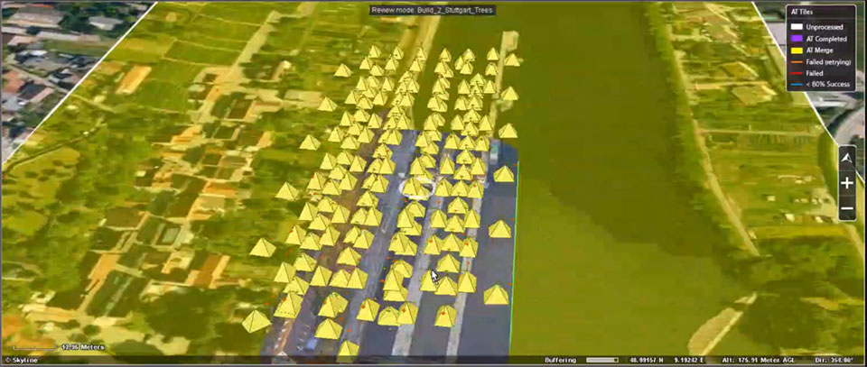
EagleView, a geospatial technology provider of software, aerial imagery and analytics, and Skyline Software Systems, a provider of 3D Earth visualization software, have partnered to enable customers to visualize their geospatial data in new ways. Through this new partnership, EagleView’s high-resolution ortho and oblique imagery can be converted into 3D Mesh layers with Skyline’s PhotoMesh and viewed, edited, and analyzed on Skyline’s TerraExplorer platform.
EagleView customers will be able to utilize Skyline’s TerraExplorer web-based GIS viewer and editor to see, analyze, and share their imagery in an immersive environment. Accurately measuring distance, area, and volume is now easier than ever, which is critical for planning and zoning to verify regulations or estimate the costs of flattening a site. With floodplain analysis, disaster management can identify flood risks before they happen, and with viewshed calculations E911 can pre-plan for high-profile events. Other key analytic features for customers will include the ability to analyze shade, view contour and slope maps, and view in underground mode. Beginning immediately, the additional 3D Mesh capability is now available as an add-on to any new Reveal Essentials+ Property or Neighborhood image capture.
Skyline offers a comprehensive platform of applications, tools, and services that enable the creation and dissemination of interactive, photo-realistic 3D environments. Its products are production proven in both the defense and commercial markets.
EagleView develops geospatial technology, providing software, imagery, and analytics. The company has the largest geospatial data and imagery library in history, covering 94 percent of the U.S. population. Its technology with more than 300 patents creates highly differentiated software, imagery, and analytics products for a diverse customer base.
Drone company PrecisionHawk has announced a partnership with EagleView, a provider of aerial imagery and data analytics for government, insurance and commercial sectors.
PrecisionHawk also announced that it has purchased both HAZON Inc. and InspecTools Inc., businesses that specialize in the delivery of inspection services and technology for the energy industry.
Both companies bring demonstrated expertise to enable tighter integration between the collection and the analysis of drone data, PrecisionHawk said. Paul Bingaman, CEO of InspecTools, and David Culler, CEO of HAZON, will join PrecisionHawk’s executive leadership team.
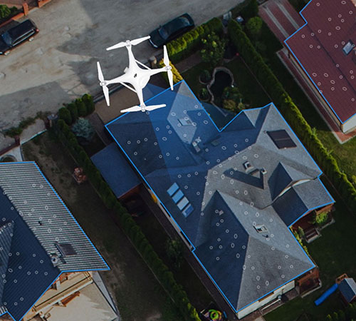
EagleView partnership for insurance claims
EagleView’s partnership with PrecisionHawk enables drone insurance inspections. (Photo: PrecisionHawk)
Through the partnership with PrecisionHawk, EagleView will collect at-scale insurance claims imagery via drones by leveraging PrecisionHawk’s global network of drone pilots, Droners.io.
The addition of PrecisionHawk’s drone pilot network will benefit EagleView OnSite Solutions for remote claims inspection. EagleView OnSite virtual desk adjustment combines imagery from multiple sources, including drones, with a variety of data analytics and reports to enable adjusters to efficiently triage claims, virtually inspect properties from their desk, and ultimately close property and casualty (P&C) claims faster.
“EagleView OnSite provides insurance customers with all the tools necessary to settle claims without ever going into the field,” said Rishi Daga, CEO of EagleView. “As drones transform the way the insurance industry operates, making inspections safer, easier and more cost effective, EagleView reinforces its commitment to drone technology to digitize manual workflows.”
Virtual drone inspections for insurance claims address a challenging trend in the P&C insurance industry. Over the past 20 years, the number of experienced insurance adjusters has dropped dramatically, causing labor shortages — especially after major storms hit. The demand for insurance adjusters is high, yet drone pilots add a new, untapped “labor force” to the equation.
Combining the EagleView OnSite virtual desk adjustment solution with PrecisionHawk will offer the insurance industry thousands of certified, trained drone pilots to perform high-quality insurance inspections at a competitive cost. With more than 25,000 claims processed by EagleView OnSite in the last 18 months, EagleView can help insurance carriers transform their property claim workflows and decrease cycle time by at least 40 percent to best serve their customers after a catastrophic natural disaster.
Drone technology and analytics for the energy market
HAZON brings extensive aviation experience, standards-based operating procedures, certified drone flight operations and inspection services, widely regarded as the best in the energy industry, to the PrecisionHawk team. The company has delivered more than 13,000 inspections totaling over 8,000 hours of flight time, with a majority focused in energy markets for Fortune 500 utilities.
InspecTools brings high-fidelity machine vision software and data analysis tools built for the renewable energy market. Their market-leading software for both solar-panel and wind-turbine inspection is utilized by some of the largest equipment manufacturers and service providers in the world. Customers like Vestas, PG&E and SMA Solar rely on InspecTools’ sophisticated reporting, analytics and machine learning capabilities.
“We’re very pleased to bring together the established technology and multi-market reputation of HAZON and InspecTools with PrecisionHawk’s experience, team and expanded portfolio,” said Michael Chasen, CEO of PrecisionHawk. “By combining these offerings, our customers will have access to extensive and leading-edge energy products and services, regulatory expertise and a record of safe, secure and compliant operations.”
Thanks to advances in technology and regulations, the energy market has quickly moved from experimenting with pilot projects to large scale deployment of drone solutions, PrecisionHawk said. Across distribution lines, transmission lines, solar panels, wind turbines, oil and gas and utility infrastructure, and emergency response, energy presents a current global market opportunity of $9.7 billion.
According to IDC, worldwide spending on robotics and drones will accelerate over the next four years reaching $201.3 billion in 2022. While the value is clear across time, safety improvements and operational efficiency, scaling and managing a drone program can be complex.
“HAZON is excited to bring our world-class best practices and reputation for standards-based operations and safety to the PrecisionHawk team,” said Culler. “By joining PrecisionHawk, our customers gain access to the next level of technological sophistication for more scalable, predictive and cost-efficient drone solutions that drive better business intelligence.”
“InspecTools brings years of experience, analytics tools and machine vision software for renewable energy that is an immediate value-add to PrecisionHawk’s software analytics platform,” Bingaman said. “This relationship further enhances the technologies and services that are fundamental to advancing the economic potential of drones in the energy market.”
The acquisition of HAZON and InspecTools underscores PrecisionHawk’s strategy to operate in high-growth markets and accelerate the adoption of commercial drones.
The acquisitions, which are subject to customary closing conditions, are expected to close later this month.
Australian geospatial startup Spookfish has won a major Asia Pacific industry award for exporting imaging technology to the North American market.
Spookfish has partnered with U.S.-based EagleView Technology Corporation, a North America provider of aerial imagery, and the two companies have collaborated to develop new technologies to meet the demands of the North American market.
In mid-2017, EagleView placed its first large order for multiple Spookfish platforms following an extensive flight-test program. Spookfish is now building the platform in significant volumes to meet EagleView’s demands.
Meanwhile, rollout of the Spookfish imaging technology for Australian customers is underway. Perth-based Spookfish offers high-resolution imagery of Perth, Melbourne and Adelaide online, with Sydney and Brisbane in the works.
Spookfish’s technology enables rapid imaging of vast areas in high resolution from a multitude of angles at a fraction of the cost of contemporary systems, the company claims. Spookfish aims to use these capabilities to make it easy for organizations of all sizes to gain access to premium imagery content and pervasive 3D models allowing concise, accurate and cost effective decision-making.
The Asia Pacific Spatial Excellence Awards (APSEA) showcase excellence within the spatial industry. Presented at Locate & GeoSmart Asia Conference in Adelaide, Australia, the APSEA award recognizes Spookfish’s success in innovating, commercializing and exporting its imagery capture and processing technology. Spookfish took home the APSEA Export Award after competition from companies around the Asia Pacific region.
“This is an exciting achievement for Spookfish and the beginning of a substantial export opportunity for Australia,” said Spookfish CEO Jason Waller. “The award is a testament to the entire Spookfish team and their ability to research, innovate and successfully bring new technology into operation.
“Spookfish has begun delivering multiple systems to our strategic partner, EagleView Technologies, with the export program generating significant revenue from capture systems and expected future royalty payments.
“More importantly, the partnership with EagleView delivers extensive benefits to our Australian customers because as our world-leading technology continues to develop, it immediately becomes available in the domestic market.”
Post-Irma hurricane damage is captured in aerial imagery by EagleView.
EagleView Technologies has captured post event aerial imagery of two million properties in the state of Florida following Hurricane Irma.
EagleView is a provider of aerial imagery and property data analytics for government agencies, insurance carriers and other private-sector organizations,
With an image library dating back to 2002 in the state of Florida, EagleView is able to provide emergency services, public safety agencies, property assessors and county GIS departments with ample imagery from before and after Hurricane Irma occurred. Combining high-resolution imagery and advanced machine learning capabilities, EagleView can identify the severity of property damage following a hurricane or other extreme weather event.
“Hurricane Irma inflicted severe damage on properties all over Florida and affected millions of people throughout the state,” said EagleView President Rishi Daga. “With a view of more than two million properties in Florida, we are assisting the agencies that use our imagery with their efforts, so they can continue to help all of those who have been affected.”
The two million properties have been photographed via specialized camera rigs in fixed-wing aircraft. The images are taken from an orthogonal (top-down) perspective as well as at oblique angles from all four cardinal directions. Oblique aerial imagery enables insurance claims adjusters to view all sides of a home’s exterior and gives emergency response crews greater insight into the storm’s effects in their communities.
“Our goal was to begin capturing and processing imagery as soon as possible to assist in recovery efforts, and we have done so at record speed,” said Jay Martin, Senior Vice President of Operations at EagleView. “Our next phase is to put boots on the ground and complete property inspections up close using drones as part of our EagleView OnSite solution.”
Post-hurricane image capture and processing will continue to take place throughout the upcoming weeks.
EagleView is completing the phase of image capture via fixed-wing aircraft and will soon move in to completing property inspections with the use of unmanned aerial systems (UAS), bringing post-event data directly to insurance claims adjusters.
As of Sept. 18, thousands of drone inspections have been scheduled through Friday, Sept. 22.
EagleView Technologies is actively flying to acquire post-storm imagery in Florida following Hurricane Irma. With more than 20 planes staged or in the air, EagleView is continuously capturing high-resolution aerial imagery to enable rapid assessment and response to Hurricane Irma relief efforts.
EagleView is a provider of aerial imagery and property analytics for the government, insurance and commercial sectors.
Using both fixed-wing aircraft and drones, EagleView imagery supports post-hurricane insurance claims adjusting, property assessment, public safety and land surveying professionals.
“With these hurricanes affecting so many Americans, we’re putting our planes in the air as soon as possible to begin the image capture process,” said EagleView President Rishi Daga. “From our unique high-resolution post-event imagery to our industry-leading machine learning capabilities, EagleView’s technology can massively accelerate recovery efforts and because of this, we find it crucial to take flight immediately once permitted into the airspace.”
EagleView’s historical image library, dating back to 2002 in Florida, offers insurance carriers, first responders, non-profit organizations and local government agencies the ability to analyze the impact of the storm on homes, commercial buildings and infrastructure by comparing previously captured imagery with the latest post-event images.
Image capture and processing post-Hurricane Irma will take place continuously over several weeks, with EagleView making constant updates to its nearly four-petabyte imagery and data library.
“We have access to an impressive amount of resources in Florida and the surrounding areas, allowing us to provide the largest post-storm image capture capabilities to our clients,” said Jay Martin, senior vice president of operations for EagleView. “Our team is working around the clock to deliver imagery to those who need it most following these devastating weather events.”
EagleView is capturing varying types of aerial imagery throughout Florida. This includes its ultra-high-resolution (UHR) imagery, also known as Reveal imagery, which is the highest resolution aerial imagery available on the market today.
EagleView, provider of aerial imagery and data analytics for government and commercial industries, has acquired OmniEarth, developer of machine learning technologies and decision-making tools for the water resource management, energy and insurance markets.
With the acquisition, EagleView gains OmniEarth’s machine learning capabilities, resulting in higher accuracy and precision of existing automated datasets.
OmniEarth’s ability to extract data from geospatial imagery will enhance EagleView’s property reports and Pictometry imagery classification of land areas such as impervious surfaces or irrigated farmland. It will also better identify roof shape and condition, tree overhang, decks, pools and other notable property features, EagleView said.
“We’re excited to welcome OmniEarth’s strong research-oriented management team, who will add to the innovative work that we’re doing at EagleView,” said EagleView President Rishi Daga. “This acquisition aligns perfectly with our mission of transforming industries by providing answers and saving time and money.”
Water authorities and government agencies rely on the water resource management tools from OmniEarth to determine budgeting and water cost savings for individual parcels as well as identify the overuse or abuse of water. Like EagleView, OmniEarth also supports the insurance underwriting market through its property feature identification capabilities.
“By gaining access to EagleView’s world-class Pictometry image library and product infrastructure, the OmniEarth team will be able to accelerate its development of advanced analytic solutions,” said Lars Dyrud, President and CEO of OmniEarth. “EagleView and OmniEarth have a shared goal of problem-solving and will be able to work together to achieve that vision.”
The acquisition gives EagleView opportunities to offer additional property data solutions for roof rating, virtual inspection, vegetation mapping, impervious surface mapping, solar suitability, and insurance prefill.
“OnmiEarth’s machine learning capabilities will create new opportunities for EagleView to use our imagery and property measurements to create a large prefill database,” said Frank Giuffrida, EagleView’s Executive Vice President of Engineering. “Additionally, marrying our high-resolution imagery and existing technologies with this machine learning system will help us accelerate our product development in existing markets as well as enter into new markets.”
EagleView is enthusiastic that the OmniEarth technologies will accelerate time-to-market on new product enhancements and greatly improve customer workflow capabilities. These innovations align with EagleView’s goals of capturing more frequent, higher-resolution imagery that covers more physical area and scaling through automation.
Pictometry International Corp. has secured an order from the Los Angeles Region – Imagery Acquisition Consortium (LARIAC) to provide digital terrain datasets through LiDAR capture of the 4,000+ square mile area that makes up Los Angeles County. Pictometry is a subsidiary of EagleView Technology, a provider of aerial imagery, data analytics and GIS solutions.
The LiDAR project will allow consortium members access to the digital data and imagery for use in 3D modeling, floodplain and watershed mapping, disaster management, land-use planning, transportation planning, volumetric studies, solar modeling, vegetation analysis, sustainability planning, and more.
Slated to begin later this year, the project will capture and deliver LiDAR in accordance with USGS Quality Level 2 specifications. At two points per square meter, this will equate to more than 21 billion individual measurements of elevation across the county.
Pictometry will also provide the consortium with a number of derivative digital terrain datasets, including a digital terrain model, digital elevation model, digital surface model as well as one and two foot contours of the project areas. “We are looking forward to the LiDAR capture which will be the final phase of the LARIAC4 imagery and mapping project,” said Mark Greninger, geographic information officer, County of Los Angeles. “The digital datasets when combined with Pictometry aerial imagery and our geographic data will provide powerful intelligence and information for all the members of LARIAC.”
“The elevation data will provide the county and consortium members a core of authoritative, high quality data that will be critical for mapping, analysis and support of the county’s mission,” explained Greninger. “These datasets will be included in our enterprise GIS system, available both internally and externally to allow for more cost-efficient operations.”
Robert Locke, Pictometry president of Government Solutions, said that the project represents a natural progression in the long-term business relationship that the company has with the consortium. “We are pleased that the County of Los Angeles recognizes Pictometry’s expertise and ability to provide LiDAR and digital models,” Locke said. “While known as the leader in aerial image capture, Pictometry is also extremely qualified and experienced in LiDAR capture and delivery.”
Pictometry completed most of the LARIAC4 mapping and image acquisition project during 2014, with the remainder to be completed in 2015.