Tag: Earth Observation Satellite

  • Orbital Insight partners with Satellogic on satellite imagery and video

    Orbital Insight partners with Satellogic on satellite imagery and video

    A sample image from Orbital Insights showing classes of military aircraft at a base. (Image: Orbital Insights)
    A sample image from Orbital Insights showing classes of military aircraft at a base. (Image: Orbital Insights)

    Orbital Insight will integrate Satellogic’s high-resolution multispectral imagery, hyperspectral imagery, and full-motion video into its GEOINT platform

    Geospatial intelligence company Orbital Insight has partnered with Satellogic, a leader in sub-meter resolution satellite imagery collection. The partnership will integrate Satellogic’s high-frequency, high-resolution collections of satellite imagery and full-motion video into Orbital Insight’s platform and offer customers better access to high-quality data, improve the revisit rate, and reduce the cost of running analytics.

    Satellogic designs, manufactures and operates its own constellation of Earth observation satellites. It  has 22 operational satellites in low Earth orbit with plans to launch up to 12 additional satellites by the end of the year. The company aims to expand its constellation to more than 200 satellites by 2025 for daily global coverage of the entire surface of the Earth.

    Orbital Insight’s flagship GO platform combines information from the world’s sensors to analyze economic, societal and environmental trends at scale and support activity-based intelligence. Commercial businesses and government agencies use the self-service platform to synthesize answers to critical questions about what’s happening on and to Earth.

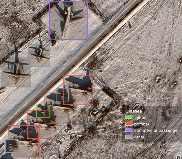
    Satellogic will provide high-resolution Earth observation data at vastly superior unit economics. This will allow Orbital Insight customers to increase the number of daily revisits on points of interest, see a more granular picture and get deep insights that were not possible before.

    “Advanced geospatial analytics require access to high-resolution, high-frequency satellite imagery and simple tasking,” said Kevin O’Brien, CEO, Orbital Insight. “Satellogic is disrupting the industry with a cost-effective, vertically integrated business model. This approach aligns well with our philosophy of making geospatial intelligence efficient, intuitive, and simple so that our customers can get timely insights, make critical decisions, and respond faster.”

    “Our mission is to enable greater access to critical Earth observation data. Working with Orbital Insight extends our reach, making our data available to more customers across diverse fields who need to know how the world around them is changing,” said Emiliano Kargieman, CEO and co-founder of Satellogic.

  • South Korean satellite uses navigation receiver from RUAG Space

    South Korean satellite uses navigation receiver from RUAG Space

    Photo: RUAG Space
    Photo: RUAG Space

    On March 20, a South Korean Earth Observation satellite will be sent to space, carrying a navigation receiver from RUAG Space to determine the satellite’s position in orbit. The Earth Observation satellite is being launched by the Korea Aerospace Research Institute (KARI), South Korea’s space agency.

    The precision single-frequency low Earth orbit GNSS receiver, called LEORIX, is a GPS + Galileo receiver from RUAG Space’s new generation of receivers.

    More than 80 RUAG Space receivers of the latest generation (LEORIX for Low Earth Orbit, GEORIX Geostationary Orbit and PODRIX) have been ordered by customers in Asia, Europe, Middle East and the United States. They will be launched for various low and geostationary Earth Orbit missions within the next few months and years.

    Currently, 22 navigation receivers from RUAG Space are in orbit. The satellite CAS-500-1 will be launched aboard a Russian Soyuz-2 launch vehicle from the spaceport in Baikonur, Kazakhstan.

    After the launch of CAS-500-1, South Korea plans to send the CAS500-2 satellite to space. A launch date of this second mission is not yet defined. The CAS500-2 mission also will fly with a LEORIX receiver from RUAG Space. The satellite builder — Korea Aerospace Industries (KAI) — already has received the space-borne navigation receiver.

    PODRIX in Space

    Since November 2020, two new Precise Orbit Determination Receivers (PODRIX) from RUAG Space have been in orbit. They determine the position of ocean-monitoring satellite Sentinel-6.

    The PODRIX GNSS spaceborne receiver achieves a very high, real-time in-orbit accuracy of the satellite’s position in orbit from below one meter to a few centimeters using on-ground post-processing. The high accuracy is achieved through simultaneously processing of multi-frequency signals from GPS and Galileo.

    PODRIX GNSS spaceborne receivers are built on the experience of the more than 20 GPS-only receivers of the RUAG Space legacy receiver generation now in orbit.

    The receivers precisely determine the position of a satellite once in orbit, which improves the satellite’s performance. Sentinel-6 measures the sea level on a global scale with unprecedented accuracy, which is crucial for climate change research. Every millimeter or centimeter in further precision highly improves the performance of the mission. The more precise the Sentinel-6 spaceborne GNSS receiver from RUAG Space works, the more precise are the data of this climate mission.

    RUAG Space is a supplier to the space industry in Europe, and has a growing presence in the United States. It develops and manufactures products for satellites and launch vehicles, playing a key role both in the institutional and commercial space market. RUAG Space is part of RUAG International, a Swiss technology group focusing on the aerospace industry.

  • GMV leads development of ESA COVID-19 Space Hunting Platform

    GMV leads development of ESA COVID-19 Space Hunting Platform

    GMV will search using artificial intelligence for any correlations between COVID-19 spread and environmental parameters.

    Image: ESA
    Image: ESA

    The European Space Agency (ESA) has launched an internal initiative to cull ideas for supporting its member states in the study and analysis of the COVID-19 pandemic. Under this initiative, an idea from the Galileo Navigation Science Office has been selected.

    The COVID-19 Space Hunting Platform is designed to facilitate access to and processing of existing COVID-19 databases for epidemiological studies, topping them up with data from ESA’s Earth observation satellites.

    The project will use artificial intelligence to look for correlations between COVID-19 spread and environmental parameters, such as humidity and temperature.

    The aim is to help researchers generate products and statistics that might be useful for decision-making purposes in terms of protection measures and lockdown, while also vetting the efficiency of the measures taken.

    Development of the COVID-19 Space Hunting Platform will be primed by the technology multinational GMV. The Universidad Politécnica de Valencia will also be taking part, with support for processing, data analysis and interaction with diverse epidemiological research groups. The university has defined a mathematical COVID-19 transmission model and has been publishing periodical updates and forecasts of its trend in Spain.

    In the medium term, the COVID-19 Space Hunting Platform could help in setting up a collaborative COVID-19 website for scientists to analyze existing data more efficiently, benefiting also from ESA’s data-processing software packages.

    The GSSC team will lead the program. (Photo: ESA)
    The GSSC team will lead the program. (Photo: ESA)

    The project will be carried out around the GNSS Science Support Centre (GSSC) platform, which hosts and indexes COVID-19 data. The three-month process will analyze public COVID-19 data and make this information available to the science community. This will lead to a first version with basic pandemic-propagation algorithms, updated thereafter to ensure the information is always precise and up to date.

  • Esri releases Sentinel-2 Image Services through Living Atlas

    Esri is releasing Sentinel-2 Image Services to all Esri users for no additional cost.

    According to the company, Sentinel-2 is an Earth Observation Satellite that provides multi-spectral imagery for any location in the world at 10-meter resolution. Currently in beta, the service is updated daily with new imagery for all ground locations every five to seven days.

    The Sentinel-2 Image Services provide temporal, multi-spectral imagery of the entire globe for improved monitoring of agricultural and forest conditions, monitoring of land cover changes, and to assist with natural disaster management.

    Sentinel-2 is part of Copernicus, the world’s largest single Earth observation program directed by the European Commission in partnership with the European Space Agency.

    Esri makes the multi-spectral data quickly accessible using ArcGIS Image Server and publishes an image service through the ArcGIS Living Atlas of the World, hosted on the Amazon Web Services Infrastructure.

    The service includes all Sentinel-2 imagery going back 14 months, enabling change to be easily reviewed. Image analysis can be run directly on the service to create indexes displaying properties such as vegetation health or soil moisture as well as quantifying the changes over time, for better understanding of the environment.

    “We are committed to helping our users discover, explore, and better understand our changing planet,” said Jack Dangermond, Esri founder and president. “Pairing Sentinel-2 imagery with our ArcGIS Image Server provides a powerful platform for in-depth analysis which can inform meaningful action.”

    Sentinel-2 multi-spectral imagery can provide better visualization and understanding of catastrophic events such as Hawaii’s Kilauea volcano, the company said. The ability to use imagery of the volcano along with other spatial data, such as digital elevation models, provides an unprecedented opportunity to help predict lava flow direction and provide advanced notice to those who may be in danger.

    Sentinel-2 can also help provide understanding of the conditions that lead to fires such as this past winter’s Thomas Fire, which is California’s largest wildfire on record. The Thomas Fire burned more than 280,000 acres and triggered massive mudslides. Visualizing factors, such as periods of increased moisture contributing to more lush vegetation followed by hot and dry weather, can help predict future wildfires and mitigate their effects in the future.

    The Sentinel-2 imagery is available through the Living Atlas, the foremost collection of geographic information from around the globe. The Living Atlas is included with all ArcGIS online subscriptions. It is comprised of maps, apps, and data layers that support the work of thousands of Esri users around the world. Full service access, including a rolling 14-month archive of the Sentinel-2 data, is now available to all Esri ArcGIS users.