Tag: Effigis

  • Industry experts share GNSS trends in the ag industry

    Industry experts share GNSS trends in the ag industry

    Industry experts share how GNSS can be used for precision agriculture.


    Headshot: Vazquez
    Vazquez

    EUROPEAN SATELLITE SERVICES PROVIDER (ESSP)
    Juan Vazquez
    Team Leader, EDAS Service Provision

    Pass-to-pass accuracy is the key performance indicator to assess the precision of guidance systems, characterizing the short-term dynamic performance determined from off-track errors along the straight segment passes (error with respect to the desired path in the direction perpendicular to the tractor trajectory).

    The results of the tests reported in this article, jointly performed by Topcon Agriculture and ESSP, confirm that EDAS DGPS corrections can support a wide range of precision agriculture applications and represent a real alternative for cereal farms, when located in the vicinity (at least up to 260 km away) of an EGNOS reference station, complementing the benefits that the EGNOS signal-in-space is already providing to a large number of agriculture users in Europe.

    More info on EDAS is available at [email protected].


    Headshot: Keable-Vézina
    Keable-Vézina

    EFFIGIS GEO-SOLUTIONS
    Nicos Keable-Vézina
    Director of Precision Agriculture

    Thanks to artificial intelligence, variable-rate application of nitrogen has made great strides in recent years. Science has demonstrated that effective nitrogen management requires an array of technologies, including massive databases. Data is geospatial (positioning signal and satellite imagery enabling the identification of changes in nitrogen requirements), agronomic (mainly soil texture and seasonal weather), and economic (grain and nitrogen price).

    To automate extraction and analysis of such data, combining very low-cost positioning technologies, satellite imagery and artificial intelligence is paramount. A democratized access to technology has led to the development of scientifically proven nitrogen prescribing platforms, among them FieldApex, that calculate the most profitable nitrogen rates and generate prescriptions in seconds without soil sampling. Further technological and platform integrations are likely to bolster such innovation.


    Headshot: Rioja
    Rioja

    TOPCON AGRICULTURE
    Julian Rioja
    Channel Development and Business Intelligence Manager

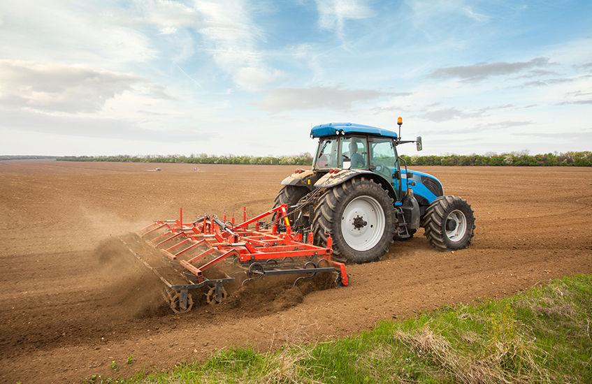
    All tests were performed using Topcon receivers, vehicles and auto-steering systems. Two different Topcon guidance systems on board tractors ran simultaneously to assess the EDAS DGPS positioning performance with respect to the reference provided by a real-time kinematic (RTK) system. Hence, two independent positioning outputs were continuously available (the receivers were placed along the same longitudinal axis on the roof of the tractor):

    • RTK position: provided by the AGI-4 receiver fed by Topcon’s Hiper V RTK base.
    • DGPS position: provided by the AGI-4 receiver fed by the EDAS Ntrip service.

    On board the tractor, two Topcon X35 consoles were each connected to one of the receivers. A Topcon AES-25 electric steering system was installed on the tractor so that the selected navigation input (RTK or EDAS DGPS) could be used to automatically guide the tractor along the defined reference pattern.


    Headshot: McClure
    McClure

    HEMISPHERE GNSS
    John McClure
    Engineering Manager, Precision Agriculture

    Precision agriculture is expanding the use of ISOBUS for CAN communication between a common terminal and implements, to reduce clutter in the cab. These virtual terminals now act as display and user entry for multiple applications including GNSS receivers and factory or after-market steering systems.

    INS-aided GNSS solutions, typically using RTK or satellite-based correctors such as Atlas, provide time/position data for rate and section control and auto-steering. CAN-based NMEA 2000 is the commonly used receiver protocol for position data, replacing serial NMEA 0183.
    All major tractor, agricultural equipment, and GNSS manufacturers attend regular “Plugfest” meetings, organized by the Agriculture Industry Electronics Foundation, to test interoperability of products and set common standards.

    Smart CAN dongles are being developed to read sensors and control systems, supplying positioned data via telematics as the Big Data for real-time and post analysis.


    More: Precision agriculture aided by internet, SBAS

  • Agriculture moving to customized nitrogen fertilization

    Agriculture moving to customized nitrogen fertilization

    Photo courtesy of Effigis.
    Photo courtesy of Effigis.

    By Yacine Bouroubi
    Effigis Chief Scientist, Earth Observation Division

    Canadian agriculture has an international reputation for being highly productive and modern. It plays a major role in the country’s economy, and contributes to 8 percent of GDP and 12 percent of jobs.

    Everyone involved in Canada’s agricultural sector is aware of the environmental issues associated with farming. To optimize performance and revenue while respecting the environment, for the past few years producers have been counting on a new ally: precision agriculture.

    Using technologies such as GPS, auto-guidance, variable rate technology, yield sensors, satellite images and drones, precision agriculture is now part of the day-to-day life of farmers. The application of agricultural inputs based on the four Rs (the right source at the right rate, in the right place at the right time) must be based on scientific knowledge and technical know-how. Such knowledge and know-how are based on reliable, accurate and complete information, which is often necessary on a global scale, but with a rather fine spatial resolution. Satellite images are the ideal tool to provide much of the information required.

    The SCAN program
    The SCAN program extracts agronomic knowledge related to nitrogen fertilization to make more accurate models. (Image: Effigis)

    Using Satellite Images. For about 15 years now, sensors on very high spatial resolution (VHR) Earth observation (EO) satellites have been offering a source of data that can provide information on soils and crops at adequate spatial scales (around 2 meters using multispectral imagery) with an unbeatable price/quality ratio. Products derived from satellite images for estimating the quantity of nitrogen fertilization to meet plants’ nutritional requirements are a concrete example of an operational use of this data.

    Determining the optimal dose of nitrogen is not easy, since it depends on complex interactions between plants, the soil, weather conditions and management practices. By wanting to avoid performance loss due to nitrogen deficiencies, current practices favor overfertilization, which leads to unnecessary costs as well as serious environmental problems.

    Agriculture and Agri-Food Canada developed a model based on statistical analyses for understanding the direct relationship between the properties that influence nitrogen requirements (soil, growth, weather and management) and the response to nitrogen fertilization, based on a large number of fertilization trials. These relationships were implemented in a system called SCAN (Soil, Crops and Atmosphere for Nitrogen). Satellite imagery acquired at a specific growth stage provides information required for the operation of SCAN.

    SCAN includes two major innovations: extracting agronomic knowledge related to nitrogen fertilization and modeling this knowledge in the form of inference rules in a fuzzy logic system. Work is ongoing to advance these two aspects of SCAN and validate it for various agricultural regions, as well as adapt it to various types of crops.

    A SCAN web platform will be tested by 100 users starting in the summer of 2016, in anticipation of its commercial use in 2017.

    To read Yacine Bouroubi’s full blog, go to www.effigis.com/blog.

  • Juniper to Exhibit Sub-Meter GPS Solution at Esri User Conference

    Juniper to Exhibit Sub-Meter GPS Solution at Esri User Conference

    Photo: Juniper Systems 

    Juniper Systems is exhibiting its sub-meter GPS solution using Esri ArcPad, Effigis’ EZSurv Post-Processing software, and its ultra-rugged handheld computers — a combination the company says is budget-friendly and easy-to-use — at the Esri User Conference, being held in San Diego July 20–24.

    The sub-meter solution involves collecting GIS data using a Juniper Systems rugged handheld running ArcPad data collection software, and then using Effigis’ EZSurv software to post-process the data, resulting in sub-meter GPS accuracy. Users can import and export data, including custom attributes, from their GIS. The data collection process bypasses the need for expensive survey-grade GPS receivers, providing both an affordable and simple solution for professionals who require sub-meter accuracy, Juniper Systems said.

    “This solution is a great option for people looking for sub-meter accuracy without the steep price,” said Trevor Brown, Natural Resources market manager at Juniper Systems. “The range of applications that can benefit from this type of solution is very broad, with uses in forestry, agriculture, environmental monitoring, and asset management, to name a few. And not only is it inexpensive, it’s also super simple. You can have sub-meter accuracy with the click of a button.”

    Those attending the Esri User Conference can see this affordable sub-meter solution at Juniper Systems’ booth #2212. The data sheet can be downloaded,  or visit Juniper Systems’ website to learn more.

  • Juniper Systems, Effigis Provide Sub-Meter GPS Accuracy

    Juniper Systems, Effigis Provide Sub-Meter GPS Accuracy

    The Juniper Archer 2. Photo: Juniper Systems
    The Juniper Archer 2. Photo: Juniper Systems

    Rugged handheld manufacturer Juniper Systems and Effigis, a geomatics solutions provider, have partnered to provide a powerful solution to capture and post-process GPS data to attain sub-meter accuracy.

    Effigis’ OnPOZ Precision Positioning Software suite takes advantage of the superior GNSS performance of Juniper Systems’ Archer 2 rugged handheld to collect high-accuracy GPS data. First, EZTag CE software is used on the Archer 2 to capture GPS field data points. The data is then sent to a desktop computer, where EZSurv Post-Processing Software automatically post-processes the data to achieve results with sub-meter accuracy. EZSurv removes the hassle of post-processing, requiring the click of a button to run, the companies said.

    Juniper Systems’ Archer 2 is ruggedized, enabling it to perform well as a data-collection tool in any environment, while the enhanced GNSS receiver provides a reliable signal, even in heavy tree canopy.

    “Achieving sub-meter GPS accuracy typically has two barriers in people’s minds. One, the hardware and software are usually expensive. And two, the thought of post-processing makes a lot of people cringe. The OnPOZ suite, on the other hand, is powerful, yet comes at a price people are comfortable with, and it takes care of all the post-processing for you,” said Jim Benson, Utilities & Public Services Market Manager at Juniper Systems. “The Archer 2 handheld really finishes off the whole package. Its GNSS receiver is outstanding, performing reliably even under trees, and the handheld is so well designed, you can count on it to work well in any environment.”

    To learn more about the Archer 2 and OnPOZ Precision Positioning Software suite, download the brochure.

  • Effigis Offers New Version of EZSurv Post-Processing Software

    Effigis today announced the worldwide availability of a new version of its OnPOZ EZSurv GNSS post-processing software (V2.92). Improvements include automatic access to data from more than 8,000 base stations around the world and availability of more than 750 mapping systems, as well as enhanced compatibility with 22 native GNSS formats.

    EZSurv, Effigis’ GNSS post-processing software, provides a reliable, efficient RTK offline solution to improve survey or GIS data accuracy, the company said. EZSurv is fully compatible with most industry-standard field survey and GIS data collection software.

    The latest version of EZSurv offers easy, automatic access to base station providers worldwide: data from more than 8,000 stations around the world can be automatically accessed directly through the EZSurv interface, without any extra user intervention, the company said.

    Effigis constantly works on bringing data from more base stations to EZSurv users to improve worldwide connectivity to regional reference frames. “We regularly implement compatibility with additional base station providers as we get the necessary technical information,” said Denis Parrot, president of Effigis. Once compatibility is established, all necessary information to access new base stations is automatically updated through the Internet, without any software release or update.

    This latest release also integrates compatibility with new GNSS binary formats, which brings EZSurv compatibility to 22 native formats.

    Finally, EZSurv now offers more than 750 predefined “Map Projections/Datums” to help users quickly translate GNSS positions into regional mapping systems. This predefined map projection set is continuously updated on users’ desktops by a simple Internet download.

    “EZSurv V2.92 brings GNSS post-processing to an unprecedented level of ease of use,” added Denis Parrot. “EZSurv is a real gateway to many GNSS networks worldwide and provides post-processed results in the proper reference frames. Our commitment to streamline GNSS post-processing makes EZSurv the ideal tool to complement RTK systems.”

  • Magellan eXplorist GIS Pro 10 GPS Now Offers Effigis OnPOZ Data Collection and Post-Processing Software

    Magellan and Effigis announced a partnership and reseller agreement to create a comprehensive out-of-the-box solution for Magellan customers to collect and post-process geo-localized data using Effigis OnPOZ software on the Magellan eXplorist GIS Pro 10.


    According to the announcement, as part of the partnership, three Effigis OnPOZ precision positioning software products are available for the Magellan eXplorist GIS Pro 10, a rugged, lightweight and waterproof handheld GPS device specifically designed for professional GPS/GIS data collection.   

    • EZTag CE, geospatial data acquisition software, facilitates the collection of geospatial data including points, lines and polygons plus their specific attributes, and valuable GNSS observations necessary for post-processing.  Users can customize the data capture properties to match their office database structure. 
    • GNSS Driver for ArcPad, software extension that improves the quality of data collected using ESRI ArcPad GIS software.
    • EZSurv, GNSS post-processing software, provides a reliable, efficient RTK offline solution for data integrity. Users can play back their RTK survey for QA control, make corrections to non-RTK GNSS field data, or significantly improve GIS data accuracy.  

    “The combination of Effigis OnPOZ software and the Magellan eXplorist GIS Pro 10 device creates a powerful and accurate, yet cost-effective solution for collecting and post-processing GIS data,” said Stig Pedersen, Associate Vice President of Product Management for Magellan. “Our partnership with Effigis enables Magellan to continue providing GIS professionals with complete GIS data collection solutions to facilitate their biggest GIS mobile application challenges.”   

    Magellan reports that with its rugged IPX-7 waterproof casing, the eXplorist GIS Pro 10 device is designed for GIS professionals who need to collect GPS/GIS data. The GPS device can deliver 3 to 5 meters accuracy in real-time using its internal GPS receiver and works with supported Bluetooth-enabled GPS receivers to achieve 1 to 3 meter accuracy. Powered by Windows Mobile v6.5 OS, the Pro 10 GPS device allows GIS professionals to run powerful GIS data collection software, such as Effigis, and a wide range of Windows Mobile data collection applications.

    “Partnering with a leading GPS manufacturer like Magellan will allow Effigis to reach a wider range of GNSS users,” said Denis Parrot, President of Effigis. “With this agreement, we are very pleased to continue to bring an enhanced level of data accuracy and reliability to users.”

    Effigis OnPOZ software for the Magellan eXplorist GIS Pro 10 is available now from Magellan’s authorized GIS resellers as a bundled option with the GPS device, or as a software-only add-on for users who previously purchased the Pro 10 model. More details are available at www.MagellanGPS.com/GIS.