Europe’s regional satellite-based augmentation system (SBAS), EGNOS, has received upgrades to advance the reliability of GNSS positioning information, according to EUSPA.
Historically, EGNOS has provided safe, uninterrupted satellite navigation services to aviators, and some maritime, railroad, and land-based users in Europe. This system upgrade includes extending its service area, adding advanced functionalities, and reinforcing dual-frequency and multi-constellation services.
The EGNOS V242B system upgrade will expand services outside of its service area and enhance availability to users. Additionally, the upgrade ensures aviator access to lifesaving services such as Localizer Performance with Vertical Guidance (LPV)-200. The upgrade also includes more advanced data processing functions to cater to increased issues with peak solar activity and ionospheric phenomena that interfere with EGNOS signals and services.
Dual-frequency and multi-constellation services were also improved in the EGNOS upgrade. The improvements revamped EGNOS Version 2, and reinforced EGNOS services before launching EGNOS Version 3 (V3).
EGNOS delivers two frequencies and has amplified Galileo signals, hence creating a multi-constellation capability. When EGNOS V3 is launched, it will offer additional services and enhance protection against cyberattacks, further advancing EGNOS’ safety-critical applications across Europe.
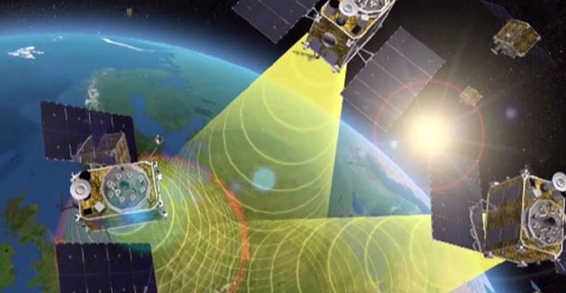
Europe’s EGNOS satnav system has been providing safety-of-life services for 10 years. EGNOS, the European Geostationary Navigation Overlay Service, transmits signals from a duo of satellite transponders in geostationary orbit.
The satellite-based augmentation system (SBAS) gives additional precision to U.S. GPS signals, delivering an average precision of 1.5 meters over European territory, as much as a 10-fold improvement over unaugmented signals. EGNOS also provides confirmation of GPS signal integrity through additional messaging identifying any residual errors.
While the EGNOS Open Service has been in general operation since 2009, EGNOS began its safety-of-life service in March 2011.
The European Space Agency (ESA) designed EGNOS as the European equivalent of the U.S. Wide Area Augmentation System (WAAS), working closely with the European air traffic management agency Eurocontrol. ESA then passed EGNOS to the European GNSS Agency (GSA) to run operationally.
Guiding airliners
EGNOS’s primary customer is aircraft. Without guidance from the ground, pilots using EGNOS can confidently descend in bad weather to 60 meters’ altitude before needing to make visual contact with the tarmac.
On March 17, 2011, France’s Pau Pyrénées Airport was the first airport to use EGNOS. Today, more than 385 airports and helipads and 60 airlines across Europe use EGNOS-based LPV-200 approaches (short for Localizer Performance with Vertical guidance – 200 feet). The EGNOS service requires no ground equipment, and replaces the radio guidance beamed upward by traditional CAT I instrument landing system (ILS) infrastructure with no decrease in performance.
As of March 2021, more than 385 airports and helipads and 60 airlines across Europe are using EGNOS-based LPV-200 approaches. (Image: ESA)
Serving drones
EGNOS is now being eyed as the enabler of unmanned aerial vehicles (UAVs). The GSA has supported numerous trials of drones equipped with EGNOS as well as Galileo through its EGNSS4RPAS project. Crewed aircraft are expected to be vastly outnumbered in our skies by all kinds of UAVs, employed for everything from weather and environmental monitoring to personalized delivery services.
U-Space is Europe’s program to integrate drones into the airspace. (Image: ESA)
The traditional person-based air traffic control model will need to evolve to accommodate such a shift, based on automated monitoring, traffic management and collision avoidance. In Europe, this highly automated version of air traffic control is termed U-space.
EGNOS’s safety-of-life service is essential to making this happen, moving from today’s situation — where drones are limited to specific air corridors and line-of-sight operations — to let them roam freely but safely in busy airspace and built-up areas.
“The whole idea behind EGNOS’s safety-of-life has been to render satellite navigation sufficiently reliable for any kind of use,” explained Didier Flament, who leads ESA’s EGNOS team. “After 10 years of faultless operations, new applications are becoming plain. Drone flight is one example. EGNOS is also being evaluated for train positioning as well as assisted and autonomous automobile driving.”
EGNOS, the next generation
ESA retains responsibility for the system’s evolution, and the middle of this decade should see the debut of its new generation, EGNOS v3.
“While the current system only works with single-frequency GPS signals, EGNOS v3 will operate on a multi-frequency, multi-constellation basis, able to augment all available satellite signals in both L1 and L5 bands, including Galileo,” Didier said. “The result will be far enhanced performance and reliability.
“In addition, we are working with developers of other SBAS around the globe to ensure they stay fully interoperable so for instance EGNOS-equipped aircraft can fly between continents on a seamless basis. Such interoperability, combined with the arrival of the other SBAS systems under development in other regions, will lead to a quasi-global worldwide safety-of-life service coverage in the year 2030.”
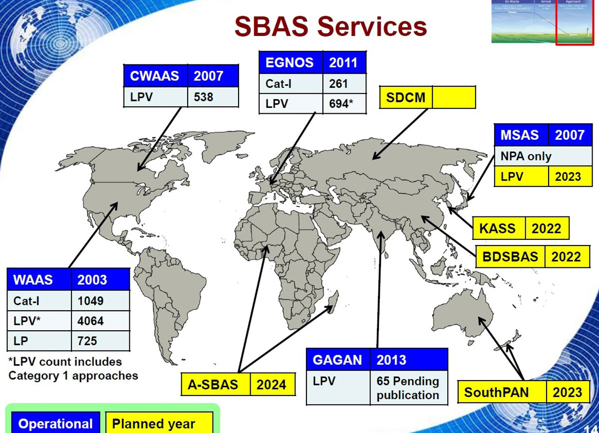
Operational and planned satellite-based augmentation systems (SBAS) around the globe. (Image: ESA)
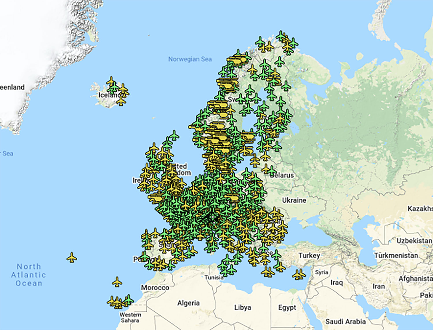
If you’ve taken a flight in Europe recently, then the chances are growing that you’ve been a pioneer EGNOS user. Satellites in orbit would have guided your airliner’s descent, rather than signals beamed from the ground. You wouldn’t have felt any difference — except for possibly a smoother ride.
Cockpit of a new EGNOS-equipped Airbus 350 XWB, on show during the inaugural EGNOS Day at Toulouse-Blagnac Airport on May 7, 2015. (Photo: ESA)
More than 180 European airports have now been certified to make use of the ESA-designed European Geostationary Navigation Overlay Service — EGNOS — for approaches to given runways. This includes approaches at major hubs such as Paris Charles de Gaulle, Frankfurt and Amsterdam Schiphol. Thanks to EGNOS, safe landings would still be possible even if an airport were shut down entirely.
Sharpening the precision of GPS satnav signals over most European territory, EGNOS was designed to make satnav reliable enough for safety-critical aviation employment, but has found a wide range of other uses, from agriculture to road, rail and maritime transport.
An EGNOS app is available from the Apple and Google Play stores, offering easy access to all EGNOS-related information, including the different EGNOS services, official documentation, historical and current performance data, support material and contact with the 24/7 EGNOS helpdesk.
An EGNOS V3 Ranging and Integrity Monitoring Station (RAIMS) being tested at the Santiago de Compostella site in Spain, designed and manufactured by Thales Alenia Space in Italy. (Photo: ESA)
EGNOS is based on a network of monitoring stations across Europe that perform independent measurements of GPS signals, so that corrections can be calculated to boost satnav positioning performance. These results are passed to users immediately via a trio of geostationary satellites.
The service is allowed just a one in 10 million chance of error. If this tolerance is exceeded, EGNOS users are informed within six seconds. The result is that EGNOS-augmented signals meet the extremely high performance standards set out by the International Civil Aviation Authority, adapted for Europe by Eurocontrol, the European Organisation for the Safety of Air Navigation.
EGNOS operations are the responsibility of the European Global Navigation Satellite System Agency (GSA) of the European Commission and run by the ESSP, European Satellite Services Provider.
EGNOS is the European equivalent of the U.S. Wide Area Augmentation System (WAAS), which was the world’s first satellite-based augmentation system. The U.S. and European systems have been carefully designed to work together seamlessly.
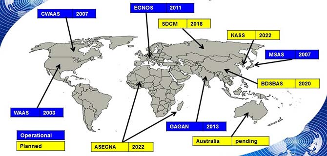
Additional equivalent regional systems, fully interoperable with the existing ones are either in operation (Japan, India, Canada) or in definition or development (Russia, China, South Korea, West Africa and Australia).
Satellite-based augmentation systems worldwide. (Image: ESA)
Through the LPV-200 procedure, short for “localizer performance with vertical guidance 200 feet,” signals from space guide pilots through any weather down to within just 60 meters (200 feet) of the runway, at which point they make visual contact with the ground for a final go/no go landing decision.
EGNOS offers all-weather access to all certified runway approaches — each side of a runway requiring its own, separate, certification — without the need for expensive ground Instrument Landing System infrastructure. Satellite-based landing approaches can also be tailored to be smoother and more fuel-efficient.
Smaller airports unable to afford ground instrumentation draw the greatest benefit. Employing EGNOS means they get to operate in all weather conditions.
ESA retains the lead role in the future development of EGNOS, working with Thales Alenia Space and Airbus Defence and Space and their subcontractors to design, develop, deploy, and validate and test the new design elements.
While the current system is solely reliant on GPS, the next-generation EGNOS V3 will combine the use of GPS with Europe’s own Galileo satnav system to boost EGNOS accuracy and reliability still further. It is planned to enter service around 2025.
The European GNSS Agency (GSA) has officially launched the equipment for dual frequency Galileo, GPS and EGNOS project (EDG²E) with a consortium led by Thales. The four-year project intends to develop a dual-frequency multi-constellation receiver, enabling enhanced navigation capabilities, support standardization and certification preparation, and facilitate the expected increase in air traffic, both in Europe and globally.
The prototype EDG²E receiver use GPS and Galileo signals as well as those from the European SBAS multi-constellation EGNOS. The project aims to achieve a prototype demonstration by 2021. At the end of the EDG²E project, the first SBAS dual-frequency GPS+Galileo receivers for aviation will be ready for final development and use in the aviation sector and in other safety-critical applications. Fully achieved receivers are foreseen to be installed in commercial aircraft by 2025.
EGNOS, certified for use in aviation since February 2011, is developing its own next generation, called EGNOS V3, to further enhance performance by complementing both the EU Galileo and the US GPS satellite navigation constellations.
“EGNOS v3 will provide aviation users with an increased quality of services, better accuracy and extended coverage area among other key performance indicators” said Jean-Marc Pieplu, GSA head of the EGNOS Services Programme. “Fundamental Element Programme is a medium that supports development of terminals and antennae fostering use of E-GNSS in all domains. In this perspective,EDG²E is an important step for GSA as it will contribute to availability of high technology products on the aviation market, taking benefit of Dual Frequency Multi Constellation feature offered by EGNOS v3.”
The consortium includes Thales, Thales Alenia Space and ATR, as well as contributions from Dassault Aviation and the French Civil Aviation Authority.
Feature image courtesy of the European Space Agency (ESA).
The next generation of Europe’s satellite navigation overlay service, EGNOS, will combine use of GPS and Galileo signals to improve accuracy and robustness of navigation for air traffic and other uses where lives are at stake.
A contract was signed Jan. 26 at ESA’s technical centre in the Netherlands for the second generation of the European Geostationary Navigation Overlay Service, EGNOS V3, planned to enter service in 2025.
ESA Director of Navigation Paul Verhoef signs the EGNOS V3 contract Jan. 26 with Senior Vice President of Airbus Defence and Space, Mathilde Royer Germain. (Photo: ESA)
ESA Director of Navigation Paul Verhoef signed the contract with the senior vice president of Airbus Defence and Space, Mathilde Royer Germain, in the presence of senior managers of the European Global Navigation Satellite System Agency (GSA) and of the European Commission.
This improved version of the service will take advantage of in-operation Galileo signals as well as new frequencies from an improved class of GPS satellites. Use of the L5 second frequency will improve service robustness against errors and propagation delays caused by the ionosphere, an electrically active outer layer of Earth’s atmosphere.
“This will be the first such regional satellite augmentation systems worldwide to employ dual frequency, GPS and Galileo signals,” comments Didier Flament, overseeing EGNOS development for ESA.
For aircraft with the latest avionics, EGNOS V3 will be able to guide them accurately and safely down to Category 1, a 10 m Vertical Alert Limit (also called Cat1 Autoland capability), while also providing legacy users equipped with current avionics a more robust version of the current LPV200, or 35 m vertical limit vertical guidance service.
As well as improving services for civil aviation, the plan is to introduce new services for other sectors such as maritime navigation and rail, and extend service coverage from the European continent to link up seamlessly with other interoperable augmentation systems worldwide.
EGNOS is Europe’s other satellite navigation system, next to the global Galileo system. Comparable to the US WAAS, the Wide Area Augmentation System, and other regional augmentation systems in the rest of the world, EGNOS is an overlay system based on a network of ground stations and transponders on geostationary satellites. These stations gather data on the current accuracy of US GPS signals and embed correction data in the EGNOS signal, which is uplinked via geostationary satellites to EGNOS users.
The current EGNOS augments the accuracy of GPS signals across Europe and informs users of their current reliability level within six seconds. EGNOS belongs to a family of systems called Satellite Based Augmentation Systems (SBAS); the EGNOS V3 second generation will augment both GPS and Galileo.
Designed against global standards set by the International Civil Aviation Organisation, EGNOS began offering its Open Service for non-safety-of-life uses in October 2009. In March 2011 its Safety-of-Life Service became available for aircraft navigation.
Dozens of European airports are today employing EGNOS for vertical guidance approaches, as an economic alternative to ground-based infrastructure, like Instrument Landing Systems. It is estimated that that around 110 000 aircrafts worldwide are today equipped and using SBAS systems.
The development of satellite-based augmentation systems around the world is being coordinated in particular by the international SBAS Interoperability Working Group, which last week held its 33rd meeting at ESA’s centre in Madrid, chaired by ESA and the US Federal Avigation Authority, joined by current or planned service providers from Africa, Australia, Canada, China, India, Japan, Russia and South Korea.
Initiated by ESA in cooperation with the EU and Eurocontrol, the EGNOS Exploitation phase is managed by GSA and funded by the EU. ESA manages the EGNOS development under a working arrangement signed between GSA and ESA.
EGNOS V3 will offer improved and secure Civil Aviation Safety of Life services for the next decade over Europe. The program will ensure a full continuity of service and will be the first operational SBAS using both GPS and Galileo.
Airbus has been selected by the European Space Agency (ESA) as the prime contractor to develop EGNOS V3, the next generation of the European Satellite Based Augmentation System (SBAS) planned to provide the civil aviation community with advanced safety-of-life services and new services to maritime and land users.
Developed by ESA on behalf of the European Commission and the European GNSS Agency (GSA), EGNOS V3 (European Geostationary Navigation Overlay Service) will provide augmented operational safety-of-life services over Europe that improve the accuracy and availability of user positioning services from existing GNSS (Galileo and GPS).
EGNOS also provides crucial integrity messages to EGNOS users with alerts within a few seconds in case of system degradation, consolidating EGNOS’ position as one of the leading edge GNSS systems in the future.
Besides improved safety-of-life services, EGNOS V3 will improve robustness against increasing security risk, in particular cyber-security risks.
EGNOS V3 will ensure a full continuity of service for the next decade and will be the first operational SBAS implementing the dual-frequency and multi-constellation world standard, with both GPS and Galileo, replacing EGNOS V2 which has been in operation since 2011.
“This programme is strategic for Airbus to strengthen our position in the Navigation field. The signature of this contract is the result of more than 5 years of intense team work and investment,” said Nicolas Chamussy, head of Space Systems at Airbus. “With our consortium, we bring a large pool of resources and experience in Europe covering the successful development of critical and secure ground segment. I am confident that we will make EGNOS V3 a success story.”
As prime contractor, Airbus will be leading a consortium with partners from France, Germany, Spain and Switzerland. Airbus will be responsible for the development, integration, deployment and preparation of EGNOS V3 operations, the overall performance of the system and the Central Processing Facility, which is the heart of the real-time navigation algorithms.
During the 6.5-year contract, around 100 people and 20 subcontractors will work on delivering the EGNOS V3 system. In 2023, the single-frequency version will be available to replace the current operational version and, 18 months later, the final version in dual frequency will be delivered.
EGNOS is composed of a large network of about 50 ground stations deployed over Europe, Africa and North America, two master control centers near Rome and Madrid, and a System Operation Support Centre in Toulouse. EGNOS will also use geostationary satellite navigation payloads.
Upgrades to the monitoring stations underpinning Europe’s EGNOS satnav augmentation system will support its evolution, said the European Space Agency.
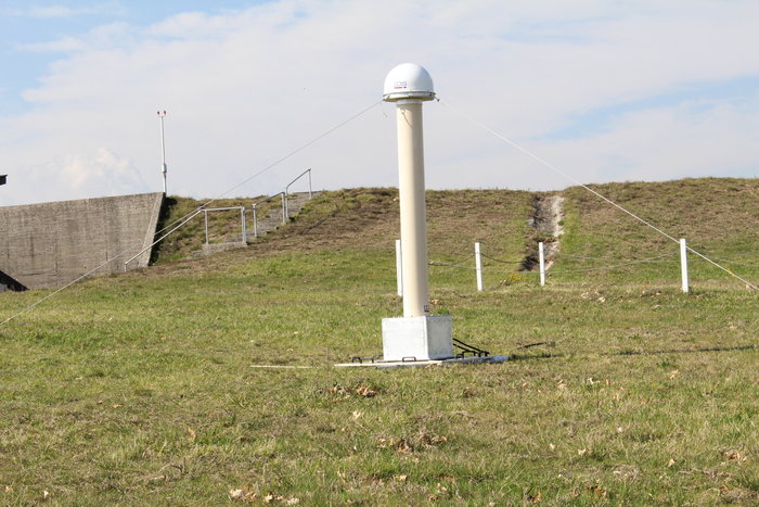
The current 40 Ranging and Integrity Monitoring Stations (RIMS) sites across Europe and beyond are the bedrock of the European Geostationary Navigation Overlay Service (EGNOS), supplying highly accurate and robust satnav information that can be relied on for safety-critical purposes.
Thales EGNOS V3 RIMS rack.
Once a second, these stations gather raw satnav data to transmit information on signal quality and range measurements to the GPS satellites, allowing EGNOS to identify and remove any error in the signals.
The resulting corrections are then passed to users via a trio of geostationary satellites, delivering a several-fold increase in precision plus “integrity” — a guarantee of navigation service — for safety-of-life applications.
The result is that the EGNOS-augmented signals are guaranteed to meet the extremely high performance standards set out by the International Civil Aviation Organisation standard, adapted for Europe by Eurocontrol, the European Organisation for the Safety of Air Navigation.
The signals from space can therefore be relied on routinely for safety-critical tasks, such as vertically guiding aircraft during landing approaches.
“These current RIMS V2 stations have some inherent limitations, which we’ve sought to tackle in this upgraded V3 design,” said Didier Flament, ESA’s EGNOS programme manager.
Airbus EGNOS V3 RIMS rack.
“For instance, our current stations work only with GPS frequencies L1/L2 P(Y), while the future post-2020 EGNOS system will be operating on a multi-constellation basis, additionally employing modernized GPS signals, notably on both the L2 (L2C) and L5 frequency bands, as well as other signals from Galileo, on the similar E1 and E5 frequency bands.
“Our experience working with RIMS has emphasized the significance on performance of factors such as signal scintillation — caused by the ever-changing ionosphere, the electrically active layer of the upper atmosphere — as well as other environmental threats such as interference and multipath signal reflection.
“So this upgraded design increased robustness to these factors, based on more stringent development and operating standards, along with innovative radio-frequency environment monitoring.
“It also includes upgraded receiver technology to accurately monitor potential GPS and Galileo signal distortion — ‘evil waveform’ signal anomalies — in full compliance with international standards.”
The RIMS V3 stations will be based in the same or similar secure location as today’s stations — typically airports or space-based telecommunication sites.
Dual tracking antenna concept incorporated in EGNOS V3 RIMS design.
The individual RIMS antennas themselves can be relatively compact, about 50 cm high, with links to receiver and computing equipment.
Most of the RIMS V2 station antennas are currently surrounded by dedicated protection structures that limit the impact of interference and multipath local effects.