Septentrio’s mosaic-T is built specifically for resilient and precise time and frequency synchronization under challenging conditions. (Photo: Septentrio)
Fugro has signed a tri-party cooperation agreement with GNSS receiver company Septentrio and synchronization equipment manufacturer Meinberg to launch the Fugro AtomiChron real-time synchronization and authentication service.
Numerous sectors rely on resilient and highly accurate time synchronization, including telecommunications, finance and energy. The timing technology eliminates time drift caused by clocks counting time at slightly different rates, and provides extreme stability that surpasses current precision frequency standards.
With up to sub-nanosecond accuracy, Fugro AtomiChron includes Navigation Message Authentication (NMA), ensuring reception of genuine GNSS signals and time synchronization improvements. Integrated anti-spoofing detection further prevents interference with GNSS timing signals providing accuracy, authentication, validity and security for end users.
The agreement ensures that the Fugro AtomiChron service will be available in new Septentrio mosaic-T GNSS receivers, as well as a selection of Meinberg GNSS clocks, without the need for additional physical interfaces or separate antennas.
“Septentrio is a forerunner in the area of robust and resilient GNSS solutions,” said Jan Van Hees, business development director at Septentrio. “With the addition of the unique Fugro AtomiChron service, we are pleased to further strengthen our offering and provide our customers even more accurate and reliable solutions for resilient GNSS timing.”
Teren, a climate resilience analytics company, has expanded its Premium 4D Content program for regions across the United States, including the Gulf Coast, Midwest, Rocky Mountains and West Coast.
Teren acquires and quickly processes high-fidelity lidar data, making it available via its content library, and delivers analytics with actionable insights to energy and engineering firms.
“Climate change is causing drought, flooding, landslides and wildfires across the country – significantly impacting asset owners and project developers. As a result, the market demand for high-fidelity, temporal data to identify, prioritize, and monitor climate-related risk is higher than ever,” said Toby Kraft, Teren CEO.
Teren is amassing a content library of remotely-sensed 3D (spatial) data across the United States. That data is updated on regular intervals to monitor changes over time providing a unique 4D (temporal) view. This 4D data library feeds analytics that identify risk, inform mitigation, and strengthen asset resilience. While remotely-sensed data has traditionally been sourced on a project-by-project basis, Teren offers its data and analytics as a subscription service. This model drives down the costs for clients and stakeholders, helping to maximize the speed of delivery, return on investment, and data value.
“In our flagship content region, Appalachia, our customers tap into our 4D content library to identify and monitor the terrain and surface conditions surrounding their assets — primarily aiming to identify and mitigate landslides before they become catastrophic incidents,” Kraft said. “We’re expanding the program nationwide to meet the growing demand for terrain monitoring and climate resilience analytics around events such as erosion, flooding, wildfires and more.”
Teren’s solution saved clients in Appalachia an estimated $152 million annually, preventing 24 failures per year due to landslides. While landslides are not as pervasive across the United States, companies can apply the data and analytics suite for the following:
Gulf Coast: inundation, subsidence, land movement
Midwest: erosion, flooding, subsidence
Rock Mountains: landslides, flooding, wildfire
West Coast: wildfires, land movement, flooding.
Traditionally used by the energy sector, Teren’s data has also proven to be highly valuable to state and federal agencies, insurers and civil engineers. Teren expects to see increased variability across clients and use cases as the content region expands.
To learn more about Teren or to request a demo, visit www.teren4d.com.
The Autel Robotics Dragonfish Lite and Pro UAVs are now available in the United States, joining the Dragonfish Standard and providing more options and choices for UAV pilots.
The rugged Dragonfish UAVs are capable of vertical takeoff and landing (VTOL) with both multi-rotor and winged flight, with an endurance of up to 180 minutes. They are suitable for professional applications such as energy, mining, defense and surveillance. Maximum winged flight speed is 30 m/s (108 km/h, 67 mph), and maximum video transmission range is 30 km (18.6 miles) with a base station.
The 1-tap take-off and landing capability point-and-click user interface, and other smart autonomous features make the Dragonish simple for anyone to operate, according to maker Autel Robotics. The aircraft can make a smart decision to either land or return to base in case of issues such as loss of GPS signal, loss of operator communications, or low battery power.
The Dragonfish tilt-rotor system will automatically transition to multi-rotor mode if adverse conditions cause fixed-winged flight to stall or become unsustainable. The Dragonfish battery, barometer, positioning system, compass and inertial measurement unit all have backup modules to ensure flight safety.
Dragonfish UAVs can carry a variety of payloads, including standard high-resolution cameras, 50x optical zoom cameras, 12-megapixel wide-angle cameras, 1280 x 1024 high-resolution infrared cameras, and laser rangefinders for various imaging, surveillance and mapping tasks.
All Dragonfish UAVs are built from tough carbon-fiber and fiber-glass composite, providing excellent IP43 wind and weather resistance. Despite the strong construction, these aircraft are designed to be easily disassembled for space-saving transport. They can be assembled in three minutes without tools. Disassembled, Dragonfish fits in the back of any car or SUV.
The larger Dragonfish Pro provides the longest flight time of the series, 180 minutes with payload, and has a 6,000-m (19,685-ft) flight ceiling, making it suitable for applications such as discreet long-endurance surveillance and wide-area mapping. The maximum payload capacity is 2.5 kg.
Compact and lightweight at 4.5 kg (including two batteries) with a 1,600-mm wingspan, the Dragonfish Lite can carry a 1-kg payload up to its service ceiling of 4,000 m, and has 75 minutes’ flight endurance.
Dragonfish Standard is already available. Dragonfish Lite and Dragonfish Pro will be available in the U.S. starting in April.
Firmware Release
The company also announced that pilots of Autel Robotics’ EVO Nano and EVO Lite series drones can download a firmware update that adds features including Dynamic Track 2.1 (person only), SuperDownload, 8-bit Log video, HDR video and other improvements. Some of these new firmware features are available now for selected models, and other features will become available for the EVO Lite, Lite+, Nano and Nano+ series in the near future.
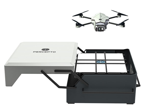
Percepto Air Mobile drone with base. (Photo: Percepto)
Percepto, an Israel-based company specializing in autonomous inspection with industrial robotics, has launched its 2022 Autonomous Inspection & Monitoring (AIM) platform and Air Mobile drone.
Recently listed in TIME magazine’s 100 Best Inventions of 2021, Percepto offers an end-to-end solution powered by artificial intelligence (AI) to collate and streamline all visual data for accurate actionable insights.
Percepto AIM 2022 has a new Insight Manager to deliver AI-powered packaged solutions for sector-specific use cases, such as solar, mining, energy, oil and gas and other industries. The company drew on tens of thousands of hours collected by autonomous robot missions at industrial facilities to create it.
Percepto’s AI change-detection framework offers unified visual data and critical business insights for each of the sector-specific solutions. AIM 2022 can be integrated with autonomous drones and robots as well as other visual data collectors, now including DJI drones, and fixed cameras.
Reports and insights are automatically generated based on the combined visual data. Disseminated to relevant stakeholders on any mobile device, issues and faults are geotagged and displayed on a map, enabling effective action before escalating into more serious problems.
Percepto also introduced its new Percepto Air portfolio to support the enhanced platform, which will address the diverse needs and increasing demands of various markets.
Percepto Air Max. The next generation of Percepto Sparrow, the Percepto Air Max is a field-proven solution that operates in the largest mining, oil and gas, and energy companies on six continents. It has a top-grade, versatile payload for specific use cases. Designed to inspect and map complex industrial environments where the highest accuracy and durability are critical, Air Max also has an optical gas imaging (OGI) camera.
Percepto Air Mobile. This option is a more compact and lighter weight model for smaller sites or organizations taking their first steps with a drone-in-the-box program, or larger sites that need greater deployment flexibility. It is designed for linear inspections, such as pipelines and power lines, and can monitor short-term projects across multiple sites, such as construction sites.
Percepto Air Max and Air Mobile drones are stored permanently onsite within their respective Percepto Bases. The Air Mobile’s base is light and easy to relocate while maintaining high levels of durability. These encasements are designed for infrequent maintenance and protection against extreme environmental phenomena, such as hurricanes. Percepto’s drones are safe and regulation ready, and ensure all operational aspects meet corporate standards.
“Percepto AIM 2022 and the new Percepto Air line of drones, together with the most advanced change detection solution, alert and prevent failures and downtime within diverse use cases across many industries,” said Percepto CEO Dor Abuhasira. “Percepto AIM provides the most advanced and comprehensive enterprise inspection software that offers a complete data workflow — from capture to insight. With Percepto Air Max and Percepto Air Mobile, companies have a range of options to choose from depending on the size of their facilities and the flexibility needed to deploy drones.”
“The real power of Percepto’s system is how data collection and analytics are integrated for a holistic view from both a technical and management perspective,” said Tim Shanfelt, director of Operations Transformation, Koch Ag & Energy. “Our workers are connected to high-level information that helps them make the right decisions while keeping them safe and free to pursue higher value activities. Our goal is to eliminate hazardous, wasteful, and mundane tasks from our operators’ day. For example, instead of an employee climbing an icy ladder in the winter, a robot or drone can perform the same task while still obtaining accurate measurements. We see Percepto playing a significant role in helping make our facilities more safe, secure, efficient, and profitable.”
Thales Alenia Space has been awarded a grant under the European GNSS Agency’s (GSA) Fundamental Elements funding mechanism for the development of the GIANO (Galileo-based TIming Receiver for CriticAl INfrastructure Robustness) receiver, which aims to make critical infrastructure more robust against interference, jamming and spoofing.
In an increasingly complex GNSS environment in which there is both unintentional and deliberate disruption of satellite signals, the GSA is funding the development of a timing receiver for professional applications to address the needs of the critical infrastructure user community, mainly energy generation and distribution, telecommunications and financial operators.
Improved resilience
The GIANO receiver will leverage Galileo and EGNOS-driven innovation to improve the resilience of the receiver against interference, jamming and spoofing and increase the accuracy and reliability of the time transfer service. The timing platform prototype to be developed and validated will integrate all the latest innovative technologies, including professional products from Thales Alenia Space, paving the way for future Galileo-based timing receivers that offer improved resilience and accuracy at a reasonable cost.
“Critical infrastructure operators use GNSS for timing and synchronisation and are an important target segment for GSA Market Development because Galileo can make a difference. By funding the development of the GIANO receiver, the GSA aims to provide technological solutions to this community for robust and reliable timing,” said GSA head of market development Fiammetta Diani.
Toward this goal, outreach activities have been conducted among potential final users in the main commercial target groups to collect and analyse their needs. Then, following the definition and consolidation of stakeholders’ needs and the platform specifications, the project conducted a preliminary design review at the end of November 2019.
Europe-wide cooperation
The two-year project, funded under a GSA grant related to the Development of a Galileo-based timing receiver for critical infrastructures (GSA/GRANT/05/2017), will be coordinated by Thales Alenia Space in Italy, in collaboration with four European partners: Business Integration Partners S.p.A (BIP, Italy), PIKTime Systems (Poland), Space Research Centre of the Polish Academy of Science (SRC PAS, Poland) and DEIMOS (Portugal).
The project will also benefit from the support of the European Commission’s in-house science service – the Joint Research Centre (JRC) and the Italian National Metrology Institute (INRIM), which will make available its test facilities for verification activities on the developed equipment.
Geospatial Corporporation announces the long-awaited passage of the PIPES Act of 2016. The bill, recently signed into law by President Obama, empowers the Pipeline Hazardous Material Safety Administration (PHMSA) to require various certifications, data management, testing and mapping of all types of the more than 3 million miles of buried energy pipelines across the USA.
“The PIPES ACT impacts all segments of the industry, including gathering systems, transmission and distributions systems,” said Mark Smith, Chairman and CEO of Geospatial Corporation. “The Oil and Gas markets are a major part of our current and future business, and recently we have clients giving serious attention to accuracy and completeness of their asset mapping in anticipation of the new regulations. ”
As a Google Maps Technology Partner, Geospatial Corporation is positioned to provide management capabilities, technology, software and data management processes to owners of critical underground infrastructure located across the United States in compliance with the new legislation.
Measure, a United States’ commercial operator of drones, and DJI, manufacturer of unmanned aerial vehicles, are partnering to pair advanced UAV technology with operational excellence so commercial enterprise customers can achieve their most demanding business goals.
“Our partnership with DJI allows Measure to enhance technical capability and scale business operations across all verticals,” said Measure CEO Brandon Torres Declet. “This alliance will allow our companies and franchisees to be the vanguard of innovation for commercial UAV operations, using DJI’s proven technology and our experienced pilots.”
“Businesses increasingly recognize that having a knowledgeable and experienced operator at the controls is key to using UAV technology most effectively,” said Jan Gasparic, Strategic Partnerships and Business Development, DJI.
“Measure’s application-specific pilot training and deep knowledge of flight regulation allows them to set the standard for commercial UAV operations in the field,” Gasparic said. “We are looking forward to expanding our successful relationship with Measure, allowing more businesses to perform critical functions faster, safer, more efficiently and at a lower cost.”
Alongside the service collaboration, Measure and DJI will assist organizations to develop and deploy UAV operations in the fields of agriculture, energy and media. Organizations will now have a comprehensive partner to explore demanding operations such as spraying with DJI’s Agras MG-1 agricultural drone, or broadcasting live directly from a UAV to a newsroom. This partnership demonstrates Measure and DJI’s commitment to fostering a vibrant commercial ecosystem to accelerate the economic growth and innovation of the drone industry.
CoreLogic, a residential property information, analytics and data-enabled services provider, today released an expanded version of its natural catastrophe risk management solution, which features a new comprehensive probabilistic flood model that analyzes the potential damage and financial impact at the property-level from flood events in the continental United States.
This probabilistic flood model is unique to the industry because its riverine and flash flood risk components provide better risk estimation for areas outside the 100-year flood zones–areas responsible for 20 percent of historic flood losses but which represent only 1 percent of the flood insurance policies in force.
Measuring both severity and frequency of flood events, the probabilistic flood model loss calculations offer property, contents and business interruption analysis. The model also incorporates historical flood event footprints from the last 50 years and the accompanying property damage.
Additionally, the model incorporates detailed user-provided building information to derive vulnerability assessments driven by both water depth and water velocity. These building characteristics include construction type, occupancy, floor elevation, basements and elevated building configurations. The new CoreLogic flood model provides insurers with an unprecedented tool to more accurately underwrite the risk associated with this complex peril, especially the proprietary flash flood component.
With granular 10-meter elevation data, the catastrophe risk management solution incorporates the Digital Flood Insurance Rate Maps (DFIRMs) provided by the Federal Emergency Management Association (FEMA). It uses more than 80 different occupancy classes covering topography, land-use, stream coverage and inundation. In order to more accurately measure a property’s flood risk, more than 50 data layers ranging from elevation, hydrologic and catchment information are included, as well as data for over 6 million miles of streams and 20,000 stream flow gauges.
“The release of the U.S. Inland Flood Model means insurers can now use this advanced probabilistic tool to help them determine a property’s potential for flood damage,” said Tom Larsen, CoreLogic product architect. “The model’s unique ability to provide granularity down to the property level will offer insurers a complete view of flood risk, including contents and business interruption, for all types of properties.”
The catastrophe risk management solution contains parcel-level geocoding through PxPoint from CoreLogic, which can convert physical addresses or locations into precise geographic coordinates for over 142 million parcel boundaries. A new visualization feature identifies details in the data as well as exceptions via easy-to-use charts and graphics. Other new components include updates to three risk assessment models including Italy Earthquake, the North Atlantic Hurricane Risk and U.S. Offshore Energy.
Highlights include:
The Italy Earthquake Model now incorporates an updated seismic source model based on the Seismic Hazard Harmonization in Europe (SHARE) to provide a current and more accurate view of seismic hazard in Italy. Increased maximum magnitudes, an updated magnitude-frequency distribution and a new ground motion model are part of the enhancements.
The North Atlantic Hurricane Risk Model update includes a high-resolution storm surge model and enhanced hazard risk assessment to more accurately capture the damage from storm surge as the surge attenuates inland (outside of the high velocity zones). It uses storm intensities from historical events based on the Atlantic hurricane reanalysis project by the National Oceanic and Atmospheric Administration (NOAA). Additionally, the North Atlantic Hurricane Risk Model includes a full set of default secondary structural modifiers by vintage and location for all hurricane states, which are based on the International Building Code as well as state-specific building codes to provide refined results. RQE 16 also includes a model version which was certified by the Florida Commission Hurricane for Loss Projection Methodology in June 2015.
The U.S. Offshore Energy Model features a distinctive wave model component and unique financial model which produces an improved estimate of potential damage to physical assets in U.S. territorial waters within the Gulf of Mexico. A network analysis is also built into the model to produce a better estimate of the lost production from oil wells.
“All of these enhancements will help insurers understand hazard risk in a more granular and comprehensive way, and this precision in risk modeling will help the industry overall fine-tune its underwriting, claims and reinsurance efforts,” Larsen said.
Getmapping has partnered with PlanetObserver to offer customers a full range of global and regional Earth satellite imagery along with global height data. The partnership is in line with Getmapping’s wider strategy to extend its reach beyond its established markets in the UK and Africa and signals an intention to provide a global capability in geospatial products and services.
The key PlanetObserver offerings available from Getmapping include PlanetSAT 15, 15-m resolution global satellite imagery and two height data products, PlanetDEM 30 and PlanetDEM 90 with resolutions of 30 m and 90 m respectively.
The satellite imagery is the most up to date satellite dataset currently available and provides natural colour (RGB) imagery free from clouds. Available from a few square kilometers to global coverage, the data is especially suited to a wide range of sectors, including energy and utilities, tele-communications and smartphone apps, visualization and simulation, plus mapping and illustration.
The PlanetDEM height datasets are seamless global digital elevation models at 30m and 90m resolution and are derived from a combination of SRTM (Shuttle Radar Topography Mission v4.1) data corrected with multi-source cartographic data, and are perfect for 3D simulation and visualisation applications, base mapping, energy and geological surveys.
All PlanetObserver data is delivered in a range of standard formats, and is also available via WMS and as an additional layer in the Getmapping Online GIS software.
“We have been providing high-quality aerial imagery and elevation data across the UK and Africa for a number of years and it has always been our intention to provide our customers with a global offering,” said Pete Bonham, Getmapping’s Business Manager. We expect satellite imagery and DEMs to be particularly popular with our Online GIS customers who can subscribe to access the data from within the application. The high quality data from PlanetObserver covers the entire surface of the Earth, and provides excellent base layers for our expanding Online GIS application, it really adds value to our offering.”
Laurent Masselot, CEO of PlanetObserver added, “Our new cooperation with Getmapping is a major step forward to efficiently supply our geospatial data to a large user community. We’re particularly excited to reach out to users of Getmapping online GIS software and have them take advantage of our value-added products.”
Under the theme “Taking the Pulse of the Planet,” 275 members of the GEO community from more than 45 countries will chart the next steps in creating and implementing a Global Earth Observation System of Systems (GEOSS) during the Group on Earth Observations (GEO) Eleventh Plenary Session. The session will be held November 12-14 in Geneva, Switzerland.
A highlight of the conference will be announcement of the winners of the GEO Appathon, a global app development competition built on the 80-million-plus resources available through GEOSS. The Appathon attracted 250 competitors from 50 countries, and will generate easy-to-use decision tools for mobile devices and computers.
GEO’s mandate is to harness the power of Earth observations from sources across the globe to provide more and better information to leaders in government, industry, and civil society confronting fundamental decisions affecting people and societies worldwide. One key GEO initiative that will be highlighted during the meeting is developing a comprehensive system to monitor the availability and quality of fresh water, in partnership with the World Health Organization, the UN Environmental Programme and other UN agencies as part of the UN Sustainable Development agenda.
GEO is leading the creation of an Africa-wide technological and human infrastructure so decision makers have the capacity to access and use Earth observations in making key decisions. To strengthen agricultural activity and reduce market volatility, GEO is coordinating the assessment of growing conditions of the world’s major crops through a combination of regional expertise, ground observations and analysis of meteorological and satellite data.
GEO is a voluntary partnership of governments and organizations that envisions “a future wherein decisions and actions for the benefit of humankind are informed by coordinated, comprehensive and sustained Earth observations and information.” Members include 94 nations and the European Commission and 77 participating organizations comprised of international bodies with a mandate in Earth observations.
GEO’s agenda spans nine Societal Benefit Areas, including agriculture, biodiversity, climate, disasters, ecosystems, energy, health, water and weather.
On August 29, OmniEarth completed its acquisition of IRISmaps, Inc., in a stock-for-stock transaction. IRIS provides customized, cloud-based solutions that integrate Earth imagery with geospatial and business data to enable organizations to access information, analyze it, and take action to solve business problems quickly and effectively. The combined companies will be led by OmniEarth CEO, Lars Dyrud.
“We’re very excited about bringing IRIS into our team. The capabilities they bring will enable OmniEarth to deliver our value-added data stream to subscribers as soon as our constellation goes live,” Dyrud said. “IRIS also brings a portfolio of off-the-shelf products that provide the customer focused analytics platform that is crucial for turning data into insight.”
IRIS’ portfolio includes asset and environmental monitoring products that have been deployed at major agriculture and energy companies, and in the public sector. Dyrud sees this as a natural fit for OmniEarth, which is focusing its initial business offerings on underserved markets like agriculture and energy.
With the IRIS acquisition, OmniEarth will be well-positioned to deliver solutions that will inform all phases of energy exploration and development, Dyrud said. Specifically, the company plans to continue IRIS’ energy portfolio products, such as high-consequence area monitoring and thermal steam cycle analysis, as well as establish new ones that combine the talents of the IRIS software developers with rich data fusion and analytics enabled by the planned OmniEarth constellation.
PeopleNet, a Trimble company and provider of fleet mobility technology that optimizes performance and decision-making management, has launched a mapping and navigation solution for its Energy Services suite, serving U.S. fleets in the upstream and midstream sectors.
“Our Energy Services suite capitalizes on our proven fleet mobility solutions that increase efficiency, safety and compliance for all oilfield service segments, including producers, oilfield construction and well service companies, as well as haulers of fluid and crude oil. In addition, we’re leveraging our parent and sister companies’ industry-standard lone-worker, mapping and navigation technologies to fast-track development of new services to continue improving operations for Energy Services fleets,” said David Buhl, leader of PeopleNet’s dedicated Energy Services Division.
PeopleNet’s new Energy Services mapping and navigation solutions are based on exclusive, detailed maps of private and leased oilfield roads that facilitate vehicle navigation to and from well sites, coordination of disparate workforces to promote efficiency, location monitoring of equipment to ensure vehicles are on the correct route for least-cost routing. The Oil and Gas Map Portal is a web-based application used by back-office dispatch personnel to manage the navigation needs of vehicles and includes reporting, dashboards, and scorecards that help manage compliance with producer-landowner road-usage agreements.
CoPilot Oil and Gas Navigation is an in-cab application that uses oil and gas field mapping for providing turn-by-turn directions to the driver to enable on-time arrivals and scheduling. Location data, including wells, is installed onto the in-cab device and is accessible in the points of interest menu. When a location is selected, the application provides turn-by-turn directions to the driver.
A growing number of energy services fleets are using PeopleNet technology to promote on-time schedules, enhance service levels and improve safety/compliance, including Gibson, Missouri Basin Well Service, Nuverra Environmental Solutions, Rockwater, and Tankstar USA.
These new services are based on reliable two-way messaging and GPS, supported by tri-mode communications (cellular, satellite and Wi-Fi). They are being added to PeopleNet’s current Energy Services offerings, which include: Crude Workflow for improving driver efficiency; eDriverLogs HOS application with oil field regulations; Speed Gauge speed monitoring; and Automated Fuel Tax reporting for eliminating manual trip sheets.