Eos Positioning Systems, the global manufacturer of Arrow Series GNSS receivers, has released Eos Bridge, which enables almost any instrument to become iOS Bluetooth compatible.
Photo: Eos Positioning
The Eos Bridge is a small, pocket-sized device that connects to instruments via Bluetooth Classic or serial port, and transmits data from them to any Apple iOS device, such as iPhone or iPad, Android device or Windows mobile device.
The Eos Bridge offers two connectivity methods to virtually hundreds of instruments:
First Method: Bluetooth Classic to Apple iOS Bluetooth
Instruments that are equipped with non-iOS Bluetooth are now able to connect to Apple iOS devices using the Eos Bridge, including laser rangefinders and utility-locating instruments.
Second Method: Serial port to iOS, Android and Windows devices
With the Eos Bridge, instruments whose only connectivity option is a serial port may now be connected to any iOS, Android or Windows device via Bluetooth. This includes any instrument or sensor with an RS-232 serial port, for example.
The Eos Bridge is lightweight, at approximately 150 grams (about 5.3 ounces). It can be worn clipped to a belt, stored in a pocket, or mounted to an instrument or sensor. The battery lasts 48 to 72 hours.
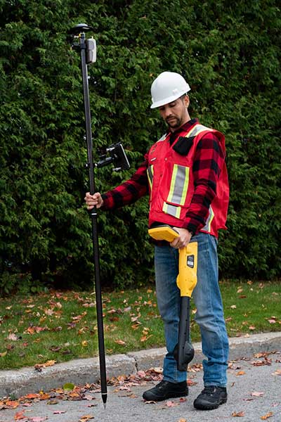
The Eos Bridge expands the potential pairings of legacy instruments and sensors by making them Bluetooth compatible with modern mobile devices and Arrow GNSS receivers. Two immediate applications for current Arrow GNSS users include Eos Laser Mapping for ArcGIS offset data-collection, and Eos Locate for ArcGIS for underground utility mapping. Both solutions are available on iOS.
Eos Locate for Collector for ArcGIS underground mapping is now compatible with three Subsite Electronics products.
Introduced in 2019 by Eos Positioning Systems, Eos Locate is a real-time, survey-grade solution for mapping underground utilities with ArcGIS field apps. With Eos Locate, one field worker can collect both GNSS locations and locator data (such as depth below cover) for any buried asset including water, sewer, electric, cable, gas, fiber infrastructure and more. They can do so quickly, accurately and without the need for any additional field or office support.
The solution requires an Arrow GNSS receiver, Esri licensing, an iOS device, and a compatible locator.
This expansion adds compatibility for two new utility locator models and one HDD guidance system: the UtiliGuard (with Bluetooth option enabled), UtiliGuard 2, and TK Recon. Eos Locate for Collector combines three core technologies: Eos Arrow GNSS receivers, Esri Collector and the Vivax-Metrotech vLoc Series of locator devices.
“We are extremely excited to expand this popular underground mapping solution to Subsite Electronics customers,” said Eos Chief Technology Officer Jean-Yves Lauture. “Utilities have been asking us to add compatibility, and we are pleased to announce that this integration is now available today, for no extra cost, to our existing customers.”
“At Subsite, we are constantly listening to customer needs and providing solutions accordingly,” Subsite Electronics Senior Product Manager Christopher Thompson said. “We have a lot of customers who perform this type of work, and by partnering with Eos, we are able to provide a solution today to continue providing our customers with the tools and technology for total underground awareness.”
Thanks to the TK Recon integration, it is now possible to map horizontal directional drilling operations in real-time with Eos Locate, for both performing as-built reports and monitoring.
To use Eos Locate with Subsite devices, customers must download Eos Tools Pro (version 1.89 and higher) from the App Store for free. Eos Locate is compatible with both Esri ArcGIS Collector and ArcGIS Field Maps. Follow this manual or watch these video tutorials to get started.
Eos will announce compatibility of its Arrow GNSS receivers with the inaugural ArcGIS Field Maps beta release, the expansion of Eos Locate underground mapping locator-device compatibility, as well more exciting updates for users of high-accuracy GPS with ArcGIS apps.
Eos Positioning Systems, manufacturer of the high-accuracy Arrow Series GNSS receivers for the GIS market, has announced several new releases ahead of the 2020 virtual Esri User Conference.
The announcements include the expansion of the availability of the Eos Locate
underground mapping solution, compatibility with the new ArcGIS Field Maps, the inaugural release of Eos Tools Pro for Windows, and a “special surprise” for virtual attendees of the 2020 Esri UC.
Image: Eos Positioning
Expansion of Eos Locate
Eos Locate is a high-accuracy, real-time underground mapping solution for Esri
ArcGIS apps users. It allows organizations to accurately map already-buried assets straight to ArcGIS Online via either ArcGIS Collector or ArcGIS Field Maps.
Eos has expanded Eos Locate compatibility with additional models from Vivax-Metrotech, Subsite and Radiodetection.
Compatibility with ArcGIS Field Maps beta
ArcGIS Field Maps is the newest Esri mobile application, which combines the functionality of several existing Esri mobile applications, such as ArcGIS Collector, ArcGIS Explorer, and ArcGIS Tracker.
The ArcGIS Field Maps beta release this month is already fully compatible with Arrow GNSS receivers (all models). This means organizations with Arrow GNSS receivers can immediately start taking advantage of survey-grade Arrow GNSS locations and metadata within ArcGIS Field Maps for data collection, markups, read-only routine field work (e.g., utility locates), GPS tracking, and more.
In addition, two Eos solutions previously exclusive only to Collector also already work with ArcGIS Field Maps. These include:
Eos Tools Pro is a free GNSS monitoring application for Arrow GNSS receivers. For the first time, this app is now available for Windows 10 users.
Eos Tools Pro allows fieldworkers to:
Connect to an RTK network or base station via NTRIP
Get elevations in orthometric heights via geoid model conversions in real time, in the field (directly into an Esri app)
Apply a simple X, Y, Z datum shift to the current location to match any local datum
Set a vast number of audible alarms
In addition, developers using Windows 10 will now be able to access the wide array of Arrow GNSS metadata while eliminating the task of parsing NMEA data.
Finally, Eos Tools Pro features a built-in duo of virtual Com Port and TCP/IP server to output streams of standard NMEA sentences. This enables multiple apps to have simultaneous access to the Arrow GNSS location and metadata.
Special surprise for eligible 2020 Esri UC attendees
In support of the inaugural virtual Esri UC, Eos is offering a one-time-only chance to win an Arrow 100 submeter GNSS receiver. To enter to win, eligible attendees must both
Complete a meeting with an authorized Eos representative during the 2020 Esri UC (July 13-16), which can be achieved by visiting the Eos virtual booth (V103), and
Fill out a special contest contact form made available by that representative.
Both the meeting and special contest contact form submission must be completed no later than July 16.
The following people are not eligible to win: Employees of Eos and Eos distributors, employees of Esri and Esri distributors, employees of other exhibiting/sponsoring companies, employees of other GPS manufacturers or vendors, registered media, and others whom we deem to have a similar affiliation.
Visit the Eos virtual booth (V103) to talk with sales, marketing, and technical support staff during the event expo hours.
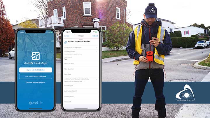
A new Esri mobile app, ArcGIS Field Maps, will be released in its first beta in July, with the final version expected to be released in September.
According to Esri, Field Maps will combine the following capabilities into a single app:
Simple map viewing and markup
High-accuracy field data collection and inspection
Battery-optimized location tracking
Work planning and task management
Turn-by-turn navigation
Field Maps also will include a new web app, integrated with ArcGIS, that can be used to configure and deploy maps optimized for your mobile workforce needs, create and assign tasks to mobile workers, and create and share views of worker locations.
Arrow support included
The inaugural beta includes support for Arrow GNSS receivers’ high-accuracy locations, elevations and metadata, according to Eos Positioning.
ArcGIS Field Maps will provide the combined functionality of five Esri mobile apps: ArcGIS Collector, ArcGIS Explorer, ArcGIS Tracker, ArcGIS Workforce and ArcGIS Navigator.
In the first beta version, users will be able to perform markups, work with read-only maps, and work with MMPKs, including high-accuracy GPS locations and metadata from Arrow GNSS receivers.
Photo: Eos Positioning
Customers who have been wanting to take advantage of high-accuracy GNSS data in apps such as Explorer and Tracker will now be able to with the beta release. Customers who would like to have field crews able to access read-only maps with high-accuracy, for instance (such as during utility locates), this is now a possibility. In addition, crews can take advantage of high-accuracy GPS tracks while tracking.
ArcGIS Field Maps will also support the two formerly Collector-exclusive Eos solutions Eos Locate and Eos Laser Mapping.
Eos Locate. This high-accuracy underground mapping solution will be available in ArcGIS Field Maps right away in the first beta release. A single fieldworker will be able to perform real-time, high-accuracy mapping of underground assets using the same workflow he or she had previously used with Collector and Arrow GNSS.
Eos Laser Mapping. Similarly, laser offsets with Arrow GNSS receivers and LTI laser rangefinders will be available in the first beta of ArcGIS Field Maps. Learn more about laser offsets, including the three workflows for using them, here:
“We are incredibly excited for the new opportunities ArcGIS Field Maps brings to expand our partnership with Esri,” Eos CTO Jean-Yves Lauture said. “Now our joint customers will be able to use the Arrow GNSS receivers with Field Maps to access high-accuracy location when simply viewing and marking up maps and when logging location tracks.”
Eos Positioning told its customers, “We encourage all Eos customers currently using Collector, Tracker and/or Explorer to join the beta. Meanwhile, Collector, Tracker and Explorer are planned to continue working as usual, according to the roadmap Esri has outlined.”
Eos Locate for Collector combines three core technologies: Eos Arrow GNSS receivers, Esri Collector, and the Vivax-Metrotech vLoc Series of locator devices.
With Eos Locate for Collector, one field worker can collect both GNSS locations and locator data (such as depth below cover) for any buried asset including water, sewer, electric, cable, gas, fiber infrastructure and more. They can do so quickly, accurately and without the need for any additional field or office support.
“We are giving our Arrow GNSS customers a solution today that allows them to combine both locator data and high-accuracy locations in web maps,” Eos CTO Jean-Yves Lauture said. “This greatly simplifies their workflow by allowing one person to do underground locates and GIS mapping simultaneously.”
“This is a big step forward for utility organizations who need to gain better visibility of their infrastructure,” said Doug Morgenthaler, Esri program manager. “With today’s technology, utilities can already see where new assets are being put in the ground. The challenge historically has been figuring out where existing assets are.”
Eos Locate for Collector not only streamlines underground-asset mapping, but also improves office production times. It eliminates the need to manually combine datasets from the locator and GPS devices within ArcGIS.
“Seeing all that information from utility locators and GPS receivers packaged directly into a GIS application is exceptional,” Vivax-Metrotech Eastern Regional Sales Manager Kelvin Cherrington said. “This solution will help utilities create maps of their underground assets with a much more modern and efficient methodology.”
Indiana American Water Early Adoption
Earlier this year, Indiana American Water approached Eos to seek a solution that consolidated their utility-locate workflow with their Arrow and Collector field work.
“We had the manpower to put paint down,” said Todd Chapman, Indiana American Water Senior GIS Analyst. “But we would need to hire another person to map the locations with our Arrow Gold GNSS receivers.”
Chapman estimates Eos Locate for Collector will cut their field time in half as well as enable the creation of extremely accurate buried-infrastructure maps in ArcGIS.
“Previously, we were seeing that our old water mains could be off by up to 20 feet,” Chapman said. “With the new Eos Locate for Collector, we’re seeing that it’s accurate to under an inch.”
The initial release of Eos Locate for Collector runs on Apple’s iOS iPhones and iPads and supports the vLoc Series from Vivax Metrotech. Future releases of Eos Locate for Collector will support additional locator models including the vScan series.
With accurate digital twins of their buried infrastructure, utilities across sectors can expect improvements to safety, damage prevention, field efficiency and regulatory compliance.
“Not only does this mean quicker responses to 811 tickets and fewer liabilities during field digs,” Lauture said. “But it also constitutes a major step forward toward the highly efficient future of 3D asset management and viable augmented-reality workflows.”